Town Common, Queensland

Last updated

Town Common
Townsville,  Queensland
Town Common, 1892.jpg
Town Common, 1892
Australia Queensland location map.svg
Red pog.svg
Town Common
Coordinates 19°13′14″S146°44′24″E / 19.2205°S 146.7400°E / -19.2205; 146.7400 (Town Common (centre of suburb))
Population0 (2021 census) [1]
 • Density0.000/km2 (0.00/sq mi)
Postcode(s) 4810
Area37.6 km2 (14.5 sq mi)
Time zone AEST (UTC+10:00)
Location
LGA(s) City of Townsville
State electorate(s) Townsville
Federal division(s) Herbert
Suburbs around Town Common:
Coral Sea Shelly Beach Pallarenda
Bushland Beach
Mount Low
Town Common Coral Sea
Bohle Mount St John
Garbutt
Rowes Bay

Town Common is a coastal suburb of Townsville in the City of Townsville, Queensland, Australia. [2] In the 2021 census, Town Common had "no people or a very low population". [1]

Contents

It is locally known as "The Common". [3]

Geography

Town Common is bounded by the Bohle River to the west, by the Coral Sea to the north-west and east, and Townsville Airport (Garbutt) to the south. Most of the land is flat and at sea level with the exception of Mount Marlow ( 19°11′31″S146°44′27″E / 19.1919°S 146.7409°E / -19.1919; 146.7409 (Mount Marlow) ) in the Many Peaks Range in the north-east of the suburb which rises to 213 metres (699 ft). [4] [5] [6] The land in the suburb is mostly undeveloped with much of land contained within the Townsville Town Common Conservation Park ( 19°12′23″S146°44′35″E / 19.2064°S 146.7431°E / -19.2064; 146.7431 (Townsville Town Common Conservation Park) ). [7] [8] The western part of the suburb is a floodplain created by a mangrove-lined network of tributaries of the Bohle River. [9]

Shelly Beach ( 19°10′51″S146°44′58″E / 19.1809°S 146.7494°E / -19.1809; 146.7494 (Shelly Beach) ) is at the northern coast of the suburb, but is not accessible by road. [5]

The developed land is in the south-east of the locality consists of a golf course, the Garden Settlement Aged Care Village on Cape Pallarenda Road ( 19°13′02″S146°46′34″E / 19.2171°S 146.7760°E / -19.2171; 146.7760 (Garden Settlement Aged Care Village (former)) ), and a park. [10]

The wetlands that cover a majority of Town Common. Australian bustard Townsville Town Common June 1986 IMG 0021.jpg
The wetlands that cover a majority of Town Common.

The golf course is irrigated with treated waste water from the Mount St John Wastewater Treatment Plant in Mount St John. [11]

History

The wetlands and lowlands of Town Common the result of sand dune formation and water catchment drainage processes including erosion and sedimentation over thousands of years. Town Common was gazetted in 1869 as common land for the people of Townsville (established in 1864). In 1900 part of the wetlands was established as a sanitary reserve. In 1914 a pasturage reserve was established. [12]

In August 2016, Blue Care who operated the aged care village opened a new facility at Mount Louisa and transferred the existing aged care village residents to this new location. The structure of the aged care village remains abandoned in Town Common. [13]

Demographics

In the 2011 census, Town Common had a population of 163 people. The median age of the residents was 81 years, reflecting that the only residential land in the suburb is an aged care village. [14] [9]

In the 2016 census, Town Common had a population of 71 people with a median age of 85 years, being residents of the aged care village. [15]

In the 2021 census, Town Common had "no people or a very low population", due to the aged care centre closing. [1]

Education

There are no schools in Town Common. The nearest government primary school is Belgian Gardens State School in Belgian Gardens to the south-east. The nearest government secondary school is Townsville State High School in Railway Estate to the south-east. [9]

Amenities

Robertson Park is along the coast off Cape Pallarenda Drive ( 19°12′49″S146°46′34″E / 19.2137°S 146.7762°E / -19.2137; 146.7762 (Robertson Park) ) [16]

Rowes Bay Golf Club is in Emmerson Street ( 19°13′37″S146°46′31″E / 19.2270°S 146.7754°E / -19.2270; 146.7754 (Rowes Bay Golf Club) ). [10]

Related Research Articles

<span class="mw-page-title-main">Garbutt, Queensland</span> Suburb of Townsville, Queensland, Australia

Garbutt is a suburb of Townsville in the City of Townsville, Queensland, Australia. It is home to the Townsville International Airport and RAAF Townsville.

<span class="mw-page-title-main">Aitkenvale, Queensland</span> Suburb of Townsville, Queensland, Australia

Aitkenvale is a suburb of Townsville in the City of Townsville, Queensland, Australia. In the 2021 census, Aitkenvale had a population of 4,797 people.

<span class="mw-page-title-main">Picnic Bay, Queensland</span> Town in Queensland, Australia

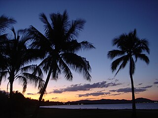
Picnic Bay is a town and suburb of Magnetic Island in the City of Townsville, Queensland, Australia. In the 2016 census, Picnic Bay had a population of 291 people. It is named for the bay on the southernmost corner of Magnetic Island where the town is situated.

Wulguru is an outer southern suburb of Townsville in the City of Townsville, Queensland, Australia. In the 2016 census, Wulguru had a population of 4,570 people.

<span class="mw-page-title-main">Horseshoe Bay, Queensland</span> Town in Queensland, Australia

Horseshoe Bay is a bay, town and suburb on Magnetic Island in the City of Townsville, Queensland, Australia. It is a major tourist accommodation and recreation centre on the island. In the 2016 census, the suburb of Horseshoe Bay had a population of 578 people.

<span class="mw-page-title-main">Rowes Bay, Queensland</span> Suburb of Townsville, Queensland, Australia

Rowes Bay is a suburb of Townsville in the City of Townsville, Queensland, Australia. In the 2016 census, Rowes Bay had a population of 573 people.

Mundingburra is a suburb of Townsville in the City of Townsville, Queensland, Australia. In the 2016 census, Mundingburra had a population of 3,620 people.

<span class="mw-page-title-main">Bushland Beach, Queensland</span> Suburb of Townsville, Queensland, Australia

Bushland Beach is a coastal suburb in the northern beaches area of Townsville in the City of Townsville, Queensland, Australia. In the 2021 census, Bushland Beach had a population of 6,641 people.

<span class="mw-page-title-main">North Ward, Queensland</span> Suburb of Townsville, Queensland, Australia

North Ward is a coastal suburb of Townsville in the City of Townsville, Queensland, Australia. In the 2016 census, North Ward had a population of 5,065 people.

Pallarenda is a northern coastal suburb of Townsville in the City of Townsville, Queensland, Australia. In the 2016 census Pallarenda had a population of 791 people.

<span class="mw-page-title-main">Bluewater, Queensland</span> Town in Queensland, Australia

Bluewater is a town and coastal suburb in the City of Townsville, Queensland, Australia. In the 2016 census the suburb of Bluewater had a population of 1,040 people.

Saunders Beach is a coastal town and suburb of Townsville in the City of Townsville, Queensland, Australia. In the 2016 census, the suburb of Saunders Beach had a population of 409 people.

<span class="mw-page-title-main">Yabulu, Queensland</span> Suburb of Townsville, Queensland, Australia

Yabulu is a town and coastal suburb in the City of Townsville, Queensland, Australia. In the 2016 census, Yabulu had a population of 697 people.

<span class="mw-page-title-main">Balgal Beach, Queensland</span> Suburb of Townsville, Queensland, Australia

Balgal Beach is a coastal suburb and a beach in the City of Townsville, Queensland, Australia. The town of Balgal is within the locality. In the 2021 census, Balgal Beach had a population of 998 people.

<span class="mw-page-title-main">Mount St John, Queensland</span> Suburb of Townsville, Queensland, Australia

Mount St John is an industrial suburb of Townsville in the City of Townsville, Queensland, Australia. In the 2016 census Mount St John had a population of 62 people.

<span class="mw-page-title-main">Bohle, Queensland</span> Suburb of Townsville, Queensland, Australia

Bohle is a northern suburb in the City of Townsville, Queensland, Australia. In the 2016 census, Bohle had a population of 85 people.

Mount Low is a suburb of Townsville in the City of Townsville, Queensland, Australia. In the 2016 census, Mount Low had a population of 4,655 people.

<span class="mw-page-title-main">Florence Bay, Queensland</span> Suburb of Magnetic Island, Queensland, Australia

Florence Bay is a suburb of Magnetic Island in the City of Townsville, Queensland, Australia. In the 2021 census, Florence Bay had a population of 0 people.

<span class="mw-page-title-main">Burdell, Queensland</span> Suburb of Townsville, Queensland, Australia

Burdell is a suburb of Townsville in the City of Townsville, Queensland, Australia. In the 2021 census, Burdell had a population of 7,171 people.

Lynam is a rural locality in the City of Townsville, Queensland, Australia. In the 2021 census, Lynam had a population of 8 people.

References

  1. 1 2 3 Australian Bureau of Statistics (28 June 2022). "Town Common (SAL)". 2021 Census QuickStats. Retrieved 28 February 2023. OOjs UI icon edit-ltr-progressive.svg
  2. "Town Common – suburb in City of Townsville (entry 44647)". Queensland Place Names. Queensland Government . Retrieved 14 February 2022.
  3. "Revitalising the Townsville Town Common" (PDF). Archived (PDF) from the original on 19 January 2021. Retrieved 17 April 2016.
  4. "Mountain peaks and capes - Queensland". Queensland Open Data. Queensland Government. 12 November 2020. Archived from the original on 25 November 2020. Retrieved 25 November 2020.
  5. 1 2 "Mountain ranges beaches and sea passages - Queensland". Queensland Open Data. Queensland Government. 12 November 2020. Archived from the original on 25 November 2020. Retrieved 25 November 2020.
  6. "Mount Marlow – mountain in Townsville City (entry 21031)". Queensland Place Names. Queensland Government . Retrieved 25 November 2020.
  7. "Townsville Town Common Regional Park". Queensland Government. Archived from the original on 7 May 2016. Retrieved 17 April 2016.
  8. "Townsville Town Common Conservation Park – conservation park in the City of Townsville (entry 51498)". Queensland Place Names. Queensland Government . Retrieved 6 March 2022.
  9. 1 2 3 "Queensland Globe". State of Queensland . Retrieved 6 March 2022.
  10. 1 2 "Rowes Bay Golf Club | Townsville, North Queensland". Rowes Bay Golf Club. Archived from the original on 28 November 2020. Retrieved 19 January 2021.
  11. "Mount St John Wastewater Treatment Plant" (PDF). Townsville City Council . Archived (PDF) from the original on 5 April 2020. Retrieved 19 January 2021.
  12. "People and History of Town Common". www.creektocoral.org. Archived from the original on 18 April 2017. Retrieved 17 April 2016.
  13. Raggatt, Tony (2 August 2016). "Blue Care expanding". Townsville Bulletin. Archived from the original on 8 April 2017. Retrieved 6 March 2022.
  14. Australian Bureau of Statistics (31 October 2012). "Town Common (SSC)". 2011 Census QuickStats. Retrieved 16 April 2016. OOjs UI icon edit-ltr-progressive.svg
  15. Australian Bureau of Statistics (27 June 2017). "Town Common (SSC)". 2016 Census QuickStats. Retrieved 20 October 2018. OOjs UI icon edit-ltr-progressive.svg
  16. "Land for public recreation - Queensland". Queensland Open Data. Queensland Government. 20 November 2020. Archived from the original on 22 November 2020. Retrieved 22 November 2020.

Further reading

Commons-logo.svg Media related to Town Common, Queensland at Wikimedia Commons