
The Transcontinental Airway System was a navigational aid deployed in the United States during the 1920s.
The Transcontinental Airway System was a navigational aid deployed in the United States during the 1920s.
In 1923, the United States Congress funded a sequential lighted airway along the transcontinental airmail route. The lighted airway was proposed by National Advisory Committee for Aeronautics (NACA), and deployed by the Department of Commerce. It was managed by the Bureau of Standards Aeronautical Branch. The first segment built was between Chicago and Cheyenne, Wyoming. It was situated in the middle of the airmail route to enable aircraft to depart from either coast in the daytime, and reach the lighted airway by nightfall. Lighted emergency airfields were also funded along the route every 15–20 miles.
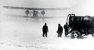
Construction pace was fast, and pilots wishing to become airmail pilots were first exposed to the harsh wintertime work with the crews building the first segments of the lighting system. [1]
By the end of the year, the public anticipated anchored lighted airways across the Atlantic, Pacific, and to China. [2]
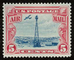
The first nighttime airmail flights started on July 1, 1924. By eliminating the transfer of mail to rail cars at night, the coast to coast delivery time for airmail was reduced by two business days. Eventually, there were 284 beacons in service. [3] With a June 1925 deadline, the 2,665 mile lighted airway was completed from New York to San Francisco. In 1927, the lighted airway was complete between New York City to Salt Lake City, Los Angeles to Las Vegas, Los Angeles to San Francisco, New York to Atlanta, and Chicago to Dallas, 4,121 miles in total. In 1933, the Transcontinental Airway System totaled 1,500 beacons, and 18,000 miles. [4]
The lighted Airway Beacons were a substantial navigation aid in an era prior to the development of radio navigation. However, their effectiveness was limited by visibility and weather conditions.
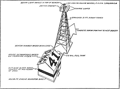
24 inches (610 mm) diameter rotating beacons were mounted on 53-foot (16 m) high towers, and spaced ten miles apart. The spacing was closer in the mountains, and farther apart in the plains. The beacons were five million candlepower, and rotated six times a minute. "Ford beacons" (named after Ford Car headlights) were also used, placing four separate lights at different angles. [5] Airports used green beacons and airways used red beacons. The beacons flashed identification numbers in Morse code. The sequence was "WUVHRKDBGM", which prompted the mnemonic "When Undertaking Very Hard Routes Keep Directions By Good Methods". [6] Engineers believed the variations of beacon height along hills and valleys would allow pilots to see beacons both above ground fog, and below cloud layers.
Towers were built of numbered angle iron sections with concrete footings. Some facilities used concrete arrows pointing in the direction of towers. In areas where no connection to a power grid was available, a generator was housed in a small building. Some buildings also served as weather stations. Many arrow markings were removed during World War II, to prevent aiding enemy bombers in navigation. [7] Nineteen updated beacons remained in service in Montana until 2018, maintained by the Montana Department of Transportation's Aviation Division. [8]
Aviation is the design, development, production, operation, and use of aircraft, especially heavier-than-air aircraft. Articles related to aviation include:

A non-directional beacon (NDB) or non-directional radio beacon is a radio beacon which does not include inherent directional information. Radio beacons are radio transmitters at a known location, used as an aviation or marine navigational aid. NDB are in contrast to directional radio beacons and other navigational aids, such as low-frequency radio range, VHF omnidirectional range (VOR) and tactical air navigation system (TACAN).

Very High Frequency Omnidirectional Range Station (VOR) is a type of short-range radio navigation system for aircraft, enabling aircraft with a receiving unit to determine its position and stay on course by receiving radio signals transmitted by a network of fixed ground radio beacons. It uses frequencies in the very high frequency (VHF) band from 108.00 to 117.95 MHz. Developed in the United States beginning in 1937 and deployed by 1946, VOR became the standard air navigational system in the world, used by both commercial and general aviation, until supplanted by satellite navigation systems such as GPS in the early 21st century. As such, VOR stations are being gradually decommissioned. In 2000 there were about 3,000 VOR stations operating around the world, including 1,033 in the US, but by 2013 the number in the US had been reduced to 967. The United States is decommissioning approximately half of its VOR stations and other legacy navigation aids as part of a move to performance-based navigation, while still retaining a "Minimum Operational Network" of VOR stations as a backup to GPS. In 2015, the UK planned to reduce the number of stations from 44 to 19 by 2020.
The Air Commerce Act of 1926 created an Aeronautic Branch of the United States Department of Commerce. Its functions included testing and licensing of pilots, certification of aircraft and investigation of accidents.

In the United States, airways or air routes are defined by the Federal Aviation Administration (FAA) in two ways:
The Air Mail scandal, also known as the Air Mail fiasco, is the name that the American press gave to the political scandal resulting from a 1934 congressional investigation of the awarding of contracts to certain airlines to carry airmail and the subsequent disastrous use of the U.S. Army Air Corps to fly the mail after the contracts were revoked.

A marker beacon is a particular type of VHF radio beacon used in aviation, usually in conjunction with an instrument landing system (ILS), to give pilots a means to determine position along an established route to a destination such as a runway.
An aerodrome beacon, airport beacon, rotating beacon or aeronautical beacon is a beacon installed at an airport or aerodrome to indicate its location to aircraft pilots at night.
Transcontinental Air Transport (T-A-T) was an airline founded in 1928 by Clement Melville Keys that merged in 1930 with Western Air Express to form what became TWA. Keys enlisted the help of Charles Lindbergh to design a transcontinental network to get government airmail contracts. Lindbergh established numerous airports across the country in this effort.

An airway beacon (US) or aerial lighthouse was a rotating light assembly mounted atop a tower. These were once used extensively in the United States for visual navigation by airplane pilots along a specified airway corridor. In Europe, they were used to guide aircraft with lighted beacons at night.

Willows-Glenn County Airport is a county-owned, public-use airport located one nautical mile (2 km) west of the central business district of Willows, a city in Glenn County, California, United States. This airport is included in the National Plan of Integrated Airport Systems for 2011–2015, which categorized it as a general aviation facility. It is also known as Willows-Glenn Airport.

Ceduna Airport is a public airport in Ceduna, South Australia. The airport, which is owned by the District Council of Ceduna is located adjacent to the Eyre Highway, approximately 2 km (1.2 mi) east of the town. It is the westernmost airport that receives regular passenger service in South Australia and is critical infrastructure for the surrounding remote and sparsely populated region. In addition to scheduled flights to Adelaide, the airport caters to charters in support of the mining industry, general aviation, the Royal Flying Doctor Service, aerial firefighting and occasional military use.

TWA Flight 3 was a twin-engine Douglas DC-3-382 propliner, registration NC1946, operated by Transcontinental and Western Air (TWA) as a scheduled domestic passenger flight from New York, New York, to Burbank, California, in the United States, via several stopovers including Las Vegas, Nevada. On January 16, 1942 at 19:20 PST, fifteen minutes after takeoff from Las Vegas Airport bound for Burbank, the aircraft was destroyed when it crashed into a sheer cliff on Potosi Mountain, 32 miles (51 km) southwest of the airport, at an elevation of 7,770 ft (2,370 m) above sea level. All 22 people on board, including movie star Carole Lombard, her mother, and three crew members, died in the crash. The Civil Aeronautics Board (CAB) investigated the accident and determined that the cause was a navigation error by the captain.

United States airmail was a service class of the United States Post Office Department (USPOD) and its successor United States Postal Service (USPS) delivering air mail by aircraft flown within the United States and its possessions and territories. Letters and parcels intended for air mail service were marked as "Via Air Mail", appropriately franked, and assigned to any then existing class or sub-class of the Air Mail service.

The low-frequency radio range, also known as the four-course radio range, LF/MF four-course radio range, A-N radio range, Adcock radio range, or commonly "the range", was the main navigation system used by aircraft for instrument flying in the 1930s and 1940s, until the advent of the VHF omnidirectional range (VOR), beginning in the late 1940s. It was used for en route navigation as well as instrument approaches and holds.

James Herbert "Jack" Knight was an American pilot who made the first overnight transcontinental air mail delivery. Knight was part of an airmail relay team that flew 2,629 miles across the United States on February 22–23, 1921 in an effort to show that the airmail service was much faster than the railroads. When all the other pilots were weathered-in or broken-down, Knight flew extra relay sections through the night in snow and fog and is credited with saving the airmail service from political decommission. "Jack Knight's Night Flight" made him the most famous pilot in America in the era prior to Charles Lindbergh.

Otto Praeger was the Washington, D.C., postmaster from 1913 to 1915 and was the Second Assistant United States Postmaster General from 1915 to 1921. He was responsible for implementing airmail from 1918 to 1927.

TWA Flight 6963, a scheduled Transcontinental & Western Air flight from Paris Orly Airport to New York City with scheduled stops at Shannon Airport and Gander, crashed on 28 December 1946 about 1.5 kilometres (0.81 nmi) west-northwest of Shannon Airport on the island of Inismacnaughton.
Grover Clinton Tyler was an aeronautical pioneer who flew as an airmail pilot in the 1920s and 1930s, and one of only ten recipients of the Airmail Flyers' Medal of Honor.

The Airway Radio Station in Gallatin County, Montana was built by the Aeronautics Bureau of the U.S. Department of Commerce in 1933. Located on Pogreba Field at Three Forks Airport, the radio station was part of a series of federally-constructed airway stations built during the early years of U.S. civil aviation. The station housed the radio range and ground-to-air radio systems that aided airmail pilots flying on the Minneapolis-Spokane-Seattle civil airway. The station was moved from its original location at Seifert Field, near Belgrade, Montana, to Pogreba Field in 1953, where it now serves as a terminal at Three Forks Airport. The Airway Radio Station was listed on the National Register of Historic Places on November 5, 1998.