U-shaped valley

Last updated
A glaciated valley in the Altai Mountains showing the characteristic U shape. Raspadok. Altai 2011-08avg.JPG
A glaciated valley in the Altai Mountains showing the characteristic U shape.
Malyovitsa U-shaped valley, Rila Mountain, Bulgaria Mal'ovishki tsirkus 4.jpg
Malyovitsa U-shaped valley, Rila Mountain, Bulgaria
U-shaped valley in Leh valley, Ladakh, NW Indian Himalaya. The glacier visible at the head of the valley is the last remnant of the formerly much more extensive glacier which carved it. U-shaped valley at the head of Leh valley, Ladakh.JPG
U-shaped valley in Leh valley, Ladakh, NW Indian Himalaya. The glacier visible at the head of the valley is the last remnant of the formerly much more extensive glacier which carved it.
U-shaped valley with lake in Myklebustdalen, Nordfjord, Sogn og Fjordane, Norway. Myklebustdalen-sanddal-fjordane.jpg
U-shaped valley with lake in Myklebustdalen, Nordfjord, Sogn og Fjordane, Norway.

U-shaped valleys, also called trough valleys or glacial troughs, are formed by the process of glaciation. They are characteristic of mountain glaciation in particular. [1] They have a characteristic U shape in cross-section, with steep, straight sides and a flat or rounded bottom (by contrast, valleys carved by rivers tend to be V-shaped in cross-section). Glaciated valleys are formed when a glacier travels across and down a slope, carving the valley by the action of scouring. [2] When the ice recedes or thaws, the valley remains, often littered with small boulders that were transported within the ice, called glacial till or glacial erratic.

Contents

Examples of U-shaped valleys are found in mountainous regions throughout the world including the Andes, Alps, Caucasus Mountains, Himalaya, Rocky Mountains, New Zealand and the Scandinavian Mountains. They are found also in other major European mountains including the Carpathian Mountains, the Pyrenees, the Rila and Pirin mountains in Bulgaria, and the Scottish Highlands. A classic glacial trough is in Glacier National Park in Montana, USA in which the St. Mary River runs. Another well-known U-shaped valley is the Nant Ffrancon valley in Snowdonia, Wales.

When a U-shaped valley extends into saltwater, becoming an inlet of the sea, it is called a fjord, from the Norwegian word for these features that are common in Norway. Outside of Norway, a classic U-shaped valley that is also a fjord is the Western Brook Pond Fjord in Gros Morne National Park in Newfoundland, Canada.

Formation

Glacier Valley formation Glacier Valley formation- Formacion Valle glaciar.gif
Glacier Valley formation

Shape

Formation of a U-shaped valley happens over geologic time, meaning not during a human's lifespan. It can take anywhere between 10,000 and 100,000 years for a V-shaped valley to be carved into a U-shaped valley. [3] These valleys can be several thousand feet deep and tens of miles long. [1] Glaciers will spread out evenly in open areas, but tend to carve deep into the ground when confined to a valley. [1] Ice thickness is a major contributing factor to valley depth and carving rates. As a glacier moves downhill through a valley, usually with a stream running through it, the shape of the valley is transformed. As the ice melts and retreats, the valley is left with very steep sides and a wide, flat floor. This parabolic shape is caused by glacial erosion removing the contact surfaces with greatest resistance to flow, and the resulting section minimises friction. [4] There are two main variations of this U-shape. The first is called the Rocky Mountain model and it is attributed to alpine glacial valleys, showing an overall deepening effect on the valley. The second variation is referred to as the Patagonia-Antarctica model, attributed to continental ice sheets and displaying an overall widening effect on its surroundings. [4]

Valley floor

The floors of these glacial valleys are where the most evidence can be found regarding glaciation cycles. For the most part, the valley floor is wide and flat, but there are various glacial features that signify periods of ice transgression and regression. The valley can have various steps, known as valley steps, and over-deepenings anywhere from ten to hundreds of meters deep. [3] These then fill in with sediments to create plains or water to create lakes, sometimes referred to as "string-of-pearl" or ribbon lakes. [3] Such water filled U-valley basins are also known as "fjord-lakes" or "valley-lakes" (Norwegian: fjordsjø or dalsjø). Gjende and Bandak lakes in Norway are examples of fjord-lakes. Some of these fjord-lakes are very deep for instance Mjøsa (453 meters) and Hornindalsvatnet (514 m). The longitudinal profile of a U-shaped, glaciated valley is often stepwise where flat basins are interrupted by thresholds. Rivers often dig a V-shaped valley or gorge through the threshold. [5] [6] [7]

Surrounding smaller tributary valleys will often join the main valleys during glaciation periods, leaving behind features known as hanging valleys high in the trough walls after the ice melts.

After deglaciation, snow and ice melt from the mountain tops can create streams and rivers in U-shaped valleys. These are referred to as misfit streams. The streams that form in hanging valleys create waterfalls that flow into the main valley branch. Glacial valleys may also have natural, often dam-like, structures within them, called moraines. They are created due to excess sediment and glacial till moved and deposited by the glacier.

In volcanic mountain ranges, such as the Principal Cordillera of the Andes, glacial valley floors may be covered by thick lava flows. [8]

Trough end

A glacial trough or glaciated mountain valley often ends in an abrupt head known as the 'trough end' or 'trough head'. [9] This may have almost sheer rock walls and spectacular waterfalls. [9] [10] They are believed to have been formed where a number of small glaciers merge to produce a much larger glacier. [9] Examples include: Warnscale Bottom in the Lake District, Yosemite Valley, and the Rottal and Engstlige  [ de ] valleys in Switzerland. [9] [10]

Marine troughs

Glacial troughs also exist as submarine valleys on continental shelves, such as the Laurentian Channel. These geomorphic features significantly influence sediment distribution and biological communities through their modification of current patterns. [11]

History

Geologists did not always believe that glaciers were responsible for U-shaped valleys and other glacial erosional features. Ice is quite soft and it was unbelievable to many that it could be responsible for the severe carving of bedrock characteristic of glacial erosion. German geologist Penck and American geologist Davis were vocal supporters of this unprecedented glacial erosion. [12]

Progress was made in the 1970s and 1980s on the possible mechanisms of glacial erosion and U-shaped valleys via models proposed by various scientists. Numerical models have been created to explain the phenomenon of carving U-shaped valleys. [3]

See also

Related Research Articles

<span class="mw-page-title-main">Glacier</span> Persistent body of ice that is moving under its own weight

A glacier is a persistent body of dense ice that is constantly moving under its own weight. A glacier forms where the accumulation of snow exceeds its ablation over many years, often centuries. It acquires distinguishing features, such as crevasses and seracs, as it slowly flows and deforms under stresses induced by its weight. As it moves, it abrades rock and debris from its substrate to create landforms such as cirques, moraines, or fjords. Although a glacier may flow into a body of water, it forms only on land and is distinct from the much thinner sea ice and lake ice that form on the surface of bodies of water.

<span class="mw-page-title-main">Valley</span> Low area between hills, often with a river running through it

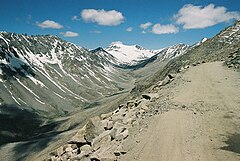
A valley is an elongated low area often running between hills or mountains, which will typically contain a river or stream running from one end to the other. Most valleys are formed by erosion of the land surface by rivers or streams over a very long period. Some valleys are formed through erosion by glacial ice. These glaciers may remain present in valleys in high mountains or polar areas.

<span class="mw-page-title-main">Fjord</span> Long, narrow inlet with steep sides or cliffs, created by glacial activity

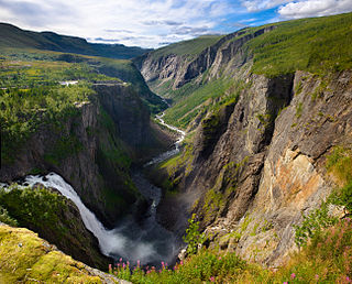
In physical geography, a fjord or fiord is a long, narrow sea inlet with steep sides or cliffs, created by a glacier. Fjords exist on the coasts of Antarctica, the Arctic, and surrounded landmasses of the northern and southern hemispheres. Norway's coastline is estimated to be 29,000 km (18,000 mi) long with its nearly 1,200 fjords, but only 2,500 km (1,600 mi) long excluding the fjords.

<span class="mw-page-title-main">Drumlin</span> Elongated hill formed by glacial action

A drumlin, from the Irish word droimnín, first recorded in 1833, in the classical sense is an elongated hill in the shape of an inverted spoon or half-buried egg formed by glacial ice acting on underlying unconsolidated till or ground moraine. Assemblages of drumlins are referred to as fields or swarms; they can create a landscape which is often described as having a 'basket of eggs topography'.

<span class="mw-page-title-main">Moraine</span> Glacially formed accumulation of debris

A moraine is any accumulation of unconsolidated debris, sometimes referred to as glacial till, that occurs in both currently and formerly glaciated regions, and that has been previously carried along by a glacier or ice sheet. It may consist of partly rounded particles ranging in size from boulders down to gravel and sand, in a groundmass of finely-divided clayey material sometimes called glacial flour. Lateral moraines are those formed at the side of the ice flow, and terminal moraines were formed at the foot, marking the maximum advance of the glacier. Other types of moraine include ground moraines and medial moraines.

<span class="mw-page-title-main">Glaciology</span> Scientific study of ice and natural phenomena involving ice

Glaciology is the scientific study of glaciers, or, more generally, ice and natural phenomena that involve ice.

Landforms are categorized by characteristic physical attributes such as their creating process, shape, elevation, slope, orientation, rock exposure, and soil type.

<span class="mw-page-title-main">Pyramidal peak</span> Angular, sharply pointed mountainous peak

A pyramidal peak, sometimes called a glacial horn in extreme cases, is an angular, sharply pointed mountain peak which results from the cirque erosion due to multiple glaciers diverging from a central point. Pyramidal peaks are often examples of nunataks.

<span class="mw-page-title-main">Cirque</span> An amphitheatre-like valley formed by glacial erosion

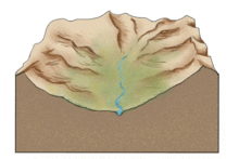
A cirque is an amphitheatre-like valley formed by glacial erosion. Alternative names for this landform are corrie and cwm. A cirque may also be a similarly shaped landform arising from fluvial erosion.

<span class="mw-page-title-main">Glacial landform</span> Landform created by the action of glaciers

Glacial landforms are landforms created by the action of glaciers. Most of today's glacial landforms were created by the movement of large ice sheets during the Quaternary glaciations. Some areas, like Fennoscandia and the southern Andes, have extensive occurrences of glacial landforms; other areas, such as the Sahara, display rare and very old fossil glacial landforms.

<span class="mw-page-title-main">Roche moutonnée</span> Rock formation created by the passing of a glacier

In glaciology, a roche moutonnée is a rock formation created by the passing of a glacier. The passage of glacial ice over underlying bedrock often results in asymmetric erosional forms as a result of abrasion on the "stoss" (upstream) side of the rock and plucking on the "lee" (downstream) side. Some geologists limit the term to features on scales of a metre to several hundred metres and refer to larger features as crag and tail.

<span class="mw-page-title-main">Glaciokarst</span>

Glaciokarst is a geological term that refers to a specific type of karst landscape that been influenced significantly by past glacial activity.

<span class="mw-page-title-main">Plucking (glaciation)</span> Glacial erosion of bedrock

Plucking, also referred to as quarrying, is a glacial phenomenon that is responsible for the weathering and erosion of pieces of bedrock, especially large "joint blocks". This occurs in a type of glacier called a "valley glacier". As a glacier moves down a valley, friction causes the basal ice of the glacier to melt and infiltrate joints (cracks) in the bedrock. The freezing and thawing action of the ice enlarges, widens, or causes further cracks in the bedrock as it changes volume across the ice/water phase transition, gradually loosening the rock between the joints. This produces large pieces of rock called joint blocks. Eventually these joint blocks come loose and become trapped in the glacier.

<span class="mw-page-title-main">Tunnel valley</span> Glacial-formed geographic feature

A tunnel valley is a U-shaped valley originally cut under the glacial ice near the margin of continental ice sheets such as that now covering Antarctica and formerly covering portions of all continents during past glacial ages. They can be as long as 100 km (62 mi), 4 km (2.5 mi) wide, and 400 m (1,300 ft) deep.

Fluvioglacial landforms or glaciofluvial landforms are those that result from the associated erosion and deposition of sediments caused by glacial meltwater. Glaciers contain suspended sediment loads, much of which is initially picked up from the underlying landmass. Landforms are shaped by glacial erosion through processes such as glacial quarrying, abrasion, and meltwater. Glacial meltwater contributes to the erosion of bedrock through both mechanical and chemical processes. Fluvio-glacial processes can occur on the surface and within the glacier. The deposits that happen within the glacier are revealed after the entire glacier melts or partially retreats. Fluvio-glacial landforms and erosional surfaces include: outwash plains, kames, kame terraces, kettle holes, eskers, varves, and proglacial lakes.

<span class="mw-page-title-main">Overdeepening</span> Characteristic of basins and valleys eroded by glaciers

Overdeepening is a characteristic of basins and valleys eroded by glaciers. An overdeepened valley profile is often eroded to depths which are hundreds of metres below the lowest continuous surface line along a valley or watercourse. This phenomenon is observed under modern day glaciers, in salt-water fjords and fresh-water lakes remaining after glaciers melt, as well as in tunnel valleys which are partially or totally filled with sediment. When the channel produced by a glacier is filled with debris, the subsurface geomorphic structure is found to be erosionally cut into bedrock and subsequently filled by sediments. These overdeepened cuts into bedrock structures can reach a depth of several hundred metres below the valley floor.

<span class="mw-page-title-main">Grafton Notch State Park</span> State park in Oxford County, Maine

Grafton Notch State Park is a public recreation area in Grafton Township, Oxford County, Maine. The state park occupies 3,129 acres (1,266 ha) surrounding Grafton Notch, the mountain pass between Old Speck Mountain and Baldpate Mountain, mountains in the Mahoosuc Range. The park is abutted by the eastern and western sections of the Mahoosuc Public Reserved Land, which total 31,807 acres (12,872 ha). The park is managed by the Department of Agriculture, Conservation and Forestry.

<span class="mw-page-title-main">Strandflat</span> Type of landform found in high-latitude areas

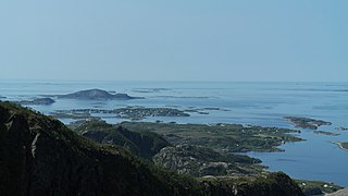
Strandflat is a landform typical of the Norwegian coast consisting of a flattish erosion surface on the coast and near-coast seabed. In Norway, strandflats provide room for settlements and agriculture, constituting important cultural landscapes. The shallow and protected waters of strandflats are valued fishing grounds that provide sustenance to traditional fishing settlements. Outside Norway proper, strandflats can be found in other high-latitude areas, such as Antarctica, Alaska, the Canadian Arctic, the Russian Far North, Greenland, Svalbard, Sweden and Scotland.

<span class="mw-page-title-main">Valley step</span> Prominent change in the longitudinal slope of a valley

A valley step is a prominent change in the longitudinal slope of a valley, mainly in trough valleys formed by glaciers.

<span class="mw-page-title-main">Edaga Arbi Glacials</span> Palaeozoic geological formation in Africa

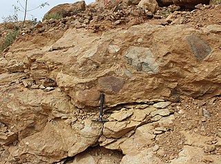
The Edaga Arbi Glacials are a Palaeozoic geological formation in Tigray and in Eritrea. The matrix is composed of grey, black and purple clays, that contains rock fragments up to 6 metres across. Pollen dating yields a Late Carboniferous to Early Permian age.

References

  1. 1 2 3 "glacial valley | geological formation". Encyclopedia Britannica. Retrieved 2017-05-23.
  2. "Glacial Trough/U-Shaped Valley". Illustrated Glossary of Alpine Glacial Landforms. Department of Geography, Central Michigan University. Archived from the original on 27 September 2020. Retrieved 8 August 2019.
  3. 1 2 3 4 Waddington, E. D.; Anderson, S. P.; Anderson, R. S.; MacGregor, K. R. (November 2000). "Geology" . Geology (Boulder). 28 (11): 1031–1034. doi:10.1130/0091-7613(2000)28<1031:NSOGLP>2.0.CO;2. ISSN   0091-7613.
  4. 1 2 "Wiley Online Library". 13. doi:10.1002/esp.3290130805.{{cite journal}}: Cite journal requires |journal= (help)
  5. Karlsen, Ole G. (1981). Delta: naturgeografi for den videregående skolen. Oslo: TANO. ISBN   8251814782.
  6. Hamblin, P. F., & Carmack, E. C. (1978). River‐induced currents in a Fjord Lake. Journal of Geophysical Research: Oceans, 83(C2), 885–899.
  7. Gjessing, Just (1978). Norges landformer. Oslo: Universitetsforl. ISBN   8200017729.
  8. Charrier, Reynaldo; Iturrizaga, Lafasam; Charretier, Sebastién; Regard, Vincent (2019). "Geomorphologic and Glacial Evolution of the Cachapoal and southern Maipo catchments in the Andean Principal Cordillera, Central Chile (34°-35º S)". Andean Geology . 46 (2): 240–278. doi: 10.5027/andgeoV46n2-3108 . Retrieved June 9, 2019.
  9. 1 2 3 4 Blackie, Blackie's Dictionary of Geography, Mumbai: Blackie, 2000, p. 344.
  10. 1 2 Monkhouse, F.J., Dictionary of Geography, London: AldineTransaction, 1970, p.359.
  11. Buhl-Mortensen L, et al. (2012). "51 – Banks, Troughs, and Canyons on the Continental Margin off Lofoten, Vesterålen, and Troms, Norway". Seafloor Geomorphology as Benthic Habitat. pp. 703–715. doi:10.1016/B978-0-12-385140-6.00051-7. ISBN   978-0-12-385140-6.
  12. Bierman; et al. Key Concepts in Geomorphology.