
Brookhaven National Laboratory (BNL) is a United States Department of Energy national laboratory located in Upton, Long Island, and was formally established in 1947 at the site of Camp Upton, a former U.S. Army base and Japanese internment camp. Its name stems from its location within the Town of Brookhaven, approximately 60 miles east of New York City. It is managed by Stony Brook University and Battelle Memorial Institute.

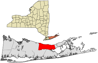
Suffolk County is the easternmost county in the U.S. state of New York. It comprises the eastern two-thirds of Long Island, bordered to its west by Nassau County, to its east by Gardiners Bay and the Atlantic Ocean, to its north by Long Island Sound, and to its south by Great South Bay.

Farmingville is a hamlet and census-designated place (CDP) in the Suffolk County town of Brookhaven, New York, United States. The population was 15,481 at the 2010 census.
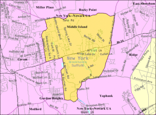
Middle Island is a hamlet and census-designated place (CDP) in the Town of Brookhaven, Suffolk County, New York, United States. The population was 10,483 at the 2010 census. It is situated between the hamlets of Coram and Ridge, to the west and east, respectively, and Rocky Point and Yaphank to the north and south. The name derives from the fact that it lies approximately halfway between the eastern and western ends of Long Island as well as halfway between the northern and southern boundaries.

Miller Place is a hamlet and census-designated place (CDP) in the Town of Brookhaven, Suffolk County, New York, United States, on the North Shore of Long Island. Miller Place has been inhabited since the 17th century and is named for the Miller family that included many of its initial settlers. For most of its history, the community functioned as an agriculture-based society. Despite preserving much of its historic identity, changes in the 20th century have transitioned the hamlet into a desirable and densely populated suburban area. The population was 11,723 at the 2020 census.

Ridge is a hamlet and census-designated place (CDP) in the town of Brookhaven, Suffolk County, New York, United States. The population was 13,336 at the 2010 census.

Wading River is a hamlet and census-designated place (CDP) in Suffolk County, New York, United States, on the North Shore of Long Island. As of the 2010 census, the CDP population was 7,719. It is adjacent to Shoreham and shares a school district.

Yaphank is a hamlet and census-designated place (CDP) in Suffolk County, New York, United States. The population was 5,945 at the time of the 2010 census.

Islip is a town in Suffolk County, New York, United States, on the south shore of Long Island. The population was 335,543 at the 2010 census, making it the fourth most populous city or town in the state.
Riverhead is a town in Suffolk County, New York, United States, on the north shore of Long Island. Since 1727, Riverhead has been the county seat of Suffolk County, though most county offices are in Hauppauge. As of the 2020 census, the population was 35,902. The town rests on the mouth of the Peconic River, from which it derives its name. The smaller hamlet of Riverhead lies within it, and is the town's principal economic center. The town is 166 miles (267 km) southwest of Boston via the Orient Point-New London Ferry, and is 76 miles (123 km) northeast of New York City.

Smithtown is a town in Suffolk County, New York, on the North Shore of Long Island. It is part of the New York metropolitan area. The population was 116,296 at the 2020 Census.

The Town of Brookhaven is a town in Suffolk County on Long Island, New York, United States, the most populous of ten in the county. Part of the New York metropolitan area, it is located approximately 50 miles from Manhattan. It is the largest of the state of New York's 932 towns by area, and the second most populous after the Town of Hempstead in adjacent Nassau County.

New York State Route 112 (NY 112) is a state highway located entirely within the town of Brookhaven in Suffolk County, New York, in the United States. It runs from an intersection with Montauk Highway in the village of Patchogue to a junction with NY 25A in Port Jefferson Station. It is known locally as Medford Avenue in Patchogue and Patchogue Road in Terryville and Port Jefferson Station. The official name for the road outside these areas is "Patchogue–Port Jefferson Road", though it is often signed simply as "Route 112".

New York's 1st congressional district is a congressional district for the United States House of Representatives in eastern Long Island. It includes the eastern two-thirds of Suffolk County, including the northern portion of Brookhaven, as well as the entirety of the towns of Huntington, Smithtown, Riverhead, Southold, Southampton, East Hampton, and Shelter Island. The district encompasses extremely wealthy enclaves such as the Hamptons, middle class suburban towns such as Selden, Centereach and Lake Grove, working-class towns such as Riverhead and rural farming communities such as Mattituck and Jamesport on the North Fork. The district currently is represented by Republican Nick LaLota.

County Route 46 (CR 46) is a major county road in eastern Suffolk County, New York, in the United States. It runs south-to-north from CR 75 in Smith Point County Park to New York State Route 25A (NY 25A) near the border of Shoreham and Wading River. The road is known as the William Floyd Parkway along its entire length, and is named after William Floyd, a Long Island native and a signer of the United States Declaration of Independence. Despite its "parkway" designation within the State of New York, the road is open to commercial vehicles.
Longwood Central School District covers 53 square miles (140 km2) in central Brookhaven Town, Suffolk County, New York, United States. It serves the hamlets of Ridge, Gordon Heights, Middle Island, Coram, and Yaphank, and parts of Shoreham, Shirley, Medford, and Upton. During the 2017–2018 school year, there were 15,833 students enrolled and 2,069 teachers employed at Longwood CSD.
The economy of the State of New York is reflected in its gross state product in 2022 of $2.053 trillion, ranking third in size behind the larger states of California and Texas. If New York State were an independent nation, it would rank as the 10th largest economy in the world. However, in 2019, the multi-state, New York City-centered metropolitan statistical area produced a gross metropolitan product (GMP) of $US2.0 trillion, ranking first nationally by a wide margin and would also rank as the 10th largest GDP in the world.
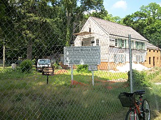
The Davis Town Meeting House is a historic building located in Coram, New York, United States. For most of the 19th century, it served as the town meeting place for the Town of Brookhaven.
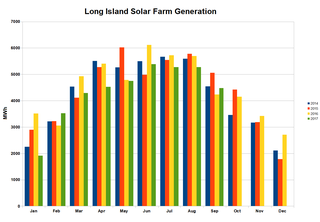
The 32 megawatt AC Long Island Solar Farm (LISF), located in Upton, New York, was the largest photovoltaic array in the eastern U.S. in November 2011. The LISF is made up of 164,312 solar panels from BP Solar which provide enough electricity for roughly 4,500 households. The project will cause the abatement of more than 30,000 metric tons of carbon dioxide emissions per year. LISF is co-owned by BP Solar and MetLife through Long Island Solar Farm LLC. Municipal utility Long Island Power Authority (LIPA) buys the 37-megawatt (49,600 hp) power plant's output, which is estimated at 44 GWh annually, under a 20-year power purchase agreement (PPA). Payments over that time are expected to total $298 million. The project was engineered by Blue Oak Energy and construction subcontracted to Hawkeye LLC from Hauppauge, New York. The plant earned the Best Photovoltaic Project of Year Award from the New York Solar Energy Industries Association. The panels are mounted at a fixed tilt angle of 35°, with the rows spaced approximately 18 ft 4 in (5.59 m) apart.


