Geodesy is the science of measuring and representing the geometry, gravity, and spatial orientation of the Earth in temporally varying 3D. It is called planetary geodesy when studying other astronomical bodies, such as planets or circumplanetary systems.

In geography, latitude is a coordinate that specifies the north–south position of a point on the surface of the Earth or another celestial body. Latitude is given as an angle that ranges from –90° at the south pole to 90° at the north pole, with 0° at the Equator. Lines of constant latitude, or parallels, run east–west as circles parallel to the equator. Latitude and longitude are used together as a coordinate pair to specify a location on the surface of the Earth.
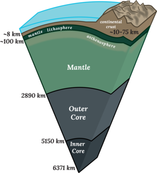
Earth radius is the distance from the center of Earth to a point on or near its surface. Approximating the figure of Earth by an Earth spheroid, the radius ranges from a maximum of nearly 6,378 km (3,963 mi) to a minimum of nearly 6,357 km (3,950 mi).
The geoid is the shape that the ocean surface would take under the influence of the gravity of Earth, including gravitational attraction and Earth's rotation, if other influences such as winds and tides were absent. This surface is extended through the continents. According to Gauss, who first described it, it is the "mathematical figure of the Earth", a smooth but irregular surface whose shape results from the uneven distribution of mass within and on the surface of Earth. It can be known only through extensive gravitational measurements and calculations. Despite being an important concept for almost 200 years in the history of geodesy and geophysics, it has been defined to high precision only since advances in satellite geodesy in the late 20th century.

Physical geodesy is the study of the physical properties of Earth's gravity and its potential field, with a view to their application in geodesy.
The World Geodetic System (WGS) is a standard used in cartography, geodesy, and satellite navigation including GPS. The current version, WGS 84, defines an Earth-centered, Earth-fixed coordinate system and a geodetic datum, and also describes the associated Earth Gravitational Model (EGM) and World Magnetic Model (WMM). The standard is published and maintained by the United States National Geospatial-Intelligence Agency.
Figure of the Earth is a term of art in geodesy that refers to the size and shape used to model Earth. The size and shape it refers to depend on context, including the precision needed for the model. A sphere is a well-known historical approximation of the figure of the Earth that is satisfactory for many purposes. Several models with greater accuracy have been developed so that coordinate systems can serve the precise needs of navigation, surveying, cadastre, land use, and various other concerns.

The National Geodetic Survey (NGS) is a United States federal agency based in Washington, D.C. that defines and manages a national coordinate system, providing the foundation for transportation and communication, mapping and charting, and a large number of science and engineering applications. Since its founding in 1970, it has been part of the National Oceanic and Atmospheric Administration (NOAA), a division within the United States Department of Commerce.
A geodetic datum or geodetic system is a global datum reference or reference frame for precisely representing the position of locations on Earth or other planetary bodies by means of geodetic coordinates. Datums are crucial to any technology or technique based on spatial location, including geodesy, navigation, surveying, geographic information systems, remote sensing, and cartography. A horizontal datum is used to measure a location across the Earth's surface, in latitude and longitude or another coordinate system; a vertical datum is used to measure the elevation or depth relative to a standard origin, such as mean sea level (MSL). Since the rise of the global positioning system (GPS), the ellipsoid and datum WGS 84 it uses has supplanted most others in many applications. The WGS 84 is intended for global use, unlike most earlier datums.

Arc measurement, sometimes degree measurement, is the astrogeodetic technique of determining of the radius of Earth – more specifically, the local Earth radius of curvature of the figure of the Earth – by relating the latitude difference and the geographic distance surveyed between two locations on Earth's surface. The most common variant involves only astronomical latitudes and the meridian arc length and is called meridian arc measurement; other variants may involve only astronomical longitude or both geographic coordinates . Arc measurement campaigns in Europe were the precursors to the International Association of Geodesy (IAG).
Geodetic astronomy or astronomical geodesy (astro-geodesy) is the application of astronomical methods into geodetic networks and other technical projects of geodesy.

A zenith camera is an astrogeodetic telescope used today primarily for the local surveys of Earth's gravity field. Zenith cameras are designed as transportable field instruments for the direct observation of the plumb line and vertical deflections.
The orthometric height is the vertical distance H along the plumb line from a point of interest to a reference surface known as the geoid, the vertical datum that approximates mean sea level. Orthometric height is one of the scientific formalizations of a laypersons' "height above sea level", along with other types of heights in Geodesy.
Mikhail Sergeevich Molodenskii was a Soviet physical geodesist. He was once said to be "probably the only geodesist who would have deserved a Nobel prize".

The North American Datum (NAD) is the horizontal datum now used to define the geodetic network in North America. A datum is a formal description of the shape of the Earth along with an "anchor" point for the coordinate system. In surveying, cartography, and land-use planning, two North American Datums are in use for making lateral or "horizontal" measurements: the North American Datum of 1927 (NAD 27) and the North American Datum of 1983 (NAD 83). Both are geodetic reference systems based on slightly different assumptions and measurements.
The Bessel ellipsoid is an important reference ellipsoid of geodesy. It is currently used by several countries for their national geodetic surveys, but will be replaced in the next decades by modern ellipsoids of satellite geodesy.
An Earth ellipsoid or Earth spheroid is a mathematical figure approximating the Earth's form, used as a reference frame for computations in geodesy, astronomy, and the geosciences. Various different ellipsoids have been used as approximations.

Irene Kaminka Fischer was an Austrian-American mathematician and geodesist. She was a member of the National Academy of Engineering, a Fellow of the American Geophysical Union, and inductee of the National Imagery and Mapping Agency Hall of Fame. Fischer became one of two internationally known women scientists in the field of geodesy during the golden age of the Project Mercury and the Apollo program. Her Mercury datum, as well as her work on the lunar parallax, were instrumental in conducting these missions. "In his preface to the ACSM publication, Fischer's former colleague, Bernard Chovitz, referred to her as one of the most renowned geodesists of the third quarter of the twentieth century. Yet this fact alone makes her one of the most renowned geodesists of all times, because, according to Chovitz, the third quarter of the twentieth century witnessed "the transition of geodesy from a regional to a global enterprise."

Carlos Ibáñez e Ibáñez de Ibero, 1st Marquis of Mulhacén, was a Spanish divisional general and geodesist. He represented Spain at the 1875 Conference of the Metre Convention and was the first president of the International Committee for Weights and Measures. As a forerunner geodesist and president of the International Geodetic Association, he played a leading role in the worldwide dissemination of the metric system. His activities resulted in the distribution of a platinum and iridium prototype of the metre to all States parties to the Metre Convention during the first meeting of the General Conference on Weights and Measures in 1889. These prototypes defined the metre right up until 1960.