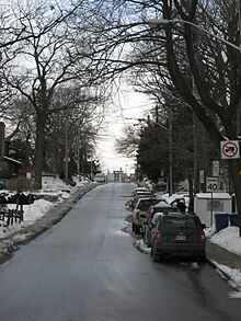
The Beaches is a neighbourhood in Toronto, Ontario, Canada. It is so named because of its four beaches situated on Lake Ontario. It is located east of downtown within the "Old" City of Toronto. The approximate boundaries of the neighbourhood are from Victoria Park Avenue on the east to Kingston Road on the north, along Dundas Street to Coxwell Avenue on the west, south to Lake Ontario. The Beaches is part of the east-central district of Toronto.

Gerrard Street is a street in Toronto, Ontario, Canada. It consists of two separate parts, historically referred to as Lower Gerrard and Upper Gerrard. The former stretches between University Avenue and Coxwell Avenue for 6 km, across Old Toronto. The latter portion starts 300 m north of Lower Gerrard's eastern terminus and runs between Coxwell Avenue and Clonmore Drive, between Victoria Park Avenue and Warden Avenue, in Scarborough for another 4 km.

Finch Avenue is an arterial thoroughfare that travels east–west in Toronto, Ontario, Canada. The road continues west into the Regional Municipality of Peel as Regional Road 2 and east into the Regional Municipality of Durham as Regional Road 37.

The cancelled expressways in Toronto were a planned series of expressways in Toronto, Ontario, Canada that were only partially built or cancelled due to public opposition. The system of expressways was intended to spur or handle growth in the suburbs of Toronto, but were opposed by citizens within the city of Toronto proper, citing the demolition of homes and park lands, air pollution, noise and the high cost of construction. The Spadina Expressway, planned since the 1940s, was cancelled in 1971 after being only partially constructed. After the Spadina cancellation, other expressway plans, intended to create a 'ring' around the central core, were abandoned.

Lawrence Avenue is a major east-west thoroughfare in Toronto, Ontario, Canada. It is divided into east and west portions by Yonge Street, the dividing line of east-west streets in Toronto.
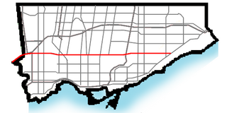
Eglinton Avenue is a major east–west arterial thoroughfare in Toronto and Mississauga in the Canadian province of Ontario. The street begins at Highway 407 at the western limits of Mississauga, as a continuation of Lower Baseline in Milton. It traverses the midsection of both cities and ends at Kingston Road. Eglinton Avenue is the only street to cross all six former boroughs of Metropolitan Toronto that became amalgamated into the modern megacity in 1998.

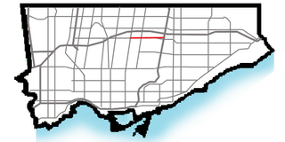
Sheppard Avenue is an east–west principal arterial road in Toronto, Ontario, Canada. The street has two distinct branches near its eastern end, with the original route being a collector road leading to Pickering via a turnoff, and the main route following a later-built roadway which runs south to Kingston Road. To avoid name duplication, the Toronto portion of the northern branch was renamed Twyn Rivers Drive. The section of the street entirely in Toronto is (34.2 km) in length, while the Pickering section and Twyn Rivers Dr. is (5.4 km) long.

Steeles Avenue is an east–west street that forms the northern city limit of Toronto and the southern limit of York Region in Ontario, Canada. It stretches 77.3 km (48.0 mi) across the western and central Greater Toronto Area from Appleby Line in Milton in the west to the Toronto-Pickering city limits in the east, where it continues east into Durham Region as Taunton Road, which itself extends 58 km (36 mi) across the length of Durham Region to its boundary with Northumberland County.

Danforth Avenue and Danforth Road are two historically-related arterial streets in Toronto, Ontario, Canada. Danforth Avenue is an east-west street that begins in Old Toronto at the Prince Edward Viaduct as a physical continuation of Bloor Street and continues for about 6 kilometres (3.7 mi) east through old Toronto, about 350 metres (1,150 ft) of old East York, and a further 5 kilometres (3.1 mi) in Scarborough until it intersects with Kingston Road via a ramped interchange. Danforth Road splits off the Avenue west of Warden Avenue and runs diagonally northeast until south of Lawrence Avenue, where it continues as McCowan Road.
York Mills Road is an east-west route in Toronto, Ontario, Canada named for the historic village of York Mills that was located on the hill immediately north of today's intersection of York Mills Road and Yonge Street. The village of York Mills is distinguished from the 1920s subdivision to the south known as Hoggs Hollow. "York" refers to York Township and "Mills" refers to the gristmills and sawmills that once operated (1804–1926) in the valley through which the Don River runs.
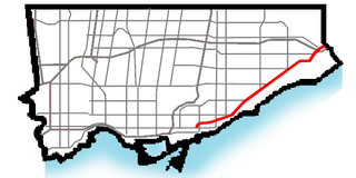
Kingston Road is a major arterial road in Toronto and Durham Region, Ontario. It the southernmost major (mainly) east-west road in the eastern portion of Toronto, specifically in the district of Scarborough, and runs east to Ajax in Durham. Until 1998, it formed a portion of Highway 2. The name of the street is derived from Kingston, Ontario as the road was the primary route used to travel from Toronto to the settlements east of it situated along the shores of Lake Ontario; in the west end of Kingston, the road was referred to as the York Road until at least 1908, and is today named Princess Street.

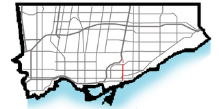
Brimley Road is a north-south street in Toronto and the Regional Municipality of York, Ontario, Canada. In Toronto, it is located entirely within Scarborough and carried 32000 vehicles daily in May 2007 Hence, it is classified as a major arterial road by the city of Toronto.

Toronto and Scarboro' Electric Railway, Light and Power Company was established in August 1892 to provide street railway service to the Upper Beaches district within the City of Toronto, Ontario and to the neighbouring Township of Scarborough. Except for two branches, the line ran as a radial along Kingston Road.
The Eglinton East LRT (EELRT), also known as Line 7 Eglinton East and formerly known as the Scarborough Malvern LRT, is a proposed light rail line in Toronto, Ontario, Canada. The line would be entirely within the district of Scarborough. It was originally part of Transit City, a plan to develop new light rail lines along several priority transit corridors in the city.
Greensborough(Census Tract Number 5350403.03) is a community in the city of Markham in the Regional Municipality of York in the Canadian province of Ontario.
Woodbine Avenue is a north–south arterial road consisting of two sections in Toronto and York Region in Ontario, Canada.