Viking 2

Last updated

47°38′N225°43′W / 47.64°N 225.71°W / 47.64; -225.71 (Viking 2 lander) [1]
Viking 2
Viking spacecraft.jpg
Viking Orbiter
Mission typeOrbiter and Lander
Operator NASA
COSPAR ID
SATCAT no.
  • Orbiter: 8199
  • Lander: 9408
Website Viking Project Information
Mission durationOrbiter: 1050 days  (1022 sol) [1]
Lander: 1316 days  (1281 sol) [1]
Launch to last contact: 1,676 days
Spacecraft properties
ManufacturerOrbiter: JPL
Lander: Martin Marietta
Launch mass3,530 kg [lower-alpha 1]
Dry massOrbiter: 883 kg (1,947 lb)
Lander: 572 kg (1,261 lb) [2]
PowerOrbiter: 620 W
Lander: 70 W
Start of mission
Launch date18:39,September 9, 1975(UTC) (1975-09-09T18:39Z) [1] [3]
Rocket Titan IIIE with Centaur upper stage
Launch site LC-41, Cape Canaveral
End of mission
Last contactApril 12, 1980 (1980-04-12) [4]
Orbital parameters
Reference system Areocentric
Mars orbiter
Spacecraft componentViking 2 Orbiter
Orbital insertionAugust 7, 1976 [1] [3]
Orbital parameters
Periareion altitude 302 km (188 mi)
Apoareion altitude 33,176 km (20,615 mi)
Inclination80.5°
  Viking 1
Voyager 2  
 

The Viking 2 mission was part of the American Viking program to Mars, and consisted of an orbiter and a lander essentially identical to that of the Viking 1 mission. [1] Viking 2 was operational on Mars for 1281 sols (1,316 days; 3 years, 221 days). The Viking 2 lander operated on the surface for 1,316 days, or 1281 sols, and was turned off on April 12, 1980, when its batteries failed. The orbiter worked until July 25, 1978, [1] returning almost 16,000 images in 706 orbits around Mars. [5]

Contents

Mission profile

The craft was launched on September 9, 1975. Following launch using a Titan/Centaur launch vehicle and a 333-day cruise to Mars, the Viking 2 Orbiter began returning global images of Mars prior to orbit insertion. The orbiter was inserted into a 1,500 x 33,000 km, 24.6 h Mars orbit on August 7, 1976, and trimmed to a 27.3 h site certification orbit with a periapsis of 1,499 km and an inclination of 55.2 degrees on August 9. The orbiter then began taking photographs of candidate landing sites, which were used to select the final landing site. [6]

The lander separated from the orbiter on September 3, 1976, at 22:37:50 UT and landed at Utopia Planitia. The normal procedure called for the structure connecting the orbiter and lander (the bioshield) to be ejected after separation. However, due to problems with the separation process, the bioshield remained attached to the orbiter. The orbit inclination was raised to 75 degrees on September 30, 1976.

Orbiter

The orbiter's primary mission ended on October 5, 1976, at the beginning of solar conjunction. The extended mission commenced on December 14, 1976, after the solar conjunction. On December 20, 1976, the periapsis was lowered to 778 km, and the inclination raised to 80 degrees.

Operations included close approaches to Deimos in October 1977, and the periapsis was lowered to 300 km and the period changed to 24 hours on October 23, 1977. The orbiter developed a leak in its propulsion system that vented its attitude control gas. It was placed in a 302 × 33,176 km orbit and turned off on July 25, 1978, after returning almost 16,000 images in about 700–706 orbits around Mars.

Lander

Proof test article of the Viking Mars Lander NASM-A19790215000-NASM2016-02690.jpg
Proof test article of the Viking Mars Lander

The lander and its aeroshell separated from the orbiter on September 3, 1976, at 19:39:59 UT. At the time of separation, the lander was orbiting at about 4 km/s. After separation, rockets fired to begin lander deorbit. After a few hours, at about 300 km attitude, the lander was reoriented for entry. The aeroshell with its ablative heat shield slowed the craft as it plunged through the atmosphere.

Photo of the Viking 2 lander taken by the Mars Reconnaissance Orbiter in 2006 PSP 001501 2280 RED VL-2 lander.png
Photo of the Viking 2 lander taken by the Mars Reconnaissance Orbiter in 2006

The Viking 2 lander touched down about 200 km west of the crater Mie in Utopia Planitia at 48°16′08″N225°59′24″W / 48.269°N 225.990°W / 48.269; -225.990 at an altitude of -4.23 km relative to a reference ellipsoid with an equatorial radius of 3,397.2 km and a flattening of 0.0105 ( 47°58′01″N225°44′13″W / 47.967°N 225.737°W / 47.967; -225.737 (Viking 2 landing site planetographic) planetographic longitude) at 22:58:20 UT (9:49:05 a.m. local Mars time).

Approximately 22 kg (49 lb) of propellants were left at landing. Due to radar misidentification of a rock or highly reflective surface, the thrusters fired an extra time 0.4 seconds before landing, cracking the surface and raising dust. The lander settled down with one leg on a rock, tilted at 8.2 degrees. The cameras began taking images immediately after landing.

The Viking 2 lander was powered by radioisotope generators and operated on the surface until its batteries failed on April 12, 1980.

In July 2001, the Viking 2 lander was renamed the Gerald Soffen Memorial Station after Gerald Soffen (1926–2000), the project scientist of the Viking program. [6] [7]

Results from the Viking 2 mission

Landing site soil analysis

The regolith, referred to often as "soil," resembled those produced from the weathering of basaltic lavas. The tested soil contained abundant silicon and iron, along with significant amounts of magnesium, aluminum, sulfur, calcium, and titanium. Trace elements, strontium and yttrium, were detected.

The amount of potassium was one-fifth of the average for the Earth's crust. Some chemicals in the soil contained sulfur and chlorine that were like those remaining after the evaporation of seawater. Sulfur was more concentrated in the crust on top of the soil than in the bulk soil beneath.

The sulfur may be present as sulfates of sodium, magnesium, calcium, or iron. A sulfide of iron is also possible. [8] The Spirit rover and the Opportunity rover both found sulfates on Mars. [9]

Minerals typical weathering products of mafic igneous rocks were found. [10] All samples heated in the gas chromatograph-mass spectrometer (GCMS) gave off water.

However, the way the samples were handled prohibited an exact measurement of the amount of water. But, it was around 1%. [11] Studies with magnets aboard the landers indicated that the soil is between 3 and 7 percent magnetic materials by weight. The magnetic chemicals could be magnetite and maghemite, which could come from the weathering of basalt rock. [12] [13] Subsequent experiments carried out by the Mars Spirit rover (landed in 2004) suggest that magnetite could explain the magnetic nature of the dust and soil on Mars. [14]

Mars Viking 22a002.png
Viking 2 lander image of Utopia Planitia.

Search for life

Viking 2 carried a biology experiment whose purpose was to look for life. The Viking 2 biology experiment weighed 15.5 kg (34 lb) and consisted of three subsystems: the Pyrolytic Release experiment (PR), the Labeled Release experiment (LR), and the Gas Exchange experiment (GEX). In addition, independent of the biology experiments, Viking 2 carried a Gas Chromatograph/Mass Spectrometer (GCMS) that could measure the composition and abundance of organic compounds in the Martian soil. [15]

The results were Unusual and conflicting: the GCMS and GEX gave negative results, while the PR and LR gave positive results. [16] Viking scientist Patricia Straat stated in 2009, "Our (LR) experiment was a definite positive response for life, but a lot of people have claimed that it was a false positive for a variety of reasons." [17]

Many scientists believe that the data results were attributed to inorganic chemical reactions in the soil. However, this view may be changing due to a variety of discoveries and studies since Viking. These include the discovery of near-surface ice near the Viking landing zone, the possibility of perchlorate destruction of organic matter, and the reanalysis of GCMS data by scientists in 2018. [18] Some scientists still believe the results were due to living reactions. The formal declaration at the time of the mission was that the discovery of organic chemicals was inconclusive.[ citation needed ]

Mars has almost no ozone layer, unlike the Earth, so UV light sterilizes the surface and produces highly reactive chemicals such as peroxides that would oxidize any organic chemicals. [19] The Phoenix Lander discovered the chemical perchlorate in the Martian soil. Perchlorate is a powerful oxidizing agent, which could have eradicated any organic material on the surface. [20] Perchlorate is now considered widespread on Mars, making it hard to detect any organic compounds on the Martian surface. [21]

Viking Lander 2 Camera 1 NOON HIGH RESOLUTION COLOR MOSAIC.jpg
Viking 2 lander Camera 1 NOON HIGH RESOLUTION MOSAIC (With Low Resolution Color).
22i103-104-105-109 FROST.jpg
Viking 2 Lander Camera 2 FROST (Low Resolution Color) Sol 1028, 1030 and 1050 between 11:34 and 12:40.

Orbiter results

Viking program

The Viking Orbiters led to significant discoveries about the presence of water on Mars. Huge river valleys were found in many areas. They showed that water floods carved deep valleys, eroded grooves into bedrock, and traveled thousands of kilometers. In the southern hemisphere, the presence of branched stream areas suggests that there was once rainfall. [22] [23] [24]

The images below are mosaics of many small, high-resolution images.

Location

Interactive image map of the global topography of Mars, overlaid with the position of Martian rovers and landers. Coloring of the base map indicates relative elevations of Martian surface.
Clickable image: Clicking on the labels will open a new article.
Legend:
.mw-parser-output .legend{page-break-inside:avoid;break-inside:avoid-column}.mw-parser-output .legend-color{display:inline-block;min-width:1.25em;height:1.25em;line-height:1.25;margin:1px 0;text-align:center;border:1px solid black;background-color:transparent;color:black}.mw-parser-output .legend-text{}
Active (white lined, *) *
Inactive *
Planned (dash lined, ***)
(view * discuss) Mars Map.JPG
Interactive image map of the global topography of Mars, overlaid with the position of Martian rovers and landers. Coloring of the base map indicates relative elevations of Martian surface.
Mano cursor.svg Clickable image:Clicking on the labels will open a new article.
Legend:   Active (white lined, ※)  Inactive  Planned (dash lined, ⁂)
PhoenixIcon.png Beagle 2
CuriosityIcon.png
Curiosity
PhoenixIcon.png
Deep Space 2
RoverIcon.png Rosalind Franklin
PhoenixIcon.png InSight
Mars3landericon.jpg Mars 2
Mars3landericon.jpg Mars 3
Mars3landericon.jpg Mars 6
PhoenixIcon.png
Mars Polar Lander ↓
RoverIcon.png Opportunity
CuriosityIcon.png
Perseverance
PhoenixIcon.png Phoenix
EDMIcon.png
Schiaparelli EDM
SojournerIcon.png Sojourner
RoverIcon.png
Spirit
ZhurongIcon.jpg Zhurong
VikingIcon.png
Viking 1
VikingIcon.png Viking 2

See also

Notes

  1. "fully fueled orbiter-lander pair" [2]

Related Research Articles

<span class="mw-page-title-main">Viking program</span> Pair of NASA landers and orbiters sent to Mars in 1976

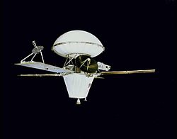
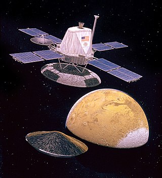
The Viking program consisted of a pair of identical American space probes, Viking 1 and Viking 2, which landed on Mars in 1976. The mission effort began in 1968 and was managed by the NASA Langley Research Center. Each spacecraft was composed of two main parts: an orbiter designed to photograph the surface of Mars from orbit, and a lander designed to study the planet from the surface. The orbiters also served as communication relays for the landers once they touched down.

<i>Viking 1</i> Robotic spacecraft sent to Mars

Viking 1 was the first of two spacecraft, along with Viking 2, each consisting of an orbiter and a lander, sent to Mars as part of NASA's Viking program. The lander touched down on Mars on July 20, 1976, the first successful Mars lander in history. Viking 1 operated on Mars for 2,307 days or 2245 Martian solar days, the longest Mars surface mission until the record was broken by the Opportunity rover on May 19, 2010.

<span class="mw-page-title-main">Utopia Planitia</span> Impact basin on Mars

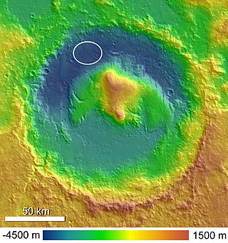
Utopia Planitia is a large plain within Utopia, the largest recognized impact basin on Mars and in the Solar System with an estimated diameter of 3,300 km (2,100 mi). It is the Martian region where the Viking 2 lander touched down and began exploring on September 3, 1976, and the Zhurong rover touched down on May 14, 2021, as a part of the Tianwen-1 mission. It is located at the antipode of Argyre Planitia, centered at 46.7°N 117.5°E. It is also in the Casius quadrangle, Amenthes quadrangle, and the Cebrenia quadrangle of Mars.

<i>Phoenix</i> (spacecraft) NASA Mars lander

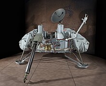
Phoenix was an uncrewed space probe that landed on the surface of Mars on May 25, 2008, and operated until November 2, 2008. Phoenix was operational on Mars for 157 sols. Its instruments were used to assess the local habitability and to research the history of water on Mars. The mission was part of the Mars Scout Program; its total cost was $420 million, including the cost of launch.

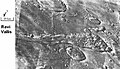
Vallis or valles is the Latin word for valley. It is used in planetary geology to name landform features on other planets.

<span class="mw-page-title-main">Viking lander biological experiments</span> Mars life detection experiments

In 1976 two identical Viking program landers each carried four types of biological experiments to the surface of Mars. The first successful Mars landers, Viking 1 and Viking 2, then carried out experiments to look for biosignatures of microbial life on Mars. The landers each used a robotic arm to pick up and place soil samples into sealed test containers on the craft.

<span class="mw-page-title-main">Chryse Planitia</span> Planitia on Mars

Chryse Planitia is a smooth circular plain in the northern equatorial region of Mars close to the Tharsis region to the west, centered at 28.4°N 319.7°E. Chryse Planitia lies partially in the Lunae Palus quadrangle, partially in the Oxia Palus quadrangle, partially in the Mare Acidalium quadrangle. It is 1600 km or 994 mi in diameter and with a floor 2.5 km below the average planetary surface altitude, and has been suggested to be an ancient buried impact basin, though this is contested. It has several features in common with lunar maria, such as wrinkle ridges. The density of impact craters in the 100 to 2,000 metres range is close to half the average for lunar maria.

<span class="mw-page-title-main">Memnonia quadrangle</span> Map of Mars

The Memnonia quadrangle is one of a series of 30 quadrangle maps of Mars used by the United States Geological Survey (USGS) Astrogeology Research Program. The Memnonia quadrangle is also referred to as MC-16.

<span class="mw-page-title-main">Mars landing</span> Landing of a spacecraft on the surface of Mars

A Mars landing is a landing of a spacecraft on the surface of Mars. Of multiple attempted Mars landings by robotic, uncrewed spacecraft, ten have had successful soft landings. There have also been studies for a possible human mission to Mars including a landing, but none have been attempted.

<span class="mw-page-title-main">Mare Boreum quadrangle</span> Map of Mars

The Mare Boreum quadrangle is one of a series of 30 quadrangle maps of Mars used by the United States Geological Survey (USGS) Astrogeology Research Program. The Mare Boreum quadrangle is also referred to as MC-1. Its name derives from an older name for a feature that is now called Planum Boreum, a large plain surrounding the polar cap.

<span class="mw-page-title-main">Cebrenia quadrangle</span> One of 30 quadrangle maps of Mars used by the US Geological Survey

The Cebrenia quadrangle is one of a series of 30 quadrangle maps of Mars used by the United States Geological Survey (USGS) Astrogeology Research Program. The quadrangle is located in the northeastern portion of Mars' eastern hemisphere and covers 120° to 180° east longitude and 30° to 65° north latitude. The quadrangle uses a Lambert conformal conic projection at a nominal scale of 1:5,000,000 (1:5M). The Cebrenia quadrangle is also referred to as MC-7. It includes part of Utopia Planitia and Arcadia Planitia. The southern and northern borders of the Cebrenia quadrangle are approximately 3,065 km (1,905 mi) and 1,500 km (930 mi) wide, respectively. The north to south distance is about 2,050 km (1,270 mi). The quadrangle covers an approximate area of 4.9 million square km, or a little over 3% of Mars' surface area.

<span class="mw-page-title-main">Diacria quadrangle</span> Map of Mars

The Diacria quadrangle is one of a series of 30 quadrangle maps of Mars used by the United States Geological Survey (USGS) Astrogeology Research Program. The quadrangle is located in the northwestern portion of Mars' western hemisphere and covers 180° to 240° east longitude and 30° to 65° north latitude. The quadrangle uses a Lambert conformal conic projection at a nominal scale of 1:5,000,000 (1:5M). The Diacria quadrangle is also referred to as MC-2. The Diacria quadrangle covers parts of Arcadia Planitia and Amazonis Planitia.

<span class="mw-page-title-main">Amenthes quadrangle</span> Map of Mars

The Amenthes quadrangle is one of a series of 30 quadrangle maps of Mars used by the United States Geological Survey (USGS) Astrogeology Research Program. The Amenthes quadrangle is also referred to as MC-14. The quadrangle covers the area from 225° to 270° west longitude and from 0° to 30° north latitude on Mars. Amenthes quadrangle contains parts of Utopia Planitia, Isidis Planitia, Terra Cimmeria, and Tyrrhena Terra.

<span class="mw-page-title-main">Lunae Palus quadrangle</span> Quadrangle map of Mars

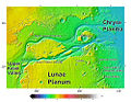
The Lunae Palus quadrangle is one of a series of 30 quadrangle maps of Mars used by the United States Geological Survey (USGS) Astrogeology Research Program. The quadrangle is also referred to as MC-10. Lunae Planum and parts of Xanthe Terra and Chryse Planitia are found in the Lunae Palus quadrangle. The Lunae Palus quadrangle contains many ancient river valleys.

<span class="mw-page-title-main">Oxia Palus quadrangle</span> Map of Mars

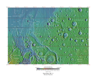
The Oxia Palus quadrangle is one of a series of 30 quadrangle maps of Mars used by the United States Geological Survey (USGS) Astrogeology Research Program. The Oxia Palus quadrangle is also referred to as MC-11.

<span class="mw-page-title-main">Margaritifer Sinus quadrangle</span> One of a series of 30 quadrangle maps of Mars

The Margaritifer Sinus quadrangle is one of a series of 30 quadrangle maps of Mars used by the United States Geological Survey (USGS) Astrogeology Research Program. The Margaritifer Sinus quadrangle is also referred to as MC-19. The Margaritifer Sinus quadrangle covers the area from 0° to 45° west longitude and 0° to 30° south latitude on Mars. Margaritifer Sinus quadrangle contains Margaritifer Terra and parts of Xanthe Terra, Noachis Terra, Arabia Terra, and Meridiani Planum.

<span class="mw-page-title-main">Maja Valles</span> Valles on Mars

The Maja Valles are a large system of ancient outflow channels in the Lunae Palus quadrangle on Mars. Their location is 12.6° north latitude and 58.3° west longitude. The name is a Nepali word for "Mars". The Maja Valles begin at Juventae Chasma. Parts of the system have been partially buried by thin volcanic debris. The channels end at Chryse Planitia.

<span class="mw-page-title-main">Kasei Valles</span> Valles on Mars

The Kasei Valles are a giant system of canyons in Mare Acidalium and Lunae Palus quadrangles on Mars, centered at 24.6° north latitude and 65.0° west longitude. They are 1,580 km (980 mi) long and were named for the word for "Mars" in Japanese. This is one of the largest outflow channel systems on Mars.

To date, interplanetary spacecraft have provided abundant evidence of water on Mars, dating back to the Mariner 9 mission, which arrived at Mars in 1971. This article provides a mission by mission breakdown of the discoveries they have made. For a more comprehensive description of evidence for water on Mars today, and the history of water on that planet, see Water on Mars.

<span class="mw-page-title-main">Aeolis Palus</span> Palus on Mars

Aeolis Palus is a plain between the northern wall of Gale crater and the northern foothills of Aeolis Mons on Mars. It is located at 4.47°S 137.42°E.

References

  1. 1 2 3 4 5 6 7 8 Williams, David R. (December 18, 2006). "Viking Mission to Mars". NASA . Retrieved February 2, 2014.
  2. 1 2 "Viking 2 Lander". National Space Science Data Center.
  3. 1 2 Nelson, Jon. "Viking 2". NASA . Retrieved February 2, 2014.
  4. NASA.gov
  5. "Viking 2 Orbiter". National Space Science Data Center . Retrieved August 16, 2019.
  6. 1 2 "In Depth: Viking 2". NASA Science – Solar System Exporation. NASA.
  7. Malik, Tariq (August 22, 2012). "Mars Rover Landing Site Named for Sci-Fi Icon Ray Bradbury". Space.com.
  8. Clark, B. et al. 1976. Inorganic Analysis of Martian Samples at the Viking Landing Sites. Science: 194. 1283–1288.
  9. Mars Exploration Rover Mission: Press Release Images: Opportunity
  10. Baird, A. et al. 1976. Mineralogic and Petrologic Implications of Viking Geochemical Results From Mars: Interim Report. Science: 194. 1288–1293.
  11. Arvidson, R et al. 1989. The Martian surface as Imaged, Sampled, and Analyzed by the Viking Landers. Reviews of Geophysics:27. 39-60.
  12. Hargraves, R. et al. 1976. Viking Magnetic Properties Investigation: Further Results. Science: 194. 1303–1309.
  13. Arvidson, R, A. Binder, and K. Jones. The Surface of Mars. Scientific American
  14. Bertelsen, P. et al. 2004. Magnetic Properties Experiments on the Mars Exploration rover Spirit at Gusev Crater. Science: 305. 827–829.
  15. Life on Mars Archived October 20, 2014, at the Wayback Machine
  16. Viking Data May Hide New Evidence For Life. Barry E. DiGregorio, July 16, 2000.
  17. Viking 2 Likely Came Close to Finding H2O. Archived September 30, 2009, at the Wayback Machine
  18. Guzman, Melissa; Mckay, Christopher; Quinn, Richard; Szopa, Cyril; Davila, Alfonso; Navarro-Gonzalez, Rafael; Freissinet, Caroline (2018). "Identification of chlorobenzene in the Viking gas chromatograph-mass spectrometer data sets: Reanalysis of Viking mission data consistent with aromatic organic compounds on Mars". Journal of Geophysical Research: Planets. 123 (7): 1674–1683. Bibcode:2018JGRE..123.1674G. doi:10.1029/2018JE005544. S2CID   133854625.
  19. Hartmann, W. 2003. A Traveler's Guide to Mars. Workman Publishing. NY NY.
  20. Alien Rumors Quelled as NASA Announces Phoenix Perchlorate Discovery. Archived September 4, 2010, at the Wayback Machine A.J.S. Rayl, August 6, 2008.
  21. Chang, Kenneth (October 1, 2013). "Hitting Pay Dirt on Mars". New York Times . Retrieved October 10, 2013.
  22. Kieffer, Hugh H. (October 1992). Mars: Maps . ISBN   978-0-8165-1257-7.
  23. Raeburn, P. 1998. Uncovering the Secrets of the Red Planet Mars. National Geographic Society. Washington D.C.
  24. Moore, P. et al. 1990. The Atlas of the Solar System. Mitchell Beazley Publishers NY, NY.