Waconda Spring

Last updated
Drawing of Waconda Spring, 1873 Waconda Spring - an authentic account of the discoveries, adventures, and mishaps of a scientific and sporting party in the wild West (14597645679).jpg
Drawing of Waconda Spring, 1873
Aerial photo of Waconda spring, 1952. Waconda spring.png
Aerial photo of Waconda spring, 1952.

Waconda Spring, or Great Spirit Spring, [1] was a natural artesian spring located in Mitchell County, near the communities of Glen Elder and Cawker City in the U.S. state of Kansas. It was a sacred site for Native American tribes of the Great Plains and, for a time, became the site of a health spa for American settlers. With the completion of the Glen Elder Dam in 1968, the mineral spring was sealed then disappeared beneath the waters of Waconda Reservoir.

Contents

Description

Waconda Spring was situated on the bank of the Solomon River, below the North and South Forks of the river. [2] The water flowing from the spring had deposited a large cone of travertine around it. [3] In 1866, surveyor David E. Ballard described it:

The Spring itself is a natural curiousity[ sic ], it being located on the summit of a cone shaped limestone rock. The rock is circular, about 200 feet in diameter at the base and about 30 feet high, upon the summit of this, rests the spring, the basin being circular and about 30 feet in diameter, its outlet is a trough apparently formed by the action of the water upon the rock. The water in the spring is about 20 feet deep and exceedingly strong with salt ... [4]

Native American beliefs

The name "Waconda" is from the Kanza language, and translates as "spirit water" or "Great Spirit Spring". However, it is located in territory controlled by the Pawnee, [2] who knew it by the names "Pahowa" and "Kitzawitzuk", the latter translated as "water on a bank". [5] :358

In the Pawnee traditional religion, the supreme being Tirawa allots supernatural powers to certain animals. These animals, the nahurac, act as Tirawa's servants and messengers, and intercede for the Pawnee with Tirawa. [5] :xvii

The nahurac had five lodges, of which Waconda Spring was one. The foremost among them was Pahuk, usually translated "hill island", a bluff on the south side of the Platte River, near the town of Cedar Bluffs in present-day Saunders County, Nebraska. [6] Lalawakohtito, or "dark island", was an island in the Platte near Central City, Nebraska; Ahkawitakol, or "white bank", was on the Loup River opposite the mouth of the Cedar River in what is now Nance County, Nebraska; and Pahur, or "hill that points the way", was a bluff south of the Republican River, near Guide Rock, Nebraska. [5] :359

Beside the Pawnee, many other Native American tribes venerated Waconda Spring, often casting articles of value into it as offerings. [2] George Bird Grinnell describes the offerings of the Pawnee as including blankets and robes, blue beads, eagle feathers, and moccasins. [5] :359

A geoglyph, produced by the intaglio technique of removing the surface sod to form a figure, is located on a hillside about two miles southwest of Waconda Spring. The figure represents an unidentified animal, possibly a beaver. It is thought to be several hundred years old; soil analysis indicates that it was renewed at least once after its initial excavation, suggesting that it was in use over an extended period of time. [7]

Waconda Spring in history

It is said that the first European explorer to visit Waconda Spring was Sir William Johnson in 1767; however, this is unlikely. The first recorded visit to the site was by General Zebulon Pike in 1806. Pike visited the spring during his exploration of the Great Plains after he had concluded a treaty with the Pawnee.

Settlement in the area did not take place until after Kansas became a state in 1861. The first settler in the region was in 1870 by a man named Pfeiffer, who took out the first claim on the property. Kansas Senator Samuel C. Pomeroy toured the region in 1870 and marveled at what he saw. Said Pomeroy, "At first I declared it the Crater of an Ancient Volcano. The Water occupying its hollow center is fathomless, and about 200 feet in diameter in a perfect circle! It is always brimming full and running over on all sides ... The hills about it were as sacred to the Indians as those about Jerusalem." Pomeroy recognized the site's commercial potential and went on to predict that a health resort would soon be built in the region. [8]

Within a few years, a man named Burnham constructed a bottling works on the site and began selling the mineral water as a health tonic. He called it Waconda Flier. The sales of Waconda Flier piqued the interest of an eastern investor named McWilliams, who in 1884 invested in the site and began the construction of a stone sanitarium. The spring was fenced off and completely privatized. The building was completed ten years later, and under the management of G. W. Cooper, Waconda Spring became a hotel and health spa. Sales of Waconda Flier continued, and by the 1890s it was being sold in all parts of the country. In 1904, Waconda Flier won a medal for its superior medicinal qualities at the St. Louis World's Fair.

In 1906, G. P. Abrahams purchased the property from McWilliams and continued operating the health spa and bottling plant until his 1924 death. In 1924, the property passed to Carl Bingesser, who had married Abrahams' daughter Anna in 1907. Under both Abrahams and Bingesser, the hotel resort was improved upon and maintained a solid reputation as health spa and place of healing. It continued to do so even as the spa passed on to Carlos Bingesser, the third generation of the Abrahams-Bingesser family to own and operate the spa. The facilities were fully modernized and offered physical therapy, hydro-therapy, electro-therapy, and dietary regimens. Water from Waconda Spring was used for internal and external cleansing of the body. It was piped into every bathtub in the sanitarium, was served with meals, and used for enemas. A popular slogan used to lure tourists to the resort was, "It will clean works until your works work." Waconda Spring was a popular, profitable enterprise for the Bingesser family. [9] Descendants operated the spa until 1964.

Glen Elder Dam

In 1944 the Bureau of Reclamation and the Army Corps of Engineers announced plans for a large earthen dam on the Solomon River near the town of Glen Elder. The plan called for the inundation of Waconda Spring. The Bingesser family fought to stop the plan, but in 1951 significant rainfall in Kansas led to massive flooding in Topeka and other Kansas towns. This led to renewed calls for dams and other flood control projects, including renewed calls for the Glen Elder Dam. A respected hydrologist was brought in to inspect Waconda Spring. The hydrologist concluded that Waconda Spring was unique and possibly the only spring like it in the world. However, commercial advocates in favor of the dam dismissed the hydrologist and dismissively claimed that Waconda Spring was nothing more than a "mud hole." [10]

In the end, the developers won. Construction on Glen Elder Dam began in 1964 and was completed by the end of 1968. Engineers bulldozed the hotel and health spa then dumped the debris into the pool of Waconda Spring. Water from the Solomon River began filling up the valley, and by 1970 it was full. Waconda Spring was lost beneath the waters of the reservoir that now bears its name.

Related Research Articles

<span class="mw-page-title-main">Pawnee people</span> Indigenous people of the Great Plains

The Pawnee are a Central Plains Indian tribe that historically lived in Nebraska and northern Kansas but today are based in Oklahoma. They are the federally recognized Pawnee Nation of Oklahoma, who are headquartered in Pawnee, Oklahoma. Their Pawnee language belongs to the Caddoan language family, and their name for themselves is Chatiks si chatiks or "Men of Men".

Pawnee mythology is the body of oral history, cosmology, and myths of the Pawnee people concerning their gods and heroes. The Pawnee are a federally recognized tribe of Native Americans, originally located on the Great Plains along tributaries of the Missouri and Platte Rivers in Nebraska and Kansas and currently located in Oklahoma. They traditionally speak Pawnee, a Caddoan language. The Pawnees lived in villages of earth lodges. They grew corn and went on long bison hunts on the open plains twice a year. The tribe has four bands: the Skidi and "the South Bands" consisted of the Chawi, the Kitkahahki and the Pitahawirata Pawnee.

<span class="mw-page-title-main">Republican River</span> River in Colorado, United States

The Republican River is a river in the central Great Plains of North America, rising in the High Plains of eastern Colorado and flowing east 453 miles (729 km) through the U.S. states of Nebraska and Kansas.

<span class="mw-page-title-main">Smoky Hill River</span> River in the United States

The Smoky Hill River is a 575-mile (925 km) river in the central Great Plains of North America, running through Colorado and Kansas.

<span class="mw-page-title-main">Niobrara River</span> River in Wyoming and Nebraska, United States

The Niobrara River is a tributary of the Missouri River, approximately 568 miles (914 km) long, running through the U.S. states of Wyoming and Nebraska. The river drains one of the most arid sections of the Great Plains, and has a low flow for a river of its length. The Niobrara's watershed includes the northern tier of Nebraska Sandhills, a small south-central section of South Dakota, as well as a small area of eastern Wyoming.

<span class="mw-page-title-main">Pawnee Rock</span> United States historic place

Pawnee Rock, one of the most famous landmarks on the Santa Fe Trail, is located in Pawnee Rock State Park, just north of Pawnee Rock, Kansas, United States. Originally over 150 feet (46 m) tall, railroad construction stripped it of some 15 to 20 feet (6.1 m) in height for road bed material. A memorial monument, picnic area, and pergola have been constructed on the top. From the top of the pergola is a view the Arkansas river valley and the route of the Santa Fe trail. Today it is a prominence rising 50 or 60 feet above the surrounding plains. Matt Field, who traveled the Santa Fe Trail in 1840, later wrote, "Pawnee Rock springs like a huge wart from the carpeted green of the prairie." Traders, soldiers, and emigrants who stopped, carved their names into the brown sandstone. Some of these names are still visible among the markings of the more recent visitors.

<span class="mw-page-title-main">Wichita people</span> Confederation of Native Americans

The Wichita people, or Kitikiti'sh, are a confederation of Southern Plains Native American tribes. Historically they spoke the Wichita language and Kichai language, both Caddoan languages. They are indigenous to Oklahoma, Texas, and Kansas.

<span class="mw-page-title-main">Smoky Hills</span> Region in the United States

The Smoky Hills are an upland region of hills in the central Great Plains of North America. They are located in the Midwestern United States, encompassing north-central Kansas and a small portion of south-central Nebraska.

<span class="mw-page-title-main">Solomon River</span> River in Kansas, United States

The Solomon River, often referred to as the "Solomon Fork", is a 184-mile-long (296 km) river in the central Great Plains of North America. The entire length of the river lies in the U.S. state of Kansas. It is a tributary of the Smoky Hill River.

<span class="mw-page-title-main">Saline River (Kansas)</span> River in the United States

The Saline River is a 397-mile-long (639 km) tributary of the Smoky Hill River in the central Great Plains of North America. The entire length of the river lies in the U.S. state of Kansas in the northwest part of the state. Its name comes from the French translation of its Native name Ne Miskua, referring to its salty content.

<span class="mw-page-title-main">Pike-Pawnee Village Site</span> United States historic place

The Pike-Pawnee Village Site, or Hill Farm Site, designated 25WT1 by archaeologists, is a site near the village of Guide Rock in Webster County, in the south central portion of the state of Nebraska, in the Great Plains region of the United States. It was the location of a village of the Kitkehahki band of the Pawnee people, in a region of the Republican River valley that they occupied intermittently from the 1770s to the 1820s.

<span class="mw-page-title-main">Milford Lake</span> Reservoir in Geary / Clay / Dickinson counties in Kansas, US

Milford Lake, also known as Milford Reservoir, is the largest man-made lake in Kansas with 15,700 acres (64 km2) of water. Over 33,000 acres (130 km2) of land resources are managed for quality recreational experiences as well as for protection of the project’s natural and cultural resources. Approximately 70% of the land resources are available for public hunting.

<span class="mw-page-title-main">Waconda Lake</span> Reservoir in Kansas, United States

Waconda Lake, also known as Glen Elder Reservoir, is a reservoir in Mitchell County and Osborne County, Kansas, United States. Built and managed by the U.S. Bureau of Reclamation for flood control and irrigation, it is also used for recreation. Glen Elder State Park is located on its north shore.

<span class="mw-page-title-main">Guide Rock (hill)</span>

Guide Rock, whose Pawnee name is Pa-hur or Pahur, is a hill in south central Nebraska in the United States. In the traditional Pawnee religion, it was one of five dwelling places of spirit animals with miraculous powers.

<span class="mw-page-title-main">Pahuk</span> United States historic place

Pahuk, also written Pahaku, or Pahuk Hill, is a bluff on the Platte River in eastern Nebraska in the United States. In the traditional Pawnee religion, it was one of five dwellings of spirit animals with miraculous powers. The Pawnee occupied three villages near Pahuk in the decade prior to their removal to the Pawnee Reservation on the Loup River in 1859.

<span class="mw-page-title-main">Marion Reservoir</span> Reservoir in Marion County, Kansas

Marion Reservoir is a body of water on the Cottonwood River, 3 miles (4.8 km) north-west of Marion on the western edge of the Flint Hills region of Kansas in the United States. The reservoir was completed in 1968 for flood control and is operated by the Army Corps of Engineers.

Asa Thomas Hill was an American businessman and archaeologist. His work on sites in and around Nebraska, with such collaborators as William Duncan Strong and Waldo Wedel, was instrumental in the development of Great Plains archaeology.

<span class="mw-page-title-main">Prehistoric agriculture on the Great Plains</span>

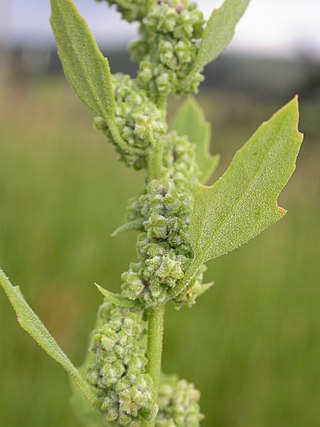
Agriculture on the precontact Great Plains describes the agriculture of the Indigenous peoples of the Great Plains of the United States and southern Canada in the Pre-Columbian era and before extensive contact with European explorers, which in most areas occurred by 1750. The principal crops grown by Indian farmers were maize (corn), beans, and squash, including pumpkins. Sunflowers, goosefoot, tobacco, gourds, and plums, were also grown.

<span class="mw-page-title-main">North Fork Solomon River</span> River in Kansas, United States

The North Fork Solomon River is a river in the central Great Plains of North America. Its entire 287-mile (462 km) length lies within the U.S. state of Kansas. It is a tributary of the Solomon River.

References

  1. Blackmar, Frank Wilson (1912). Kansas: A Cyclopedia of State History, Embracing Events, Institutions, Industries, Counties, Cities, Towns, Prominent Persons, Etc. Standard Publishing Company. pp.  786.
  2. 1 2 3 Entz, Gary R. (2005). "Religion in Kansas". Kansas History: A Journal of the Central Plains. pp. 140-145. Retrieved 2010-09-18.
  3. Buchanan, Rex, Robert Sawin, and Wayne Lebsack (2000). "Water of the Most Excellent Kind: Historic Springs in Kansas". Kansas History: A Journal of the Central Plains. pp. 128-41. Retrieved 2010-09-18.
  4. "Two Cultures: The Kaws". Kaw Mission State Historic Site. Retrieved 2010-09-18.
  5. 1 2 3 4 Grinnell, George Bird (1893). Pawnee Hero Stories and Folk Tales. New York: Charles Scribner's Sons. Retrieved 2010-09-16.
  6. Jensen, Richard E. (1973). "National Register of Historic Places InventoryNomination Form: Pahuk".
  7. Blakeslee, Donald J. Holy Ground, Healing Water: Cultural Landscapes at Waconda Lake, Kansas. pp. 105-112. Retrieved 2010-09-18.
  8. "Healing Waters: The Legend of Waconda Springs". Leisure and Sports Review. Retrieved 2010-09-18.
  9. "The History of Waconda". Archived 2010-08-25 at the Wayback Machine Glen Elder, Kansas. Archived 2011-01-29 at the Wayback Machine Retrieved 2010-09-18.
  10. "Waconda Springs Legend, Great Spirit Springs". Waconda Cultural Association. Retrieved 2024-02-13.

Further reading

39°29′54″N98°22′44″W / 39.49833°N 98.37889°W / 39.49833; -98.37889