Wards Island Bridge

Last updated

Wards Island Bridge
Weeks 533 under Wards Is Bridge jeh.jpg
Open to allow Weeks 533 to pass underneath, 2010
Coordinates 40°47′11″N73°56′15″W / 40.786293°N 73.937409°W / 40.786293; -73.937409 (Wards Island Bridge)
CarriesPedestrians
Crosses Harlem River
Locale Manhattan Island and Wards Island, New York
Maintained by New York City Department of Transportation
Characteristics
Design Vertical lift bridge
Total length1,247 feet (380 m)
Width12 feet (3.7 m)
Longest span312 feet (95 m)
History
OpenedMay 18, 1951
Location
Wards Island Bridge

The Wards Island Bridge, also known as the 103rd Street Footbridge, is a bridge crossing the Harlem River between Manhattan Island and Wards Island in the Manhattan borough of New York City that does not allow vehicular traffic. The vertical lift bridge has a total of twelve spans consisting of steel towers and girders. [1] It carries only pedestrian and bicycle traffic.

Contents

On the Manhattan side of the river, the bridge is located at East 103rd Street, between Exits 14 and 15 of the FDR Drive. The bridge is accessible from the East River Greenway and a pedestrian overpass across the FDR Drive to the East River Houses apartment complex in East Harlem. The bridge connects to the southwestern corner of Wards Island and provides access to the many playing fields and scenic waterfront of Randall's Island and Wards Island Parks.

Wards Island Bridge is open to pedestrians and cyclists 24 hours a day, year-round. [2] [3] Prior to a 2010–2012 renovation, the bridge had only been available for use from April through October during the daytime.

History

The first known bridge to Wards Island was a wooden drawbridge between East 114th Street in Manhattan to the northwest corner of the island. The bridge was built in 1807 to serve a cotton business run by Philip Milledolar and Bartholomew Ward and lasted until 1821, when it was destroyed by a storm. [4]

Pedestrian access to Randalls and Wards Islands was established with the opening of the Triborough Bridge by the Triborough Bridge and Tunnel Authority in 1936. Although plans to construct a separate pedestrian bridge to provide Manhattan residents better access to the new Wards Island Park were developed by Robert Moses in 1937, construction of the bridge did not begin until 1949. [5] [6] Designed by Othmar Hermann Ammann and built by the U.S. Army Corps of Engineers, [7] the footbridge was originally known as the Harlem River Pedestrian Bridge. [8]

View from Manhattan-side ramp, 2007 Ward's Island Bridge, New York City.JPG
View from Manhattan-side ramp, 2007
Wards Island Bridge with the lift lowered to allow pedestrian crossing, 2006 Wards Island Bridge in New York.jpg
Wards Island Bridge with the lift lowered to allow pedestrian crossing, 2006
Wards Island Bridge, Shared Use Sign.jpg

The Wards Island Bridge opened to pedestrians on May 18, 1951 and was completed at a cost of $2.1 million. [9] The bridge was later opened to bicycles in 1967. [10] Although the bridge was originally painted in a red, yellow, and blue color scheme, it was repainted in sapphire blue and emerald green in 1986. [11]

Restricting access to the bridge during the overnight hours and winter months traces back to concerns from residents of the East River Houses in the 1980s and 1990s over patients from the Manhattan State Psychiatric Center who frequently crossed the bridge into Manhattan. Tenants believed that the patients were responsible for increased levels of crime in their neighborhood, although others were unhappy with the limited park access. [12] [13]

In 1999, the New York City Department of Transportation proposed that the bridge be converted to a fixed bridge status. However, this proposal was delayed due to the clearance necessary to float construction equipment up the Harlem River for reconstruction projects associated with the Third Avenue, Willis Avenue, and 145th Street Bridges. [14]

The Wards Island Bridge underwent a $15 million reconstruction between 2010 and 2012, which included replacement of the walkway deck, steel superstructure, and electrical and mechanical control systems. [1] [13] It reopened in June 2012, [3] with the overhaul project costing $16.8 million. [15]

Related Research Articles

<span class="mw-page-title-main">East River</span> Navigable tidal strait in New York City

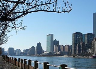
The East River is a saltwater tidal estuary or strait in New York City. The waterway, which is actually not a river despite its name, connects Upper New York Bay on its south end to Long Island Sound on its north end. It separates Long Island, with the boroughs of Brooklyn and Queens, from Manhattan Island, and from the Bronx on the North American mainland.

<span class="mw-page-title-main">Othmar Ammann</span> Swiss-American structural engineer

Othmar Hermann Ammann was a Swiss-American civil engineer whose bridge designs include the George Washington Bridge, Verrazzano-Narrows Bridge, and Bayonne Bridge. He also directed the planning and construction of the Lincoln Tunnel.

<span class="mw-page-title-main">Throgs Neck Bridge</span> Bridge in New York City

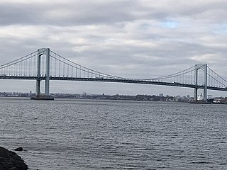
The Throgs Neck Bridge is a suspension bridge in New York City, carrying six lanes of Interstate 295 (I-295) over the East River where it meets the Long Island Sound. The bridge connects the Throggs Neck section of the Bronx with the Bay Terrace section of Queens.

<span class="mw-page-title-main">Robert F. Kennedy Bridge</span> Bridge complex in New York City

The Robert F. Kennedy Bridge is a complex of bridges and elevated expressway viaducts in New York City. The bridges link the boroughs of Manhattan, Queens, and the Bronx. The viaducts cross Randalls and Wards Islands, previously two islands and now joined by landfill.

<span class="mw-page-title-main">Interstate 278</span> Interstate Highway in New Jersey and New York

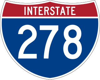
Interstate 278 (I-278) is an auxiliary Interstate Highway in New Jersey and New York in the United States. The road runs 35.62 miles (57.32 km) from US Route 1/9 (US 1/9) in Linden, New Jersey, northeast to the Bruckner Interchange in the New York City borough of the Bronx. The majority of I-278 is in New York City, where it serves as a partial beltway and passes through all five of the city's boroughs. I-278 follows several freeways, including the Union Freeway in Union County, New Jersey; the Staten Island Expressway (SIE) across Staten Island; the Gowanus Expressway in southern Brooklyn; the Brooklyn–Queens Expressway (BQE) across northern Brooklyn and Queens; a small part of the Grand Central Parkway in Queens; and a part of the Bruckner Expressway in the Bronx. I-278 also crosses multiple bridges, including the Goethals, Verrazzano-Narrows, Kosciuszko, and Robert F. Kennedy bridges.

<span class="mw-page-title-main">Hell Gate Bridge</span> Bridge in New York City

The Hell Gate Bridge is a railroad bridge in New York City, New York, United States. The bridge carries two tracks of Amtrak's Northeast Corridor and one freight track between Astoria, Queens, and Port Morris, Bronx, via Randalls and Wards Islands. Its main span is a 1,017-foot (310 m) steel through arch across Hell Gate, a strait of the East River that separates Wards Island from Queens. The bridge also includes several approach viaducts and two spans across smaller waterways. Including approaches, the bridge is 17,000 feet (5,200 m) long. It is one of the few rail connections from Long Island, of which Queens is part, to the rest of the United States.

The Triborough Bridge and Tunnel Authority (TBTA), doing business as MTA Bridges and Tunnels, is an affiliate agency of the Metropolitan Transportation Authority that operates seven toll bridges and two tunnels in New York City. The TBTA is the largest bridge and tunnel toll agency in the United States by traffic volume. It generated more than $2.4 billion in toll revenue from 335 million vehicles in 2023. As of 2023, its operating budget was $596 million; the budget is funded through taxes and fees.

<span class="mw-page-title-main">East Harlem</span> Neighborhood of Manhattan in New York City

East Harlem, also known as Spanish Harlem or El Barrio, is a neighborhood of Upper Manhattan in New York City, north of the Upper East Side and bounded by 96th Street to the south, Fifth Avenue to the west, and the East and Harlem Rivers to the east and north. Despite its name, it is generally not considered to be a part of Harlem proper, but it is one of the neighborhoods included in Greater Harlem.

<span class="mw-page-title-main">Bronx Kill</span> River in New York City

The Bronx Kill is a narrow strait in New York City delineating the southernmost extent of the Bronx. It separates the Bronx from Randalls Island. It connects the Harlem River to the East River.

<span class="mw-page-title-main">Randalls and Wards Islands</span> Conjoined islands in New York City

Randalls Island and Wards Island are conjoined islands, collectively called Randalls and Wards Island, in New York City. Part of the borough of Manhattan, is separated from Manhattan Island by the Harlem River, from Queens by the East River and Hell Gate, and from the Bronx by the Bronx Kill. A channel named Little Hell Gate separated Randalls Island to the north from Wards Island to the south; the channel was filled by the early 1960s. A third, smaller island, Sunken Meadow Island, was located east of Randalls Island and was connected to it in 1955.

<span class="mw-page-title-main">Willis Avenue Bridge</span> Bridge between Manhattan and the Bronx, New York

The Willis Avenue Bridge is a swing bridge that carries road traffic northbound over the Harlem River between the New York City boroughs of Manhattan and the Bronx, United States. It connects First Avenue in Manhattan with Willis Avenue in the Bronx. The New York City Department of Transportation is responsible for maintaining and operating the bridge.

<span class="mw-page-title-main">Manhattan Community Board 11</span> Community District in New York, United States

The Manhattan Community Board 11 is a New York City community board encompassing the Manhattan neighborhoods of East Harlem and Randalls Island. It is delimited by the East River on the east, 96th Street on the south, Fifth Avenue and Mount Morris Park on the west, as well as by the Harlem River on the north. It also includes Ward Island Park and Randall Island Park.

<span class="mw-page-title-main">New York City Department of Transportation</span> New York City government agency

The New York City Department of Transportation (NYCDOT) is the agency of the government of New York City responsible for the management of much of New York City's transportation infrastructure. Ydanis Rodriguez is the Commissioner of the Department of Transportation, and was appointed by Mayor Eric Adams on January 1, 2022. Former Commissioners have included Polly Trottenberg, Janette Sadik-Khan, and Iris Weinshall. The NYCDOT has a training center in eastern Queens.

<span class="mw-page-title-main">Highbridge Park</span> Public park in Manhattan, New York

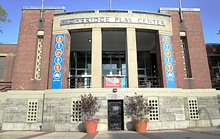
Highbridge Park is a public park on the western bank of the Harlem River in Washington Heights, Manhattan, New York City. It stretches between 155th Street and Dyckman Street in Upper Manhattan. The park is operated by the New York City Department of Parks and Recreation. The City maintains the southern half of the park, while the northern half is maintained by the non-profit New York Restoration Project. Prominent in the park are the Manhattan end of the High Bridge, the High Bridge Water Tower, and the Highbridge Play Center.

<span class="mw-page-title-main">Port Morris, Bronx</span> Neighborhood of the Bronx in New York City

Port Morris is a mixed use, primarily industrial neighborhood geographically located in the southwest Bronx, New York City. The neighborhood is part of Bronx Community Board 1. Its boundaries are the Major Deegan Expressway and Bruckner Expressway to the north, East 149th Street to the east, the East River to the southeast, the Bronx Kill to the south, and the Harlem River to the west. Its ZIP Codes are 10451 and 10454. The neighborhood is served by the NYPD's 40th Precinct.

<span class="mw-page-title-main">Manhattan Waterfront Greenway</span> Esplanade in Manhattan, New York

The Manhattan Waterfront Greenway is a waterfront greenway for walking or cycling, 32 miles (51 km) long, around the island of Manhattan, in New York City. The largest portions are operated by the New York City Department of Parks and Recreation. It is separated from motor traffic, and many sections also separate pedestrians from cyclists. There are three principal parts — the East, Harlem and Hudson River Greenways.

The 125th Street Hudson River bridge was a proposed bridge across the Hudson River between 125th Street in Manhattan, New York City and Cliffside Park or Fort Lee in New Jersey. It was never built.

<span class="mw-page-title-main">East River Greenway</span> Esplanade in Manhattan, New York

The East River Greenway is an approximately 9.44-mile-long (15.19 km) foreshoreway for walking or cycling on the east side of the island of Manhattan on the East River. It is part of the Manhattan Waterfront Greenway. The largest portions are operated by the New York City Department of Parks and Recreation. It is separated from motor traffic, and many sections also separate pedestrians from cyclists. The greenway is parallel to the Franklin D. Roosevelt East River Drive for a majority of its length.

<span class="mw-page-title-main">South Bronx Greenway</span> Hiking trail in New York City

The South Bronx Greenway is a project to improve waterfront access, recreational facilities, and transportation systems, including pedestrian and bicycle paths, in the South Bronx in New York City.

References

  1. 1 2 "New York City's Harlem River Bridges" (PDF). New York City Department of Transportation. January 23, 2004. p. 23. Retrieved August 8, 2009.
  2. "General Information". Randall's Island Park Alliance. Retrieved September 10, 2021.
  3. 1 2 "NYC DOT Commissioner and Council Member Mark-Viverito Reopen Wards Island Bridge" (Press release). New York City Department of Transportation. June 1, 2012. Retrieved January 29, 2021.
  4. "Wards Island Park Historical Sign". New York City Department of Parks & Recreation. Retrieved August 8, 2009.
  5. "Foot Bridge Urged for Wards Island; Moses Wants 790-Foot Span to Link Manhattan to Park Site at 103rd Street". The New York Times. November 8, 1937. Retrieved August 8, 2009.
  6. "Bridge to Be Built to Wards Island; Pedestrian Span Across the Harlem Will Open New Park Facilities to East Siders". The New York Times. June 9, 1949. Retrieved August 8, 2009.
  7. "2009 NYC Bridges & Tunnels Annual Condition Report" (PDF). New York City Department of Transportation. p. 81.
  8. Rastorfer, Darl (2000). Six Bridges: The Legacy of Othmar H. Ammann. Yale University Press. p. 31. ISBN   0-300-08047-6.
  9. "Wards Island Footbridge and Park Open; Moses Calls 'Planning Experts' No Help". The New York Times. May 19, 1951. Retrieved August 8, 2009.
  10. "Bridge to Wards Island Is Opened to Bicyclists". The New York Times. September 15, 1967. Retrieved August 8, 2009.
  11. Anderson, Susan Heller; Prial, Frank J. (September 15, 1986). "For Wards I. Bridge, A Change of Colors". The New York Times. Retrieved August 8, 2009.
  12. Carvajal, Doreen (January 8, 1995). "Wards I. Bridge: History of Problems". The New York Times. Retrieved August 8, 2009.
  13. 1 2 Carlson, Jen (March 30, 2016). "The 12 Best Bridges In NYC". Gothamist. Retrieved August 22, 2021.
  14. "2003 Bridges and Tunnels Annual Condition Report" (PDF). New York City Department of Transportation. 2004. p. 87. Retrieved August 8, 2008.
  15. Margolies, Jane (October 11, 2012). "Randalls Island Paths for Urban Biking". The New York Times. ISSN   0362-4331 . Retrieved May 14, 2019.