Washington County, Oregon

Last updated

Washington County
Washington County Courthouse entrance sign.JPG
Meier Road Barn (Washington County, Oregon scenic images) (washDA0034).jpg
Canola Field in Flower (Washington County, Oregon scenic images) (washDA0035).jpg
From top, left to right: Washington County courthouse, Meier Road Barn, a canola field in rural Washington County
Logo of Washington County, Oregon.png
Map of Oregon highlighting Washington County.svg
Location within the U.S. state of Oregon
Oregon in United States.svg
Oregon's location within the U.S.
Coordinates: 45°34′N123°05′W / 45.56°N 123.09°W / 45.56; -123.09
CountryFlag of the United States.svg United States
StateFlag of Oregon.svg  Oregon
FoundedJuly 5, 1843 (as Twality District)
Named for George Washington
Seat Hillsboro
Largest cityHillsboro
Area
  Total726 sq mi (1,880 km2)
  Land724 sq mi (1,880 km2)
  Water2.2 sq mi (6 km2)  0.3%
Population
 (2020)
  Total600,372
  Estimate 
(2023)
598,865 Decrease2.svg
  Density830/sq mi (320/km2)
Time zone UTC−8 (Pacific)
  Summer (DST) UTC−7 (PDT)
Congressional districts 1st, 6th
Website www.washingtoncountyor.gov

Washington County is one of 36 counties in the U.S. state of Oregon and part of the Portland metropolitan area. The 2020 census recorded the population as 600,372, [1] making it the second most populous county in the state and most populous "Washington County" in the United States. Hillsboro is the county seat and largest city, [2] [3] while other major cities include Beaverton, Tigard, Cornelius, Banks, Gaston, Sherwood, North Plains, and Forest Grove, the county's oldest city. [4] Originally named Twality when created in 1843, the Oregon Territorial Legislature renamed it for the nation's first president in 1849 and included the entire northwest corner of Oregon before new counties were created in 1854. The Tualatin River and its drainage basin lie almost entirely within the county, which shares its boundaries with the Tualatin Valley. It is bordered on the west and north by the Northern Oregon Coast Range, on the south by the Chehalem Mountains, and on the north and east by the Tualatin Mountains, or West Hills.

Contents

Major roads include sections of Interstate 5 and 205, the Sunset Highway, Oregon Route 217, 47, 10, 6 and 8. Public transportation is primarily operated by TriMet and includes buses, the Westside Express Service commuter rail, and MAX Light Rail. Other transportation includes air travel at Hillsboro Airport, private airfields and heliports, and heavy rail cargo on rail lines.

History

County jail in Hillsboro Washington County Jail - Hillsboro, Oregon.JPG
County jail in Hillsboro

The Provisional Legislature of Oregon created the county as Twality District on July 5, 1843. Twality was one of the original four districts of the Provisional Government of Oregon in Oregon Country along with Clackamas, Champooick (later Marion), and Yamhill counties. Columbia, later known as Hillsboro, was selected as the county seat in 1850. Washington County lost significant portions of its original area when Columbia and Multnomah counties were created in 1854. The county area was increased by 160 acres (65 ha) in 2014 when a section of Multnomah County was attached to Washington. [5] The area was returned to Washington County to allow for property development. [6]

The construction of Canyon Road to Beaverton helped Portland to consolidate its position as the primary port of Oregon, and defeat the rival efforts of settlements such as Oregon City and Milwaukie.

In November 2004, the County and the City of Beaverton agreed to a plan where the city would annex both unincorporated residential neighborhoods as well as high-value areas of land. This would result with Cedar Hills, Garden Home, Raleigh Hills, West Slope being incorporated by 2010, and the communities of Aloha, Bethany, and Cedar Mill at some point after that.

Those plans have since been put on hold after Beaverton attempted to annex Nike, Inc.'s World Headquarters, which would have increased Nike's taxes substantially. Nike successfully lobbied the legislature for a law that would prohibit their annexation for 99 years. Since that decision, annexation plans have been halted, and Washington County started urban planning to provide city-level services to the unincorporated urban areas in the county. [7]

Geography

According to the United States Census Bureau, the county has a total area of 726 square miles (1,880 km2), of which 724 square miles (1,880 km2) is land and 2.2 square miles (5.7 km2) (0.3%) is water. [8] It is located approximately 20 miles (32 km) to the west of Portland. The Portland Metro Urban Growth Boundary (UGB) bisects the county. The county's highest point is South Saddle Mountain at 3,464 feet (1,056 m) above sea level in the Northern Oregon Coast Range. [9]

Most of the county is in the Tualatin Valley, formed by the Tualatin Mountains to the east and north, the Chehalem Mountains to the south, and the Northern Oregon Coast Range to the west and north. The Tualatin River, located almost entirely within the county, flows through the Tualatin Plains. The northern and western portions of the county are forested, while the remainder of the county includes urban areas, agricultural lands, and floodplains. [10]

Waterways

The Tualatin River is the main river in Washington County. Henry Hagg Lake, southwest of Forest Grove, is the largest lake. The Willamette River lies to the east, the Columbia River to the northeast, and the Pacific Ocean to the west of the county.

Adjacent counties

Map of Washington County Washington County.svg
Map of Washington County

Major highways

National protected areas

Demographics

Historical population
CensusPop.Note
1850 2,652
1860 2,8015.6%
1870 4,26152.1%
1880 7,08266.2%
1890 11,97269.0%
1900 14,46720.8%
1910 21,52248.8%
1920 26,37622.6%
1930 30,27514.8%
1940 39,19429.5%
1950 61,26956.3%
1960 92,23750.5%
1970 157,92071.2%
1980 245,80855.7%
1990 311,55426.7%
2000 445,34242.9%
2010 529,71018.9%
2020 600,37213.3%
2023 (est.)598,865 [11] −0.3%
U.S. Decennial Census [12]
1790–1960 [13] 1900–1990 [14]
1990–2000 [15] 2010–2020 [1]

2010 census

As of the 2010 census, there were 529,710 people, 200,934 households, and 134,323 families residing in the county. [16] The population density was 731.4 inhabitants per square mile (282.4/km2). There were 212,450 housing units at an average density of 293.3 per square mile (113.2/km2). [17] The racial makeup of the county was 76.6% white, 8.6% Asian, 1.8% black or African American, 0.7% American Indian, 0.5% Pacific islander, 7.5% from other races, and 4.3% from two or more races. Those of Hispanic or Latino origin made up 15.7% of the population. [16] In terms of ancestry, 20.8% were German, 12.4% were English, 12.1% were Irish, and 3.2% were American. [18]

Of the 200,934 households, 36.0% had children under the age of 18 living with them, 52.2% were married couples living together, 10.1% had a female householder with no husband present, 33.2% were non-families, and 25.1% of all households were made up of individuals. The average household size was 2.60 and the average family size was 3.14. The median age was 35.3 years. [16]

The median income for a household in the county was $62,574 and the median income for a family was $76,778. Males had a median income of $54,417 versus $40,254 for females. The per capita income for the county was $30,522. About 6.7% of families and 9.5% of the population were below the poverty line, including 12.5% of those under age 18 and 6.7% of those age 65 or over. [19]

2000 census

As of the 2000 census, there were 445,342 people, 169,162 households, and 114,015 families in the county. The population density was 615 people per square mile (237 people/km2). There were 178,913 housing units at an average density of 247 units per square mile (95/km2). The racial makeup of the county was 82.19% White, 1.15% Black or African American, 0.65% Native American, 6.68% Asian, 0.30% Pacific Islander, 5.86% from other races, and 3.17% from two or more races. 11.17% of the population were Hispanic or Latino of any race. 17.2% were of German, 9.9% English, 8.2% Irish, and 6.7% American ancestry. 81.7% spoke only English at home, while 9.6% spoke Spanish and 1.2% Vietnamese.

There were 169,162 households, out of which 35.60% had children under the age of 18 living with them, 54.50% were married couples living together, 9.00% had a female householder with no husband present, and 32.60% were non-families. 24.70% of all households were made up of individuals, and 6.70% had someone living alone who was 65 years of age or older. The average household size was 2.61 and the average family size was 3.14.

The county population contained 26.90% under the age of 18, 9.30% from 18 to 24, 34.10% from 25 to 44, 20.90% from 45 to 64, and 8.80% who were 65 years of age or older. The median age was 33 years. For every 100 females, there were 99.10 males. For every 100 females age 18 and over, there were 97.00 males.

The median income for a household in the county was $52,122, and the median income for a family was $61,499. Males had a median income of $43,304 versus $31,074 for females. The per capita income for the county was $24,969. About 4.90% of families and 7.40% of the population were below the poverty line, including 8.30% of those under age 18 and 5.30% of those age 65 or over.

Government

The county is governed by an elected board of five commissioners. The county is divided into four commissioner districts. One commissioner sits for each district, and the fifth commissioner is at-large and is the chair of the board. [20]

Politics

Like all of the Yankee-influenced Willamette Valley and Oregon Coast, Washington County was in its pre-Depression history strongly Republican. After Oregon achieved statehood in 1859, Washington County voted for the Republican presidential nominee in every presidential election from 1860 to 1928, except in the 1912 presidential election when the county supported Progressive Party candidate and former Republican president Theodore Roosevelt. [21] In 1932, Franklin D. Roosevelt became the first Democrat to carry the Washington County vote, and he repeated this in 1936 and 1940. Between 1944 and 1988, Washington County was never won by a Democrat except in Lyndon B. Johnson's 1964 landslide. As late as 1976, Washington County was the second-most Republican county in the state of Oregon behind remote Malheur, [22] with Gerald Ford's 17,529 vote victory in the county being decisive in carrying the state of Oregon for him during that year's presidential election.

Since the 1990s, the increasing drift of the Republican Party nationally towards the South and evangelicalism, along with urbanization, has resulted in a strong shift of Washington County towards the Democratic Party. No Republican presidential candidate has carried Washington County since George H. W. Bush did so in 1988, and in three of the past four presidential elections, Barack Obama, Hillary Clinton, and Joe Biden have carried the county by over twenty percentage points. The last Republican to win a statewide election in Washington County was Gordon H. Smith in the 2002 Senate contest. In the 2008 Senatorial election, Democrat Jeff Merkley won 48.8 percent of the county's vote (111,367) while Republican incumbent Smith won 46.5 percent (106,114), [23] but no subsequent Republican Senate candidate has won 40 percent of the county's vote. In the 2020 presidential election, Biden hit 65.5% of the county's vote, the highest ever for a Democratic presidential nominee.

United States presidential election results for Washington County, Oregon [24]
Year Republican Democratic Third party
No.%No.%No.%
2020 99,07330.93%209,94065.54%11,3133.53%
2016 83,19730.90%153,25156.92%32,78412.18%
2012 93,97439.65%135,29157.08%7,7583.27%
2008 89,18537.69%141,54459.82%5,9032.49%
2004 107,22346.36%121,14052.37%2,9451.27%
2000 86,09146.29%90,66248.75%9,2214.96%
1996 65,22140.83%76,61947.96%17,91511.21%
1992 57,14634.18%67,52840.39%42,52125.43%
1988 67,01851.87%59,83746.31%2,3561.82%
1984 75,87762.76%44,60236.89%4170.34%
1980 57,16551.34%37,91534.05%16,27514.62%
1976 52,37657.80%34,84738.46%3,3883.74%
1972 43,95858.43%27,89037.07%3,3904.51%
1968 34,10556.99%22,94338.34%2,7944.67%
1964 20,81341.48%29,08157.95%2870.57%
1960 25,41558.85%17,73641.07%350.08%
1956 22,00161.07%14,02738.93%00.00%
1952 20,25064.11%11,19135.43%1430.45%
1948 11,45553.06%9,42443.65%7103.29%
1944 9,36250.13%9,11048.78%2051.10%
1940 8,36748.92%8,62650.44%1100.64%
1936 4,14830.47%8,64163.48%8236.05%
1932 4,20136.30%6,82458.96%5484.74%
1928 6,16262.37%3,54435.87%1731.75%
1924 4,20345.98%2,10323.01%2,83531.01%
1920 4,94764.74%2,26229.60%4325.65%
1916 4,88856.16%3,36338.64%4525.19%
1912 1,26127.07%1,42930.67%1,96942.26%
1908 2,31961.96%1,15330.80%2717.24%
1904 2,29673.19%49215.68%34911.13%
1900 1,65556.14%1,11437.79%1796.07%
1896 2,08256.15%1,56642.23%601.62%
1892 1,58753.27%2939.84%1,09936.89%
1888 1,24957.93%83838.87%693.20%
1884 94651.22%76641.47%1357.31%
1880 88058.86%57838.66%372.47%

Statewide elections

Previous gubernatorial election results
Year Democratic Republican Third parties
2022 55.08%140,94635.59% 91,0689.33% 23,868
2018 55.49%137,88639.15% 97,2865.36% 13,307
2014 51.45%98,20342.69% 81,4845.57% 10,600
2010 49.62%92,81148.08% 89,9262.30% 4,296
2006 59.09%51,19538.98% 33,7771.93% 1,674
2002 64.92%60,09534.40% 31,8440.68% 633
1998 66.83%50,32533.14% 24,9560.03% 23
1994 57.68%45,26142.32% 33,2100.00% 1

Economy

The Washington County Courthouse in Hillsboro Washington County Courthouse east facade 2015 - Hillsboro Oregon.jpg
The Washington County Courthouse in Hillsboro

Washington County is centered on a fertile plain that attracted farmers before the first wagon trains. In 1997, orchards covered 8,403 acres (34.01 km2) of the county's lands and 1,163 acres (4.71 km2) were devoted to vineyards.[ citation needed ] Agriculture is still a major industry in Washington County, as are lumber, manufacturing, and food processing.

The development of a large electronics industry during the 1980s and 1990s is the dominating factor of the county economy, and contributing to the creation of Oregon's Silicon Forest. California-based Intel, Oregon's largest private-sector employer, [25] has its largest concentration of employees in the county, mainly in Hillsboro. [26] Other technology companies include Electro Scientific Industries, FEI Company, Qorvo, Tektronix, SolarWorld, Planar Systems, and EPSON. [27]

Nike, one of two Fortune 500 corporations based in Oregon, has its headquarters in Washington County. Until it was acquired by IBM, Sequent Computer Systems was headquartered near Nike. Other companies with headquarters in Washington County include optical instruments manufacturer Leupold & Stevens, Columbia Sportswear, and Reser's Fine Foods.

Communities

Part of The Round in Beaverton, with the Beaverton Central MAX light rail station in center. Beaverton Central MAX station - Beaverton, Oregon.JPG
Part of The Round in Beaverton, with the Beaverton Central MAX light rail station in center.
Downtown Forest Grove in 1920 Forest Grove Oregon Pacific Avenue 1920.jpg
Downtown Forest Grove in 1920

Cities

City1990 population2000 population2010 population2020 populationIncorporatedNotes
Banks 5631,2861,7771,8371921
Beaverton 53,31076,12989,80397,4941893
Cornelius 6,1489,65211,86912,6941893
Durham 7481,3821,3511,9441966
Forest Grove 13,55917,70821,08326,2251872
Gaston 5636006376761914
Hillsboro 37,52070,18791,611106,4471876County seat
King City 2,0601,9493,1115,1841966
Lake Oswego 30,57635,27836,61940,7311910Small portion, most in Clackamas County [28]
North Plains 9721,6051,9473,4411963
Portland 437,319529,121583,776652,5031851Small portion, most in Multnomah County [29]
Rivergrove 2943242895451971Small portion, most in Clackamas County
Sherwood 3,09311,79118,19420,4501893
Tigard 29,34441,22348,03554,5391961
Tualatin 15,01322,79126,05427,9421913
Wilsonville 7,10613,99119,50926,6641969Small portion, most in Clackamas County [30]

Census-designated places

Unincorporated communities

Helvetia

Helvetia is a small unincorporated community in Washington County, Oregon. It is located in the Tualatin Valley along U.S. Route 26, 15 minutes west of Portland. It was named by Swiss immigrants to Oregon in the 19th century.

The reality television series Little People, Big World is set on Roloff Farms in Helvetia, making the location a popular tourist attraction. The Helvetia area is only a few miles from both the Intel and Nike headquarters campuses. It consists of heritage farms and million dollar estate properties. The area is part of Tualatin Valley Fire and Rescue's service area. [31]

The Holcomb Creek Trestle, the longest wooden railroad bridge currently in use in the United States, is located in the Helvetia area.

See also

Related Research Articles

<span class="mw-page-title-main">Beaverton, Oregon</span> City in Oregon, United States

Beaverton is a city in Washington County, in the U.S. state of Oregon with a small portion bordering Portland in the Tualatin Valley. The city is among the main cities that make up the Portland metropolitan area. Its population was 97,494 at the 2020 census, making it the second most populous city in the county and the seventh most populous city in Oregon. Beaverton is an economic center for Washington County along with neighboring Hillsboro.

<span class="mw-page-title-main">Tigard, Oregon</span> City in Oregon, United States

Tigard is a city in Washington County, Oregon, United States. The population was 54,539 at the 2020 census, making it the 12th most populous city in Oregon. Incorporated in 1961, the city is located south of Beaverton and north of Tualatin, and is part of the Portland metropolitan area. Interstate 5 and Oregon Route 217 are the main freeways in the city, with Oregon Route 99W and Oregon Route 210 serving as other major highways. Public transit service is provided by TriMet, via several bus routes and the WES Commuter Rail line.

<span class="mw-page-title-main">Yamhill County, Oregon</span> County in Oregon, United States

Yamhill County is one of the 36 counties in the U.S. state of Oregon. As of the 2020 census, the population was 107,722. The county seat is McMinnville. Yamhill County was named after the Yamhelas, members of the Kalapuya Tribe.

<span class="mw-page-title-main">Clackamas County, Oregon</span> County in Oregon, United States

Clackamas County is one of the 36 counties in the U.S. state of Oregon. As of the 2020 census, the population was 421,401, making it Oregon's third-most populous county. Its county seat is Oregon City. The county was named after the native people living in the area at the time of the coming of Europeans, the Clackamas people, who are part of the Chinookan peoples.

<span class="mw-page-title-main">Aloha, Oregon</span> Unincorporated community in the state of Oregon, United States

Aloha is a census-designated place and unincorporated community in Washington County, Oregon, United States. By road it is 10.9 miles (17.5 km) west of downtown Portland. As of the 2020 Census, the population was 53,828. Fire protection and EMS services are provided through Tualatin Valley Fire and Rescue and Metro West Ambulance.

<span class="mw-page-title-main">Cedar Hills, Oregon</span> Unincorporated community in the state of Oregon, United States

Cedar Hills is a census-designated place and neighborhood in Washington County, Oregon, United States south of U.S. Route 26 and west of Oregon Route 217 and within the Portland metropolitan area. Construction began in 1946.

<span class="mw-page-title-main">Cedar Mill, Oregon</span> Unincorporated community in the state of Oregon, United States

Cedar Mill is a suburb in the Portland, Oregon metropolitan area of the United States; it is a census-designated place and an unincorporated community in Washington County, north of U.S. Route 26 and west of the Willamette Stone. It received its name from a sawmill on Cedar Mill Creek, which cut Western Redcedars that were once the dominant tree in the area. The mill's pond was near the intersection of 119th and Cornell Road, and could still be seen into the 1960s, although the mill itself had ceased operating in 1891. The name was established in 1874 with the opening of a U.S. post office named Cedar Mill. As of the 2020 census, the community population was 17,259.

<span class="mw-page-title-main">Cornelius, Oregon</span> City in Oregon, United States

Cornelius is a city in Washington County, Oregon, United States. Located in the Portland metropolitan area, the city's population was 11,869 at the 2010 census. The city lies along Tualatin Valley Highway between Forest Grove to the west and Hillsboro to the east. Cornelius was incorporated in 1893 and is named for founder Thomas R. Cornelius.

<span class="mw-page-title-main">Forest Grove, Oregon</span> City in Oregon, United States

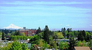
Forest Grove is a city in Washington County, Oregon, United States, 25 miles (40 km) west of Portland. Originally a small farm town, it is now primarily a commuter town in the Portland metro area. Settled in the 1840s, the town was platted in 1850, then incorporated in 1872, making it the first city in Washington County. The population was 21,083 at the 2010 census, an increase of 19.1% over the 2000 figure (17,708).

<span class="mw-page-title-main">Garden Home–Whitford, Oregon</span> CDP in Oregon, United States

Garden Home-Whitford is a census-designated place (CDP) consisting of the neighborhoods of Garden Home and the smaller Whitford area in Washington County, Oregon, United States. They are located in the southwest hills of Portland, near Beaverton. As of the 2020 census, the CDP population was 7,081.

<span class="mw-page-title-main">Hillsboro, Oregon</span> City in Oregon, United States

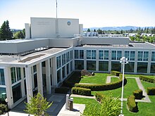
Hillsboro is a city in the U.S. state of Oregon and is the county seat of Washington County. Situated in the Tualatin Valley on the west side of the Portland metropolitan area, the city hosts many high-technology companies, such as Intel, locally known as the Silicon Forest. The population was 106,447 at the 2020 census, making Hillsboro the 5th most populous city in Oregon.

<span class="mw-page-title-main">North Plains, Oregon</span> City in Oregon, United States

North Plains is a city in Washington County, Oregon, United States, off U.S. 26 on the northwest outskirts of the Portland metropolitan area. The population was 3,441 at the 2020 census.

<span class="mw-page-title-main">Raleigh Hills, Oregon</span> Unincorporated community in the state of Oregon, United States

Raleigh Hills is a census-designated place and neighborhood in Washington County, Oregon within the metropolitan area of Portland, Oregon, United States. It is located in the southwest hills in Washington County, with Beaverton to the west, West Slope to the north, and Progress and Garden Home to the south. As of the 2000 census, the census-designated place had a total population of 5,865.

<span class="mw-page-title-main">Rockcreek, Oregon</span> Unincorporated community in the state of Oregon, United States

Rockcreek is a census-designated place in Washington County, Oregon, United States, north of U.S. Route 26. It is named for the Rock Creek neighborhood in the area. As of the 2010 census, the CDP population was 9,316. Named for Rock Creek, a tributary of the Tualatin River, that flows north to south through the neighborhood.

<span class="mw-page-title-main">West Haven-Sylvan, Oregon</span> CDP in Oregon, United States

West Haven-Sylvan is a census-designated place (CDP) in Washington and Multnomah counties, Oregon, United States, north of U.S. Route 26. As of the 2020 census, the CDP population was 9,299.

<span class="mw-page-title-main">West Slope, Oregon</span> Unincorporated community in the state of Oregon, United States

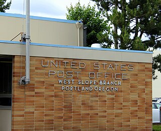
West Slope is an unincorporated suburb of Portland, Oregon, United States and a census-designated place. It is in Washington County, to the west of Portland's West Hills neighborhood, to the northwest of Raleigh Hills and south of U.S. Route 26. Fire protection and EMS services are provided through Tualatin Valley Fire and Rescue.

<span class="mw-page-title-main">Tualatin, Oregon</span> City in Oregon, United States

Tualatin is a city located primarily in Washington County in the U.S. state of Oregon. A small portion of the city is also located in neighboring Clackamas County. It is a southwestern suburb in the Portland Metropolitan Area that is located south of Tigard. The population was 27,942 at the 2020 census.

<span class="mw-page-title-main">Tualatin Valley</span> Farming and suburban region southwest of Portland, Oregon

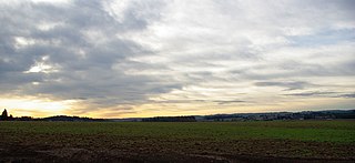
The Tualatin Valley is a farming and suburban region southwest of Portland, Oregon. The valley is formed by the meandering Tualatin River, a tributary of the Willamette River at the northwest corner of the Willamette Valley, east of the Northern Oregon Coast Range. Most of the valley is located within Washington County, separated from Portland by the Tualatin Mountains. Communities in the Tualatin Valley include Banks, Forest Grove, Cornelius, Hillsboro, Aloha, Beaverton, Sherwood, Tigard, and Tualatin.

<span class="mw-page-title-main">Portland metropolitan area, Oregon</span> Metropolitan statistical area in the US

The Portland metropolitan area is a metro area with its core in the U.S. states of Oregon and Washington. It has 5 principal cities the largest being Portland, Oregon. The U.S. Office of Management and Budget (OMB) identifies it as the Portland–Vancouver–Hillsboro, OR–WA Metropolitan Statistical Area, a metropolitan statistical area used by the United States Census Bureau (USCB) and other entities. The OMB defines the area as comprising Clackamas, Columbia, Multnomah, Washington, and Yamhill Counties in Oregon, and Clark and Skamania Counties in Washington. The area had a population of 2,512,859 at the 2020 census, an increase of over 12% since 2010.

<span class="mw-page-title-main">Tualatin Plains</span> Region in Oregon, United States

The Tualatin Plains are a prairie area in central Washington County, Oregon, United States. Located around the Hillsboro and Forest Grove areas, the plains were first inhabited by the Atfalati band of the Kalapuya group of Native Americans. Euro-American settlement began in the 1840s.

References

  1. 1 2 "State & County QuickFacts". United States Census Bureau. Retrieved April 21, 2023.
  2. Proehl, Risa S. (March 2009). "2008 Oregon Population Report" (PDF). Population Research Center. Portland State University. p. 7. Archived from the original (PDF) on March 3, 2016. Retrieved May 5, 2009.
  3. "Find a County". National Association of Counties. Retrieved June 7, 2011.
  4. "Incorporation dates". The Hillsboro Argus. October 19, 1976. pp. Communities, p. 21.
  5. "Oregon Secretary of State: Washington County History". sos.oregon.gov. Retrieved April 1, 2018.
  6. "County welcomes Area 93 in new year". Hillsboro Tribune . January 10, 2014. Archived from the original on January 16, 2014. Retrieved January 6, 2020.
  7. "Appellate court rejects Beaverton annexation". The Oregonian. June 16, 2006.
  8. "2010 Census Gazetteer Files". United States Census Bureau. August 22, 2012. Retrieved February 28, 2015.
  9. "South Saddle Mountain - Peakbagger.com". www.peakbagger.com. Archived from the original on April 1, 2018. Retrieved April 1, 2018.
  10. ""Washington County OR" (Google Maps - accessed October 19, 2019)".
  11. "Annual Estimates of the Resident Population for Counties: April 1, 2020 to July 1, 2023". United States Census Bureau. Retrieved March 24, 2024.
  12. "U.S. Decennial Census". United States Census Bureau. Retrieved February 28, 2015.
  13. "Historical Census Browser". University of Virginia Library. Retrieved February 28, 2015.
  14. Forstall, Richard L., ed. (March 27, 1995). "Population of Counties by Decennial Census: 1900 to 1990". United States Census Bureau. Retrieved February 28, 2015.
  15. "Census 2000 PHC-T-4. Ranking Tables for Counties: 1990 and 2000" (PDF). United States Census Bureau. April 2, 2001. Archived from the original (PDF) on February 26, 2015. Retrieved February 28, 2015.
  16. 1 2 3 "Profile of General Population and Housing Characteristics: 2010 Demographic Profile Data". United States Census Bureau. Archived from the original on February 13, 2020. Retrieved February 23, 2016.
  17. "Population, Housing Units, Area, and Density: 2010 - County". United States Census Bureau. Archived from the original on February 13, 2020. Retrieved February 23, 2016.
  18. "Selected Social Characteristics in the US – 2006-2010 American Community Survey 5-Year Estimates". United States Census Bureau. Archived from the original on February 13, 2020. Retrieved February 23, 2016.
  19. "Selected Economic Characteristics – 2006-2010 American Community Survey 5-Year Estimates". United States Census Bureau. Archived from the original on February 13, 2020. Retrieved February 23, 2016.
  20. "Washington County, Oregon". www.co.washington.or.us. Retrieved April 1, 2018.
  21. Menendez, Albert J. (2005). The Geography of Presidential Elections in the United States, 1868-2004. McFarland. pp. 284–286. ISBN   0786422173.
  22. David Leip. "1976 Presidential General Election Data Graphs – Oregon by County". uselectionatlas.org. Retrieved July 8, 2013.
  23. David Leip. "2008 Senatorial General Election Results – Oregon". uselectionatlas.org. Retrieved July 8, 2013.
  24. Leip, David. "Atlas of US Presidential Elections". uselectionatlas.org. Retrieved April 1, 2018.
  25. "Intel in Oregon". Intel. Retrieved February 16, 2017.
  26. "Oregon's largest private employer, Intel, announces plans to expand in Europe". opb. Retrieved November 11, 2022.
  27. "Key Industries | City of Hillsboro, OR". www.hillsboro-oregon.gov. Retrieved November 11, 2022.
  28. City of Lake Oswego Archived September 23, 2006, at the Wayback Machine
  29. "PortlandOnline".
  30. City of Wilsonville Archived June 9, 2011, at the Wayback Machine
  31. "TVFR's Service Area Map". TVFR. Retrieved July 17, 2019.

45°34′N123°05′W / 45.56°N 123.09°W / 45.56; -123.09