Wawasan Nusantara

Last updated
Modern Wawasan Nusantara, the Indonesian archipelagic baselines pursuant to article 47, paragraph 9, of the United Nations Convention on the Law of the Sea (UNCLOS) Indonesian archipelagic baselines.jpg
Modern Wawasan Nusantara, the Indonesian archipelagic baselines pursuant to article 47, paragraph 9, of the United Nations Convention on the Law of the Sea (UNCLOS)

Wawasan Nusantara, or Indonesian Archipelagic Vision, is the national vision of Indonesia towards their people, nation, and territory of the unitary state of the Republic of Indonesia (including its land and sea as well as the air and space above it) as a unity of political, economic, social, cultural, defensive and security-driven entities. [1] :29 This national insight subsequently serves as the perspective or vision of the nation towards its national goals and ideals. [2]

Contents

Wawasan nusantara is meant to be adopted as the Indonesian geopolitical stance, [2] or the geographic effect of the archipelago on regional politics and international relations, regarded from an Indonesian perspective that advocates for the national interest of the entire republic. The wawasan nusantara geopolitical stance is often used by the Indonesian government to argue for national maritime integrity in some issues of territorial disputes with neighbouring countries.

Since the mid-1980s, the concept of wawasan nusantara has been included in the Indonesian education curriculum and taught within geography education in high school. The subject of wawasan nusantara is also taught in kewiraan (civics and citizenship) education in universities to educate about citizenship, nationalism and Indonesian geopolitical standpoints. [3] In 2019, the Indonesian Geography Community (Komunitas Geografi) submitted a proposal to teach geography as early as elementary school, a wawasan nusantara concept with emphasis on disaster mitigation, management and response processes as part of national resilience; it would be in accordance with Indonesian geography and geology as an archipelagic nation located right on top of the Ring of Fire, which is prone to natural disasters. [4]

Etymology and definition

Students get an explanation about the concept of Nusantara, in front of the gold-plated archipelago map, symbolizing the homeland of the Unitary Republic of Indonesia in the Monas Independence Hall, Jakarta. Indonesian Archipelago and Students.JPG
Students get an explanation about the concept of Nusantara, in front of the gold-plated archipelago map, symbolizing the homeland of the Unitary Republic of Indonesia in the Monas Independence Hall, Jakarta.

In Indonesian, wawasan means "vision", "insight" or "concept", while Nusantara generally refer to the Indonesian archipelago, [5] [6]

Wawasan nusantara is the fundamental standpoint of Indonesian geopolitics. Literally, wawasan nusantara means the "archipelagic concept"; contextually this term is more accurately translated as "Indonesian archipelagic vision". Wawasan nusantara is a way for Indonesia to look at itself (geographically) as a unity of ideology, politics, economy, socio-cultural, security and defense aspects. [7]

Wawasan Nusantara is the archipelagic insight of Indonesian geopolitics. It is the perspective of the Indonesian people regarding themselves, their homeland, and the strategic values of their surroundings. It prioritize national unity and integrity, while still respecting every aspect of regional diversity to achieve national goals. [8]

The concept attempts to overcome Indonesia inherent geographic challenges—a state that comprises thousands of islands as well as thousands of socio-cultural backgrounds of its people. Vis-à-vis the state that eager and fighting for a national unification, the waters between the islands must be considered as the connectors rather than separators. [7]

Furthermore, wawasan nusantara is related to the ideological and constitutional basis, namely as a perspective and attitude of the Indonesian people regarding themselves and their geographical location, according to the national ideology Pancasila and the Constitution of 1945. [9] In its implementation, wawasan nusantara prioritises regional unity while honouring its diversity to achieve social harmony, common prosperity, progress, and other national goals. [9]

Two Indonesian statesman are credited for the development this Indonesian geopolitics concept; they are Djuanda Kartawidjaja—credited for the 1957 Djuanda Declaration, and Mochtar Kusumaatmadja—former Indonesian foreign minister (1978–1988) that advocated for archipelagic insight to be accepted internationally. [10]

Background

History

The image of a 9th-century ship on Borobudur bas relief, which argues for Indonesia's past as a regional maritime power. Borobudur ship.JPG
The image of a 9th-century ship on Borobudur bas relief, which argues for Indonesia's past as a regional maritime power.

In Indonesian history, the native ancient kingdoms that rose to become a regional hegemon are usually a thalassocracy; such as Srivijaya (7th to 12th century) and Majapahit (14th to 15th century). [11] This was much owed to the strategic location of Indonesian archipelago as the nexus of ancient global trade connecting two centers of Asian civilisations—ancient India and imperial China, involved actively in global spice trade, which was also the important part of ancient maritime silk road.

During the Dutch East Indies period, the Ordonantie (Dutch Law) 1939, mentioned about the determination of the territorial sea which was along the 3 nautical miles width by drawing along a base line based on the tidal or island contour. This provision creates international waters in many parts of the sea between Indonesian islands (e.g. in the center of Java Sea and Banda Sea) which was outside the national jurisdiction.

Indonesians shared a historical experiences of regional disunity, which must be avoided for the survival of the nation. This is because the national independence has been achieved through the spirit of unity among Indonesian people themselves. Thus, this spirit must be nurtured and maintained for national unity to preserve and protect territorial integrity of Indonesia. [12]

After the independence, Indonesia find itself as the custodian of world's main shipping lanes connecting Pacific Ocean with Indian Ocean, connecting East Asia with Middle East and Australia. Those main lanes are Malacca Strait, Karimata Strait, Sunda Strait, Makassar Strait, Lombok Strait and Ombai Strait. Sitting on the nexus of global maritime trade route has made Indonesian waters prone to be involved in global power struggle between global maritime powers. Thus, ensuring security of its territorial waters is a national priority.

On 13 December 1957, Indonesian Government announced Djuanda Declaration regarding the territorial waters of the Republic of Indonesia. In this declaration, the sea boundaries is no longer based on tidal lines, but on a straight base line measured from the outline connecting the outermost points of the islands which are included within the territory of the Republic of Indonesia. [13] This erased international waters between Indonesian islands, thus increase the territorial waters. The determination of territorial waters are increased from 3 nautical miles to 12 nautical miles. The Exclusive Economic Zone (EEZ) as an International Law regime, in which the 200-mile archipelagic boundaries are measured from the baseline of Indonesian territorial waters. With the Djuanda Declaration, thus legally and formally Indonesia became a whole undivided unity of lands and waters.

Socio-cultural

A map in National Museum displaying ethnic distribution and diversity in Indonesia. Ethnic Map in the National Museum of Indonesia.jpg
A map in National Museum displaying ethnic distribution and diversity in Indonesia.

Indonesia consists of hundreds of ethnic groups, each of which has different customs, languages, religions, and belief systems. Naturally, that national life related to inter-group interactions, contains the potential for conflicts over such differences in cultural diversity. [12]

The territorial aspects of the archipelago

The geographic factor, its effects and influences, are the phenomenon that needs to be carefully examined, because Indonesia is rich in various natural resources as well as the diversity of its ethnic groups. [12]

Pancasila philosophy

The golden Garuda Pancasila in Monas bearing the symbols of Pancasila, the national ideology of Indonesia. Garuda Pancasila.jpg
The golden Garuda Pancasila in Monas bearing the symbols of Pancasila, the national ideology of Indonesia.

Pancasila values underlie the development of the wawasan nusantara concept. These values are: [12]

  1. Implementation of human rights, such as freedom of religion; providing opportunities to practice worship in accordance with their respective religions.
  2. Prioritising the interests of the whole larger society rather than those of individuals or groups.
  3. Decision making based on deliberation to reach consensus.

Purpose

Law of Sea Convention as described in Djuanda declaration Law of the Sea Convention.svg
Law of Sea Convention as described in Djuanda declaration
  1. Wawasan nusantara as a concept of national resilience; namely as a concept in national development, security, defense and territorial aspects. [14]
  2. Wawasan nusantara as a development perspective; it has the scope of political unity, economic unity, socio-economic unity, socio-political unity, also defense and security unity.
  3. Wawasan nusantara as a vision of national defense and security; as a geopolitical view of Indonesia within the scope of its homeland as a unity that encompasses all of its territory and which protected with all of the might the nation. [14]
  4. Wawasan nusantara as territorial vision; which clearly defines Indonesia's national boundaries, to avoid disputes with neighboring countries. Boundaries and challenges of Indonesia are: [14]
  1. The way to withdraw sea boundaries is no longer based on tidal lines (low water line), but on a straight base line measured from the outline connecting the outermost points of the islands which are included within the territory of the Republic of Indonesia.
  2. Determination of territorial waters are increased from 3 nautical miles to 12 nautical miles.
  3. Exclusive Economic Zone (EEZ) as an International Law regime, in which the 200-mile archipelagic boundaries are measured from the baseline of Indonesian territorial waters. With the Djuanda Declaration, thus legally and formally Indonesia became a whole and not divided again.

Objective

The purpose of wawasan nusantara consists of two objectives, they are:

  1. The national goal, which was written in the Preamble to the 1945 Constitution, explains that the goals of Indonesian independence which are "to protect the whole of the Indonesian people and to create common public welfare, improve national education, and to participate to carrying out world order based on the liberty, eternal peace, and social justice".
  2. The inward purpose of is to ensure the unity of all aspects of life both natural and social. It can be concluded that the goal of the Indonesian people is to uphold national interests, as well as regional interests, also to enforce and foster common prosperity, peace, and uphold human dignity throughout the world.

Implementation

Political aspect

The future capital Nusantara is a strategic move to place the capital city right in the center of Indonesian archipelago Joko Widodo planting tree in Sumbu Kebangsaan, December 2023.jpg
The future capital Nusantara is a strategic move to place the capital city right in the center of Indonesian archipelago

There are several things that need to be considered in implementing the wawasan nusantara: [15]

  1. The implementation of political life is regulated in laws, such as the Political Party Law, the Election Law, and the Presidential Election Law. The implementation of this law must be in accordance with the law and prioritize national unity. For example, in the presidential election, members of the DPR and regional heads must implement democratic principles and justice, so as not to destroy national unity.
  2. The implementation of community and state life in Indonesia must be in accordance with applicable law. All Indonesians must have the same legal basis for every citizen, without exception. In Indonesia there are many legal products that can be issued by provinces and districts in the form of regional regulations (perda) that do not conflict with applicable national laws.
  3. Developing human rights attitudes and pluralism attitudes to unite different ethnicities, religions, and languages, so as to foster an attitude of tolerance.
  4. Strengthen political commitment to political parties and government institutions to enhance the spirit of nationalism, unity and unity.
  5. Increasing the role of Indonesia in the international arena and strengthening the diplomatic corps as an effort to safeguard Indonesia's territory, especially the outer islands and uninhabited islands.

Economic aspect

A pinisi tall masted sailing schooner, traditionally connects ports within Indonesian archipelago. Pinisi - Indonesian Sailing Ship 1998.jpg
A pinisi tall masted sailing schooner, traditionally connects ports within Indonesian archipelago.
  1. The archipelago has a high economic potential, such as the position of the equator, a vast sea area, large tropical forests, large mining and oil products, and has a population in sufficient numbers. Therefore, implementation in economic life must be oriented to the government, agriculture and industry sectors.
  2. Economic development must pay attention to fairness and balance between regions. Therefore, the existence of regional autonomy can create efforts in economic justice.
  3. Economic development must involve people's participation, such as by providing micro credit facilities in the development of small businesses.

Socio-cultural aspect

Preserving cultural diversity to strengthen national identity as well as become a tourism attraction, such as the kecak dance in Bali. Kecak Dance in Bali 6.jpg
Preserving cultural diversity to strengthen national identity as well as become a tourism attraction, such as the kecak dance in Bali.

Some things to consider in social and cultural life, namely: [15]

  1. Developing a harmonious national life between different communities; in terms of culture, social status, and region. For example, with equal distribution of education in all regions and compulsory education programs which must prioritising disadvantaged regions.
  2. Development of Indonesian culture, to preserve and nurture the cultural diversity of Indonesia, that can be employed as a tourism attraction that provide the economic value for the region. For example, with cultural preservation, museum and cultural sites development.

Defense and security aspect

Building a professional TNI armed force and enhancing naval capabilities, facilities and infrastructures, are the implementation in the defense and security aspect. Disaksikan Presiden Jokowi, Demo Sailing Pass KRI Jajaran Koarmada II Meriahkan HUT Ke-78 TNI.jpg
Building a professional TNI armed force and enhancing naval capabilities, facilities and infrastructures, are the implementation in the defense and security aspect.

Some things to consider in the defense and security aspect, namely: [15]

  1. Defense and security development activities must provide an opportunity for every citizen to participate. Such activities such as maintaining a residential order, improving social discipline, reporting security matters to the authorities are the citizen's obligations.
  2. Building a sense of national unity, so that the threat of an area or island is perceived as a threat to the whole nation. This sense of national unity can be created by building solidarity and close relations between citizens of different regions.
  3. Building a professional TNI armed force and providing adequate facilities and infrastructure for security activities in the territory of Indonesia, especially the outer islands and border regions of Indonesia.

Related Research Articles

<span class="mw-page-title-main">United Nations Convention on the Law of the Sea</span> International maritime law

The United Nations Convention on the Law of the Sea (UNCLOS), also called the Law of the Sea Convention or the Law of the Sea Treaty, is an international agreement that establishes a legal framework for all marine and maritime activities. As of May 2023, 168 countries and the European Union are parties.

<span class="mw-page-title-main">Lombok Strait</span> Strait in Indonesia

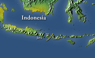
The Lombok Strait, is a strait of the Bali Sea connecting to the Indian Ocean, and is located between the islands of Bali and Lombok in Indonesia. The Gili Islands are on the Lombok side.

<span class="mw-page-title-main">Territorial waters</span> Coastal waters that are part of a sovereign states sovereign territory

Territorial waters are informally an area of water where a sovereign state has jurisdiction, including internal waters, the territorial sea, the contiguous zone, the exclusive economic zone, and potentially the extended continental shelf. In a narrower sense, the term is often used as a synonym for the territorial sea.

<span class="mw-page-title-main">Nusantara (term)</span> Sociopolitical term for Maritime Southeast Asia

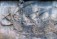
Nusantara is the Indonesian name of Maritime Southeast Asia. It is an Old Javanese term that literally means "outer islands". In Indonesia, it is generally taken to mean the Indonesian Archipelago. Outside of Indonesia, the term has been adopted to refer the Malay Archipelago.

<span class="mw-page-title-main">Law of the sea</span> International law concerning maritime environments

Law of the sea is a body of international law governing the rights and duties of states in maritime environments. It concerns matters such as navigational rights, sea mineral claims, and coastal waters jurisdiction.

Freedom of navigation (FON) is a principle of law of the sea that ships flying the flag of any sovereign state shall not suffer interference from other states, apart from the exceptions provided for in international law. In the realm of international law, it has been defined as “freedom of movement for vessels, freedom to enter ports and to make use of plant and docks, to load and unload goods and to transport goods and passengers". This right is now also codified as Article 87(1)a of the 1982 United Nations Convention on the Law of the Sea.

<span class="mw-page-title-main">Internal waters</span>

According to the United Nations Convention on the Law of the Sea, a nation's internal waters include waters on the side of the baseline of a nation's territorial waters that is facing toward the land, except in archipelagic states. It includes waterways such as rivers and canals, and sometimes the water within small bays.

Ambalat is a sea block in the Celebes sea located off the east coast of Borneo. It lies to the east of the Indonesian province of North Kalimantan and to the south-east of the Malaysian state of Sabah, and it is the subject of a territorial dispute between the two nations. Malaysia refers to part of the Ambalat block as Block ND6 (formerly Block Y) and part of East Ambalat Block as Block ND7 (formerly Block Z). The deep sea blocks contain an estimated 62,000,000 barrels (9,900,000 m3) of oil and 348 million cubic meters of natural gas. Other estimates place it substantially higher: 764,000,000 barrels (121,500,000 m3) of oil and 3.96 × 10¹⁰ cubic meters (1.4 trillion cubic feet) of gas, in only one of nine points in Ambalat.

<span class="mw-page-title-main">Territorial claims in the Arctic</span>

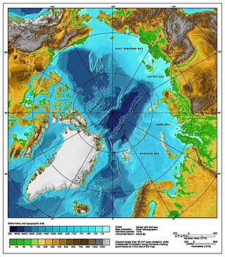
The Arctic consists of land, internal waters, territorial seas, exclusive economic zones (EEZs) and international waters above the Arctic Circle. All land, internal waters, territorial seas and EEZs in the Arctic are under the jurisdiction of one of the eight Arctic coastal states: Canada, Denmark, Finland, Iceland, Norway, Russia, Sweden and the United States. International law regulates this area as with other portions of Earth.

Maritime Security Regimes are codes and conventions of behavior agreed upon by coastal states to provide a degree of security within territorial waters and on the high seas.

The Indonesia–Singapore border is a maritime boundary in the Straits of Singapore between Indonesia's Riau Islands which lie to the south of the border, and the islands of Singapore which lie to the north. The Straits of Singapore is one of the region's busiest waterways as it is the main channel for Singapore's ports.

<span class="mw-page-title-main">Australia–Indonesia border</span> International maritime border between Australia and Indonesia

The Australia–Indonesia border is a maritime boundary running west from the two countries' tripoint maritime boundary with Papua New Guinea in the western entrance to the Torres Straits, through the Arafura Sea and Timor Sea, and terminating in the Indian Ocean. The boundary is, however, broken by the Timor Gap, where Australian and East Timorese territorial waters meet and where the two countries have overlapping claims to the seabed.

<span class="mw-page-title-main">Djuanda Kartawidjaja</span> Indonesian politician and technocrat (1911–1963)

Djuanda Kartawidjaja, more commonly referred to mononymously as Djuanda, was an Indonesian politician and technocrat who held various positions during the presidency of Sukarno, most notably as prime minister of Indonesia and a cabinet minister in several cabinets.

<span class="mw-page-title-main">Territorial disputes in the South China Sea</span> Disputes over ownership of islands in the South China Sea

Territorial disputes in the South China Sea involve conflicting island and maritime claims in the South China Sea by several sovereign states, namely the People's Republic of China (PRC), Taiwan, Brunei, Malaysia, the Philippines, and Vietnam. The disputes involve the islands, reefs, banks, and other features of the region, including the Spratly Islands, Paracel Islands, Scarborough Shoal, and various boundaries in the Gulf of Tonkin. The waters near the Indonesian Natuna Islands, which some regard as geographically part of the South China Sea, are disputed as well. Maritime disputes also extend beyond the South China Sea, as in the case of the Senkaku Islands and the Socotra Rock, which lie in the East China Sea.

An archipelagic state is an island country that consists of an archipelago. The designation is legally defined by the United Nations Convention on the Law of the Sea (UNCLOS). In various conferences, the Bahamas, Fiji, Indonesia, Papua New Guinea, and the Philippines are the five original sovereign states that obtained approval in the UNCLOS signed in Montego Bay, Jamaica on 10 December 1982 and qualified as the archipelagic states.

<span class="mw-page-title-main">Indonesia–Philippines relations</span> Bilateral relations

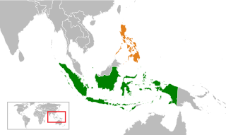
Indonesia–Philippine relations are the bilateral relations between Indonesia and the Philippines. The two countries established diplomatic relations on November 24, 1949. Since then, both countries enjoy cordial bilateral relationship in spirit of kinship. The two countries are considered allies and it is considered as one of the most important bilateral relationships in ASEAN. Both countries have established embassies in each capitals, Indonesia has their embassy in Manila and consulate general in Davao City, while the Philippines has their embassy in Jakarta and consulate general in Manado. High rank stately visits have been conducted for years.

The borders of Indonesia include land and maritime borders with Malaysia, Papua New Guinea, and East Timor, as well as shared maritime boundaries with Australia, India, Palau, Philippines, Singapore, Thailand, and Vietnam.

<span class="mw-page-title-main">Exclusive economic zone of India</span> Economic zone exclusive to India

India has the 18th-largest exclusive economic zone (EEZ) with a total size of 2,305,143 km2 (890,021 sq mi). It includes the Lakshadweep island group in the Laccadive Sea off the southwestern coast of India and the Andaman and Nicobar Islands in the Bay of Bengal and the Andaman Sea. India's EEZ is bordered to the west by Pakistan, to the south by the Maldives and Sri Lanka and to the east by Bangladesh, Myanmar, Thailand, Malaysia and Indonesia. Based on new scientific data, India has petitioned United Nations to extend its EEZ from 200 Nautical miles to 500 miles.

<span class="mw-page-title-main">Nusantara (planned city)</span> Capital city of Indonesia start in August 2024

Nusantara, officially the Capital City of Nusantara, is the future capital of Indonesia, scheduled to be inaugurated on 17 August 2024, coinciding with Indonesian Independence Day. Nusantara will replace Jakarta as the national capital, a position the latter city has held since the country's proclamation of independence in 1945.

<span class="mw-page-title-main">North Natuna Sea</span> Indonesian disputed territorial waters

The North Natuna Sea is a shallow body of water located north of Natuna Regency. Named by the Indonesian government in July 2017, Indonesia changed the northern part of its Exclusive Economic Zone in the South China Sea to the North Natuna Sea, bordering the southern part of Vietnam's Exclusive Economic Zone. The North Natuna Sea lies between the Natuna Islands and the Natuna Sea and Cape Cà Mau south of the Mekong Delta in Vietnam.

References

  1. "Swantara" (PDF). Lembaga Ketahanan Nasional (Lemhanas) (in Indonesian). December 2012. Retrieved 22 June 2020.
  2. 1 2 "Tujuan Wawasan Nusantara Sebagai Geopolitik Indonesia, Fungsi dan Dasar Pemikirannya". Liputan 6 (in Indonesian). 17 January 2019. Retrieved 21 August 2019.
  3. Pasaribu, Rowland B. F. "BAB 7 Wawasan Nusantara" (PDF). Universitas Gunadarma (in Indonesian). Retrieved 22 June 2020.
  4. Ika (10 January 2019). "Komunitas Geografi Usulkan Mata Pelajaran Geografi Diajarkan di Tingkat Dasar dan Menengah". Universitas Gadjah Mada (in Indonesian). Retrieved 22 June 2020.
  5. Echols, John M.; Shadily, Hassan (1989), Kamus Indonesia Inggris (An Indonesian-English Dictionary) (1st ed.), Jakarta: Gramedia, ISBN   979-403-756-7
  6. "Hasil Pencarian - KBBI Daring". kbbi.kemdikbud.go.id. Retrieved 2018-07-20.
  7. 1 2 Situmorang, Frederick (29 January 2013). "'Wawasan nusantara' vs UNCLOS". Jakarta Post. Jakarta. Retrieved 30 September 2015.
  8. Arum Sutrisni Putri (15 June 2020). "Asal Kata Wawasan Nusantara dan Arti Bagi Bangsa Indonesia". Kompas.com (in Indonesian).
  9. 1 2 Suradinata, Ermaya (2005). Hukum Dasar Geopolitik dan Geostrategi dalam Kerangka Keutuhan NKRI (in Indonesian). Jakarta: Suara Bebas. pp. 12–14.
  10. Hanggoro, Hendaru Tri. "Perintis Gagasan Wawasan Nusantara". Historia (in Indonesian). Retrieved 22 June 2020.
  11. Kulke, Hermann (2016). "Śrīvijaya Revisited: Reflections on State Formation of a Southeast Asian Thalassocracy". Bulletin de l'École française d'Extrême-Orient, Persee. 102: 45–95. doi:10.3406/befeo.2016.6231.
  12. 1 2 3 4 Sunardi, R.M. (2004). Pembinaan Ketahanan Bangsa dalam Rangka Memperkokoh Keutuhan Negara Kesatuan Republik Indonesia (in Indonesian). Jakarta: Kuaternita Adidarma. pp. 179–180. ISBN   9799824109.
  13. Damos Dumoli Agusman; Gulardi Nurbintoro (14 December 2019). "The archipelagic-state concept a quid pro quo". The Jakarta Post. Retrieved 22 June 2020.
  14. 1 2 3 Widoyo, Alfandi (2002). Reformasi Indonesia: Bahasan dari Sudut Pandang Geografi Politik dan Geopolitik (in Indonesian). Yogyakarta: Gadjah Mada University. ISBN   9794205168.
  15. 1 2 3 Sumarsono, S.; et al. (2001). Pendidikan Kewarganegaraan (in Indonesian). Jakarta: Gramedia Pustaka Utama. pp. 12–17.

See also