Related Research Articles
In computing, the Open Geospatial Consortium Web Feature Service (WFS) Interface Standard provides an interface allowing requests for geographical features across the web using platform-independent calls. One can think of geographical features as the "source code" behind a map, whereas the WMS interface or online tiled mapping portals like Google Maps return only an image, which end-users cannot edit or spatially analyze. The XML-based GML furnishes the default payload-encoding for transporting geographic features, but other formats like shapefiles can also serve for transport. In early 2006 the OGC members approved the OpenGIS GML Simple Features Profile. This profile is designed both to increase interoperability between WFS servers and to improve the ease of implementation of the WFS standard.
Olympique Gymnaste Club Nice Côte d'Azur, commonly referred to as OGC Nice or simply Nice, is a French professional football club based in Nice. The club was founded in 1904 and currently plays in Ligue 1, the top tier of French football. Nice plays its home matches at the Allianz Riviera.

The Office of Government Commerce (OGC) was a UK Government Office established as part of HM Treasury in 2000. It was moved into the Efficiency and Reform Group of the Cabinet Office in 2010, before being closed in 2011.
Keyhole Markup Language (KML) is an XML notation for expressing geographic annotation and visualization within two-dimensional maps and three-dimensional Earth browsers. KML was developed for use with Google Earth, which was originally named Keyhole Earth Viewer. It was created by Keyhole, Inc, which was acquired by Google in 2004. KML became an international standard of the Open Geospatial Consortium in 2008. Google Earth was the first program able to view and graphically edit KML files, but other projects such as Marble have added KML support.
A Web Map Service (WMS) is a standard protocol developed by the Open Geospatial Consortium in 1999 for serving georeferenced map images over the Internet. These images are typically produced by a map server from data provided by a GIS database.
A spatial database is a general-purpose database that has been enhanced to include spatial data that represents objects defined in a geometric space, along with tools for querying and analyzing such data. Most spatial databases allow the representation of simple geometric objects such as points, lines and polygons. Some spatial databases handle more complex structures such as 3D objects, topological coverages, linear networks, and triangulated irregular networks (TINs). While typical databases have developed to manage various numeric and character types of data, such databases require additional functionality to process spatial data types efficiently, and developers have often added geometry or feature data types. The Open Geospatial Consortium (OGC) developed the Simple Features specification and sets standards for adding spatial functionality to database systems. The SQL/MM Spatial ISO/IEC standard is a part the SQL/MM multimedia standard and extends the Simple Features standard with data types that support circular interpolations.
The OGC Reference Model describes a framework for the ongoing work of the Open Geospatial Consortium (OGC) and their specifications and implementing interoperable solutions and applications for geospatial services, data, and applications. It is not an OGC standard.
Mapbender is a graduated project of the Open Source Geospatial Foundation. It was awarded OGC web site of the month in 2008. It is used by PortalU and several federal states to implement the INSPIRE regulation. Many municipalities use Mapbender as City Map Services and it is used as the mapping framework for online cycle route planners.
The OGC Web Processing Service (WPS) Interface Standard provides rules for standardizing inputs and outputs for invoking geospatial processing services, such as polygon overlay, as a web service. The WPS standard defines how a client can request the execution of a process, and how the output from the process is handled. It defines an interface that facilitates the publishing of geospatial processes and clients’ discovery of and binding to those processes. The data required by the WPS can be delivered across a network or they can be available at the server. WPS can describe any calculation including all of its inputs and outputs, and trigger its execution as a web service. WPS supports simultaneous exposure of processes via HTTP GET, HTTP POST, and SOAP, thus allowing the client to choose the most appropriate interface mechanism. The specific processes served up by a WPS implementation are defined by the owner of that implementation. Although WPS was designed to work with spatially referenced data, it can be used with any kind of data.
The Open Geospatial Consortium Web Coverage Service Interface Standard (WCS) defines Web-based retrieval of coverages – that is, digital geospatial information representing space/time-varying phenomena.
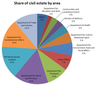
The public estate in the United Kingdom is the collection of all government-owned real property assets in the United Kingdom. The Office for National Statistics estimated in 2008 that the public estate has a book value of £380 billion, which is about £6,000 for every UK resident. Of this, approximately £240 billion is held by local government, while the rest—£130 billion—is held by the central government and public corporations.
Pennsylvania Governor's Office of General Counsel is an executive-level agency in Pennsylvania providing legal services to all executive agencies, boards, and commissions and select independent agencies of the Government of Pennsylvania. It is governed by the Commonwealth Attorneys Act of 1980.
The Open Geospatial Consortium (OGC), an international voluntary consensus standards organization, originated in 1994. In the OGC, more than 500 commercial, governmental, nonprofit and research organizations collaborate in a consensus process encouraging development and implementation of open standards for geospatial content and services, sensor web and Internet of Things, GIS data processing and data sharing.
The Sensor Observation Service (SOS) is a web service to query real-time sensor data and sensor data time series and is part of the Sensor Web. The offered sensor data consists of data directly from the sensors, which are encoded in the Sensor Model Language (SensorML), and the measured values in the Observations and Measurements encoding format. The web service as well as both file formats are open standards and specifications of the same name defined by the Open Geospatial Consortium (OGC).
WaterML is a technical standard and information model used to represent hydrological time series structures. The current version is WaterML 2.0, released an open standard of the Open Geospatial Consortium (OGC).
The Web Coverage Processing Service (WCPS) defines a language for filtering and processing of multi-dimensional raster coverages, such as sensor, simulation, image, and statistics data. The Web Coverage Processing Service is maintained by the Open Geospatial Consortium (OGC). This raster query language allows clients to obtain original coverage data, or derived information, in a platform-neutral manner over the Web.
The Information Technology Infrastructure Library (ITIL) is a set of detailed practices for IT activities such as IT service management (ITSM) and IT asset management (ITAM) that focus on aligning IT services with the needs of business.
A GeoPackage (GPKG) is an open, non-proprietary, platform-independent and standards-based data format for geographic information system implemented as a SQLite database container. Defined by the Open Geospatial Consortium (OGC) with the backing of the US military and published in 2014, GeoPackage has seen widespread support from various government, commercial, and open source organizations.
SensorThings API is an Open Geospatial Consortium (OGC) standard providing an open and unified framework to interconnect IoT sensing devices, data, and applications over the Web. It is an open standard addressing the syntactic interoperability and semantic interoperability of the Internet of Things. It complements the existing IoT networking protocols such CoAP, MQTT, HTTP, 6LowPAN. While the above-mentioned IoT networking protocols are addressing the ability for different IoT systems to exchange information, OGC SensorThings API is addressing the ability for different IoT systems to use and understand the exchanged information. As an OGC standard, SensorThings API also allows easy integration into existing Spatial Data Infrastructures or Geographic Information Systems.
The 2021–22 season was the 95th season in the existence of OGC Nice and the club's 20th consecutive season in the top flight of French football. In addition to the domestic league, Nice participated in this season's edition of the Coupe de France.
References
- ↑ "Glossary of Terms - W - OGC". www.opengeospatial.org.
| | This Web-software-related article is a stub. You can help Wikipedia by expanding it. |