Woods Hole, Massachusetts

Last updated

Woods Hole, Massachusetts
Marine Biological Laboratory, Woods Hole by Pam Wilmot.jpg
Barnstable County Massachusetts incorporated and unincorporated areas Woods Hole highlighted.svg
Location in Barnstable County and the state of Massachusetts.
Coordinates: 41°31′36″N70°39′47″W / 41.52667°N 70.66306°W / 41.52667; -70.66306
Country United States
State Massachusetts
County Barnstable
Town Falmouth
Area
[1]
  Total3.93 sq mi (10.19 km2)
  Land2.13 sq mi (5.53 km2)
  Water1.80 sq mi (4.66 km2)
Elevation
20 ft (6 m)
Population
 (2020)
  Total834
  Density390.63/sq mi (150.79/km2)
Time zone UTC-5 (Eastern (EST))
  Summer (DST) UTC-4 (EDT)
ZIP code
02543
Area code 508
FIPS code 25-81245
GNIS feature ID0617060

Woods Hole is a census-designated place in the town of Falmouth in Barnstable County, Massachusetts, United States. It lies at the extreme southwestern corner of Cape Cod, near Martha's Vineyard and the Elizabeth Islands. The population was 781 at the 2010 census. [2]

Contents

It is the site of several marine science institutions, including Woods Hole Oceanographic Institution, the Marine Biological Laboratory, the Woodwell Climate Research Center, NOAA's Northeast Fisheries Science Center (which started the Woods Hole scientific community in 1871), the Woods Hole Science Aquarium, a USGS coastal and marine geology center, and the home campus of the Sea Education Association.

Woods Hole is also the site of United States Coast Guard Sector Southeastern New England (formerly USCG Group Woods Hole), [3] the Nobska Light lighthouse, and the terminus of the Steamship Authority ferry route between Cape Cod and the island of Martha's Vineyard.

History

Pacific Guano Works, Woods Hole, ca.1860s; engraving by S.S. Kilburn PacificGuanoWorks WoodsHole bySSKilburn ca1865.png
Pacific Guano Works, Woods Hole, ca.1860s; engraving by S.S. Kilburn

Historically, Woods Hole included one of the few good harbors (along with Hyannis) on the southern side of Cape Cod (i.e. Great Harbor, contained by Penzance Point). The community became a center for whaling, shipping, and fishing, prior to its dominance today by tourism and marine research. At the end of the nineteenth century, Woods Hole was the home of the Pacific Guano Company, which produced fertilizer from guano imported from islands in the Pacific Ocean, the Caribbean, and the coast of South Carolina. After the firm went bankrupt in 1889, Long Neck – the peninsula on which their factory was located – was renamed Penzance Point and was developed with shingle-style summer homes for bankers and lawyers from New York and Boston. Notable property owners on Penzance Point at the beginning of the twentieth century included Seward Prosser of New York's Bankers Trust Company; Francis Bartow, a partner in J. P. Morgan and Company; Joseph Lee, a partner in Lee, Higginson & Co.; and Franklin A. Park, an executive of Singer Sewing Machine. Other notable businessmen established homes on Gansett Point, Nobska Point, and at Quissett Harbor, further from the village center. Irving Langmuir, the famous Scientist, also lived in Woods Hole and died there on August 16, 1957. Before 1898, the Woods Hole Yacht Club was formed. In 1899, the Woods Hole Golf course was started. Around 1919, it was expanded to 18 holes. In 1976, The Woods Hole Foundation was created. The eminent Hungarian born biochemist and Nobel prize laureate, Albert Imre Szent-Györgyi de Nagyrápolt died in Woods Hole in 1986.

Geography

Woods Hole is located at the southwestern tip of the town of Falmouth (and of Cape Cod) at 41°31′36″N70°39′47″W / 41.52667°N 70.66306°W / 41.52667; -70.66306 (41.526730, -70.663184). [4] The term "Woods Hole" refers to a strait named Woods Hole, which separates Cape Cod from the Elizabeth Islands (specifically, Uncatena Island and Nonamesset Island) and which boats, yachts, and small ferries can use to travel between Vineyard Sound and Buzzards Bay. The strait is known for its extremely strong current, approaching four knots. [5] It is one of four straits allowing maritime passage between Buzzards Bay and Vineyard Sound; the others are Canapitsit Channel, Quick's Hole and Robinson's Hole. Published yearly is the Eldridge Tide and Pilot Book, which has a detailed reference section showing the complex pattern of tides and currents. Ferries operated by The Woods Hole, Martha's Vineyard and Nantucket Steamship Authority run regularly between Woods Hole and Martha's Vineyard. The present Woods Hole, Martha's Vineyard and Nantucket Steamship Authority was formed from the New Bedford, Martha's Vineyard, and Nantucket Steamboat Company, which in turn was a consolidation of earlier companies dating to the early 19th century, just before the railroad arrived. [6] [ circular reference ]

Nobska Light NobskaLight.jpg
Nobska Light
A view of downtown Woods Hole from the water, including MBL and WHOI buildings Woods Hole, MA from the water.jpg
A view of downtown Woods Hole from the water, including MBL and WHOI buildings

Much of Woods Hole centers around the enclosed harbor of Eel Pond. The Eel Pond Bridge, a bascule drawbridge at the mouth of the harbor, allows boats to enter and exit the harbor according to a fixed schedule posted on the side of the bridge.

Nobska Light, a lighthouse at Nobska Point, is operated by the United States Coast Guard, and the accompanying house is the home of the commander of the Coast Guard base at Little Harbor.

The local landmark The Knob is a rocky outcropping that overlooks Buzzards Bay and Quisset Harbor. It is a part of the privately owned Salt Pond bird sanctuaries.

According to the United States Census Bureau, the Woods Hole CDP has a total area of 3.9 square miles (10.1 km2), of which 2.1 square miles (5.5 km2) is land and 1.8 square miles (4.6 km2) (45.24%) is water. [2]

Climate

Climate data for Woods Hole, Falmouth, Massachusetts (1991–2020 normals)
MonthJanFebMarAprMayJunJulAugSepOctNovDecYear
Mean daily maximum °F (°C)39.1
(3.9)
40.5
(4.7)
44.7
(7.1)
54.8
(12.7)
64.0
(17.8)
72.4
(22.4)
79.2
(26.2)
79.0
(26.1)
72.8
(22.7)
62.5
(16.9)
53.3
(11.8)
44.7
(7.1)
58.9
(14.9)
Daily mean °F (°C)32.1
(0.1)
33.0
(0.6)
37.2
(2.9)
46.9
(8.3)
56.1
(13.4)
65.0
(18.3)
71.8
(22.1)
71.8
(22.1)
66.0
(18.9)
55.8
(13.2)
46.4
(8.0)
38.2
(3.4)
51.7
(10.9)
Mean daily minimum °F (°C)25.1
(−3.8)
25.4
(−3.7)
29.7
(−1.3)
39.1
(3.9)
48.1
(8.9)
57.6
(14.2)
64.4
(18.0)
64.5
(18.1)
59.1
(15.1)
49.1
(9.5)
39.6
(4.2)
31.6
(−0.2)
44.4
(6.9)
Source: NOAA [7]

Falmouth Road Race

The annual Falmouth Road Race brings thousands of runners to Woods Hole in August each year. The route of the 7-mile (11 km) race starts outside the front door of the Captain Kidd tavern and follows the shore of Vineyard Sound through Falmouth to Shipwrecked (historically, the British Beer Company, which closed due to COVID-19), another tavern, in Falmouth Heights. [8] [9]

Education

The Woods Hole School is the home of the Children's School of Science. Founded in 1913, this institution (locally known as "CSS" and "Science School") provides science classes for students between seven and 16 years old that focus on scientific investigation by observation. Students regularly visit ecosystems around the village to study the organisms in their natural environments, such as the Sippewissett Salt Marsh. The Children's School of Science draws upon the talent brought to the village by the research institutions but also educates the children of both scientists and locals. Some mention of the Woods Hole Oceanographic Institution is made in the 1975 blockbuster film Jaws as having been the center of research for the fictional character Matt Hooper. Hooper is described as a marine biologist, focusing on the study of sharks. Coincidentally, a great white shark was spotted some years later near Woods Hole in September 2004.

Woods Hole is part of the Falmouth public school district, served by Mullen-Hall Elementary, Morse Pond Middle School, Lawrence Junior High School, and Falmouth High School. [10] Woods Hole students also often attend Upper Cape Cod Regional Technical High School, Sturgis Charter Public School, and Falmouth Academy.[ citation needed ]

Demographics

Historical population
CensusPop.Note
2020 834
U.S. Decennial Census [11]

As of the census [12] of 2000, there were 925 people, 459 households, and 212 families residing in the CDP. The population density was 165.3/km2 (427.9/mi2). There were 942 housing units at an average density of 168.4/km2 (435.8/mi2). The racial makeup of the CDP was 94.70% White, 1.62% African American, 0.54% Native American, 1.84% Asian, 0.22% from other races, and 1.08% from two or more races. Hispanic or Latino of any race were 0.97% of the population.

There were 459 households, out of which 14.8% had children under the age of 18 living with them, 39.7% were married couples living together, 5.4% had a female householder with no husband present, and 53.6% were non-families. 40.5% of all households were made up of individuals, and 17.9% had someone living alone who was 65 years of age or older. The average household size was 1.94 and the average family size was 2.58.

In the CDP, the population was spread out, with 13.5% under the age of 18, 7.1% from 18 to 24, 25.7% from 25 to 44, 26.4% from 45 to 64, and 27.2% who were 65 years of age or older. The median age was 48 years. For every 100 females, there are 94.7 males. For every 100 females age 18 and over, there were 88.7 males.

The median income for a household in the CDP was $47,604, and the median income for a family was $57,969. Males had a median income of $31,964 versus $31,875 for females. The per capita income for the CDP was $30,752. None of the families and 5.3% of the population were living below the poverty line, including no under 18 and 6.4% of those over 64.

See also

Related Research Articles

<span class="mw-page-title-main">Cape Cod</span> Cape in the northeastern United States

Cape Cod is a peninsula extending into the Atlantic Ocean from the southeastern corner of Massachusetts, in the northeastern United States. Its historic, maritime character and ample beaches attract heavy tourism during the summer months. The name Cape Cod, coined in 1602 by Bartholomew Gosnold, is the ninth oldest English place-name in the U.S.

<span class="mw-page-title-main">Nantucket</span> Island, town, and county in Massachusetts, United States

Nantucket is an island about 30 miles (48 km) south from Cape Cod. Together with the small islands of Tuckernuck and Muskeget, it constitutes the Town and County of Nantucket, a combined county/town government in the state of Massachusetts. Nantucket is the southeasternmost town in both Massachusetts and the New England region.

<span class="mw-page-title-main">Chilmark, Massachusetts</span> Town in Massachusetts, United States

Chilmark is a town located on Martha's Vineyard in Dukes County, Massachusetts, United States. The population was 1,212 at the 2020 census. The fishing village of Menemsha is located on the western side of the town along its border with the town of Aquinnah. Chilmark had the highest median home sale price of any town or city in Massachusetts in 2013.

<span class="mw-page-title-main">Edgartown, Massachusetts</span> Town in Massachusetts, United States

Edgartown is a town on the island of Martha's Vineyard in Dukes County, Massachusetts, United States, for which it is the county seat. The town's population was 5,168 at the 2020 census.

<span class="mw-page-title-main">Oak Bluffs, Massachusetts</span> Town in Massachusetts, United States

Oak Bluffs is a town located on the island of Martha's Vineyard in Dukes County, Massachusetts, United States. The population was 5,341 at the 2020 United States Census. It is one of the island's principal points of arrival for summer tourists, and is noted for its "gingerbread cottages" and other well-preserved mid- to late-nineteenth-century buildings. The town has been a historically important center of African American culture since the eighteenth century.

<span class="mw-page-title-main">Tisbury, Massachusetts</span> Town in Massachusetts, United States

Tisbury is a town located on Martha's Vineyard in Dukes County, Massachusetts, United States. The population was 4,815 at the 2020 census.

<span class="mw-page-title-main">Bourne, Massachusetts</span> Town in Massachusetts, United States

Bourne is a town in Barnstable County, Massachusetts, United States. The population was 20,452 at the 2020 census.

<span class="mw-page-title-main">Falmouth, Massachusetts</span> Town in Massachusetts, United States

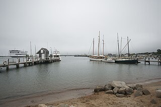
Falmouth is a town in Barnstable County, Massachusetts, United States. The population was 32,517 at the 2020 census, making Falmouth the second-largest municipality on Cape Cod after Barnstable. The terminal for the Steamship Authority ferries to Martha's Vineyard is located in the village of Woods Hole in Falmouth. Woods Hole also contains several scientific organizations such as the Woods Hole Oceanographic Institution (WHOI), the Marine Biological Laboratory (MBL), the Woodwell Climate Research Center, NOAA's Woods Hole Science Aquarium, and the scientific institutions' various museums.

<span class="mw-page-title-main">Hyannis, Massachusetts</span> Village in Massachusetts, United States

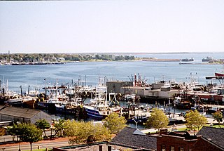
Hyannis is the largest of the seven villages in the town of Barnstable, Massachusetts, United States. It is the commercial and transportation hub of Cape Cod and was designated an urban area at the 1990 census. Because of this, many refer to Hyannis as the "Capital of the Cape". It contains a majority of the Barnstable Town offices and two important shopping districts: the historic downtown Main Street and the Route 132 Commercial District, including Cape Cod Mall and Independence Park, headquarters of Cape Cod Potato Chips. Cape Cod Hospital in Hyannis is the largest on Cape Cod.

<span class="mw-page-title-main">Elizabeth Islands</span> Island group in Massachusetts, USA

The Elizabeth Islands are a chain of over 20 small islands extending southwest from the southern coast of Cape Cod, Massachusetts in the United States.They are located at the outer edge of Buzzards Bay, north of Martha's Vineyard, from which they are separated by Vineyard Sound, and constitute the town of Gosnold in Dukes County, Massachusetts.

<span class="mw-page-title-main">Nantucket Sound</span> A roughly triangular area of the Atlantic Ocean offshore from the U.S. state of Massachusetts

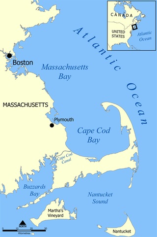
Nantucket Sound is a roughly triangular area of the Atlantic Ocean offshore from the U.S. state of Massachusetts. It is 30 miles (48 km) long and 25 miles (40 km) wide, and is enclosed by Cape Cod on the north, Nantucket on the south, and Martha's Vineyard on the west. Between Cape Cod and Martha's Vineyard it is connected to the Vineyard Sound. Ports on Nantucket Sound include Nantucket and Hyannis, Massachusetts.

<span class="mw-page-title-main">Nobska Light</span> Lighthouse near Woods Hole, Massachusetts, US

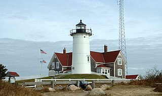
Nobska Light, originally called Nobsque Light, also known as Nobska Point Light is a lighthouse located near the division between Buzzards Bay, Nantucket Sound, and Vineyard Sound in the settlement of Woods Hole, Massachusetts on the southwestern tip of Cape Cod, Massachusetts. It overlooks Martha's Vineyard and Nonamesset Island. The light station was established in 1828, with the tower protruding above the keeper's house, and was replaced in 1876 by the current 42 foot tall iron tower. The light station was added to the National Register of Historic Places as Nobska Point Light Station in 1987.

<span class="mw-page-title-main">Steamship Authority</span> Regulatory body for ferry operations in Massachusetts

The Woods Hole, Martha's Vineyard and Nantucket Steamship Authority, doing business as The Steamship Authority (SSA), is the statutory regulatory body for all ferry operations between mainland Massachusetts and the islands of Martha's Vineyard and Nantucket, as well an operator of ferry services between the mainland and the islands. It is the only ferry operator to carry automobiles to and from the islands. The Authority also operates several freight vessels, thus serving as the main link for shipping any commercial goods that are not transported using the airports on Nantucket or Martha's Vineyard.

The Falmouth Road Race is an annual 7.0-mile (11.3 km) road race on Cape Cod from Woods Hole, a village in the town of Falmouth, Massachusetts, to Falmouth Heights.

<span class="mw-page-title-main">Southeastern Massachusetts</span> Region of Massachusetts in the United States

Southeastern Massachusetts is a region of Massachusetts located south of Boston and east of Rhode Island. It is commonly used to describe areas with cultural ties to both Boston and Providence, Rhode Island, and includes the cities of New Bedford and Fall River and their respective suburbs. Despite the location of Cape Cod and the islands to its south, which are the southeasternmost parts of the state, they are not often grouped in this designation. At its broadest definition, it includes all of Massachusetts south of Boston, southeast of Worcester, and east of Providence, Rhode Island, while at its narrowest definition, it is Bristol County and the Western portion of Plymouth County.

<span class="mw-page-title-main">Hy-Line Cruises</span>

Hy-Line Cruises is a family owned and operated Massachusetts ferry and cruise company. The company currently operates the second largest passenger ferry service between mainland Cape Cod and the islands of Martha's Vineyard and Nantucket. The company also operates sightseeing cruises and fishing charters. The company's main office is located at 22 Channel Point Road in Hyannis.

<span class="mw-page-title-main">Woods Hole station</span>

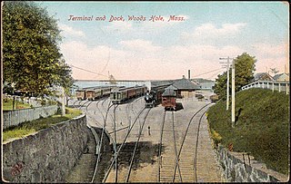
Woods Hole station was a station on the Old Colony Railroad located in the village of Woods Hole in the town of Falmouth, Massachusetts. It served as the terminus for the railroad's branch line to Woods Hole and offered ferry connections to Martha's Vineyard and Nantucket.

<i>Nobska</i> (steamship)

The Nobska was a steamship that plied the waters of Nantucket Sound as part of The Woods Hole, Martha's Vineyard and Nantucket Steamship Authority's fleet between 1925 and 1973 as a ferry. She was eventually scrapped in 2006 despite efforts to save her. She was America's last East Coast coastal steamer, had been on the National Register of Historic Places in Maryland, and had been considered one of America's 10 most endangered maritime resources by the National Maritime Alliance and National Trust for Historic Preservation.

<span class="mw-page-title-main">North Falmouth station</span>

North Falmouth station was a railroad station on the Old Colony Railroad on Depot Road in North Falmouth, Massachusetts. Service to the station began in 1872 and ended in 1964, and the station burned down in 1969.

<i>Cape Codder</i> (NH train) Defunct passenger train in the United States

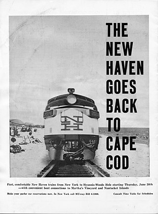
The Cape Codder was a pair of day and night passenger trains run by the New York, New Haven and Hartford Railroad (NH) from the latter 1920s to the mid 1960s, with some brief interruptions. Its distinction was the longest tenure of direct summertime New York City to Cape Cod trains. With the improvement of highways in southeastern Massachusetts, passenger rail traffic diminished, and the Cape Codder service ended with the New Haven Railroad's discontinuing of passenger rail service to Cape Cod.

References

  1. "2020 U.S. Gazetteer Files". United States Census Bureau. Retrieved May 21, 2022.
  2. 1 2 "Geographic Identifiers: 2010 Demographic Profile Data (G001): Woods Hole CDP, Massachusetts". U.S. Census Bureau, American Factfinder. Archived from the original on February 12, 2020. Retrieved December 16, 2013.
  3. "Homeport: Port Directory". Archived from the original on September 30, 2013. Retrieved September 30, 2013.
  4. "US Gazetteer files: 2010, 2000, and 1990". United States Census Bureau. February 12, 2011. Retrieved April 23, 2011.
  5. "Woods Hole, Massachusetts Current (Use with caution)". Archived from the original on May 11, 2007. Retrieved May 23, 2006.
  6. The Woods Hole, Martha's Vineyard and Nantucket Steamship Authority
  7. "NowData – NOAA Online Weather Data". National Oceanic and Atmospheric Administration . Retrieved August 28, 2022.
  8. "Race History". Falmouth Road Race. Retrieved January 28, 2020.
  9. "Race Day". Falmouth Road Race. Retrieved January 28, 2020.
  10. "Falmouth Public Schools: District Information" . Retrieved January 19, 2016.
  11. "Census of Population and Housing". Census.gov. Retrieved June 4, 2016.
  12. "U.S. Census website". United States Census Bureau . Retrieved January 31, 2008.