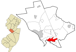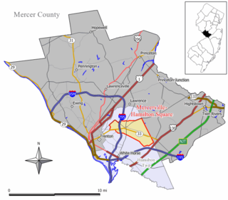
Mercerville-Hamilton Square is a census-designated place and unincorporated community located within Hamilton Township, in Mercer County, New Jersey, United States. As of the 2000 United States Census, the CDP's population was 26,419. As part of the 2010 Census, the area was split into two CDPs, Mercerville and Hamilton Square.

Princeton North, also known as North Princeton, is an unincorporated community that is located in Princeton, in Mercer County, New Jersey, United States. As of the 2000 Census, the CDP population was 4,528. While the area was categorized as a census-designated place in the 2000 Census, the CDP status was eliminated by the United States Census Bureau as of the 2010 Census. The community is located in what was formerly Princeton Township.

White Horse is an unincorporated community and census-designated place (CDP) located within Hamilton Township, in Mercer County, New Jersey, United States. As of the 2010 United States Census, the CDP's population was 9,494.

Yardville-Groveville was an unincorporated community and census-designated place (CDP) located within Hamilton Township, in Mercer County, New Jersey, United States. As of the 2000 United States Census, the CDP's population was 9,208.
Columbia is an unincorporated community and census-designated place (CDP) located within Knowlton Township in Warren County, New Jersey, United States. While the community has existed for over a century, the CDP was created as part of the 2010 United States Census. As of the 2010 Census, the CDP's population was 229. The area is served as United States Postal Service ZIP Code 07832.

Robbinsville is a census-designated place (CDP) located within Robbinsville Township in Mercer County, New Jersey, United States. The area is served as United States Postal Service ZIP Code 08691. As of the 2010 United States Census, the population for the CDP was 3,041.

Groveville is an unincorporated community and census-designated place (CDP) located within Hamilton Township, in Mercer County, New Jersey, United States. As of the 2010 United States Census, the CDP's population was 2,945. Before the 2010 Census, the area was part of the Yardville-Groville CDP.

Mercerville is an unincorporated community and census-designated place (CDP) located within Hamilton Township, in Mercer County, New Jersey, United States. As of the 2010 United States Census, the CDP's population was 13,230. Until after the 2000 Census, the area was part of the Mercerville-Hamilton Square CDP. For the 2010 Census it was split into two CDPs, Mercerville and Hamilton Square.

Hamilton Square is an unincorporated community and census-designated place (CDP) located within Hamilton Township, in Mercer County, New Jersey, United States, that is the site of a historic colonial village. Until the 2000 Census the area was part of the Mercerville-Hamilton Square CDP, which was split into two CDPs as of 2010: Mercerville and Hamilton Square. As of the 2010 United States Census, the CDP's population was 12,784.

Marksboro is an unincorporated community and census-designated place (CDP) located within Frelinghuysen Township in Warren County, New Jersey, United States, that was created as part of the 2010 United States Census, though settlement and naming of the community date back to before 1760. As of the 2010 Census, the CDP's population was 82.

Anderson is a Census-designated place located within Mansfield Township, in Warren County, New Jersey, United States, that was created as part of the 2010 United States Census. As of the 2010 United States Census, the CDP's population was 342.
Blairstown is an unincorporated community and census-designated place (CDP) located within Blairstown Township, in Warren County, New Jersey, United States, that was created as part of the 2010 United States Census. As of the 2010 United States Census, the CDP's population was 515.
Broadway is an unincorporated community and census-designated place (CDP) located within Franklin Township, in Warren County, New Jersey, United States, that was created as part of the 2010 United States Census. As of the 2010 Census, the CDP's population was 244.
Upper Stewartsville is an unincorporated community and census-designated place (CDP) located within Greenwich Township in Warren County, New Jersey, United States, that was defined as part of the 2010 United States Census. As of the 2010 Census, the CDP's population was 212.
Hutchinson is an unincorporated community and census-designated place (CDP) located within Harmony Township in Warren County, New Jersey, United States, that was defined as part of the 2010 United States Census. As of the 2010 Census, the CDP's population was 135.
Hope is an unincorporated community and census-designated place (CDP) located within Hope Township in Warren County, New Jersey, United States, that was defined as part of the 2010 United States Census. As of the 2010 Census, the CDP's population was 195.
Mount Hermon is an unincorporated community and census-designated place (CDP) located within Hope Township in Warren County, New Jersey, United States, that was defined as part of the 2010 United States Census. As of the 2010 Census, the CDP's population was 141.
Silver Lake is an unincorporated community and census-designated place (CDP) located within Hope Township in Warren County, New Jersey, United States, that was defined as part of the 2010 United States Census. As of the 2010 Census, the CDP's population was 368.
Mountain Lake is an unincorporated community and census-designated place (CDP) located within Liberty Township in Warren County, New Jersey, United States, that was created as part of the 2010 United States Census. As of the 2010 Census, the CDP's population was 575.
Upper Pohatcong is an unincorporated community and census-designated place (CDP) located within Pohatcong Township in Warren County, New Jersey, United States, that was defined as part of the 2010 United States Census. As of the 2010 Census, the CDP's population was 1,781.