Related Research Articles

Chin State is a state in western Myanmar. Chin State is bordered by Sagaing Division and Magway Division to the east, Rakhine State to the south, the Chittagong Division of Bangladesh to the west, and the Indian states of Mizoram to the west and Manipur to the north. The population of Chin State is about 478,801 according to the 2014 census, and its capital city is Hakha.
The Mizo people, historically recorded as the Lushais, are an ethnic group native to the state of Mizoram in India and neighbouring states of Northeast India. The majority of Mizos outside of India reside in the town of Kalay in Myanmar, making up 55% of the town's population. They speak the Tibeto-Burman language of Mizo, the official language and lingua franca of Mizoram. The state has one of the highest literacy rates in India, at more than 90%.

The Chin people are an ethnic group native to the Chin State and Rakhine State of Myanmar. Strictly speaking, the term "Chin" only refers to the 53 sub-tribes of the Chin ethnic group, divided and recognized by the Burmese government. They speak the Kuki-Chin-Mizo languages, which are often mutually unintelligible but are closely related.

The Kuki people are an ethnic group in the Northeastern Indian states of Manipur, Nagaland, Assam, Meghalaya, Tripura and Mizoram, as well as the neighbouring countries of Bangladesh and Myanmar. The Kuki constitute one of several hill tribes within India, Bangladesh, and Myanmar. In Northeast India, they are present in all states except Arunachal Pradesh.

The Sizang, Siyin or Taute people are primarily the descendants of Pu Thuantak, also known as Suantak in the Tedim language and by related clans, and their adopted sons and daughters. The Siyin Valley is in present-day Chin State, Myanmar, and was settled by descendants of the Pu Thuantak who moved from their original home of Ciimnuai with other Zo (Chin) people such as the Sukte, Thado, Zou, and other related tribes.
Falam is a town in north-western Burma (Myanmar) near Burma's western border with the Indian state of Mizoram. The town was founded by Taisun tribe. The British arrived to Falam in 1892, and became an important base for British rule of the Chin Hills. After the formation of Chin State, it was the capital city until the administrative offices were moved to Hakha in 1974. It is still the regional governor of Falam District and of Falam Township. Falam is the headquarters of several important organizations, such as the Chin Baptist Convention (CBC). The population, as of 2014, is 9,092.

The Zou people are an indigenous community living along the frontier of India and Burma, they are a sub-group of the Kuki people. In India, they live with and are similar in language and habits to the Thadou people and Paite and the Simte peoples. In Burma, the Zou are counted among the Chin people.They are a hill people, "Zou" may plainly means "Hills" denoting the Zous are "people of the hills" or "of the hills", and "Zou" has also a different meaning in Zou language that is "complete" or another word for it is "finish". But, the Zou people believed that they incepted the name 'Zou' from their forefather 'Zou' or 'Zo', believed to be the progenitor of the broad Chin-Kuki-Mizo people.

Vangte or Vangteh is a large village in southern Tedim Township, Falam District, Chin State, in Myanmar. Vangteh is also the name of the village tract where Vangte lies.
Guite is the progenitor clan of Zomi people. He is also said to be the Older Brother of Thadou progenitor of the Thadou people. Mostly the Guite clan speak Paite language. Some known as Zomi and few also as Kuki in India and as Chin in Myanmar (Burma). Depending on local pronunciation, the clan was also called differently such as Nguite, Vuite, and was also recorded even as Gwete, Gwite, Nwite. In accord with the claim of their solar origin, the Guite clan has been called nampi, meaning noble or major or even dominant people, of the region in local dialect in the past.

Falam Township is a township of Falam District in the Chin State of Burma (Myanmar). Its administrative seat is the town of Falam. The population, as of 2014, is 41,457. Out of this population, 9,092 live in Falam town and 32,365 live in rural areas.

Thantlang Township is one of the nine townships in Chin State. Thantlang is the administrative town of inclusive nine circles attributed to the geographical and dialectical arrangements of the area. They are Khualhring Tlang, Vanzang Tlang, Zahnak Tlang, Bual Tlang, VaiLam Tlang Lautu Tlang, Mara Tlang, Vailam Tlang, Zophei Tlang and Bawipa Tlang(Bawipa circle). Only four circles speak Lai dialect. Zophei(Zophei and Bawipa circles), Lautu(Lautu circle), HawThai(Mara circle) speak their tribal language. The other fives circles and in Thantlang town speak Lai dialect. In Thantlang township, Lai dialect is the common use dialect. Lai dialect is also spoken at Hakha township and Falam township.
The Daai are an ethnic group living in Chin State, Myanmar. The Daai consist of 32 Chin tribes, which have been registered by the Government of Burma since 1890. The recent Military Regime’s census mentions the Daai tribe as the 62nd of 135 tribes of Burma. Researchers refer to them as the Daai group in the ethnic survey book of Burma. The Daai Chin appear to be of Mongolian, Indo-Chinese, and Tibeto-Burman descent. The Daai people live in the Mindat, Paletwa, Matupi and Kanpetlet townships of Southern Chin State in Burma. There are more than 180 Daai villages with a total population of somewhere between 40,000 and 50,000. Their population makes the Daai-Chin the majority tribe of the Southern Chin Hills.
The Kuki-Chin languages are a branch of 50 or so Sino-Tibetan languages spoken in northeastern India, western Myanmar and southeastern Bangladesh. Most speakers of these languages are known as Mizo in Mizoram and Manipur. Also, as Kukī in Assamese and Bengali and as Chin in Burmese; some also identify as Zomi. Mizo is the most widely spoken of the Kuki-Chin languages. The Kuki-Chin language has official status in both Chin State and Mizoram as Chin and Mizo respectively.
The Zo people are an ethnic group who inhabit areas of India, Myanmar and the Chittagong hill tracts of Bangladesh.

The Biates are an ethnic hill tribe of Assam, Meghalaya, Mizoram, Tripura and Manipur. Their language belongs to the Tibeto-Burman family. Spread over many parts of North-East India, they have a unique identity with a rich and distinctive history, culture, dialect and religious heritages. They are one of the oldest hill tribes of North East India especially among the Chin-Kuki-Mizo people. The term Biate comes from the word Bia-te. The word ‘Bia’ or ‘Biak’ means ‘speak’ or ‘worship’. ‘Te’ is a suffix denoting plurality. Hence, the two words combine to form the word Biate, which means worshipper.
Falam Chin is a Kuki-Chin language in Falam Township, Chin State, Myanmar, and also in Mizoram, India.
Ngawn or Ngawn Chin is a language spoken in Falam District, Chin State, and Kale District, Sagaing Region, Burma. There are 27 Ngawn villages in Falam township, Chin State.
Ranglong is an ethic people belonging to the old kuki chin, majority of Ranglong's live in the northeastern part of India, mainly in the border area's of Tripura, Assam and Mizoram. The Ranglong people live in a small and densely-packed area over three federal Indian states,(tripura, Assam and Mizoram)
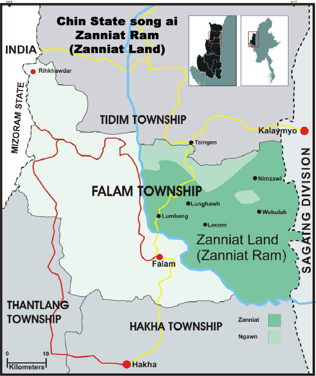
The Tashons people are ethnic tribes that live in the Falam Township, in the central part of Chin State, Myanmar. The Tashons were the most powerful tribes in the north of the Chin Hills prior to the British Empire's annexation of the region. Their influence extended over the borders of Manipur in the north, Hualngo and Lusai Hills in the west, the Phau River in the south and the Kalay-Kabaw Valley and Zanniat land in the east. They practiced a democratic system where the position of Chief was attained not by the virtue of birth but by vote of the people. The Tashons tribe and their villages were ruled by the Fahlam Council or Tashon Democratic Council, locally known as Nam Kap. The Tashons people have their own language, customs and culture.
Torbung is a census village split across the Bishnupur district and Churachandpur district in Manipur, India. The Bishnupur part of the village has a population of 2781, and the Churachandpur part a population of 1047 in the 2011 census. Torbung is on the bank of the Torbung river, which flows down from Thangjing hills to join the Khuga River. It is a village of historical as well as current political significance.
References
- ↑ Burma Census 1931 Burma Library website.
- ↑ The Chin Hills: a history of the people, our dealings with them, their customs and manners, and a gazetteer of their country Vol-1
- ↑ Stevenson, H. N. C.; Digital Library Of India (1943-01-01). The Economics Of The Central Chin Tribes. The Times Of India Press.
- ↑ Stevenson, H. N. C.; Digital Library Of India (1943-01-01). The Economics Of The Central Chin Tribes. The Times Of India Press.
- ↑ Zanniat Land Zanniat website 2011.
- ↑ "1st Chin Rifles". The Burma Campaign. Retrieved 2 March 2023.
- ↑ La Polla R. J. and Thurgood G. Sino-Tibetan Languages Routledge, 2016 ISBN 1315399482.
- ↑ "Chin, Falam" Ethnologue, languages of the world website. Accessed 6 July 2017.]
- 1 2 Cary, B. S.; Tuck, H. N. (1896). The Chin Hills, Vol.1. The superintendent, Government Printing, Burma. p. 146.
- ↑ Scott J. C.The Art of not being Governed Yale University Press, 2009 p212. ISBN 0300156529.
- ↑ Persecution of Chin Christians in Burma Chin Human Rights Organisation website.
- ↑ Hre Kio S. A Short History of Christianity in Burma Mount Pleasant Christian Church documents.
| Kachin (12) | |
|---|---|
| Kayah (9) | |
| Kayin (Karen) (11) | |
| Chin (53) |
|
| Bamar (Burman) (9) | |
| Mon (1) | |
| Rakhine (Arakanese) (7) | |
| Shan (33) | |
| Unrecognised / Others | |