An earthquake affected several villages in the Kerman province of Iran on February 22, 2005, at . The shock measured 6.4 on the moment magnitude scale and had a maximum Mercalli intensity of VIII (Severe). Zarand is located 740 km southeast of Tehran. The maximum recorded peak ground acceleration was 0.51 g at Shirinrud dam. The United States' National Earthquake Information Center and the Belgian' Centre for Research on the Epidemiology of Disasters both show that 612 died and 1,411 were injured in the event.

Borujerd is a city in the Central District of Borujerd County, Lorestan province in western Iran, serving as capital of both the county and the district.

The Jāmeh Mosque of Borujerd is a congregational mosque (Jāmeh) in Borujerd, in the province of Loristan, western Iran. The mosque is the oldest mosque in the Zagros area and western Iran. It ranks as No. 228 in the Inventory of National Artefacts of Iran.

The 1990 Manjil–Rudbar earthquake occurred on Thursday, 21 June 1990 at in the Caspian Sea region of northern Iran. The shock had a moment magnitude of 7.4 and a Mercalli Intensity of X (Extreme). Devastation occurred in a 20,000 km2 (7,700 sq mi) area, causing extensive damage in several cities. A large aftershock also added to the destruction. Between 35,000 and 50,000 people died in the earthquake; another 60,000–105,000 were injured.
The February 1998 Afghanistan earthquake occurred at near the Afghanistan-Tajikistan border. The strike-slip shock had a moment magnitude of 5.9 and a maximum Mercalli intensity of VII. With several thousand dead and hundreds injured, the event's effects were considered extreme by the National Geophysical Data Center. It was felt at Tashkent and Dushanbe, and aftershocks continued for the next seven days.
An earthquake occurred in northern Afghanistan on 30 May 1998, at 06:22 UTC in Takhar Province, with a moment magnitude of 6.5 and a maximum modified Mercalli intensity of VII. At the time, the Afghan Civil War was underway; the affected area was controlled by the United Islamic Front for the Salvation of Afghanistan.

The 2004 Al Hoceima earthquake occurred on 24 February at 02:27:47 local time near the coast of northern Morocco. The strike-slip earthquake measured 6.3 on the moment magnitude scale and had a maximum perceived intensity of IX (Violent) on the Mercalli intensity scale. Between 628 and 631 people were killed, 926 injured, and up to 15,000 people were rendered homeless in the Al Hoceima-Imzourene-Beni Abdallah area.
The 1909 Borujerd earthquake also known as Silakhor earthquake occurred in Silakhor plain, Persia on January 23. Around 8,000 fatalities were caused directly from the magnitude 7.3 earthquake. An indefinite number of aftershocks continued for six months after the main shock. The section on this fault ruptured was the same as the main rupture zone of the 2006 Borujerd earthquake.
The 1930 Salmas earthquake occurred on in West Azerbaijan Province, Iran. The earthquake, which was among Iran's largest, measured 7.1 on the moment magnitude scale and had a maximum Mercalli intensity of IX (Violent). A damaging foreshock occurred fifteen hours prior to the main event and served as a warning to the people that felt it strongly. Reports from seismologists and seismological organizations indicate that up to 3,000 fatalities may have occurred in northwest Iran and southeast Turkey.
The 1988 Nepal earthquake occurred in Nepal near the Indian border and affected much of northern Bihar. The magnitude 6.9 earthquake shook the region on August 21, killing at least 709 persons and injuring thousands. The earthquake struck in two installments of 10 seconds and 15 seconds each and left cracks in 50,000 buildings, including Raj Bhavan and the old Secretariat Building in Patna, Bihar.
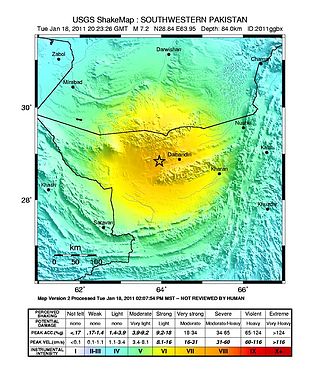
The 2011 Dalbandin earthquake occurred on with a moment magnitude of 7.2 and a maximum Mercalli intensity of VII. The shock occurred in a sparsely populated area of Balochistan, caused moderate damage, three deaths, and some injuries.
Darb-e Astaneh Khalid Ebn Ali is a village in Shirvan Rural District, in the Central District of Borujerd County, Lorestan Province, Iran. At the 2006 census, its population was 603, in 148 families.
The 2004 Nabire earthquake occurred on November 26 in Nabire Regency, Central Papua, Indonesia. The strike-slip event had a moment magnitude of 7.1 and a maximum Mercalli intensity of VIII (Severe). Total deaths for the event amounted to 32, and the total number of injured was 130–213.

The 1918 San Jacinto earthquake occurred in extreme eastern San Diego County in Southern California on April 21 at . The shock had a moment magnitude of 6.7 and a maximum Mercalli intensity of IX (Violent). Several injuries and one death occurred with total losses estimated to be $200,000.
The 1981 Golbaf earthquake occurred on June 11 at with a moment magnitude of 6.6 and a maximum Mercalli intensity of VIII+ (Severe). Total damage was considered moderate and amounted to $5 million in financial losses, with many injured, and 1,400–3,000 killed.
The 2004 Baladeh earthquake occurred on May 28 in northern Iran. This dip-slip earthquake had a moment magnitude of 6.3 and a maximum Mercalli intensity of VIII (Severe). Total deaths for the event amounted to 35, with 278–400 injured, and $15.4 million in damage.

The 1995 Kerinci earthquake struck near Sungai Penuh in Jambi Province on the island of Sumatra, Indonesia. It earthquake occurred at 01:18 WIB local time on October 7. The earthquake measured 6.7 on the moment magnitude scale, and 6.9–7.0 on the surface wave magnitude scale. Between 84 and possibly even 100 people were killed in the earthquake. An extimated 4,000 buildings collapsed or were seriously damaged while a further 5,000 suffered some damage.
The 1998 Zhangbei–Shangyi earthquake occurred at 11:50 local time on 10 January with a moment magnitude of 5.7 at a depth of 14.1 km. It struck the province of Hebei in Zhangjiakou. At least 70 people died, 11,500 were injured and a further 44,000 families were homeless in the wake of the event. Damage was reported in the town of Zhangbei, Hebei Province, as well as to sections of the Great Wall of China.
On 29 November, at 14:10 UTC, a magnitude 7.7 earthquake struck off the southern coast of Taliabu Island Regency in North Maluku, Indonesia. At least 41 people were killed on the nearby islands and a tsunami was triggered. Several hundred homes, buildings and offices were damaged or destroyed.
The 1957 Sangchal earthquake struck northern Iran's Mazandaran province on 2 July 1957. It had a moment magnitude of 6.6 or 7.1 (Mw ), focal depth of 15 km (9.3 mi), and maximum Modified Mercalli intensity of IX (Violent). It devastated many communities in the Alborz Mountains and caused an estimated 1,500 fatalities. Damage was estimated at US$25 million.

