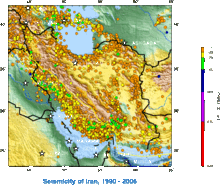

Iran is one of the most seismically active countries in the world, being crossed by several major faults that cover at least 90% of the country. [1] As a result, earthquakes in Iran occur often and are destructive.
Iran is one of the most seismically active countries in the world, being crossed by several major faults that cover at least 90% of the country. [1] As a result, earthquakes in Iran occur often and are destructive.
The Iranian plateau is subject to most types of tectonic activity, including active folding, faulting and volcanic eruptions. It is well known for its long history of disastrous earthquake activity. Not only have these earthquakes killed thousands, but they have also led to waste of valuable natural resources. [2] Since 1900, at least 126,000 fatalities have resulted from earthquakes in Iran. [2] In addition, the Iranian Plate is bordered by the Indian Plate (to the southeast), the Eurasian Plate (to the north), and the Arabian Plate (to the south and west), which is where the Zagros fold and thrust belt (an ancient subduction zone) lies.
| Date | Province | Mag. | MMI | Deaths | Injuries | Total damage/notes | Citations |
|---|---|---|---|---|---|---|---|
| 2023-10-17 | Hormozgan | 5.5 Mw | [3] | ||||
| 2023-01-28 | West Azerbaijan | 5.9 Mw | VII | 3 | 1,750 | Widespread damage | [4] |
| 2023-01-18 | West Azerbaijan | 5.7 Mw | VII | 252 | Severe damage | [5] | |
| 2022-10-05 | West Azerbaijan | 5.6 Mw | VII | 1,127 | Severe damage | [6] | |
| 2022-07-23 | Hormozgan | 5.6 Mw | VII | 1 | Further damage | [7] [8] | |
| 2022-07-03 | Gilan | 4.3 Mw | 1 | Minor damage | [9] [10] | ||
| 2022-07-01 | Hormozgan | 6.0 Mw | VII | 7 | 111 | Severe damage/doublet | [11] [12] |
| 2022-06-25 | Hormozgan | 5.6 Mw | VII | 1 | 37 | [13] | |
| 2022-04-23 | Fars | 4.4 Mw | VI | 1 | Minor damage | [14] [15] | |
| 2022-03-20 | Fars | 4.7 Mw | VII | 2 | Minor damage | [16] [17] | |
| 2022-03-16 | Hormozgan | 5.9 Mw | VII | 2 | Minor damage | [18] [19] | |
| 2022-01-23 | East Azerbaijan | 4.0 Mw | VII | 1 | Minor damage | [20] | |
| 2021-11-14 | Hormozgan | 6.4 Mw | IX | 2 | 98 | Doublet | [21] [22] |
| 2020-05-07 | Tehran | 4.6 Mw | V | 2 | 38 | [23] [24] | |
| 2020-02-23 | West Azerbaijan | 5.7 Mw | VII | 10 | 125 | [25] | |
| 2019-11-07 | East Azerbaijan | 5.9 Mw | VIII | 7 | 584 | [26] | |
| 2019-07-08 | Khuzestan | 5.7 Mw | VII | 1 | 100 | [27] | |
| 2018-11-25 | Kermanshah | 6.3 Mw | VIII | 1 | 761 | Aftershock | |
| 2018-08-25 | Kermanshah | 6.0 Mw | VII | 3 | 243 | Aftershock | |
| 2017-12-20 | Tehran | 5.2 Mw | VI | 2 | 97 | 4.0 Mw aftershock: 1 dead, 75 injured | |
| 2017-11-12 | Kermanshah | 7.3 Mw | VIII | 630 | 8,435 | ||
| 2017-05-13 | North Khorasan | 5.6 Mw | VII | 3 | 370 | ||
| 2017-04-05 | Khorasan-e Razavi | 6.1 Mw | VII | 2 | 34 | ||
| 2017-01-06 | Fars | 5.0 Mw | VI | 4 | 5 | ||
| 2014-08-18 | Ilam | 6.2 Mw | VIII | 60–330 | |||
| 2013-11-28 | Bushehr | 5.6 Mw | VII | 7 | 45 | ||
| 2013-04-13 | Sistan and Baluchestan | 7.7 Mw | VIII | 35 | 117 | ||
| 2013-04-09 | Bushehr | 6.3 Mw | 37 | 850 | |||
| 2012-08-11 | East Azerbaijan | 6.4 Mw | VIII | 306 | 3,037 | Doublet | |
| 2012-08-11 | East Azerbaijan | 6.3 Mw | Doublet | ||||
| 2011-06-15 | Kerman | 5.3 | 2 | ||||
| 2010-12-20 | Kerman | 6.5 Mw | IX | 11 | 100 | ||
| 2010-08-27 | Semnan | 5.8 Mw | VII | 4 | 40 | 800 displaced | |
| 2010-07-30 | Razavi Khorasan | 5.5 Mw | VI | 274 | Severe damage | ||
| 2008-09-10 | Qeshm | 5.9 Mw | 7 | 45 | |||
| 2006-03-31 | Lorestan | 6.1 Mw | VIII | 63–70+ | 1,246–1,418 | ||
| 2005-11-27 | Qeshm | 5.8 Mw | VII | 13 | 100 | ||
| 2005-02-22 | Kerman | 6.4 Mw | VIII | 612 | 1,411 | ||
| 2004-05-28 | Māzandarān | 6.3 Mw | VIII | 35 | 278–400 | $15.4 million | |
| 2003-12-26 | Kerman | 6.6 Mw | IX | 26,271 | 22,628–30,000 | 45,000–75,600 displaced | |
| 2002-06-22 | Qazvin | 6.3 Mw | VIII | 261 | 1,500 | ||
| 1999-03-04 | Kerman | 6.6 Mw | VII | 1 | 517 houses damaged | [28] | |
| 1998-03-14 | Kerman | 6.6 Mw | VIII | 5 | 50 | [29] | |
| 1997-05-10 | South Khorasan | 7.3 Mw | X | 1,567 | 2,300 | ||
| 1997-02-28 | Ardabil | 6.1 Mw | VIII | 1,100 | 2,600 | ||
| 1997-02-04 | North Khorasan | 6.5 Mw | VIII | 100 | 1,948 | ||
| 1990-06-20 | Gilan | 7.4 Mw | X | 35,000–50,000 | 60,000–105,000 | ||
| 1981-07-28 | Kerman | 7.1 Ms | IX | 1,500 | 1,000 | ||
| 1981-06-11 | Kerman | 6.6 Mw | VIII+ | 1,400–3,000 | many | ||
| 1979-11-14 | South Khorasan | 6.8 Mw | VIII | 297–440 | |||
| 1978-09-16 | South Khorasan | 7.4 Mw | IX | 15,000–25,000 | |||
| 1977-12-19 | Kerman | 5.9 Mw | VII | 584–665 | |||
| 1977-04-06 | Chaharmahal and Bakhtiari | 6.0 Mw | VIII | 348–366 | |||
| 1977-03-21 | Hormozgan | 7.0 Ms | VIII | 152–167 | |||
| 1972-04-10 | Fars | 6.7 Mw | IX | 5,374 | 1,710 | ||
| 1970-07-30 | Khorasan | 6.4 | 175 | 450 | [30] [31] | ||
| 1968-08-31 | South Khorasan | 7.4 Mw | X | 15,000 | |||
| 1968-09-01 | South Khorasan | 6.4 Mw | 900 | ||||
| 1965-02-10 | East Azerbaijan | 5.1 | 20 | ||||
| 1962-09-01 | Qazvin | 7.1 ML | IX | 12,225 | 2,776 | ||
| 1960-04-24 | Fars | 6.0 Muk | 420 | [32] | |||
| 1958-08-16 | Hamadan | 6.7 Muk | 132 | [32] | |||
| 1957-12-13 | Kermanshah | 7.1 | 1,130 | ||||
| 1957-07-02 | Māzandarān | 7.1 | 1,200 | ||||
| 1953-02-12 | Semnan | 6.6 Mw | VIII | 800–973 | 140 | ||
| 1947-08-05 | South Khorasan | 7.3 | 500 | ||||
| 1932-05-20 | Māzandarān | 5.4 Muk | VIII | 1,070 | [32] | ||
| 1930-05-07 | West Azerbaijan | 7.1 Mw | IX | 1,360–3,000 | |||
| 1929-05-01 | Khorasan-e Razavi | 7.2 Mw | IX | 3,257–3,800 | 1,121 | ||
| 1923-05-25 | Khorasan-e Razavi | 5.9 Mw | VII+ | 2,200 | More than 7 villages destroyed | [33] | |
| 1909-01-23 | Lorestan | 7.3 ML | IX | 6,000–8,000 | |||
| 1895-01-17 | Khorasan-e Razavi | 6.8 Ms | VIII | 1,000–11,000 | |||
| 1893-11-17 | Khorasan-e Razavi | 6.6 Ms | X | 18,000 | [34] | ||
| 1864-01-17 | Kerman | VIII | Many | [32] | |||
| 1853-05-05 | Fars | IX | 9,000–13,000 | [32] | |||
| 1778-12-15 | Kashan | 6.2 Ms | >8,000 | [34] | |||
| 1755-06-07 | Isfahan | 40,000 | |||||
| 1727-11-18 | East Azerbaijan | VIII | 77,000 | ||||
| 1721-04-26 | East Azerbaijan | 7.7 Ms | VIII–X | 8,000–250,000 | |||
| 1679-06-04 | Yerevan, Armenia | 6.4 Ms | IX–X | 7,600 | Under Iranian rule at the time | ||
| 1667-11-25 | Shamakhi, Azerbaijan | 6.9 Ms | X | 80,000 | Under Iranian rule at the time | ||
| 1641-02-05 | Tabriz, East Azerbaijan | 6.8 Ms | IX | 30,000 | Tabriz completely destroyed | ||
| 1101-??-?? | Khorasan-e Razavi | 6.5 Muk | X | 60,000 | [35] | ||
| 1042-08-21 | East Azerbaijan | 7.6 | 40,000 | ||||
| 1008-04-11 | Bushehr | 6.5 Ms | 16,000 | [35] | |||
| 978-06-17 | Bushehr | 5.3 Ms | 2,000 | [35] | |||
| 893-03-23 | Ardabil | 150,000 | See also 893 Dvin earthquake | ||||
| 856-12-22 | Semnan | 7.9 Ms | X | 200,000 | |||
| 850-07-15 | Tehran | 45,000 | [35] | ||||
| 743-??-?? | Semnan | 7.2 Ms | IX | [35] | |||
| 662-04-26 | Semnan | 40,000 | [35] | ||||
| 400? BCE | Tehran | 7.6 | [35] | ||||
| Note: Mw = moment magnitude scale, Ms = surface wave magnitude, and Muk = unknown. The inclusion criteria for adding events are based on WikiProject Earthquakes' notability guideline that was developed for stand alone articles. The principles described also apply to lists. In summary, only damaging, injurious, or deadly events should be recorded. | |||||||

Earthquakes are caused by movements within the Earth's crust and uppermost mantle. They range from events too weak to be detectable except by sensitive instrumentation, to sudden and violent events lasting many minutes which have caused some of the greatest disasters in human history. Below, earthquakes are listed by period, region or country, year, magnitude, cost, fatalities and number of scientific studies.

On 12 November 2017 at 18:18 UTC, an earthquake with a moment magnitude of 7.3 occurred on the Iran–Iraq border, with the Iraqi Kurdish city of Halabja, and the Kurdish dominated places of Ezgeleh, Salas-e Babajani County, Kermanshah Province in Iran, closest to the epicentre, 30 kilometres (19 mi) south of the city of Halabja, Iraqi Kurdistan.
The 1979 Ghaenat earthquakes were a series of large earthquakes in Qaen County, Khorasan Province, northeast Iran, near the Afghanistan border. The first mainshock, known as the Korizan earthquake with a surface wave magnitude (Ms ) of 6.6 and moment magnitude (Mw ) of 6.8, struck on November 14, while the Ms 7.1 or Mw 7.2 Koli-Boniabad earthquake struck on November 27. The two mainshocks were assigned a maximum Modified Mercalli intensity of VIII (Severe) and X (Extreme), respectively. The earthquakes caused extensive damage throughout northeastern Iran, killing an estimated 297 to 440 people and left at least 279 injured.

The 2021 Hormozgan earthquakes was a doublet earthquake event in Iran that occurred on November 14, 2021 with magnitudes of 6.0 and 6.4 on the moment magnitude scale. The two quakes occurred just a minute and a half apart, killing 2 people and injuring a further 100.
The 2022 Hormozgan earthquakes were a pair of doublet earthquakes that struck southern Iran on 1 July, 2022. The earthquakes, which occurred around two hours apart, killed seven people and injured dozens more.
Starting on 21 September 2022, and progressing into 2023, an earthquake swarm occurred in the Iranian province of West Azerbaijan, close to the city of Khoy near the Turkish border. Due to mainly three events, a total of 3,880 buildings were destroyed and 52,301 others were damaged in Khoy, including nearly 1,000 schools. Three people died and over 3,310 others were injured, almost all of them due to panic and only a few from collapsed houses.
Sources
| Authority control databases: National |
|---|