Related Research Articles

A flood is an overflow of water that submerges land that is usually dry. In the sense of "flowing water", the word may also be applied to the inflow of the tide. Floods are an area of study of the discipline hydrology and are of significant concern in agriculture, civil engineering and public health. Human changes to the environment often increase the intensity and frequency of flooding, for example land use changes such as deforestation and removal of wetlands, changes in waterway course or flood controls such as with levees, and larger environmental issues such as climate change and sea level rise. In particular climate change's increased rainfall and extreme weather events increases the severity of other causes for flooding, resulting in more intense floods and increased flood risk.

Silt is granular material of a size between sand and clay and composed mostly of broken grains of quartz. Silt may occur as a soil or as sediment mixed in suspension with water. Silt usually has a floury feel when dry, and lacks plasticity when wet. Silt also can be felt by the tongue as granular when placed on the front teeth.

The Little Colorado River is a tributary of the Colorado River in the U.S. state of Arizona, providing the principal drainage from the Painted Desert region. Together with its major tributary, the Puerco River, it drains an area of about 26,500 square miles (69,000 km2) in eastern Arizona and western New Mexico. Although it stretches almost 340 miles (550 km), only the headwaters and the lowermost reaches flow year-round. Between St. Johns and Cameron, most of the river is a wide, braided wash, only containing water after heavy snowmelt or flash flooding.

The Glenmore Reservoir is a large reservoir on the Elbow River in the southwest quadrant of Calgary, Alberta. It is controlled by the Glenmore Dam, a concrete gravity dam on the Elbow River. The Glenmore Reservoir is a primary source of drinking water to the city of Calgary. Built in 1932, with a cost of $3.8 million, the dam controls the downstream flow of the Elbow River, thus allowing the city to develop property near the river's banks with less risk of flooding.

The MeenachilRiver or Meenachilaar, also known as Kavanar, Valanjar, is a river in Kerala. It is one of the most treacherous rivers in Kerala due to its flash floods, heavy undercurrents and woods and debris it carries from the mountains. It flows through the heart of Kottayam district, Kerala state in southern India. 78km long, originates in the Western Ghats main tributaries are Theekoy aaru from Vagamon hills, Poonjar Aaru and Chittar, flowing westward through the city of Kottayam and other towns like Poonjar, Teekoy, Aruvithura, Bharananganam, Pala, Mutholy, Cherpunkal, Kidangoor and Kumarakom before emptying into the Vembanad Lake on the shore of the Indian Ocean.

A mudflow, also known as mudslide or mud flow, is a form of mass wasting involving fast-moving flow of debris and dirt that has become liquified by the addition of water. Such flows can move at speeds ranging from 3 meters/minute to 5 meters/second. Mudflows contain a significant proportion of clay, which makes them more fluid than debris flows, allowing them to travel farther and across lower slope angles. Both types of flow are generally mixtures of particles with a wide range of sizes, which typically become sorted by size upon deposition.
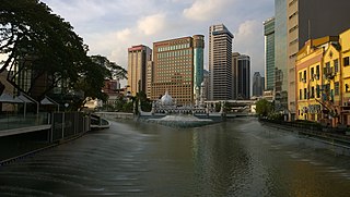
The Klang River is a river which flows through Kuala Lumpur and Selangor in Malaysia and eventually flows into the Straits of Malacca. It is approximately 120 km (75 mi) in length and drains a basin of about 1,288 km2 (497 sq mi). The Klang River has 11 major tributaries.

A beaver dam or beaver impoundment is a dam built by beavers to create a pond which protects against predators such as coyotes, wolves and bears, and holds their food during winter. These structures modify the natural environment in such a way that the overall ecosystem builds upon the change, making beavers a keystone species and ecosystem engineers. They build prolifically at night, carrying mud with their forepaws and timber between their teeth.

The Upper Wardha Dam is an earthfill straight gravity dam across the Wardha River, a tributary of the Godavari River, near Simbhora village in Morshi taluk in Amravati district in the Indian state of Maharashtra. The dam provides multipurpose benefits of irrigation, drinking water supply, flood control and hydropower generation.
The 2014 Cameron Highlands mud floods took place in Cameron Highland, Pahang, Malaysia on 5 and 6 November 2014. More than 20 houses in Ringlet town, Ringlet new village, Kampung Ulu Merah Ringlet and Bertam Valley were submerged in knee-deep flood waters. At least three people were killed while five others were injured, according to official reports. The electrical supply to the affected villages was cut off for several weeks. About 90 victims from 28 families were evacuated to a relief centre in Ringlet. This was the second time that mud floods of this magnitude had ravaged the Bertam Valley since the 2013 mud floods. The mud floods had been largely attributed to illegal land clearing by foreign illegal immigrants who were involved in the rapidly expanding agricultural industry there. Pahang Sultan Ahmad Shah has orders to stop the illegal farming and there is a claim of corruption involving the illegal land clearing.
The Ulu Jelai Power Station is a hydroelectric power station located in the district of Cameron Highlands, Pahang, Malaysia. It is one of the entry point projects under the Economic Transformation Programme.

Tengku Maimun binti Tuan Mat is a Malaysian lawyer who has served as the 10th Chief Justice of Malaysia since May 2019. She is the first woman to ascend to the highest judicial office of the country.

Giba is a river of northern Ethiopia. It starts at the confluence of Genfel and Sulluh and flows westward to the Tekezé River. Future Lake Giba will occupy the plain where Sulluh, Genfel and Agula'i Rivers meet, and hence be the future source of Giba River.

May Be’ati is a river of the Nile basin. Rising in the mountains of Dogu’a Tembien in northern Ethiopia, it flows southward to empty finally in Giba and Tekezé River.

Ilala is a river of northern Ethiopia. Rising in the mountains of Dergajen, it flows westward to Giba River which empties finally in the Tekezé River.

Agula’i is a river of northern Ethiopia. Rising in the mountains of Atsbi Wenberta, it flows southwestward to Giba River which empties finally in the Tekezé River. Future Lake Giba will occupy the plain where Sulluh, Genfel and Agula’i Rivers meet.

Genfel is a river of northern Ethiopia. Rising on the foot of the Atsbi horst at 2253 metres above sea level, it flows southwestward to Giba River which empties finally in the Tekezé River. Future Lake Giba will occupy the plain where Sulluh, Genfel and Agula'i Rivers meet.
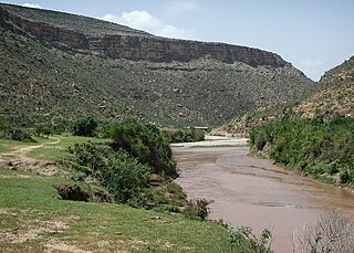
Sulluh is a river of northern Ethiopia. Rising in the mountains of Mugulat, it flows southward to Giba River which empties finally in the Tekezé River. Future Lake Giba will occupy the plain where Sulluh, Genfel and Agula'i Rivers meet.
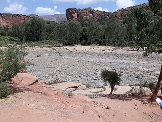
Tanqwa is a river of northern Ethiopia. Rising in the mountains of Dogu’a Tembien, it flows westward to Giba River which empties finally in the Tekezé River.
References
- 1 2 Manjit Kaur (23 October 2013). "Three killed in mud flood after water released from Cameron Highlands dam". The Star . Retrieved 24 October 2013.
- ↑ "Mud flood kills 3, one missing in Cameron Highlands". Thai PBS. 24 October 2013. Archived from the original on 20 September 2017. Retrieved 24 October 2013.
- 1 2 "80 houses swept away, 3 dead, 1 missing after dam gates opened in Cameron Highlands". The Malaysian Insider. 23 October 2013. Archived from the original on 25 October 2013. Retrieved 24 October 2013.
- ↑ "3 Dead After More Floods in Cameron Highlands, Malaysia - FloodList". FloodList. Retrieved 23 November 2015.
- ↑ Aminuddin, B. Y.; Ghulam, M. H.; Abdullah, W. Y. Wan; Zulkefli, M.; Salama, R. B. (1 August 2005). "Sustainability of Current Agricultural Practices in The Cameron Highlands, Malaysia". Water, Air, & Soil Pollution: Focus. 5 (1–2): 89–101. CiteSeerX 10.1.1.467.476 . doi:10.1007/s11267-005-7405-y. ISSN 1567-7230. S2CID 38829894.
- 1 2 3 "The River systems, the floods-Part 2 | CHEAM MAY CHOO". www.cheammaychoo.com. Archived from the original on 24 November 2015. Retrieved 23 November 2015.