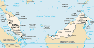
The geography of Malaysia includes both the physical and the human geography of Malaysia, a Southeast Asian country made up of two major landmasses separated by water—Peninsular Malaysia to the West and East Malaysia to the East—and numerous smaller islands that surround those landmasses. Peninsular Malaysia is on the southernmost part of the Malay Peninsula, south of Thailand, north of Singapore and east of the Indonesian island of Sumatra; East Malaysia comprises most of the northern part of Borneo island, and shares land borders with Brunei to the north and Indonesian Borneo to the south.

Kedah, also known by its honorific Darul Aman and historically as Queda, is a state of Malaysia, located in the northwestern part of Peninsular Malaysia. The state covers a total area of over 9,000 km2, and it consists of the mainland and the Langkawi islands. The mainland has a relatively flat terrain, which is used to grow rice, while Langkawi is an archipelago, most of which are uninhabited islands.

Langkawi, officially known by its sobriquet Langkawi, the Jewel of Kedah, is a duty-free island and an archipelago of 99 islands located some 30 km off the coast of northwestern Malaysia and a few kilometres south of Ko Tarutao, adjacent to the Thai border. Politically, it is an administrative district of Kedah, with Kuah as its largest town. Pantai Cenang is the island's most popular beach and tourist area.

On 26 December 2004, at 07:58:53 local time (UTC+7), a major earthquake with a magnitude of 9.1–9.3 struck with an epicentre off the west coast of northern Sumatra, Indonesia. The undersea megathrust earthquake, known by the scientific community as the Sumatra–Andaman earthquake, was caused by a rupture along the fault between the Burma Plate and the Indian Plate, and reached a Mercalli intensity up to IX in some areas.

According to official estimates in India, 10,749 people were killed, 5,640 people were missing and thousands of people became homeless when a tsunami triggered by the 2004 Indian Ocean earthquake near the Indonesian island of Sumatra struck the southern coast on 26 December 2004. The earthquake registered 9.1–9.3 Mw and was the largest in five decades. It was followed by strong aftershocks on the Andaman and Nicobar Islands. The death toll of the earthquake was 1,500 people.
The 2004 Indian Ocean earthquake and tsunami occurred on Sunday, December 26, 2004. The earthquake itself, with a moment magnitude of around 9.1-9.3, devastated Aceh Province, Indonesia, while the tsunami affected countries all around the Indian Ocean. Nations which were affected are listed below in alphabetical order. For detailed information about each country affected by the earthquake and tsunami, see their individual articles. Countries with a smaller number of casualties, as well as those that lost citizens who were travelling abroad, are listed further on in the article.

Indonesia was the first country to be seriously affected by the earthquake and tsunami created by the 2004 Indian Ocean earthquake on 26 December 2004, swamping the northern and western coastal areas of Sumatra, and the smaller outlying islands off Sumatra. Nearly all the casualties and damage took place within the province of Aceh. The time of arrival of the tsunami was between 15 and 30 minutes after the deadly earthquake. According to the country's National Disaster Relief Coordination Agency, around 130,000 people were dead and 37,063 were missing. In addition, the UN estimated that 655,000 people were homeless and sheltering in scattered refugee camps across the province.
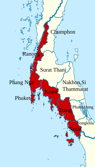
Thailand was one of the 14 countries affected by the 2004 Indian Ocean earthquake and tsunami on 26 December 2004. It left behind unprecedented damage and destruction in six provinces of Thailand, impacting 407 villages, completely destroying 47 of them, including prominent tourist resorts like Khao Lak. The disaster killed about 5,400 people in Thailand, including foreign tourists.

The 2005 Nias–Simeulue earthquake occurred on 28 March off the west coast of northern Sumatra, Indonesia. At least 915 people were killed, mostly on the island of Nias. The event caused panic in the region, which had already been devastated by the massive tsunami triggered by the 2004 Indian Ocean earthquake, but this earthquake generated a relatively small tsunami that caused limited damage. It was the third most powerful earthquake since 1965 in Indonesia.

Batu Ferringhi is a suburb of George Town in the Malaysian state of Penang. Located along the northern coast of Penang Island and about 11 km (6.8 mi) northwest of the city centre, it is the prime beach destination in Penang among locals and tourists. To cater to the influx of tourists, several major high-rise hotels have been established along the 4 km (2.5 mi) stretch of beaches.

Mount Jerai, formerly Kedah Peak, is a mountain in Kedah, Malaysia with the height of 3,993 feet (1,217 m). Within Kedah itself, the mountain stands at the border of Kuala Muda and Yan districts.

Kuala Kedah is a mukim and parliamentary constituency in Kota Setar District, Kedah, Malaysia. It is a fishing port, located at the mouth of the Kedah River, and serves as a terminus for ferries to the tourist island of Langkawi. It is home to a fort, Kota Kuala Kedah. Kuala Kedah is accessible by bus or taxi from Alor Setar.

The Kuala Muda District is a district in Kedah, Malaysia. Sungai Petani is the administrative center of the district. Kuala Muda district is in close proximity to the border of Kedah and Penang. Apart from Sungai Petani, other major towns in the district include Tikam Batu, Padang Tembusu, Sungai Lalang, Bedong, Bukit Selambau, Sidam, Gurun, Semeling, Merbok, Kota Kuala Muda and Tanjung Dawai. The Mount Jerai is shared with the neighbouring district of Yan while the Muda River is shares the bordering state of Penang. The iconic Jambatan Merdeka connect both Tikam Batu with Bumbung Lima in Penang. Kuala Muda is the second largest and most populous district in Kedah, and it is also the site of some of the earliest civilization site in the country.

The September 2007 Sumatra earthquakes were a series of megathrust earthquakes that struck the Sunda Trench off the coast of Sumatra, Indonesia, with three of magnitude 7 or greater. A series of tsunami bulletins was issued for the area. The most powerful of the series had a magnitude of 8.5, which makes it in the top 20 of the largest earthquakes ever recorded on a seismograph.
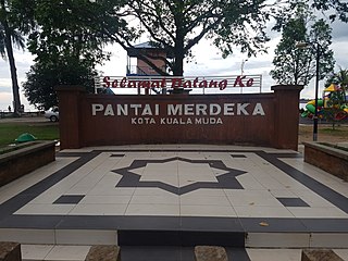
Pantai Merdeka is a coastal location in Kuala Muda District, Kedah, Malaysia. It has the only sand beach in mainland Kedah, and it is the major attraction for beach goers from all over northern Penang and Kedah State. Various accommodation is available for rent to experience the beach and other attractions in the area which includes harvesting Kepah, Siput Kemudi and Kerang in Kampung Tepi Sungai, Kota Kuala Muda, Pantai Merdeka itself and also at Pulau Sayak.

The Marine Police Force, Royal Malaysia Police is the Marine Police division of the Royal Malaysia Police tasked with maintaining law and order and execute national security operations in the Malaysian Territorial Waters (MTW) and no boundaries till the high seas. The Marine Police Force serves under the control of the Malaysian Internal Security & Public Order (ISPO) Department with the role of safeguarding the security of Malaysian waters from any threats.

The Northern Corridor Economic Region is a development plan encompassing the four northwestern states of Malaysia, namely Perlis, Penang, Kedah and Perak. It was launched in 2007 by the federal government with an aim to transform the region into a sustainable and socio-economically balanced region by 2025. The Northern Corridor Implementation Authority (NCIA) is the statutory body responsible to establishing the NCER's direction, policies and strategies.

The following lists events from 2015 in Malaysia.

A Mw 6.4 earthquake struck the island of Lombok on the morning of 29 July 2018 at a shallow depth of 14 km (8.7 mi). Widespread damage was reported in the area, and authorities confirmed that 20 people were killed in the earthquake while hundreds were injured.

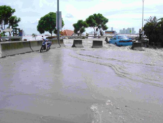
On 16 December 2021, a tropical depression made landfall on the eastern coast of Peninsular Malaysia, bringing torrential downpours throughout the peninsula for three days. The resulting floods affected eight states across the peninsula, and left at least 54 dead and 2 missing. During its furthest extent, it caused the concurrent displacement of more than 71,000 residents, and have affected over 125,000 people overall.