
Humphreys County is a county located in the western part of Middle Tennessee, in the U.S. state of Tennessee. As of the 2020 census, the population was 18,990. Its county seat is Waverly.
Waverly is a city in and the county seat of Humphreys County, Tennessee, United States. The population was 4,297 at the 2020 census.

Hurricane Opal was a large and powerful Category 4 hurricane that caused severe and extensive damage along the northern Gulf Coast of the United States in October 1995. The fifteenth named storm, ninth hurricane and strongest tropical cyclone of the unusually active 1995 Atlantic hurricane season, Opal developed from the interaction of a tropical wave and a low-pressure area near the Yucatán Peninsula on September 27 as Tropical Depression Seventeen. The depression crossed the Yucatán Peninsula and intensified into a tropical storm on September 30. Opal intensified into a hurricane on October 2 after entering the Gulf of Mexico. The cyclone turned northeastward and strengthened significantly. By October 4, Opal was an intense 150 mph (240 km/h), Category 4 hurricane. With a minimum pressure of 916 mbar (hPa), Hurricane Opal was the most intense category 4 Atlantic hurricane on record. However, the cyclone abruptly weakened to a low-end Category 3 hurricane prior to making landfall on the Florida Panhandle near Pensacola later that day. The storm quickly unraveled as it moved inland and became extratropical on October 5. The remnants of Opal moved northward and dissipated over Ontario the following day.

In October 2005, remnants of Tropical Storm Tammy and Subtropical Depression Twenty-Two merged with incoming continental cold fronts to produce torrential rains over interior New England, as well as over parts of New Jersey and New York. Particularly hard hit was the state of New Hampshire, which saw roads and bridges wiped out, several reported deaths, and whole buildings destroyed. Rain lingered over some areas for several weeks. Rainfall from both rain events totaled well over 20 inches (510 mm) in some areas.

Tropical Storm Claudette was a 1979 tropical cyclone which was the third-wettest tropical cyclone on record in the contiguous United States. The storm caused significant flooding in eastern Texas and western Louisiana in July 1979. The eighth tropical cyclone and third named storm of the 1979 Atlantic hurricane season, Claudette developed from a tropical wave located east of the Windward Islands on July 16. It gradually strengthened and was upgraded to a tropical storm on July 17 and crossed the northern Leeward Islands later that day. As it neared landfall in Puerto Rico early on July 18, upper-level winds weakened it back to a tropical depression. Claudette remained disorganized and the National Hurricane Center operationally reported that it degenerated back into a tropical wave after crossing Puerto Rico. Late on July 18, the depression struck Dominican Republic, emerged into the Caribbean Sea on the following day. Claudette struck western Cuba on July 21, shortly before reaching the Gulf of Mexico and "regenerating" into a tropical cyclone. By July 23, Claudette regained tropical storm intensity and turned northward toward the Gulf Coast of the United States. The storm made landfall near the Texas-Louisiana border late on July 23 as a moderately strong tropical storm. It weakened slowly and drifted over land, lasting until dissipation in West Virginia on July 29.

Tropical Storm Bill was a tropical storm that affected the Gulf Coast of the United States in the summer of 2003. The second storm of the 2003 Atlantic hurricane season, Bill developed from a tropical wave on June 29 to the north of the Yucatán Peninsula. It slowly organized as it moved northward, and reached a peak of 60 miles per hour (97 km/h) shortly before making landfall in south-central Louisiana. Bill quickly weakened over land, and as it accelerated to the northeast, moisture from the storm, combined with cold air from an approaching cold front, produced an outbreak of 34 tornadoes. Bill became extratropical on July 2, and was absorbed by the cold front later that day.

Tropical Storm Henri was a moderate tropical storm that formed in the 2003 Atlantic hurricane season. The eighth storm of the season, Henri was one of six tropical cyclones to hit the United States in the year. Henri formed from a tropical wave in the Gulf of Mexico in early September, and crossed over Florida as a tropical depression. Its remnants later moved into the Mid-Atlantic before dissipating completely.
Floods in the United States are generally caused by excessive rainfall, excessive snowmelt, and dam failure. Below is a list of flood events that were of significant impact to the country during the 20th century, from 1900 through 1999, inclusive.

Tropical Storm Doria was the costliest tropical cyclone in the 1971 Atlantic hurricane season. The fifth tropical storm of the season, Doria developed from a tropical wave on August 20 to the east of the Lesser Antilles, and after five days without development it attained tropical storm status to the east of Florida. Doria turned to the north, and reached peak winds of 65 mph (105 km/h) as it was making landfall near Morehead City, North Carolina. It turned to the northeast, and moved through the Mid-Atlantic and New England as a tropical storm before becoming an extratropical storm over Maine on August 29.
Floods in the United States (2000–present) is a list of flood events which were of significant impact to the country during the 21st century, since 2000. Floods are generally caused by excessive rainfall, excessive snowmelt, storm surge from hurricanes, and dam failure.
The September 2009 Southeastern United States floods were a group of floods that affected several counties throughout northern Georgia, Tennessee, Alabama, Mississippi, and Arkansas. The worst flooding occurred across the Atlanta metropolitan area. Continuous rain, spawned by moisture pulled from the Gulf of Mexico, fell faster than the local watersheds could drain the runoff.

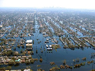
The 2010 Tennessee floods were floods in Middle Tennessee, West Tennessee, south-central and western Kentucky and northern Mississippi areas of the United States of America as the result of torrential rains on May 1 and 2, 2010. Floods from these rains affected the area for several days afterwards, resulting in a number of deaths and widespread property damage.

Tropical Storm Lee was the thirteenth named storm and fifteenth system overall of the 2011 Atlantic hurricane season, developing from a broad tropical disturbance over the gulf on September 1. It was designated as Tropical Storm Lee the next day. Prior to 2020, when Marco formed on August 22, Lee was tied with 2005's Maria as the earliest-forming 13th Atlantic tropical storm. The system was rather large, and due to drifting, Lee brought flash flooding to the Gulf Coast. Flooding associated with the rains caused significant property damage in the areas, with drowning deaths reported in both Mississippi and Georgia. Elsewhere, the storm helped spread wildfires that destroyed homes and killed two people in Texas, and a traffic accident in Alabama resulted in one death. Rough surf offshore drowned one person in each of these states. After becoming extratropical, Lee caused historic flooding in Pennsylvania, New York, and Canada, mainly Quebec and Ontario.
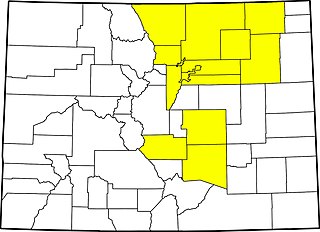
The 2013 Colorado floods were a series of natural disasters occurring in the U.S. state of Colorado. Starting on September 11, 2013, a slow-moving cold front stalled over Colorado, clashing with warm humid monsoonal air from the south. This resulted in heavy rain and catastrophic flooding along Colorado's Front Range from Colorado Springs north to Fort Collins. The situation intensified on September 11 and 12. Boulder County was worst hit, with 9.08 inches (231 mm) recorded September 12 and up to 17 inches (430 mm) of rain recorded by September 15, which is comparable to Boulder County's average annual precipitation. This event has also been referred to as the 2013 Colorado Front Range Flood, reflecting a more precise geographic extent in and along the Colorado Front Range mountains.
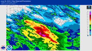
On June 23, 2016, a flood hit areas of the U.S. state of West Virginia and nearby parts of Virginia, resulting in 23 deaths. The flooding was the result of 8 to 10 inches of rain falling over a period of 12 hours, resulting in a flood that was among the deadliest in West Virginia history. It is also the deadliest flash flood event in the United States since the 2010 Tennessee floods.

In July 2019, parts of the Yorkshire Dales, in North Yorkshire, England, were subjected to above average rainfall for the time of year. The flash-flooding that followed affected many communities destroying bridges, sweeping roads away, causing landslips on railway lines and resulting in at least one public event being cancelled. The flooding even inundated the fire station in the town of Leyburn, in Wensleydale, whilst the crew were out helping those in need. The recovery took many weeks and months, with immediate help by the rescue services being bolstered by British Army personnel who assisted with the clean up.

A small but deadly tornado outbreak affected West and Middle Tennessee on the night of March 2 and into the morning of March 3, 2020, including a high-end EF3 tornado that hit Nashville and Mount Juliet, becoming the 6th costliest tornado in United States history, and a violent EF4 tornado that impacted areas in and just west of Cookeville. A total of 25 people were killed by the tornadoes, with an additional 309 being injured, and more than 70,000 lost electricity. The path of the Nashville tornado was very similar to the one that hit East Nashville in 1998. A few additional tornadoes were also confirmed in Alabama, southeastern Missouri, and western Kentucky. Total damage from the event reached $1.607 billion according to the National Centers for Environmental Information.

Tropical Storm Fay was the first tropical cyclone to make landfall in the U.S state of New Jersey since Hurricane Irene in 2011. The sixth named storm of the very active 2020 Atlantic hurricane season, Fay was the earliest sixth named storm on record in the basin when it formed on July 9. Fay originated from a surface low that formed over the Northern Gulf of Mexico on July 3 and slowly drifted eastward, before crossing over the Florida Panhandle. The system subsequently drifted across the Southeastern United States as a well-defined low pressure system, before emerging off the coast of North Carolina on July 8. From there, the storm utilized favorable conditions for development, or tropical cyclogenesis, and coalesced into a tropical storm on July 9. The storm intensified, reaching its peak intensity on July 10, with maximum 1-minute sustained winds of 60 mph (97 km/h) and a minimum central pressure of 998 millibars (29.5 inHg). While moving northward, Fay made landfall on New Jersey later that day. After making landfall, the storm quickly lost most of its organization and rapidly transitioned into a post-tropical cyclone over New York on July 11, before being absorbed by a larger extratropical low over Quebec on July 12.

Beginning on July 24, 2022, and lasting for a week, many flash flooding events hit several areas of the United States. These areas included parts of Missouri and Illinois, especially Greater St. Louis, Eastern Kentucky, Southwest Virginia, parts of West Virginia, and the Las Vegas Valley. Several rounds of severe thunderstorms began in Missouri on July 24, culminating during July 25 and 26, when St. Louis broke its previous 1915 record for the most rainfall in a span of 24 hours. Governor Mike Parson declared a state of emergency on July 26. Over one hundred people were rescued from floods, and two people were killed. Late on July 27 and into July 28, historic flooding began in central Appalachia, particularly in Kentucky, where a state of emergency was declared. A total of 38 people were killed in Kentucky as a direct result of flooding, with a 39th fatality occurring days later during cleanup efforts and a 40th coming in September during cleanup efforts in Pike County.


