Calloway County, Kentucky

Last updated

Calloway County
Courtsquarechouse.jpg
Calloway County courthouse in Murray
Flag of Calloway County, Kentucky.png
Seal of Calloway County, Kentucky.png
Map of Kentucky highlighting Calloway County.svg
Location within the U.S. state of Kentucky
Kentucky in United States.svg
Kentucky's location within the U.S.
Coordinates: 36°37′N88°16′W / 36.62°N 88.27°W / 36.62; -88.27
CountryFlag of the United States.svg United States
StateFlag of Kentucky.svg  Kentucky
FoundedNovember 3, 1822
Named for Richard Callaway
Seat Murray
Largest cityMurray
Area
  Total411 sq mi (1,060 km2)
  Land385 sq mi (1,000 km2)
  Water26 sq mi (70 km2)  6.3%
Population
 (2020)
  Total37,103
  Estimate 
(2023)
38,280 Increase2.svg
  Density90/sq mi (35/km2)
Time zone UTC−6 (Central)
  Summer (DST) UTC−5 (CDT)
Congressional district 1st
Website callowaycountyky.gov

Calloway County is a county located on the southwest border of the U.S. Commonwealth of Kentucky. As of the 2020 census, the population was 37,103. [1] Its county seat is Murray. [2] The county was founded in November 1822 and named for Colonel Richard Callaway, one of the founders of Boonesborough. [3] Calloway County comprises the Murray, KY Micropolitan Statistical Area. As of July 18,2012 Calloway County is a moist county: the sale of alcohol in the county is prohibited, with the exception of the city of Murray.

Contents

History

Calloway County was created in 1822 from land taken from Hickman County. The courthouse was built in 1823. A fire at the courthouse in 1906 caused the almost complete destruction of the county records. [4] Calloway county was named after Richard Callaway. [5]

Geography

According to the United States Census Bureau, the county has a total area of 411 square miles (1,060 km2), of which 385 square miles (1,000 km2) is land and 26 square miles (67 km2) (6.3%) is water. [6]

Adjacent counties

National protected area

Demographics

Historical population
CensusPop.Note
1830 5,164
1840 9,79489.7%
1850 8,096−17.3%
1860 9,91522.5%
1870 9,410−5.1%
1880 13,29541.3%
1890 14,67510.4%
1900 17,63320.2%
1910 19,86712.7%
1920 20,8024.7%
1930 17,662−15.1%
1940 19,0417.8%
1950 20,1475.8%
1960 20,9724.1%
1970 27,69232.0%
1980 30,0318.4%
1990 30,7352.3%
2000 34,17711.2%
2010 37,1918.8%
2020 37,103−0.2%
2023 (est.)38,280 [7] 3.2%
U.S. Decennial Census [8]
1790-1960 [9] 1900-1990 [10]
1990-2000 [11] 2010-2020 [1]

As of the census [12] of 2000, there were 34,177 people, 13,862 households, and 8,594 families residing in the county. The population density was 88 per square mile (34/km2). There were 16,069 housing units at an average density of 42 per square mile (16/km2). The racial makeup of the county was 93.48% White, 3.56% Black or African American, 0.20% Native American, 1.33% Asian, 0.03% Pacific Islander, 0.46% from other races, and 0.93% from two or more races. 1.38% of the population were Hispanic or Latino of any race.

There were 13,862 households, out of which 25.80% had children under the age of 18 living with them, 51.00% were married couples living together, 8.10% had a female householder with no husband present, and 38.00% were non-families. 29.70% of all households were made up of individuals, and 11.40% had someone living alone who was 65 years of age or older. The average household size was 2.25 and the average family size was 2.79.

The age distribution was 18.70% under the age of 18, 19.80% from 18 to 24, 24.60% from 25 to 44, 21.90% from 45 to 64, and 15.00% who were 65 years of age or older. The median age was 34 years. The relatively large 18-to-24 population is mostly due to the presence of Murray State University. For every 100 females there were 93.20 males. For every 100 females age 18 and over, there were 91.00 males.

The median income for a household in the county was $30,134, and the median income for a family was $39,914. Males had a median income of $31,184 versus $22,046 for females. The per capita income for the county was $16,566. About 9.80% of families and 16.60% of the population were below the poverty line, including 17.70% of those under age 18 and 10.00% of those age 65 or over.

Politics

United States presidential election results for Calloway County, Kentucky [13]
Year Republican Democratic Third party
No.%No.%No.%
2020 11,35265.03%5,79733.21%3081.76%
2016 10,36764.60%4,74929.59%9335.81%
2012 9,44062.63%5,31735.28%3152.09%
2008 8,99158.37%6,16540.02%2481.61%
2004 9,29361.36%5,72837.82%1240.82%
2000 7,70556.35%5,63541.21%3332.44%
1996 4,98943.14%5,28145.66%1,29611.21%
1992 4,65436.53%6,18148.52%1,90514.95%
1988 6,22553.91%5,28745.79%340.29%
1984 6,44255.94%5,02843.66%450.39%
1980 4,49837.60%6,80956.91%6575.49%
1976 3,17127.56%8,14170.75%1951.69%
1972 5,16759.17%3,46839.72%971.11%
1968 2,67230.78%3,85444.39%2,15624.83%
1964 1,57617.74%7,29082.04%200.23%
1960 3,35641.69%4,69358.31%00.00%
1956 2,29227.09%6,15272.72%160.19%
1952 1,82925.14%5,43474.69%120.16%
1948 68111.82%4,89685.01%1823.16%
1944 1,12118.60%4,88881.12%170.28%
1940 89613.38%5,79386.49%90.13%
1936 93914.51%5,52385.34%100.15%
1932 81311.32%6,33588.18%360.50%
1928 1,55731.13%3,43168.59%140.28%
1924 93619.17%3,79077.63%1563.20%
1920 1,52024.19%4,57472.79%1903.02%
1916 1,02622.73%3,33473.88%1533.39%
1912 62817.49%2,38066.28%58316.24%

Communities

Cities

Census-designated place

Other unincorporated communities

Place of interest

Notable people

See also

Related Research Articles

<span class="mw-page-title-main">Henry County, Tennessee</span> County in Tennessee, United States

Henry County is a county located on the northwestern border of the U.S. state of Tennessee, and is considered part of West Tennessee. As of the 2020 census, the population was 32,199. Its county seat is Paris. The county is named for the Virginia orator and American Founding Father Patrick Henry.

<span class="mw-page-title-main">Trigg County, Kentucky</span> County in Kentucky, United States

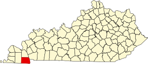
Trigg County is a county located on the far southwest border of the U.S. state of Kentucky. As of the 2020 census, the population was 14,061. Its county seat is Cadiz. Formed in 1820, the county was named for Stephen Trigg, an officer in the American Revolutionary War who was killed at the Battle of Blue Licks, now in Robertson County, Kentucky. It was a victory for British and allied troops.

<span class="mw-page-title-main">Taylor County, Kentucky</span> County in Kentucky, United States

Taylor County is a county located in the U.S. state of Kentucky. As of the 2020 census, the population was 26,023. Its county seat is Campbellsville. Settled by people from Virginia, Pennsylvania, Maryland, and North Carolina after the American Revolutionary War, the county was organized in 1848 in the Highland Rim region. It is named for United States Army General Zachary Taylor, later President of the United States. Taylor County was the 100th of the 120 counties created by Kentucky. The Campbellsville Micropolitan Statistical Area includes all of Taylor County.

<span class="mw-page-title-main">Robertson County, Kentucky</span> County in Kentucky, United States

Robertson County is a county located in the U.S. Commonwealth of Kentucky. As of the 2020 census, the population was 2,193. Its county seat is Mount Olivet. The county is named for George Robertson, a Kentucky Congressman from 1817 to 1821. It is Kentucky's smallest county by both total area and by population.

<span class="mw-page-title-main">Powell County, Kentucky</span> County in Kentucky, United States

Powell County is a county located in the U.S. Commonwealth of Kentucky. As of the 2020 census, the population was 13,129. Its county seat is Stanton. The county was formed January 7, 1852, by Kentucky Governor Lazarus W. Powell from parts of Clark, Estill, and Montgomery counties. It is no longer a dry county as of 2018. Powell County is home to Natural Bridge State Resort Park and the Red River Gorge Geologic Area, two of Kentucky's most important natural areas and ecotourism destinations, as well as the Pilot Knob State Nature Preserve.

<span class="mw-page-title-main">Mercer County, Kentucky</span> County in Kentucky, United States

Mercer County is a county located in the central part of the U.S. Commonwealth of Kentucky. As of the 2020 census, the population was 23,772. Its county seat is Harrodsburg. The county was formed from Lincoln County, Virginia in 1785 and is named for Revolutionary War General Hugh Mercer, who was killed at the Battle of Princeton in 1777. It was formerly a prohibition or dry county.

<span class="mw-page-title-main">Meade County, Kentucky</span> County in Kentucky, United States

Meade County is a county located in the U.S. state of Kentucky. As of the 2020 census, the population was 30,003. Its county seat is Brandenburg. The county was founded December 17, 1823, and named for Captain James M. Meade, who was killed in action at the Battle of River Raisin during the War of 1812. Meade County is part of the Elizabethtown-Fort Knox, KY Metropolitan Statistical Area, which is included in the Louisville/Jefferson County-Elizabethtown-Madison, KY-IN Combined Statistical Area.

<span class="mw-page-title-main">Martin County, Kentucky</span> County in Kentucky, United States

Martin County is a county located in the U.S. state of Kentucky. As of the 2020 census, the population was 11,287. Its county seat is Inez. The county was founded in 1870 and is named for Congressman John Preston Martin. Warfield, Kentucky, is the only non-dry city in the county.

<span class="mw-page-title-main">Lyon County, Kentucky</span> County in Kentucky, United States

Lyon County is a county located in the U.S. state of Kentucky. As of the 2020 census, the population was 8,680. Its county seat is Eddyville. The county was formed from Caldwell County, Kentucky in 1854 and named for former Congressman Chittenden Lyon.

<span class="mw-page-title-main">Livingston County, Kentucky</span> County in Kentucky, United States

Livingston County is a county located in the U.S. state of Kentucky. As of the 2020 census, the population was 8,888. Its county seat is Smithland and its largest community is Ledbetter. The county was established in 1798 from land taken from Christian County and is named for Robert R. Livingston, a member of the Committee of Five that drafted the U.S. Declaration of Independence. The county was strongly pro-Confederate during the American Civil War and many men volunteered for the Confederate Army. Livingston County is part of the Paducah, KY-IL Metropolitan Statistical Area. It is a prohibition or dry county with the exception of Grand Rivers which voted to allow alcohol sales in 2016.

<span class="mw-page-title-main">Lawrence County, Kentucky</span> County in Kentucky, United States

Lawrence County is a county located in the U.S. state of Kentucky. As of the 2020 census, the population was 16,293. Its county seat is Louisa. The county is named for James Lawrence, and co-founded by Isaac Bolt, who served as a Lawrence County Commissioner and Justice of the Peace. Lawrence County is the home of bluegrass music and country music star Tyler Childers. It is the birthplace of the late Chief Justice of the United States Frederick Moore Vinson and former Kentucky Governor Paul E. Patton. In regard to alcoholic beverage sales, Lawrence County is considered a "moist" county, meaning alcohol sales are only allowed within the city limits of Louisa. There are no alcohol sales within the rest of the county. Only two stores sell liquor, and most convenience stores sell beer and malted beverages.

<span class="mw-page-title-main">Kenton County, Kentucky</span> County in Kentucky, United States

Kenton County is a county located in the northern part of the Commonwealth of Kentucky. As of the 2020 census, the population was 169,064, making it the third most populous county in Kentucky. Its county seats are Covington and Independence. It was, until November 24, 2010, the only county in Kentucky to have two legally recognized county seats. The county was formed in 1840 and is named for Simon Kenton, a frontiersman notable in the early history of the state.

<span class="mw-page-title-main">Hickman County, Kentucky</span> County in Kentucky, United States

Hickman County is a county located in the U.S. state of Kentucky. As of the 2020 census, the population was 4,521, making it the third-least populous county in Kentucky. Its county seat is Clinton. The county was formed in 1821. It is the least densely populated county in the state and is a prohibition or dry county.

<span class="mw-page-title-main">Graves County, Kentucky</span> County in Kentucky, United States

Graves County is a county located on the southwest border of the U.S. Commonwealth of Kentucky. As of the 2020 census, the population was 36,649. Its county seat is Mayfield. The county was formed in 1824 and was named for Major Benjamin Franklin Graves, a politician and fallen soldier in the War of 1812.

<span class="mw-page-title-main">Christian County, Kentucky</span> County in Kentucky, United States

Christian County is a county located in the U.S. state of Kentucky. As of the 2020 census, the population was 72,748. Its county seat is Hopkinsville. The county was formed in 1797. Christian County is part of the Clarksville, Tennessee–Kentucky Metropolitan Statistical Area.

<span class="mw-page-title-main">Carlisle County, Kentucky</span> County in Kentucky, United States

Carlisle County is a county located in the U.S. state of Kentucky. As of the 2020 census, the population was 4,826, making it the fourth-least populous county in Kentucky. Its county seat is Bardwell. The county was founded in 1886 and named for John Griffin Carlisle, a Speaker of the United States House of Representatives from Kentucky. It remains a prohibition or dry county. Carlisle County is included in the Paducah, KY-IL, Metropolitan Statistical Area.

Branch is a city in Franklin County, Arkansas, United States. It is part of the Fort Smith, Arkansas-Oklahoma Metropolitan Statistical Area. The population was 367 at the 2010 census.

<span class="mw-page-title-main">Hazel, Kentucky</span> City in Kentucky, United States

Hazel is a home rule-class city in Calloway County, Kentucky, United States. The population was 410 at the 2010 census.

<span class="mw-page-title-main">Murray, Kentucky</span> City in Kentucky, United States

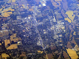
Murray is a home rule-class city in Calloway County, Kentucky, United States. It is the seat of Calloway County and the 19th-largest city in Kentucky. The city's population was 17,741 during the 2010 U.S. census, and its micropolitan area's population is 37,191. Murray is a college town and is the home of Murray State University.

<span class="mw-page-title-main">Fort Mitchell, Kentucky</span> City in Kentucky, United States

Fort Mitchell is a home rule-class city in Kenton County, Kentucky, United States. The population was 8,702 at the 2020 census. It is part of the Cincinnati metropolitan area.

References

  1. 1 2 "State & County QuickFacts". United States Census Bureau. Retrieved July 7, 2022.
  2. "Find a County". National Association of Counties. Archived from the original on May 31, 2011. Retrieved June 7, 2011.
  3. "Calloway County". The Kentucky Encyclopedia. 2000. Archived from the original on September 30, 2018. Retrieved August 21, 2014.
  4. Hogan, Roseann Reinemuth (1992). Kentucky Ancestry: A Guide to Genealogical and Historical Research. Ancestry Publishing. p. 207. ISBN   9780916489496 . Retrieved July 26, 2013.
  5. "Murray, Kentucky History". www.explorekentuckylake.com. Retrieved April 23, 2016.
  6. "2010 Census Gazetteer Files". United States Census Bureau. August 22, 2012. Archived from the original on August 12, 2014. Retrieved August 13, 2014.
  7. "Annual Estimates of the Resident Population for Counties: April 1, 2020 to July 1, 2023". United States Census Bureau. Retrieved March 14, 2024.
  8. "U.S. Decennial Census". United States Census Bureau. Retrieved August 13, 2014.
  9. "Historical Census Browser". University of Virginia Library. Retrieved August 13, 2014.
  10. "Population of Counties by Decennial Census: 1900 to 1990". United States Census Bureau. Retrieved August 13, 2014.
  11. "Census 2000 PHC-T-4. Ranking Tables for Counties: 1990 and 2000" (PDF). United States Census Bureau. Archived (PDF) from the original on March 27, 2010. Retrieved August 13, 2014.
  12. "U.S. Census website". United States Census Bureau . Retrieved January 31, 2008.
  13. Leip, David. "Dave Leip's Atlas of U.S. Presidential Elections". uselectionatlas.org. Retrieved February 22, 2021.

36°37′N88°16′W / 36.62°N 88.27°W / 36.62; -88.27