Mason County, Kentucky

Last updated

Mason County
MasonCountyCourthouse.jpg
The Mason County courthouse in Maysville
Map of Kentucky highlighting Mason County.svg
Location within the U.S. state of Kentucky
Kentucky in United States.svg
Kentucky's location within the U.S.
Coordinates: 38°36′N83°50′W / 38.6°N 83.83°W / 38.6; -83.83
CountryFlag of the United States.svg United States
StateFlag of Kentucky.svg  Kentucky
Founded1788
Named for George Mason
Seat Maysville
Largest cityMaysville
Area
  Total246 sq mi (640 km2)
  Land240 sq mi (600 km2)
  Water6.3 sq mi (16 km2)  2.6%
Population
 (2020)
  Total17,120
  Estimate 
(2023)
16,841 Decrease2.svg
  Density70/sq mi (27/km2)
Time zone UTC−5 (Eastern)
  Summer (DST) UTC−4 (EDT)
Congressional district 4th
Website masoncountykentucky.us

Mason County is a county located in the U.S. state of Kentucky. As of the 2020 census, the population was 17,120. [1] Its county seat is Maysville. [2] The county was created from Bourbon County, Virginia in 1788 and named for George Mason, a Virginia delegate to the U.S. Constitutional Convention known as the "Father of the Bill of Rights". [3] [4] Mason County comprises the Maysville, KY Micropolitan Statistical Area, which is included in the Cincinnati-Wilmington-Maysville, OH-KY-IN Combined Statistical Area.

Contents

Geography

According to the United States Census Bureau, the county has a total area of 246 square miles (640 km2), of which 240 square miles (620 km2) is land and 6.3 square miles (16 km2) (2.6%) is water. [5] The county's northern border with Ohio is formed by the Ohio River.

Adjacent counties

Demographics

Historical population
CensusPop.Note
1790 2,729
1800 12,182346.4%
1810 12,4592.3%
1820 13,5889.1%
1830 16,19919.2%
1840 15,719−3.0%
1850 18,34416.7%
1860 18,222−0.7%
1870 18,126−0.5%
1880 20,46912.9%
1890 20,7731.5%
1900 20,446−1.6%
1910 18,611−9.0%
1920 17,760−4.6%
1930 18,8626.2%
1940 19,0661.1%
1950 18,486−3.0%
1960 18,454−0.2%
1970 17,273−6.4%
1980 17,7652.8%
1990 16,666−6.2%
2000 16,8000.8%
2010 17,4904.1%
2020 17,120−2.1%
2023 (est.)16,841 [6] −1.6%
U.S. Decennial Census [7]
1790-1960 [8] 1900-1990 [9]
1990-2000 [10] 2010-2020 [1]

As of the census of 2000, there were 16,800 people, 6,847 households, and 4,697 families residing in the county. The population density was 70 per square mile (27/km2). There were 7,754 housing units at an average density of 32 per square mile (12/km2). The racial makeup of the county was 90.88% White, 7.16% Black or African American, 0.15% Native American, 0.37% Asian, 0.02% Pacific Islander, 0.57% from other races, and 0.85% from two or more races. 0.95% of the population were Hispanic or Latino of any race.

There were 6,847 households, out of which 31.30% had children under the age of 18 living with them, 54.20% were married couples living together, 11.10% had a female householder with no husband present, and 31.40% were non-families. 27.60% of all households were made up of individuals, and 12.80% had someone living alone who was 65 years of age or older. The average household size was 2.41 and the average family size was 2.92.

In the county, the population was spread out, with 24.10% under the age of 18, 8.00% from 18 to 24, 28.50% from 25 to 44, 23.90% from 45 to 64, and 15.50% who were 65 years of age or older. The median age was 38 years. For every 100 females, there were 93.70 males. For every 100 females age 18 and over, there were 89.50 males.

The median income for a household in the county was $30,195, and the median income for a family was $37,257. Males had a median income of $30,718 versus $21,216 for females. The per capita income for the county was $16,589. About 12.90% of families and 16.80% of the population were below the poverty line, including 23.60% of those under age 18 and 13.70% of those age 65 or over.

Communities

Cities

Census-designated place

Other unincorporated places

Politics

Mason County was at the time of the Civil War the easternmost of the strongly secessionist Bluegrass bloc. [11] Mason was in fact the most easterly Kentucky county to be represented at the Russellville Convention of 1861 to discuss the secession of Kentucky from the Union.

Mason County's secessionist sentiment meant that it voted Democratic consistently up until the 1950s, with the exception of the 1928 election when strong local anti-Catholic sentiment against Al Smith allowed Herbert Hoover to carry the county. Since 1996 the county has shifted more strongly Republican in US presidential elections.

United States presidential election results for Mason County, Kentucky [12]
Year Republican Democratic Third party
No.%No.%No.%
2020 5,47768.82%2,36229.68%1191.50%
2016 4,94468.49%1,97027.29%3054.22%
2012 4,19760.99%2,59237.67%921.34%
2008 4,10257.60%2,89140.60%1281.80%
2004 4,38161.89%2,64437.35%540.76%
2000 3,57260.82%2,17837.08%1232.09%
1996 2,58846.72%2,44444.12%5079.15%
1992 2,43240.34%2,65744.07%94015.59%
1988 3,15853.57%2,72146.16%160.27%
1984 3,75158.19%2,66341.31%320.50%
1980 2,92646.54%3,18150.60%1802.86%
1976 2,52942.12%3,39756.58%781.30%
1972 3,52958.46%2,45940.73%490.81%
1968 2,66140.50%2,77242.19%1,13717.31%
1964 2,43735.05%4,50264.76%130.19%
1960 4,33457.89%3,15342.11%00.00%
1956 3,88051.80%3,57247.69%380.51%
1952 3,60649.89%3,61450.00%80.11%
1948 2,51940.13%3,62057.67%1382.20%
1944 3,25645.83%3,81053.62%390.55%
1940 3,70445.63%4,38654.03%270.33%
1936 3,31741.63%4,50356.52%1471.85%
1932 3,21338.55%5,06560.78%560.67%
1928 5,01259.79%3,36440.13%60.07%
1924 3,40648.28%3,52549.96%1241.76%
1920 3,74344.16%4,69155.34%420.50%
1916 2,12742.54%2,82056.40%531.06%
1912 1,55833.83%2,47553.75%57212.42%

Education

Mason County Schools operates public schools.

Schools:

In 1990 the Maysville Independent School District merged into the Mason County school district. [13]

Notable residents

See also

Related Research Articles

<span class="mw-page-title-main">Simpson County, Kentucky</span> County in Kentucky, United States

Simpson County is a county located in the south central portion of the U.S. state of Kentucky. As of the 2020 census, the total population was 19,594. Its county seat is Franklin.

<span class="mw-page-title-main">Pendleton County, Kentucky</span> County in Kentucky, United States

Pendleton County is a county located in the U.S. state of Kentucky. As of the 2020 census, the population was 14,644. Its county seat is Falmouth. The county was founded December 13, 1798. Pendleton County is included in the Cincinnati-Middletown, OH-KY-IN Metropolitan Statistical Area.

<span class="mw-page-title-main">Oldham County, Kentucky</span> County in Kentucky, United States

Oldham County is a county located in the north central part of the U.S. state and commonwealth of Kentucky. As of the 2020 census, the population was 67,607. Its county seat is La Grange. The county is named for Colonel William Oldham.

<span class="mw-page-title-main">Meade County, Kentucky</span> County in Kentucky, United States

Meade County is a county located in the U.S. state of Kentucky. As of the 2020 census, the population was 30,003. Its county seat is Brandenburg. The county was founded December 17, 1823, and named for Captain James M. Meade, who was killed in action at the Battle of River Raisin during the War of 1812. Meade County is part of the Elizabethtown-Fort Knox, KY Metropolitan Statistical Area, which is included in the Louisville/Jefferson County-Elizabethtown-Madison, KY-IN Combined Statistical Area.

<span class="mw-page-title-main">Lewis County, Kentucky</span> County in Kentucky, United States

Lewis County is a county located in the U.S. state of Kentucky. As of the 2020 census, the population was 13,080. Its county seat is Vanceburg.

<span class="mw-page-title-main">Kenton County, Kentucky</span> County in Kentucky, United States

Kenton County is a county located in the northern part of the Commonwealth of Kentucky. As of the 2020 census, the population was 169,064, making it the third most populous county in Kentucky. Its county seats are Covington and Independence. It was, until November 24, 2010, the only county in Kentucky to have two legally recognized county seats. The county was formed in 1840 and is named for Simon Kenton, a frontiersman notable in the early history of the state.

<span class="mw-page-title-main">Campbell County, Kentucky</span> County in Kentucky, United States

Campbell County is a county located in the northern part of the U.S. state of Kentucky. As of the 2020 census, the population was 93,076. Its county seats are Alexandria and Newport. The county was formed on December 17, 1794, from sections of Scott, Harrison, and Mason Counties and was named for Colonel John Campbell (1735–1799), a Revolutionary War soldier and Kentucky legislator. Campbell County, with Boone and Kenton Counties, is part of the Northern Kentucky metro community, and the Cincinnati-Middletown, OH-KY-IN Metropolitan Statistical Area.

<span class="mw-page-title-main">Bracken County, Kentucky</span> County in Kentucky, United States

Bracken County is a county located in the U.S. state of Kentucky. As of the 2020 census, the population was 8,400. Its county seat is Brooksville. The county was formed in 1796. Bracken County is included in the Cincinnati-Middletown, OH-KY-IN Metropolitan Statistical Area.

<span class="mw-page-title-main">Bourbon County, Kentucky</span> County in Kentucky, United States

Bourbon County is a county located in the U.S. state of Kentucky. As of the 2020 census, the population was 20,252. Its county seat is Paris. Bourbon County is part of the Lexington-Fayette, KY Metropolitan Statistical Area. It is one of Kentucky's nine original counties, and is best known for its historical association with bourbon whiskey.

<span class="mw-page-title-main">Alexandria, Kentucky</span> City in Kentucky, United States

Alexandria is a home rule-class city in Campbell County, Kentucky, in the United States. Along with Newport, it is one of the dual seats of the county. The population was 10,341 at the 2020 census.

<span class="mw-page-title-main">Cold Spring, Kentucky</span> City in Kentucky, United States

Cold Spring is a home rule-class city in Campbell County, Kentucky, in the United States. The population was 6,216 at the 2020 census. It is part of the Cincinnati-Northern Kentucky metropolitan area.

<span class="mw-page-title-main">Cynthiana, Kentucky</span> City in Kentucky, United States

Cynthiana is a home rule-class city in Harrison County, Kentucky, in the United States. The population was 6,402 at the 2010 census. It is the seat of its county.

<span class="mw-page-title-main">Concord, Kentucky</span> City in Kentucky, United States

Concord is a home rule-class city in Lewis County, Kentucky, in the United States. The population was 35 at the 2010 census. It is part of the Maysville Micropolitan Statistical Area.

<span class="mw-page-title-main">Vanceburg, Kentucky</span> City in Kentucky, United States

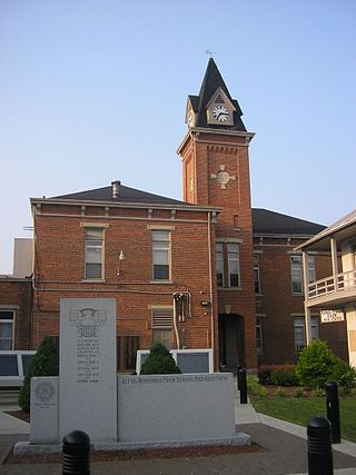
Vanceburg is a home rule-class city in Lewis County, Kentucky, United States, along the Ohio River. The population was 1,428 at the 2020 census. It is the county seat of Lewis County.

<span class="mw-page-title-main">Dover, Kentucky</span> City in Kentucky, United States

Dover is a home rule-class city in Mason County, Kentucky, United States. The population was 221 at the 2020 census, down from 252 in 2010. It is part of the Maysville Micropolitan Statistical Area.

<span class="mw-page-title-main">Maysville, Kentucky</span> City in Kentucky, United States

Maysville is a home rule-class city in Mason County, Kentucky, United States, and is the seat of Mason County. The population was 8,873 as of the 2020 census. Maysville is on the Ohio River, 66 miles (106 km) northeast of Lexington. It is the principal city of the Maysville Micropolitan Statistical Area, which comprises Mason County. Two bridges cross the Ohio from Maysville to Aberdeen, Ohio: the Simon Kenton Memorial Bridge built in 1931 and the William H. Harsha Bridge built in 2001.

<span class="mw-page-title-main">Sardis, Kentucky</span> City in Kentucky, United States

Sardis is a home rule-class city in Mason and Robertson counties in the U.S. state of Kentucky. The population was 60 as of the 2020 census, down from 103 in 2010.

<span class="mw-page-title-main">Germantown, Kentucky</span> City in Kentucky, United States

Germantown is a home rule-class city in Bracken and Mason counties in the U.S. state of Kentucky. The population was 146 at the 2020 census.

<span class="mw-page-title-main">Knox County, Kentucky</span> County in Kentucky, United States

Knox County is a county located in Appalachia near the southeastern corner of the U.S. state of Kentucky. As of the 2020 census, the population was 30,193. Its county seat is Barbourville. The county is named for General Henry Knox. It is one of the few coal-producing counties in Kentucky that has not suffered massive population loss. Knox County is included in the London, KY Micropolitan Statistical Area.

<span class="mw-page-title-main">Baileyville, Kansas</span> Unincorporated community in Nemaha County, Kansas

Baileyville is an unincorporated community in western Nemaha County, Kansas, United States. As of the 2020 census, the population of the community and nearby areas was 182. It is located six miles west of Seneca on U.S. Route 36.

References

  1. 1 2 "State & County QuickFacts". United States Census Bureau. Retrieved February 24, 2023.
  2. "Find a County". National Association of Counties. Retrieved June 7, 2011.
  3. "Mason County". The Kentucky Encyclopedia. 2000. Archived from the original on September 3, 2013. Retrieved August 23, 2014.
  4. Collins, Lewis (1882). Collins' Historical Sketches of Kentucky: History of Kentucky, Volume 2. Collins & Company. p. 26.
  5. "2010 Census Gazetteer Files". United States Census Bureau. August 22, 2012. Archived from the original on August 12, 2014. Retrieved August 17, 2014.
  6. "Annual Estimates of the Resident Population for Counties: April 1, 2020 to July 1, 2023". United States Census Bureau. Retrieved March 14, 2024.
  7. "U.S. Decennial Census". United States Census Bureau. Retrieved August 17, 2014.
  8. "Historical Census Browser". University of Virginia Library. Retrieved August 17, 2014.
  9. "Population of Counties by Decennial Census: 1900 to 1990". United States Census Bureau. Retrieved August 17, 2014.
  10. "Census 2000 PHC-T-4. Ranking Tables for Counties: 1990 and 2000" (PDF). United States Census Bureau. Archived (PDF) from the original on March 27, 2010. Retrieved August 17, 2014.
  11. Copeland, James E.; 'Where Were the Kentucky Unionists and Secessionists'; The Register of the Kentucky Historical Society, volume 71, no. 4 (October, 1973), pp. 344-363
  12. Leip, David. "Dave Leip's Atlas of U.S. Presidential Elections". uselectionatlas.org. Retrieved July 4, 2018.
  13. Ellis, Ronnie (January 15, 2007). "The ups and downs of merging school districts". Richmond Register . Retrieved May 21, 2018.

38°36′N83°50′W / 38.60°N 83.83°W / 38.60; -83.83