Lawrence County, Kentucky

Last updated

Lawrence County
Lawrence County Courthouse in Louisa from south.jpg
Lawrence County Courthouse in Louisa
Map of Kentucky highlighting Lawrence County.svg
Location within the U.S. state of Kentucky
Kentucky in United States.svg
Kentucky's location within the U.S.
Coordinates: 38°04′N82°44′W / 38.06°N 82.73°W / 38.06; -82.73
CountryFlag of the United States.svg United States
StateFlag of Kentucky.svg  Kentucky
FoundedDecember 14, 1821
Named for James Lawrence
Seat Louisa
Largest cityLouisa
Area
  Total420 sq mi (1,100 km2)
  Land416 sq mi (1,080 km2)
  Water4.5 sq mi (12 km2)  1.1%
Population
 (2020)
  Total16,293
  Estimate 
(2023)
16,000 Decrease2.svg
  Density39/sq mi (15/km2)
Time zone UTC−5 (Eastern)
  Summer (DST) UTC−4 (EDT)
Congressional district 5th
Website lawrencecountyky.gov

Lawrence County is a county located in the U.S. state of Kentucky. As of the 2020 census, the population was 16,293. [1] Its county seat is Louisa. [2] The county is named for James Lawrence, [3] and co-founded by Isaac Bolt, who served as a Lawrence County Commissioner and Justice of the Peace. Lawrence County is the home of bluegrass music and country music star Tyler Childers. It is the birthplace of the late Chief Justice of the United States Frederick Moore Vinson and former Kentucky Governor Paul E. Patton. In regard to alcoholic beverage sales, Lawrence County is considered a "moist" county, meaning alcohol sales are only allowed within the city limits of Louisa. There are no alcohol sales within the rest of the county. Only two stores sell liquor (to prevent a monopoly), and most convenience stores sell beer and malted beverages.

Contents

History

Lawrence County was established in 1821 from land given by Floyd and Greenup Counties. [4] Four courthouses have served Lawrence County; the first was completed in 1823. [5]

Geography

According to the United States Census Bureau, the county has a total area of 420 square miles (1,100 km2), of which 416 square miles (1,080 km2) is land and 4.5 square miles (12 km2) (1.1%) is water. [6]

The bridge from Louisa, in eastern Lawrence County, to Fort Gay, West Virginia is something of a geographic and architectural oddity. The quarter-mile concrete span spans across the Levisa Fork and the Tug River that come together and form the Big Sandy River, connects two states and has a right turn at its halfway point, which connects traffic to the Point Section neighborhood of Louisa.

Yatesville Lake State Park

Yatesville Lake was opened in 1992 and is a 2,300 acres (9.3 km2) reservoir managed by the Army Corps of Engineers. Yatesville Lake provides flood control for the region as well as recreational opportunities. The Corps manages a boat ramp at the Rich Creek area.

Bordering Counties

Demographics

Historical population
CensusPop.Note
1830 3,900
1840 4,73021.3%
1850 6,28132.8%
1860 7,60121.0%
1870 8,49711.8%
1880 13,26256.1%
1890 17,70233.5%
1900 19,61210.8%
1910 20,0672.3%
1920 17,643−12.1%
1930 16,713−5.3%
1940 17,2753.4%
1950 14,418−16.5%
1960 12,134−15.8%
1970 10,726−11.6%
1980 14,12131.7%
1990 13,998−0.9%
2000 15,56911.2%
2010 15,8601.9%
2020 16,2932.7%
2023 (est.)16,000 [7] −1.8%
U.S. Decennial Census [8]
1790-1960 [9] 1900-1990 [10]
1990-2000 [11] 2010-2020 [1]

As of the census of 2000, there were 15,569 people, 5,954 households, and 4,477 families in the county. The population density was 37 per square mile (14/km2). There were 7,040 housing units at an average density of 17 per square mile (6.6/km2). The racial makeup of the county was 98.93% White, 0.10% Black or African American, 0.28% Native American, 0.07% Asian, 0.01% Pacific Islander, 0.05% from other races, and 0.56% from two or more races. 0.41%. [12] were Hispanic or Latino of any race.

Of the 5,954 households 35.00% had children under the age of 18 living with them, 61.30% were married couples living together, 10.50% had a female householder with no husband present, and 24.80% were non-families. 22.40% of households were one person and 10.00% were one person aged 65 or older. The average household size was 2.59 and the average family size was 3.02.

The age distribution was 25.30% under the age of 18, 8.80% from 18 to 24, 28.70% from 25 to 44, 24.70% from 45 to 64, and 12.40% 65 or older. The median age was 36 years. For every 100 females, there were 97.30 males. For every 100 females age 18 and over, there were 93.00 males.

The median household income was $21,610 and the median family income was $26,113. Males had a median income of $30,735 versus $19,174 for females. The per capita income for the county was $12,008. About 25.30% of families and 30.70% of the population were below the poverty line, including 40.00% of those under age 18 and 27.30% of those age 65 or over.

Politics

Lawrence County is a state bellwether in presidential elections, having voted for Kentucky's statewide winner in every election since 1956. [13]

United States presidential election results for Lawrence County, Kentucky [14]
Year Republican Democratic Third party
No.%No.%No.%
2020 5,63380.99%1,23817.80%841.21%
2016 4,81679.71%1,04517.30%1813.00%
2012 3,99571.44%1,52027.18%771.38%
2008 3,50362.01%2,03636.04%1101.95%
2004 3,75557.65%2,70541.53%530.81%
2000 2,96955.94%2,25842.55%801.51%
1996 1,81240.24%2,19548.75%49611.01%
1992 2,08441.21%2,40047.46%57311.33%
1988 2,29450.89%2,19848.76%160.35%
1984 2,71354.71%2,22344.83%230.46%
1980 2,56451.49%2,36247.43%541.08%
1976 1,83842.91%2,40256.08%431.00%
1972 2,39260.48%1,52938.66%340.86%
1968 1,94645.80%1,82542.95%47811.25%
1964 1,74539.17%2,70360.67%70.16%
1960 3,03054.69%2,51045.31%00.00%
1956 2,93253.92%2,49545.88%110.20%
1952 2,69650.85%2,59748.98%90.17%
1948 2,11746.50%2,37252.10%641.41%
1944 2,71552.87%2,40846.89%120.23%
1940 3,05548.86%3,17850.83%190.30%
1936 2,94448.04%3,17551.81%90.15%
1932 2,76642.59%3,70156.99%270.42%
1928 3,27759.59%2,21740.32%50.09%
1924 2,54750.16%2,44548.15%861.69%
1920 2,84952.44%2,55847.08%260.48%
1916 1,92849.67%1,91049.20%441.13%
1912 1,28035.48%1,64845.68%68018.85%

Communities

See also

Related Research Articles

<span class="mw-page-title-main">Montgomery County, Kentucky</span> County in Kentucky, United States

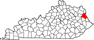
Montgomery County is a county located in the U.S. state of Kentucky. As of the 2020 census, the population was 28,114. Its county seat is Mount Sterling. With regard to the sale of alcohol, it is classified as a moist county—a county in which alcohol sales are prohibited, but containing a "wet" city where package alcohol sales are allowed, in this case Mount Sterling. Montgomery County is part of the Mount Sterling, KY Micropolitan Statistical Area, which is also included in the Lexington-Fayette–Richmond–Frankfort, KY combined statistical area.

<span class="mw-page-title-main">Walthall County, Mississippi</span> County in Mississippi, United States

Walthall County is a county located in the U.S. state of Mississippi. As of the 2020 census, the population was 13,884. Its county seat is Tylertown. The county is named after Civil War Confederate general and Mississippi Senator Edward C. Walthall.

<span class="mw-page-title-main">Trigg County, Kentucky</span> County in Kentucky, United States

Trigg County is a county located on the far southwest border of the U.S. state of Kentucky. As of the 2020 census, the population was 14,061. Its county seat is Cadiz. Formed in 1820, the county was named for Stephen Trigg, an officer in the American Revolutionary War who was killed at the Battle of Blue Licks, now in Robertson County, Kentucky. It was a victory for British and allied troops.

<span class="mw-page-title-main">Spencer County, Kentucky</span> County in Kentucky, United States

Spencer County is a county located in the U.S. state of Kentucky. As of the 2020 census, the total population was 19,490. Its county seat is Taylorsville. The county was founded in 1824 and named for Spier Spencer.

<span class="mw-page-title-main">Robertson County, Kentucky</span> County in Kentucky, United States

Robertson County is a county located in the U.S. Commonwealth of Kentucky. As of the 2020 census, the population was 2,193. Its county seat is Mount Olivet. The county is named for George Robertson, a Kentucky Congressman from 1817 to 1821. It is Kentucky's smallest county by both total area and by population.

<span class="mw-page-title-main">Powell County, Kentucky</span> County in Kentucky, United States

Powell County is a county located in the U.S. Commonwealth of Kentucky. As of the 2020 census, the population was 13,129. Its county seat is Stanton. The county was formed January 7, 1852, by Kentucky Governor Lazarus W. Powell from parts of Clark, Estill, and Montgomery counties. It is no longer a dry county as of 2018. Powell County is home to Natural Bridge State Resort Park and the Red River Gorge Geologic Area, two of Kentucky's most important natural areas and ecotourism destinations, as well as the Pilot Knob State Nature Preserve.

<span class="mw-page-title-main">Morgan County, Kentucky</span> County in Kentucky, United States

Morgan County is a county located in the U.S. state of Kentucky. As of the 2020 census, the population was 13,726. Its county seat is West Liberty. The county is among the dry counties, which means that the sale of alcohol is restricted or prohibited.

<span class="mw-page-title-main">Metcalfe County, Kentucky</span> County in Kentucky, United States

Metcalfe County is a county located in the U.S. state of Kentucky. Its county seat and only municipality is Edmonton. The county was founded in May 1860 and named for Thomas Metcalfe, Governor of Kentucky from 1828 to 1832. Metcalfe County is part of the Glasgow, KY Micropolitan Statistical Area, which is also included in the Bowling Green-Glasgow, KY Combined Statistical Area.

<span class="mw-page-title-main">Mason County, Kentucky</span> County in Kentucky, United States

Mason County is a county located in the U.S. state of Kentucky. As of the 2020 census, the population was 17,120. Its county seat is Maysville. The county was created from Bourbon County, Virginia in 1788 and named for George Mason, a Virginia delegate to the U.S. Constitutional Convention known as the "Father of the Bill of Rights". Mason County comprises the Maysville, KY Micropolitan Statistical Area, which is included in the Cincinnati-Wilmington-Maysville, OH-KY-IN Combined Statistical Area.

<span class="mw-page-title-main">Lyon County, Kentucky</span> County in Kentucky, United States

Lyon County is a county located in the U.S. state of Kentucky. As of the 2020 census, the population was 8,680. Its county seat is Eddyville. The county was formed from Caldwell County, Kentucky in 1854 and named for former Congressman Chittenden Lyon.

<span class="mw-page-title-main">Livingston County, Kentucky</span> County in Kentucky, United States

Livingston County is a county located in the U.S. state of Kentucky. As of the 2020 census, the population was 8,888. Its county seat is Smithland and its largest community is Ledbetter. The county was established in 1798 from land taken from Christian County and is named for Robert R. Livingston, a member of the Committee of Five that drafted the U.S. Declaration of Independence. The county was strongly pro-Confederate during the American Civil War and many men volunteered for the Confederate Army. Livingston County is part of the Paducah, KY-IL Metropolitan Statistical Area. It is a prohibition or dry county with the exception of Grand Rivers which voted to allow alcohol sales in 2016.

<span class="mw-page-title-main">Henry County, Kentucky</span> County in Kentucky, United States

Henry County is a county located in the north central portion of the U.S. state of Kentucky bordering the Kentucky River. As of the 2020 census, the population was 15,678. Its county seat is New Castle, but its largest city is Eminence. The county was founded in 1798 from portions of Shelby County. It was named for the statesman and governor of Virginia Patrick Henry. Henry County is included in the Louisville/Jefferson County, KY-IN Metropolitan Statistical Area. Since the 1990s, it has become an increasingly important exurb, especially as land prices have become higher in neighboring Oldham County. With regard to the sale of alcohol, it is classified as a wet county.

<span class="mw-page-title-main">Harrison County, Kentucky</span> County in Kentucky, United States

Harrison County is a county located in the U.S. state of Kentucky. As of the 2020 census, the population was 18,692. Its county seat is Cynthiana. The county was founded in 1793 and named for Colonel Benjamin Harrison, an advocate for Kentucky statehood, framer of the Kentucky Constitution, and Kentucky legislator.

<span class="mw-page-title-main">Hancock County, Kentucky</span> County in Kentucky, United States

Hancock County is a county located in the U.S. state of Kentucky. As of the 2020 census, the population was 9,095. Its county seat is in the city of Hawesville located in the Northern part of the county, and its largest city of Lewisport is located in the Northwestern part of the county.

<span class="mw-page-title-main">Fleming County, Kentucky</span> County in Kentucky, United States

Fleming County is a county located in the U.S. state of Kentucky. As of the 2020 census, the population was 15,082. Its county seat is Flemingsburg. The county was formed in 1798 and named for Colonel John Fleming, an Indian fighter and early settler. It is a moist county. In 1998, the Kentucky General Assembly designated Fleming County as the Covered Bridge Capital of Kentucky.

<span class="mw-page-title-main">Christian County, Kentucky</span> County in Kentucky, United States

Christian County is a county located in the U.S. state of Kentucky. As of the 2020 census, the population was 72,748. Its county seat is Hopkinsville. The county was formed in 1797. Christian County is part of the Clarksville, Tennessee–Kentucky Metropolitan Statistical Area.

<span class="mw-page-title-main">Carter County, Kentucky</span> County in Kentucky, United States

Carter County is a county located in the U.S. state of Kentucky. As of the 2020 census, the population was 26,627. Its county seat is Grayson. Carter County is in the Huntington-Ashland, WV-KY-OH Metropolitan Statistical Area. It is home to Carter Caves State Resort Park.

<span class="mw-page-title-main">Calloway County, Kentucky</span> County in Kentucky, United States

Calloway County is a county located on the southwest border of the U.S. Commonwealth of Kentucky. As of the 2020 census, the population was 37,103. Its county seat is Murray. The county was founded in November 1822 and named for Colonel Richard Callaway, one of the founders of Boonesborough. Calloway County comprises the Murray, KY Micropolitan Statistical Area. As of July 18, 2012 Calloway County is a moist county: the sale of alcohol in the county is prohibited, with the exception of the city of Murray.

<span class="mw-page-title-main">Ballard County, Kentucky</span> County in Kentucky, United States

Ballard County is a county located in the west portion of the U.S. state of Kentucky. As of the 2020 census, the population was 7,728. Its county seat is Wickliffe and its largest city is LaCenter. The county was created by the Kentucky State Legislature in 1842 and is named for Captain Bland Ballard, a soldier, statesman, and member of the Kentucky General Assembly. Ballard County is part of the Paducah, KY-IL Metropolitan Statistical Area.

<span class="mw-page-title-main">Louisa County, Iowa</span> County in Iowa, United States

Louisa County is a county located in the U.S. state of Iowa. As of the 2020 census, the population was 10,837. The county seat is Wapello.

References

  1. 1 2 "State & County QuickFacts". United States Census Bureau. Retrieved February 26, 2023.
  2. "Find a County". National Association of Counties. Retrieved June 7, 2011.
  3. The Register of the Kentucky State Historical Society, Volume 1. Kentucky State Historical Society. 1903. pp.  35.
  4. "Lawrence County". The Kentucky Encyclopedia. 2000. Retrieved August 22, 2014.
  5. Hogan, Roseann Reinemuth (1992). Kentucky Ancestry: A Guide to Genealogical and Historical Research. Ancestry Publishing. p. 268. ISBN   9780916489496 . Retrieved July 26, 2013.
  6. "2010 Census Gazetteer Files". United States Census Bureau. August 22, 2012. Archived from the original on August 12, 2014. Retrieved August 17, 2014.
  7. "Annual Estimates of the Resident Population for Counties: April 1, 2020 to July 1, 2023". United States Census Bureau. Retrieved March 14, 2024.
  8. "U.S. Decennial Census". United States Census Bureau. Retrieved August 17, 2014.
  9. "Historical Census Browser". University of Virginia Library. Retrieved August 17, 2014.
  10. "Population of Counties by Decennial Census: 1900 to 1990". United States Census Bureau. Retrieved August 17, 2014.
  11. "Census 2000 PHC-T-4. Ranking Tables for Counties: 1990 and 2000" (PDF). United States Census Bureau. Archived (PDF) from the original on March 27, 2010. Retrieved August 17, 2014.
  12. "U.S. Census website". United States Census Bureau . Retrieved January 31, 2008.
  13. Leip, David. "Dave Leip's Atlas of U.S. Presidential Elections". uselectionatlas.org.
  14. Leip, David. "Dave Leip's Atlas of U.S. Presidential Elections". uselectionatlas.org.

Further reading

38°04′N82°44′W / 38.06°N 82.73°W / 38.06; -82.73