Crittenden County, Kentucky

Last updated

Crittenden County
Crittenden County Courthouse, Marion.jpg
Crittenden County Courthouse in Marion
Map of Kentucky highlighting Crittenden County.svg
Location within the U.S. state of Kentucky
Kentucky in United States.svg
Kentucky's location within the U.S.
Coordinates: 37°22′N88°05′W / 37.36°N 88.09°W / 37.36; -88.09
CountryFlag of the United States.svg United States
StateFlag of Kentucky.svg  Kentucky
Founded1842
Named for John J. Crittenden
Seat Marion
Largest cityMarion
Area
  Total371 sq mi (960 km2)
  Land360 sq mi (900 km2)
  Water11 sq mi (30 km2)  3.0%
Population
 (2020)
  Total8,990
  Estimate 
(2023)
8,974 Decrease2.svg
  Density24/sq mi (9.4/km2)
Time zone UTC−6 (Central)
  Summer (DST) UTC−5 (CDT)
Congressional district 1st
Website www.marionky.gov/index.shtml

Crittenden County is a county in the U.S. state of Kentucky. At the 2020 census, the population was 8,990. [1] Its county seat and only municipality is Marion. [2] The county was formed in 1842 and named for John J. Crittenden, senator and future Governor of Kentucky. [3] [4]

Contents

History

Crittenden County, located on the Ohio and Tradewater Rivers in the Pennyroyal region of Kentucky, was created by the state legislature on April 1, 1842, from a portion of Livingston County. It became the state's 91st county, and was named for John J. Crittenden, a U.S. senator, attorney general, and governor of Kentucky. The first county seat was in Crooked Creek, but it was moved to Marion just two years later.

Crittenden County was once crossed by the Chickasaw Road, which was a part of the Old Saline Trace. This footpath was used by Native Americans when hunting game that crossed the Ohio River to the salt licks in Illinois. The first settler in the area was James Armstrong, who arrived from South Carolina in 1786 and built a log cabin. His family joined him five years later, along with other families who came to settle there. Early in the nineteenth century, Flynn's Ferry was established where the trail crossed the river.

Generally pro-Confederate during the American Civil War, the county saw little fighting, although both armies passed through it repeatedly. However, several skirmishes did place there, and the county courthouse was burned by Confederate Brigadier General Hylan B. Lyon during his raid across western Kentucky in December 1864. Lyon's men, all Kentuckians, burned a total of seven courthouses, since the Union Army was using them for barracks. The Confederates allowed the locals to remove the records before setting fire to the courthouses. [5]

Crittenden County has valuable deposits of fluorspar, zinc, porcelain, coal, limestone, and sand for making glass. Marion was primarily an industrial town in the 1840s associated with the large fluorspar mining industry. This industry peaked in 1947 and has been in slow decline since. Iron production was also a prominent industry in the mid-19th century, with several furnaces being built in the county, one owned by Andrew Jackson. Other products produced in the county include lumber, glass, modular homes, and blue crystal that was made famous by Ball canning jars. Today the county has a strong agricultural economy. In 1992, 66 percent of the population lived on farms, with 45 percent of the population reporting farming as their primary occupation. [5] [6]

Geography

According to the U.S. Census Bureau, the county has a total area of 371 square miles (960 km2), of which 360 square miles (930 km2) is land and 11 square miles (28 km2) (3.0%) is water. [7] Its northwestern border with Illinois is formed by the Ohio River.

Major highways

Adjacent counties

Demographics

Historical population
CensusPop.Note
1850 6,351
1860 8,79638.5%
1870 9,3816.7%
1880 11,68824.6%
1890 13,11912.2%
1900 15,19115.8%
1910 13,296−12.5%
1920 13,125−1.3%
1930 11,931−9.1%
1940 12,1151.5%
1950 10,818−10.7%
1960 8,648−20.1%
1970 8,493−1.8%
1980 9,2078.4%
1990 9,196−0.1%
2000 9,3842.0%
2010 9,315−0.7%
2020 8,990−3.5%
2023 (est.)8,974 [8] −0.2%
U.S. Decennial Census [9]
1790-1960 [10] 1900-1990 [11]
1990-2000 [12] 2010-2021 [13]

As of the census [14] of 2000, there were 9,384 people, 3,829 households, and 2,707 families residing in the county. The population density was 26 per square mile (10/km2). There were 4,410 housing units at an average density of 12 per square mile (4.6/km2). The racial makeup of the county was 98.24% White, 0.65% Black or African American, 0.15% Native American, 0.09% Asian, 0.14% from other races, and 0.74% from two or more races. 0.51% of the population were Hispanic or Latino of any race.

There were 3,829 households, out of which 29.60% had children under the age of 18 living with them, 58.80% were married couples living together, 8.90% had a female householder with no husband present, and 29.30% were non-families. 27.00% of all households were made up of individuals, and 13.80% had someone living alone who was 65 years of age or older. The average household size was 2.42 and the average family size was 2.93.

In the county, the population was spread out, with 23.20% under the age of 18, 8.00% from 18 to 24, 26.10% from 25 to 44, 26.40% from 45 to 64, and 16.30% who were 65 years of age or older. The median age was 40 years. For every 100 females there were 93.80 males. For every 100 females age 18 and over, there were 92.50 males.

The median income for a household in the county was $29,060, and the median income for a family was $36,462. Males had a median income of $30,509 versus $18,961 for females. The per capita income for the county was $15,262. About 14.70% of families and 19.10% of the population were below the poverty line, including 30.80% of those under age 18 and 15.70% of those age 65 or over.

Communities

Cities

Census-designated places

Other unincorporated communities

Ghost towns

Politics

Although Crittenden County was by no means pro-Union during the Civil War – only 4.02 percent of its white male population served in the Union Army vis-à-vis over six percent for Kentucky as a whole [15] – the county became strongly Republican in later years due to its deep ties to Illinois areas which came to support that party as a result of the war. Since 1884, the solitary Democrat to gain a majority in Crittenden County has been Jimmy Carter in 1976, although William Jennings Bryan won by two votes in 1896 and Bill Clinton obtained a plurality of 164 votes in 1992.

United States presidential election results for Crittenden County, Kentucky [16]
Year Republican Democratic Third party
No.%No.%No.%
2020 3,45181.35%73117.23%601.41%
2016 3,29081.50%61715.28%1303.22%
2012 2,83973.66%96024.91%551.43%
2008 2,60466.26%1,25431.91%721.83%
2004 2,72665.06%1,43834.32%260.62%
2000 2,46959.44%1,61038.76%751.81%
1996 1,50944.33%1,48043.48%41512.19%
1992 1,57641.26%1,74045.55%50413.19%
1988 2,21160.31%1,44339.36%120.33%
1984 2,16759.16%1,48340.49%130.35%
1980 2,21958.84%1,50839.99%441.17%
1976 1,59647.61%1,71551.16%411.22%
1972 2,24871.52%85927.33%361.15%
1968 1,94254.97%83823.72%75321.31%
1964 1,86353.27%1,62746.53%70.20%
1960 2,77067.74%1,31932.26%00.00%
1956 2,54862.64%1,49436.73%260.64%
1952 2,47163.13%1,42736.46%160.41%
1948 1,92755.09%1,49742.80%742.12%
1944 2,69063.16%1,54436.25%250.59%
1940 2,62458.68%1,83441.01%140.31%
1936 2,44155.79%1,92644.02%80.18%
1932 2,18550.58%2,11949.05%160.37%
1928 3,00068.46%1,37631.40%60.14%
1924 2,53956.75%1,86941.77%661.48%
1920 3,14959.29%2,13840.26%240.45%
1916 1,79454.50%1,45544.20%431.31%
1912 1,36745.52%1,23040.96%40613.52%

In gubernatorial elections, Crittenden was during the twentieth century likewise frequently the only county west of the Western Coalfield to support the Republican candidate – a scenario observed in 1979, [17] and with one exception in 1995. [18]

Education

Students in Crittenden County attend Crittenden County Schools located in Marion.

Notable people

See also

Related Research Articles

<span class="mw-page-title-main">Clinton County, Kentucky</span> County in Kentucky, United States

Clinton County is a county located in the U.S. state of Kentucky in the Pennyrile Region along the southern border with Tennessee. As of the 2020 census, the population was 9,253. Its county seat is Albany. The county was formed in 1835 and named for DeWitt Clinton, the seventh Governor of New York. It is a prohibition or dry county.

<span class="mw-page-title-main">Hooker County, Nebraska</span> County in Nebraska, United States

Hooker County is a county in the U.S. state of Nebraska. As of the 2020 United States Census, the population was 711. Its county seat is Mullen, which is the county's only community of substantial size.

<span class="mw-page-title-main">Ralls County, Missouri</span> County in Missouri, United States

Ralls County is a county located in the northeastern portion of the U.S. state of Missouri. As of the 2020 census, the population was 10,355. Its county seat is New London. The county was organized November 16, 1820 and named for Daniel Ralls, Missouri state legislator.

<span class="mw-page-title-main">Webster County, Kentucky</span> County in Kentucky, United States

Webster County is a county located in the U.S. state of Kentucky. As of the 2020 census, the population was 13,017. Its county seat is Dixon and its largest city is Providence. It is the southernmost county in the Evansville, IN–KY Metropolitan Statistical Area. The county was formed in 1860 from parts of Henderson, Hopkins, and Union Counties and named for American statesman Daniel Webster (1782–1852). It was mainly pro-Confederate during the American Civil War and was the site of several skirmishes and some guerrilla warfare. Since 2018 it has been a moist county, with Providence and Sebree voting to allow alcohol sales, and Clay doing so in 2022.

<span class="mw-page-title-main">Taylor County, Kentucky</span> County in Kentucky, United States

Taylor County is a county located in the U.S. state of Kentucky. As of the 2020 census, the population was 26,023. Its county seat is Campbellsville. Settled by people from Virginia, Pennsylvania, Maryland, and North Carolina after the American Revolutionary War, the county was organized in 1848 in the Highland Rim region. It is named for United States Army General Zachary Taylor, later President of the United States. Taylor County was the 100th of the 120 counties created by Kentucky. The Campbellsville Micropolitan Statistical Area includes all of Taylor County.

<span class="mw-page-title-main">Spencer County, Kentucky</span> County in Kentucky, United States

Spencer County is a county located in the U.S. state of Kentucky. As of the 2020 census, the total population was 19,490. Its county seat is Taylorsville. The county was founded in 1824 and named for Spier Spencer.

<span class="mw-page-title-main">Marion County, Kentucky</span> County in Kentucky, United States

Marion County is a county in the U.S. state of Kentucky. As of the 2020 census, the total population was 19,581. Its county seat is Lebanon. The county was founded in 1834 and named for Francis Marion, the American Revolutionary War hero known as the "Swamp Fox".

<span class="mw-page-title-main">Lyon County, Kentucky</span> County in Kentucky, United States

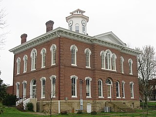
Lyon County is a county located in the U.S. state of Kentucky. As of the 2020 census, the population was 8,680. Its county seat is Eddyville. The county was formed from Caldwell County, Kentucky in 1854 and named for former Congressman Chittenden Lyon.

<span class="mw-page-title-main">Livingston County, Kentucky</span> County in Kentucky, United States

Livingston County is a county located in the U.S. state of Kentucky. As of the 2020 census, the population was 8,888. Its county seat is Smithland and its largest community is Ledbetter. The county was established in 1798 from land taken from Christian County and is named for Robert R. Livingston, a member of the Committee of Five that drafted the U.S. Declaration of Independence. The county was strongly pro-Confederate during the American Civil War and many men volunteered for the Confederate Army. Livingston County is part of the Paducah, KY-IL Metropolitan Statistical Area. It is a prohibition or dry county with the exception of Grand Rivers which voted to allow alcohol sales in 2016.

<span class="mw-page-title-main">Leslie County, Kentucky</span> County in Kentucky, United States

Leslie County is located in the U.S. state of Kentucky. Its county seat and largest city is Hyden. As of the 2020 census, the population was 10,513. It was formed in 1878 from portions of Clay, Harlan, and Perry counties, and named for Preston Leslie, governor of Kentucky from 1871 to 1875.

<span class="mw-page-title-main">Grant County, Kentucky</span> County in Kentucky, United States

Grant County is a county located in the northern part of the U.S. state of Kentucky. As of the 2020 census, the population was 24,941. Its county seat is Williamstown. The county was formed in 1820 and named for Colonel John Grant, who led a party of settlers in 1779 to establish Grant's Station, in today's Bourbon County, Kentucky. Grant County is included in the Cincinnati-Middletown, OH-KY-IN Metropolitan Statistical Area. Grant County residents voted to allow full alcohol sales in the county by a margin of 56% to 44% in a special election on December 22, 2015. In the 19th century, Grant County had multiple saloons.

<span class="mw-page-title-main">Casey County, Kentucky</span> County in Kentucky, United States

Casey County is a county located in the U.S. Commonwealth of Kentucky. As of the 2020 census, the population was 15,941. Its county seat is Liberty. The county was formed in 1806 from the western part of Lincoln County and named for Colonel William Casey, a pioneer settler who moved his family to Kentucky in 1779. It is the only Kentucky county entirely in the Knobs region. Casey County is home to annual Casey County Apple Festival, and is a prohibition or dry county. It is considered part of the Appalachian region of Kentucky.

<span class="mw-page-title-main">Carroll County, Kentucky</span> County in Kentucky, United States

Carroll County is a county located in the northern part of the U.S. state of Kentucky. Its county seat is Carrollton. The county was formed in 1838 and named for Charles Carroll of Carrollton, the last living signer of the Declaration of Independence. It is located at the confluence of the Kentucky and Ohio Rivers.

<span class="mw-page-title-main">Boyle County, Kentucky</span> County in Kentucky, United States

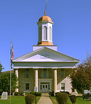
Boyle County is a county located in the central part of Kentucky. As of the 2020 census, the population was 30,614. Its county seat is Danville. The county was formed in 1842 and named for John Boyle (1774–1835), a U.S. Representative, chief justice of the Kentucky Court of Appeals, and later federal judge for the District of Kentucky, and is part of the Danville, KY Micropolitan Statistical Area.

<span class="mw-page-title-main">Marion County, Illinois</span> County in Illinois, United States

Marion County is a county located in the U.S. state of Illinois. According to the 2020 census, it had a population of 37,729. Its county seat is Salem.

<span class="mw-page-title-main">Johnson County, Illinois</span> County in Illinois, United States

Johnson County is a county in the U.S. state of Illinois. According to the 2020 census, it has a population of 13,308. Its county seat is Vienna. It is located in the southern portion of Illinois known locally as "Little Egypt".

<span class="mw-page-title-main">Hardin County, Illinois</span> County in Illinois, United States

Hardin County is a county located in the U.S. state of Illinois. According to the 2020 census, it has a population of 3,649, making it the least populous county in Illinois. Its county seat is Elizabethtown. Hardin County is located in the part of the state known as Little Egypt. Hardin County was named for Hardin County, Kentucky, which was named in honor of Colonel John Hardin, an officer in the American Revolutionary War and the Northwest Indian War.

<span class="mw-page-title-main">Gallatin County, Illinois</span> County in Illinois, United States

Gallatin County is a county located in the U.S. state of Illinois. According to the 2020 census, it has a population of 4,946, making it the third-least populous county in Illinois. Its county seat is Shawneetown. It is located in the southern portion of Illinois known locally as Little Egypt. Located at the mouth of the Wabash River, Gallatin County, along with neighboring Posey County, Indiana, and Union County, Kentucky form the tri-point of the Illinois-Indiana-Kentucky Tri-State Area.

<span class="mw-page-title-main">Crittenden County, Arkansas</span> County in Arkansas, United States

Crittenden County is a county located in the U.S. state of Arkansas. As of the 2020 census, the population was 48,163. The county seat is Marion, and the largest city is West Memphis.

<span class="mw-page-title-main">Marion, Kentucky</span> City in Kentucky, United States

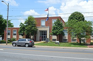
Marion is a home rule-class city in Crittenden County, Kentucky, in the United States. It is the seat of its county. As of the 2010 census, the city population was 3,039.

References

  1. "Census - Geography Profile: Crittenden County, Kentucky". United States Census Bureau . Retrieved December 30, 2022.
  2. "Find a County". National Association of Counties. Archived from the original on May 31, 2011. Retrieved June 7, 2011.
  3. The Register of the Kentucky State Historical Society, Volume 1. Kentucky State Historical Society. 1903. pp.  35.
  4. Gannett, Henry (1905). The Origin of Certain Place Names in the United States. Govt. Print. Off. pp.  96.
  5. 1 2 Kleber, John E., ed. 1992, The Kentucky Encyclopedia. The University Press of Kentucky, Lexington.
  6. Hill, William 2014 "Phase I Archaeological Survey for the Planned Perry and Lisa Jones Wetland Reserve Enhancement Project, Crittenden County, Kentucky" Corn Island Archaeology, LLC. Louisville KY.
  7. "2010 Census Gazetteer Files". United States Census Bureau. August 22, 2012. Archived from the original on August 12, 2014. Retrieved August 13, 2014.
  8. "Annual Estimates of the Resident Population for Counties: April 1, 2020 to July 1, 2023". United States Census Bureau. Retrieved March 14, 2024.
  9. "U.S. Decennial Census". United States Census Bureau. Retrieved August 13, 2014.
  10. "Historical Census Browser". University of Virginia Library. Archived from the original on August 11, 2012. Retrieved August 13, 2014.
  11. "Population of Counties by Decennial Census: 1900 to 1990". United States Census Bureau. Retrieved August 13, 2014.
  12. "Census 2000 PHC-T-4. Ranking Tables for Counties: 1990 and 2000" (PDF). United States Census Bureau. Archived (PDF) from the original on March 27, 2010. Retrieved August 13, 2014.
  13. "State & County QuickFacts". United States Census Bureau. Archived from the original on August 6, 2011. Retrieved March 6, 2014.
  14. "U.S. Census website". United States Census Bureau . Retrieved January 31, 2008.
  15. Copeland, James E.; ‘Where Were the Kentucky Unionists and Secessionists’; The Register of the Kentucky Historical Society, volume 71, no. 4 (October, 1973), pp. 344-363
  16. Leip, David. "Dave Leip's Atlas of U.S. Presidential Elections". uselectionatlas.org. Retrieved July 1, 2018.
  17. Dave Leip’s U.S. Election Atlas; 1979 Gubernatorial General Election Results – Kentucky
  18. Dave Leip’s U.S. Election Atlas; 1995 Gubernatorial General Election Results – Kentucky