Wayne County, Kentucky

Last updated

Wayne County
Wayne County Kentucky courthouse.jpg
Wayne County courthouse in Monticello
Map of Kentucky highlighting Wayne County.svg
Location within the U.S. state of Kentucky
Kentucky in United States.svg
Kentucky's location within the U.S.
Coordinates: 36°49′N84°50′W / 36.81°N 84.83°W / 36.81; -84.83
CountryFlag of the United States.svg United States
StateFlag of Kentucky.svg  Kentucky
FoundedDecember 13, 1800
Named for Anthony Wayne
Seat Monticello
Largest cityMonticello
Area
  Total484 sq mi (1,250 km2)
  Land458 sq mi (1,190 km2)
  Water26 sq mi (70 km2)  5.4%
Population
 (2020)
  Total19,555
  Estimate 
(2023)
19,580 Increase2.svg
  Density40/sq mi (16/km2)
Time zone UTC−5 (Eastern)
  Summer (DST) UTC−4 (EDT)
Congressional district 5th
Website waynecounty.ky.gov/Pages/default.aspx

Wayne County is a county in the U.S. state of Kentucky along the southern border with Tennessee. As of the 2020 census, the population was 19,555. [1] Its county seat is Monticello. [2] The county, on the south-central border with Tennessee, was named for Gen. Anthony Wayne, a Revolutionary War hero. As of November 3, 2020, Wayne County is a wet county a measure allowing the sales and consumption of alcoholic drinks passed by a margin of 4,901 for and 3,966 against. [3]

Contents

History

The first known European-American settlers to visit the area were longhunters who arrived in the 1770s. They established a temporary camp near Mill Springs on the Cumberland River. Benjamin Price built a log cabin in 1775, and Price's Station became one of the earliest Kentucky settlements. [4] This was still an area of Cherokee homeland territory, and conflicts arose between the groups as more Americans settled here.

Many Revolutionary War veterans followed Price, including Joshua Jones, who arrived in 1794, Jonathan and James Ingram in 1796, Cornelius Phillips in 1798, and Isaac West in 1799. Veterans, they had each been given land grants in the area, in lieu of back salary payments by the United States government from the war. [5]

Wayne County was formed December 13, 1800 from Pulaski and Cumberland counties. It was the 43rd county in the state and is named for General "Mad Anthony" Wayne, a hero of the American Revolution and the Northwest Indian War. [6] Wayne's victory at the Battle of Fallen Timbers virtually ended the Indian threat against Kentucky settlers. [7]

The area was developed for agriculture, and planters used enslaved African Americans as laborers. Early in the Civil War, Confederate Army General Felix Zollicoffer made his headquarters in the Brown-Lanier House at Mill Springs. He was killed at the Battle of Mill Springs on January 19, 1862, when he mistook some Union troops for his own and approached them. The Union men shot him dead, and without their leader, the Confederate were defeated. [5]

During the winter of 1861, the Confederate Government Of Kentucky issued an act to rename Wayne County to Zollicoffer County in honor of Felix Zollicoffer, who died at the Battle of Mill Springs. [8]

Geography

According to the United States Census Bureau, the county has a total area of 484 square miles (1,250 km2), of which 458 square miles (1,190 km2) is land and 26 square miles (67 km2) (5.4%) is water. [9]

The county's elevation ranges from 656 to 1,870 feet (200 to 570 m) ASL, [10] at the Monticello/Wayne County Airport the elevation is 963 feet (294 m). Wayne County is located in the Pennyrile Plateau (image) and Eastern Coal Field (image) regions of Kentucky.

Adjacent counties

National protected area

Time zone boundary

Along KY 90 Wayne Co KY.JPG
Along KY 90

Wayne County is on Eastern Time; however, its western border, shared with Clinton and Russell Counties, is part of the Eastern/Central time zone boundary, as is its southern border with Pickett County, TN. Wayne County observed Central time until October 2000; an account of this change is documented in an article by Dr. Stanley Brunn of the University of Kentucky. [11]

The county has the tz database zone identifier America/Kentucky/Monticello.

Farmland in Wayne County Wayne county ky farmland.jpg
Farmland in Wayne County

Demographics

Historical population
CensusPop.Note
1810 5,430
1820 7,95146.4%
1830 8,6859.2%
1840 7,399−14.8%
1850 8,69217.5%
1860 10,25918.0%
1870 10,6023.3%
1880 12,51218.0%
1890 12,8522.7%
1900 14,89215.9%
1910 17,51817.6%
1920 16,208−7.5%
1930 15,848−2.2%
1940 17,2048.6%
1950 16,475−4.2%
1960 14,700−10.8%
1970 14,268−2.9%
1980 17,02219.3%
1990 17,4682.6%
2000 19,92314.1%
2010 20,8134.5%
2020 19,555−6.0%
2023 (est.)19,580 [12] 0.1%
US Decennial Census [13]
1790-1960 [14] 1900-1990 [15]
1990-2000 [16] 2010-2020 [1]

As of the census of 2000, there were 19,923 people, 7,913 households, and 5,808 families in the county. The population density was 43 per square mile (17/km2). There were 9,789 housing units at an average density of 21 per square mile (8.1/km2). The racial makeup of the county was 96.98% White, 1.49% Black or African American, 0.18% Native American, 0.11% Asian, 0.47% from other races, and 0.78% from two or more races. 1.46% of the population were Hispanic or Latino any race.

There were 7,913 households, out of which 33.40% had children under the age of 18 living with them, 58.90% were married couples living together, 10.60% had a female householder with no husband present, and 26.60% were non-families. 23.90% of all households were made up of individuals, and 10.40% had someone living alone who was 65 years of age or older. The average household size was 2.49 and the average family size was 2.94.

The county population contained 25.30% under the age of 18, 8.90% from 18 to 24, 28.10% from 25 to 44, 24.00% from 45 to 64, and 13.60% who were 65 years of age or older. The median age was 37 years. For every 100 females there were 97.80 males. For every 100 females age 18 and over, there were 94.90 males.

The median income for a household in the county was $20,863, and the median income for a family was $24,869. Males had a median income of $24,021 versus $18,102 for females. The per capita income for the county was $12,601. About 24.60% of families and 29.40% of the population were below the poverty line, including 34.90% of those under age 18 and 31.50% of those over age 64.

Notable people

Historical attractions

Politics

United States presidential election results for Wayne County, Kentucky [18]
Year Republican Democratic Third party
No.%No.%No.%
2020 7,43080.41%1,70018.40%1101.19%
2016 6,37179.72%1,43117.91%1902.38%
2012 5,28973.36%1,85525.73%660.92%
2008 4,86867.65%2,20130.59%1271.76%
2004 5,02765.41%2,61634.04%420.55%
2000 4,06962.85%2,31235.71%931.44%
1996 3,12251.56%2,42240.00%5118.44%
1992 3,41252.44%2,51638.67%5798.90%
1988 3,67263.89%2,05735.79%180.31%
1984 4,44966.00%2,27733.78%150.22%
1980 3,97259.14%2,67339.80%711.06%
1976 3,24355.75%2,53743.61%370.64%
1972 3,51464.83%1,85334.19%530.98%
1968 3,05561.08%1,46729.33%4809.60%
1964 2,38946.44%2,73753.21%180.35%
1960 3,97366.92%1,96433.08%00.00%
1956 3,60961.15%2,26338.34%300.51%
1952 3,39657.94%2,46141.99%40.07%
1948 2,48054.07%2,02944.23%781.70%
1944 3,04860.12%2,02239.88%00.00%
1940 3,17755.72%2,51944.18%60.11%
1936 2,92453.36%2,54646.46%100.18%
1932 2,68247.50%2,92951.88%350.62%
1928 2,90763.89%1,63535.93%80.18%
1924 2,43654.31%2,02045.04%290.65%
1920 2,99261.70%1,82737.68%300.62%
1916 1,63853.99%1,37345.25%230.76%
1912 1,09628.83%2,16857.02%53814.15%

Communities

Education

Wayne County Schools operates the county's public schools.

On June 30, 2013 Monticello Independent Schools merged into Wayne County schools. [20]

Vocational education in the county has been provided by Wayne County Vocational School from 1971 to the present. Its name has changed several times during that period; it is presently knows as Wayne County Area Technology Center (ATC). It is managed by The Office Of Career And Technical Education. The school serves secondary students enrolled in Wayne County High School. Programs include Health Science, Welding, Carpentry, Machine Tool, Automotive, Industrial Maintenance, and Business.

See also

Related Research Articles

<span class="mw-page-title-main">Clinton County, Kentucky</span> County in Kentucky, United States

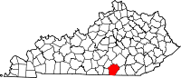
Clinton County is a county located in the U.S. state of Kentucky in the Pennyrile Region along the southern border with Tennessee. As of the 2020 census, the population was 9,253. Its county seat is Albany. The county was formed in 1835 and named for DeWitt Clinton, the seventh Governor of New York. It is a prohibition or dry county.

<span class="mw-page-title-main">McCracken County, Kentucky</span> County in Kentucky, United States

McCracken County is a county located in the far west portion of U.S. state of Kentucky. As of the 2020 census, the population was 67,875. The county seat and only municipality is Paducah. McCracken County was the 78th county formed in the state, having been created in 1825. It is part of the historic Jackson Purchase, territory sold by the Chickasaw people to General Andrew Jackson and Governor Isaac Shelby; this territory was located at the extreme western end of Kentucky.

<span class="mw-page-title-main">Wayne County, Tennessee</span> County in Tennessee, United States

Wayne County is a county located in south central Tennessee, along the Alabama border. As of the 2020 census, the population was 16,232. Its county seat is Waynesboro. The county is named after General "Mad Anthony" Wayne, a prominent military leader in the American Revolutionary War.

<span class="mw-page-title-main">Sumner County, Tennessee</span> County in Tennessee, United States

Sumner County is a county located on the central northern border of Tennessee in the United States. As of the 2020 United States Census, the population was 196,281. Its county seat is Gallatin, and its most populous city is Hendersonville. The county is named after an American Revolutionary War hero, General Jethro Sumner.

<span class="mw-page-title-main">Stewart County, Tennessee</span> County in Tennessee, United States

Stewart County is a county located on the northwestern corner of Middle Tennessee, in the U.S. state of Tennessee. As of the 2020 census, the population was 13,657. Its county seat is Dover. Stewart County is part of the Clarksville Metropolitan Statistical Area.

<span class="mw-page-title-main">Scott County, Tennessee</span> County in Tennessee, United States

Scott County is a county located in the U.S. state of Tennessee. As of the 2020 census, its population was 22,039, down from 22,228 at the 2010 census. Its county seat is Huntsville and the largest town is Oneida. Scott County is known for having seceded from Tennessee in protest of the state's decision to join the Confederacy during the Civil War, and subsequently forming The Free and Independent State of Scott.

<span class="mw-page-title-main">Roane County, Tennessee</span> County in Tennessee, United States

Roane County is a county of the U.S. state of Tennessee. As of the 2020 census, the population was 53,404. Its county seat is Kingston. Roane County is included in the Knoxville, TN Metropolitan Statistical Area.

<span class="mw-page-title-main">Taylor County, Kentucky</span> County in Kentucky, United States

Taylor County is a county located in the U.S. state of Kentucky. As of the 2020 census, the population was 26,023. Its county seat is Campbellsville. Settled by people from Virginia, Pennsylvania, Maryland, and North Carolina after the American Revolutionary War, the county was organized in 1848 in the Highland Rim region. It is named for United States Army General Zachary Taylor, later President of the United States. Taylor County was the 100th of the 120 counties created by Kentucky. The Campbellsville Micropolitan Statistical Area includes all of Taylor County.

<span class="mw-page-title-main">Russell County, Kentucky</span> County in Kentucky, United States

Russell County is a county located in the U.S. Commonwealth of Kentucky. As of the 2020 census, the population was 17,991. Its county seat is Jamestown and its largest city is Russell Springs. The county was formed on December 14, 1825, from portions of Adair, Cumberland and Wayne Counties and is named for William Russell.

<span class="mw-page-title-main">Pulaski County, Kentucky</span> County in Kentucky, United States

Pulaski County is a county in the U.S. Commonwealth of Kentucky. As of the 2020 census, the population was 65,034. Its county seat is Somerset. The county was founded in December 1798 from land given by Lincoln and Green Counties and named for Polish patriot Count Casimir Pulaski. Pulaski County comprises the Somerset, KY Micropolitan Statistical Area. Somerset's population is just over 11,000, but the Micropolitan Area for Somerset/Pulaski County is over 65,000.

<span class="mw-page-title-main">Meade County, Kentucky</span> County in Kentucky, United States

Meade County is a county located in the U.S. state of Kentucky. As of the 2020 census, the population was 30,003. Its county seat is Brandenburg. The county was founded December 17, 1823, and named for Captain James M. Meade, who was killed in action at the Battle of River Raisin during the War of 1812. Meade County is part of the Elizabethtown-Fort Knox, KY Metropolitan Statistical Area, which is included in the Louisville/Jefferson County-Elizabethtown-Madison, KY-IN Combined Statistical Area.

<span class="mw-page-title-main">LaRue County, Kentucky</span> County in Kentucky, United States

LaRue County is a county in the central region of the U.S. state of Kentucky, outside the Bluegrass Region and larger population centers. As of the 2020 census, the population was 14,867. Its county seat is Hodgenville, which is best known as the birthplace of United States President Abraham Lincoln. The county was established on March 4, 1843, from the southeast portion of Hardin County. It was named for John P. LaRue, an early settler. LaRue County is included in the Elizabethtown-Fort Knox, KY Metropolitan Statistical Area, which is also included in the Louisville/Jefferson County-Elizabethtown-Bardstown, KY-IN Combined Statistical Area. It is a dry county.

<span class="mw-page-title-main">Hardin County, Kentucky</span> County in Kentucky, United States

Hardin County is a county located in the central part of the U.S. state of Kentucky. Its county seat is Elizabethtown. The county was formed in 1792. Hardin County is part of the Elizabethtown-Fort Knox, KY Metropolitan Statistical Area, as well as the Louisville/Jefferson County—Elizabethtown-Bardstown, KY-IN Combined Statistical Area. As of the 2020 census, the population was 110,702.

<span class="mw-page-title-main">Christian County, Kentucky</span> County in Kentucky, United States

Christian County is a county located in the U.S. state of Kentucky. As of the 2020 census, the population was 72,748. Its county seat is Hopkinsville. The county was formed in 1797. Christian County is part of the Clarksville, Tennessee–Kentucky Metropolitan Statistical Area.

<span class="mw-page-title-main">Casey County, Kentucky</span> County in Kentucky, United States

Casey County is a county located in the U.S. Commonwealth of Kentucky. As of the 2020 census, the population was 15,941. Its county seat is Liberty. The county was formed in 1806 from the western part of Lincoln County and named for Colonel William Casey, a pioneer settler who moved his family to Kentucky in 1779. It is the only Kentucky county entirely in the Knobs region. Casey County is home to annual Casey County Apple Festival, and is a prohibition or dry county. It is considered part of the Appalachian region of Kentucky.

<span class="mw-page-title-main">Drew County, Arkansas</span> County in Arkansas, United States

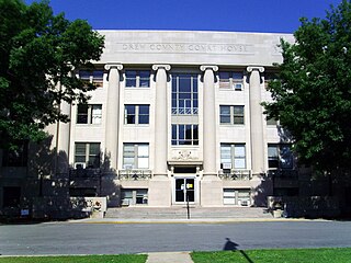
Drew County is a county located in the southeast region of the U.S. state of Arkansas. As of the 2020 census, the population was 17,350. The county seat and largest city is Monticello. Drew County was formed on November 26, 1846, and named for Thomas Drew, the third governor of Arkansas.

<span class="mw-page-title-main">Shepherdsville, Kentucky</span> City in Kentucky, United States

Shepherdsville is a home rule-class city on the Salt River in Bullitt County, Kentucky, in the United States. It is the second largest city and seat of its county, located just south of Louisville. The population was 14,201 during the 2020 U.S. Census.

<span class="mw-page-title-main">Taylor Mill, Kentucky</span> City in Kentucky, United States

Taylor Mill is a home rule-class city in Kenton County, Kentucky, in the United States. The population was 6,873 at the 2020 census.

<span class="mw-page-title-main">Monticello, Kentucky</span> City in Kentucky, United States

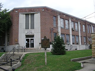
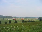
Monticello is a city in Wayne County, Kentucky, in the United States. It is the seat of its county. The population was 6,188 at the time of the 2010 U.S. census.

<span class="mw-page-title-main">Richfield, New York</span> Town in Otsego County, New York, US

Richfield is a town located in Otsego County, New York, United States. As of the 2010 census, the town had a population of 2,388. The Town of Richfield is located at the northern border of the county.

References

  1. 1 2 "State & County QuickFacts". United States Census Bureau. Retrieved October 24, 2022.
  2. "Find a County". National Association of Counties. Retrieved June 7, 2011.
  3. "No more out-of-town alcohol runs for Wayne County by Spring 2021". Commonwealth Journal. Retrieved December 13, 2020.
  4. "Price's Meadow", Kentucky Historical Marker #988, Wayne County, 10 miles north of Monticello on Ky Highway 90.
  5. 1 2 Kleber, John, ed. (1992). The Kentucky Encyclopedia. University of Kentucky Press. pp. 938–39. ISBN   0813117720.
  6. The Register of the Kentucky State Historical Society, Vol. 1. Kentucky State Historical Society. 1903. p.  37.
  7. Nelson, Paul David (1985). Anthony Wayne, Soldier of the Early Republic . Bloomington IN: Indiana University Press. p. 252. ISBN   0-253-30751-1.
  8. Brown, p. 89
  9. "2010 Census Gazetteer Files". US Census Bureau. August 22, 2012. Archived from the original on August 12, 2014. Retrieved August 20, 2014.
  10. AnyPlaceAmerica.com (accessed July 9, 2020)
  11. Brunn, Stanley D. 2001. "Citizen reaction to a proposed time zone change in Kentucky: Juxtaposing boundaries on the land / in the mind." Southeastern Geographer 41 (2): 246-258.
  12. "Annual Estimates of the Resident Population for Counties: April 1, 2020 to July 1, 2023". United States Census Bureau. Retrieved March 14, 2024.
  13. "US Decennial Census". US Census Bureau. Retrieved August 20, 2014.
  14. "Historical Census Browser". University of Virginia Library. Retrieved August 20, 2014.
  15. "Population of Counties by Decennial Census: 1900 to 1990". US Census Bureau. Retrieved August 20, 2014.
  16. "Census 2000 PHC-T-4. Ranking Tables for Counties: 1990 and 2000" (PDF). US Census Bureau. Archived (PDF) from the original on March 27, 2010. Retrieved August 20, 2014.
  17. "Mrs. Bryan's "Kentucky Housewife": Managing a Household in the 1830s". Primary Source Bazaar. July 18, 2019.
  18. Leip, David. "Atlas of US Presidential Elections". uselectionatlas.org.
  19. Steubenville KY (Google Maps, accessed July 9, 2020)
  20. McGinnis, Sylvia (March 19, 2013). "Monticello Independent School Operation of school district to cease June 30". Wayne County Outlook. CNHI . Retrieved October 25, 2019.

36°49′N84°50′W / 36.81°N 84.83°W / 36.81; -84.83