Monticello claims to be "The Houseboat Capital of the World" as there are numerous houseboat manufacturers in the city. The city is located along Lake Cumberland. Its economy is built on serving the recreational and tourist traffic to the lake.
Geography
According to the United States Census Bureau, the city has a total area of 6.1 square miles (16km2), all land.
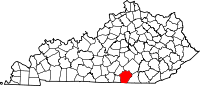
Monticello is located near the center of Wayne County, along Elk Creek, a tributary of Beaver Creek, which flows westward into Lake Cumberland.[8] State highways 92, 90, and 167, were constructed to intersect at the county seat.
History
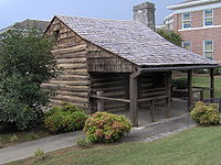
Log cabin in downtown Monticello, Kentucky, built in the early 19th century by "Raccoon" John Smith (1784–1868). The cabin was originally located in Horse Hollow on the Little South Fork River.
Monticello was designated as the county seat when the Wayne County was formed in 1800. The first Wayne County Clerk, Micah Taul, named the town after Thomas Jefferson's plantation and home, who was elected President of the United States that year.[9] Joshua Jones, a surveyor and Revolutionary War veteran, laid out the town on thirteen acres owned by William Beard. By 1810, the population numbered twenty-seven.
In the late 1800s, oil was discovered in Wayne County, creating an economic boost. Drilling began in these local oil fields in the 1880s and was renewed in 1921, and 1922.[10]
Electricity was introduced to the city in 1905. City water was installed in 1929. Manufacturing dominated the economy from the late 1950s and 1960s until the late 20th and early 21st century.[11]
In 1973, Belden Corporation (wire and cable) employed 300 people; Gamble Brothers (wood products) employed 161 people; Waterbury Garment (clothing) employed 271 people; and Monticello Manufacturing (clothing) employed 240 people. Each of these companies has left Monticello.[12]
As of the census[15] of 2000, there were 5,981 people, 2,508 households, and 1,635 families residing in the city. The population density was 984.3 inhabitants per square mile (380.0/km2). There were 2,730 housing units at an average density of 449.3 per square mile (173.5/km2). The racial makeup of the city was 94.63% White, 2.42% African American, 0.40% Native American, 0.28% Asian, 1.34% from other races, and 0.92% from two or more races. Hispanic or Latino people of any race were 2.96% of the population.
There were 2,508 households, out of which 31.3% had children under the age of 18 living with them, 46.7% were married couples living together, 14.9% had a female householder with no husband present, and 34.8% were non-families. 31.7% of all households were made up of individuals, and 16.0% had someone living alone who was 65 years of age or older. The average household size was 2.33 and the average family size was 2.91.
In the city, the population was spread out, with 25.0% under the age of 18, 9.7% from 18 to 24, 25.9% from 25 to 44, 21.9% from 45 to 64, and 17.4% who were 65 years of age or older. The median age was 36 years. For every 100 females, there were 88.9 males. For every 100 females age 18 and over, there were 84.5 males.
The median income for a household in the city was $17,423, and the median income for a family was $24,460. Males had a median income of $28,638 versus $19,259 for females. The per capita income for the city was $11,855. About 29.2% of families and 34.1% of the population were below the poverty line, including 39.9% of those under age 18 and 35.4% of those age 65 or over.
The first recorded school in Wayne County was opened about 1800 by Robert Ferrill, a well-educated wheelwright who had a few good books. Monticello's first school was opened in 1807 by Rodes Garth, who taught "Roman history, the Scriptures, orthography, and pronunciation." In 1819, Yale graduate John S. Frisbie began a school with Michael Huffaker as the first teacher of record. The Monticello Academy was established in 1830 with John Lankford as the headmaster, followed by Professor Mullins, and later William Burton.
In 1843, under the guidance of Commissioners Micajah Phillips, John Rousseau, Martin Beaty, and Francis Goddard, the county voted and ratified to organize into common school districts.
The first examiners for receiving a teaching certificate were physician Jonathan S. Frisbie, lawyer John Lankford, and teacher Littleton Beard.
By 1842 there were 16 school houses in Wayne County, three listed within several miles of Monticello.
Teachers at these schools before the Civil War include Amanda McGee, William and Thomas Simpson, Joseph Ballou, and Marcellus Baugh.
In these early schools, textbooks were scarce, but included Dilworth's Spelling Book, Murray's English Reader and English Grammar, Noble Butler's Goodrich Readers and Grammar, and the McGuffey's Readers.
The first school superintendent of Wayne County was Robert McBeath, a "member of a family noted for their intellectual qualities." His son, Tom McBeath, moved on to be President of Florida State University.
In 1866, following the Civil War, the Kendrick Academy opened in Monticello with Milton Elliott as principal.[17] Teachers in Monticello in the 1860s and 70s include Marion Huffaker, Marshall Stone, and Ala Shearer. Ones in the 1880s and 90s include Lucy and Amanda Taylor, Sallie and Eula Kendrick, Emma Kelley, Fount Cooper, William Sandusky, Tobias Huffaker, and Mollie Denny, who became the Wayne county superintendent. In 1872, the Kendrick Academy closed due to a fire.[17]
In 1879, a girls' school was opened by Roxie Buchanan, followed by William Bradshaw, and in 1885 W.T. Chaffin opened Classical High School with teachers T. Leigh Thompson, T. C. Job, and Georgia Brock; and in about 1890 added kindergarten and primary schools with teachers Ms. Oakley and Graves. Successive principals at the school up until the close of the nineteenth century were W. T. Chafin, T. Leigh Thompson, Professor H. C. Jones, Hayden Grubbs, Professor Chafin again, and finally Mr. Ballard.[18]
From 1905 until 2013 Monticello had Monticello Independent Schools, its own school district independent of the surrounding Wayne County Schools.[19]
Vocational education
Wayne County Vocational School has served students of Wayne County since 1971. The school has had many name changes over the years and is currently named Wayne County Area Technology Center (ATC). Wayne County ATC is managed by the Office of Career and Technical Education. The school serves secondary students enrolled in Wayne County High School. Programs include Health Science, Welding, Carpentry, Machine Tool, Automotive, 3D Printing Technology, Industrial Maintenance and Business.
State government representatives
Max Wise of Campbellsville, Kentucky is the current Kentucky State Senator, representing District 16 which includes Wayne, Adair, Clinton, Cumberland, McCreary, Russell, and Taylor counties. The District 52 Kentucky House of Representatives seat is held by Ken Upchurch of Monticello.[20] District 52 includes Wayne County, McCreary County, and part of Pulaski County.
Clinton County is a county located in the U.S. state of Kentucky in the Pennyrile Region along the southern border with Tennessee. As of the 2020 census, the population was 9,253. Its county seat is Albany. The county was formed in 1835 and named for DeWitt Clinton, the seventh Governor of New York. It is a prohibition or dry county.
Mingo County is a county in the U.S. state of West Virginia. As of the 2020 census, the population was 23,568. Its county seat and largest city is Williamson. Created in 1895, Mingo is West Virginia's newest county, named for the historic Iroquoian Mingo people.
Scott County is a county located in the U.S. state of Tennessee. As of the 2020 census, its population was 22,039, down from 22,228 at the 2010 census. Its county seat is Huntsville and the largest town is Oneida. Scott County is known for having seceded from Tennessee in protest of the state's decision to join the Confederacy during the Civil War, and subsequently forming The Free and Independent State of Scott.
Pickett County is a county located in the U.S. state of Tennessee. As of the 2020 census, the population was 5,001, making it the least populous county in Tennessee. Its county seat is Byrdstown. The city of Byrdstown and the Kentucky town of Albany, 11 miles (18 km) to the northeast, are positioned between two Army Corps of Engineers lakes: Dale Hollow Lake, mainly in Tennessee, and Lake Cumberland, in Kentucky. The area is known as "Twin Lakes" and Byrdstown is noted as "The Gateway To Dale Hollow Lake". Every year thousands of people vacation at the many resorts situated along the lakes.
Whitley County is a county located in the southeastern part of the U.S. state of Kentucky. As of the 2020 census, the population was 36,712. Its county seat is at Williamsburg, though the largest city is Corbin, and the county's District Court sits in both cities. Whitley County is included in the London, KY Micropolitan Statistical Area.
Wayne County is a county in the U.S. state of Kentucky along the southern border with Tennessee. As of the 2020 census, the population was 19,555. Its county seat is Monticello. The county, on the south-central border with Tennessee, was named for Gen. Anthony Wayne, a Revolutionary War hero. As of November 3, 2020, Wayne County is a wet county—a measure allowing the sales and consumption of alcoholic drinks passed by a margin of 4,901 for and 3,966 against.
Scott County is a county located in the central part of the U.S. state of Kentucky. As of the 2020 census, the population was 57,155. Scott County is part of the Lexington-Fayette, Kentucky Metropolitan Statistical Area. Its county seat and largest city is Georgetown.
Pulaski County is a county in the U.S. Commonwealth of Kentucky. As of the 2020 census, the population was 65,034. Its county seat is Somerset. The county was founded in December 1798 from land given by Lincoln and Green Counties and named for Polish patriot Count Casimir Pulaski. Pulaski County comprises the Somerset, KY Micropolitan Statistical Area. Somerset's population is just over 11,000, but the Micropolitan Area for Somerset/Pulaski County is over 65,000.
Columbia is a home rule-class city just above Russell Creek in Adair County, Kentucky, United States. The population was 4,452 at the 2010 census. Columbia is the seat of its county.
Albany is a home rule-class city in Clinton County, Kentucky, in the United States. The population was 2,033 at the 2010 census. It is the county seat of Clinton County. It is located on U.S. Route 127, about 6 miles (10 km) north of the Tennessee border.
Dycusburg is an unincorporated community in Crittenden County, Kentucky, United States. The population was 26 at the 2010 census.
Benham is a home rule-class city in Harlan County, Kentucky, in the United States. The city was formally incorporated by the General Assembly in 1961. The population was 512 at the 2020 census, up from 500 at the 2010 census.
Smithland is a home rule-class city in Livingston County, Kentucky, United States, at the confluence of the Ohio and Cumberland Rivers. The population was 301 at the 2010 census, a drop from 401 in 2000. It is the county seat of Livingston County.
Pine Knot is an unincorporated community and census-designated place (CDP) in McCreary County, Kentucky, United States. The population was 1,380 at the 2020 census, down from 1,621 in 2010.
Stearns is an unincorporated community and census-designated place (CDP) in McCreary County, Kentucky, United States. The population was 1,365 at the 2020 census. It was founded by Justus Smith Stearns.
Ferguson is a home rule-class city just south of downtown Somerset in Pulaski County, Kentucky, United States. It had a population of 924 as of the 2010 census, up from 881 in 2000.
Somerset is a home rule-class city in Pulaski County, Kentucky, United States. The city population was 11,924 according to the 2020 census. It is the seat of Pulaski County.
Russell Springs is a home rule-class city in Russell County, Kentucky, in the United States. The city is the gateway to Lake Cumberland, one of the largest man-made lakes in the region, created by Wolf Creek Dam. It is the largest city in the county, having a population of 2,441 during the year 2010 U.S. Census.
Brookville is a small city in northwestern Montgomery County, Ohio, United States. It is a suburb of Dayton. The population was 5,989 at the 2020 census.
Monticello is a city in Jones County, Iowa, United States. As of the 2020 census, the city population was 4,040.
References
↑ Commonwealth of Kentucky. Office of the Secretary of State. Land Office. "Monticello, Kentucky". Accessed 26 August 2013.
↑ "Find a County". National Association of Counties. Retrieved June 7, 2011.
↑ Kleber, John E.; Wymer, Scott A.; Kmetz, Thomas P. (January 1, 2000). The Kentucky encyclopedia. Institute for Regional Analysis and Public Policy. OCLC47829819.
This page is based on this Wikipedia article Text is available under the CC BY-SA 4.0 license; additional terms may apply. Images, videos and audio are available under their respective licenses.