Jackson, Kentucky

Last updated

Jackson, Kentucky
Breathitt County Kentucky Courthouse.jpg
Breathitt County Courthouse in Jackson
Breathitt County Kentucky Incorporated and Unincorporated areas Jackson Highlighted 2139952.svg
Location of Jackson in Breathitt County, Kentucky.
Coordinates: 37°33′11″N83°23′18″W / 37.55306°N 83.38833°W / 37.55306; -83.38833
CountryUnited States
State Kentucky
County Breathitt
Established1839
Incorporated1845
Reïncorporated1890
Named for Pres. Andrew Jackson
Area
[1]
  Total2.67 sq mi (6.92 km2)
  Land2.51 sq mi (6.50 km2)
  Water0.16 sq mi (0.42 km2)
Elevation
774 ft (236 m)
Population
 (2020)
  Total2,237
  Estimate 
(2022) [2]
2,157
  Density891.95/sq mi (344.32/km2)
Time zone UTC−5 (Eastern (EST))
  Summer (DST) UTC−4 (EDT)
ZIP codes
41307, 41339
Area code 606
FIPS code 21-39952
GNIS feature ID0495097

Jackson is a home rule-class city [3] in and the county seat of Breathitt County, Kentucky, in the United States. The population was 2,231 according to the 2010 U.S. census. [4]

Contents

It was the home of the Jackson Academy, which became Lees College.

History

Upon the creation of Breathitt County in 1839, local landowner Simon Cockrell Sr. donated 10 acres (4.0 ha) to serve as its seat of government. The community was originally known as Breathitt, Breathitt Town, or Breathitt Court House after the county, but upon its incorporation as a city by the state legislature in 1843, [5] it was renamed Jackson to honor former president Andrew Jackson. [6] [7]

Local feuds led the national press to publish stories about Jackson and "Bloody Breathitt": state troops were dispatched twice in the 1870s and again in 1903 after the assassination of U.S. Commissioner James B. Marcum on the courthouse steps [8] to restore order. [7]

The Kentucky Union Railroad reached the city in 1891, and Jackson boomed until the L&N continued the line on to Hazard in 1912. A fire on Halloween, 1913, burned down much of the town. [7]

Geography

Jackson is located at 37°33′11″N83°23′18″W / 37.55306°N 83.38833°W / 37.55306; -83.38833 (37.553012, 83.388249). [9] The city is nestled in the heart of the Cumberland Plateau of the Appalachian Mountains, with the downtown located on the north bank of the North Fork of the Kentucky River. To limit flooding, the Kentucky River was redirected in 1963 by way of a small cut-through through the mountain, and its former channel, a river meander, was left behind as Panbowl Lake, now a prime attraction for fishermen. [7]

According to the United States Census Bureau, Jackson has a total area of 2.7 square miles (6.9 km2), of which 2.5 square miles (6.5 km2) is land and 0.15 square miles (0.4 km2), or 6.11%, is water. [4]

Climate

The climate in this area is characterized by relatively moderate temperatures and evenly distributed precipitation throughout the year. The Köppen climate classification places the city in the humid subtropical zone, which is abbreviated as Cfa. [10] The normal monthly mean temperature ranges from 34.9 °F (1.6 °C) in January to 75.4 °F (24.1 °C) in July. On average, there are 17 days where temperatures remain at or below freezing and 15 days with highs at or above 90 °F (32 °C) per year. In addition, although the area falls under USDA hardiness zone 6b, [11] the record longest streak without 0 °F (−18 °C) lows occurred from February 6, 1996, to January 15, 2009 (12 years, 344 days). [12] The highest recorded temperature was 104 °F (40 °C) on June 29, 2012, and the lowest recorded temperature was −18 °F (−28 °C) on January 19, 1994, and January 20 and 21, 1985. [12]

Precipitation averages 48.3 inches (1,230 mm) annually, falling on an average 144 days, and the wettest month by normal rainfall is May. [13] Normal winter snowfall is 23.5 inches (60 cm), [13] though, as is typical in areas in the humid subtropical zone, snow cover does not remain for long, as there is an average of only 18 days with at least 1 inch (2.5 cm) of snow cover. [13]

Climate data for Jackson, Kentucky (Julian Carroll Airport, 1,381 ft or 421 m AMSL, 37°35′29″N83°18′52″W / 37.59139°N 83.31444°W / 37.59139; -83.31444 ), 1991–2020 normals, extremes 1981–present
MonthJanFebMarAprMayJunJulAugSepOctNovDecYear
Record high °F (°C)78
(26)
80
(27)
87
(31)
92
(33)
91
(33)
104
(40)
101
(38)
101
(38)
98
(37)
97
(36)
84
(29)
79
(26)
104
(40)
Mean daily maximum °F (°C)44.2
(6.8)
48.8
(9.3)
58.0
(14.4)
69.2
(20.7)
75.7
(24.3)
82.2
(27.9)
85.0
(29.4)
84.4
(29.1)
79.0
(26.1)
68.8
(20.4)
57.4
(14.1)
47.6
(8.7)
66.7
(19.3)
Daily mean °F (°C)35.8
(2.1)
39.7
(4.3)
47.8
(8.8)
58.2
(14.6)
65.6
(18.7)
72.6
(22.6)
75.7
(24.3)
74.9
(23.8)
69.1
(20.6)
58.7
(14.8)
48.1
(8.9)
39.7
(4.3)
57.2
(14.0)
Mean daily minimum °F (°C)27.4
(−2.6)
30.5
(−0.8)
37.6
(3.1)
47.3
(8.5)
55.6
(13.1)
62.9
(17.2)
66.5
(19.2)
65.3
(18.5)
59.1
(15.1)
48.5
(9.2)
38.8
(3.8)
31.8
(−0.1)
47.6
(8.7)
Record low °F (°C)−18
(−28)
−8
(−22)
7
(−14)
20
(−7)
30
(−1)
44
(7)
52
(11)
45
(7)
34
(1)
26
(−3)
13
(−11)
−13
(−25)
−18
(−28)
Average precipitation inches (mm)3.96
(101)
4.06
(103)
4.71
(120)
4.54
(115)
5.17
(131)
5.25
(133)
5.10
(130)
4.26
(108)
3.42
(87)
3.45
(88)
3.50
(89)
4.47
(114)
51.89
(1,318)
Average snowfall inches (cm)7.4
(19)
6.7
(17)
4.0
(10)
0.4
(1.0)
0.0
(0.0)
0.0
(0.0)
0.0
(0.0)
0.0
(0.0)
0.0
(0.0)
0.1
(0.25)
0.7
(1.8)
4.1
(10)
23.4
(59)
Average precipitation days (≥ 0.01 in)14.413.814.413.213.812.712.610.58.29.511.013.9148.0
Average snowy days (≥ 0.1 in)6.35.63.30.50.00.00.00.00.00.11.14.721.6
Source: NOAA [12] [13]

Demographics

Historical population
CensusPop.Note
1870 54
1880 8863.0%
1900 941
1910 1,34643.0%
1920 1,50311.7%
1930 2,10940.3%
1940 2,099−0.5%
1950 1,978−5.8%
1960 1,852−6.4%
1970 1,8871.9%
1980 2,65140.5%
1990 2,466−7.0%
2000 2,4901.0%
2010 2,231−10.4%
2020 2,2370.3%
2022 (est.)2,157 [14] −3.6%
U.S. Decennial Census [15]

As of 2020, Jackson, KY had a population of 2.2k people with a median age of 42 and a median household income of $32,644. Between 2019 and 2020 the population of Jackson, KY grew from 2,106 to 2,201, a 4.51% increase and its median household income grew from $30,898 to $32,644, a 5.65% increase.

The 5 largest ethnic groups in Jackson, KY are White (Non-Hispanic) (98.9%), Asian (Non-Hispanic) (1.04%), White (Hispanic) (0.0454%), Black or African American (Non-Hispanic) (0%), and Black or African American (Hispanic) (0%). [16]

Transportation

Kentucky Routes within the city

Airports

Railroads

Education

Oakdale Christian Academy

https://oakdalechristian.org/

Jackson Independent Schools

Breathitt County Schools

Vocational

Post-secondary

Educational Centers

Festivals

The city of Jackson and Breathitt County are host to many local festivals.

In Jackson:

Other festivals that occur outside the city but in Breathitt County:

Notable people

Related Research Articles

<span class="mw-page-title-main">Lee County, Kentucky</span> County in Kentucky, United States

Lee County is a county located in the U.S. state of Kentucky. As of the 2020 census, the population was 7,395. Its county seat is Beattyville. The county was formed in 1870 from parts of Breathitt, Estill, Owsley and Wolfe counties. The county was named for Robert E. Lee. The area of Kentucky where Lee County is located was a pro-union region of Kentucky but the legislature that created the county was controlled by former Confederates. The town of Proctor, named for the Rev. Joseph Proctor, was the first county seat. The first court was held on April 25, 1870, in the old Howerton House. The local economy at the time included coal mining, salt gathering, timber operations, and various commercial operations. It had a U.S. post office from 1843 until 1918.

<span class="mw-page-title-main">Jackson County, Kentucky</span> County in Kentucky, United States

Jackson County is located in the Commonwealth of Kentucky. As of the 2020 census, the population was 12,955. Its county seat is McKee. The county was formed in 1858 from land given by Madison, Estill, Owsley, Clay, Laurel, and Rockcastle counties. It was named for Andrew Jackson, seventh President of the United States. Jackson County became a moist county via a "local-option" referendum in the Fall of 2019 that legalized the sale of alcoholic beverages in the city of McKee.

<span class="mw-page-title-main">Breathitt County, Kentucky</span> County in Kentucky, United States

Breathitt County is a county in the eastern Appalachian portion of the U.S. state of Kentucky. As of the 2020 census, the population was 13,718. Its county seat is Jackson. The county was formed in 1839 and was named for John Breathitt, who was Governor of Kentucky from 1832 to 1834. Breathitt County was a prohibition or dry county, until a public vote in July 2016 that allowed alcohol sales.

<span class="mw-page-title-main">Pineville, Kentucky</span> City in Kentucky, United States

Pineville is a home rule-class city in Bell County, Kentucky, United States. It is the seat of its county. The population was 1,732 as of the 2010 census. It is located on a small strip of land between the Cumberland River and Pine Mountain.

<span class="mw-page-title-main">Ashland, Kentucky</span> City in Kentucky, United States

Ashland is a home rule-class city in Boyd County, Kentucky, United States. The largest city in Boyd County, Ashland is located upon a southern bank of the Ohio River at the state border with Ohio and near West Virginia. The population was 21,625 at the 2020 census. Ashland is a principal city of the Huntington–Ashland metropolitan area, referred to locally as the "Tri-State area", home to 376,155 residents as of 2020. Ashland serves as an important economic and medical center for northeastern Kentucky.

<span class="mw-page-title-main">Grayson, Kentucky</span> City in Kentucky, United States

Grayson is a home rule-class city in and the county seat of Carter County, Kentucky, United States, on U.S. Route 60 and Interstate 64 in the state's northeastern region. It is approximately 21 miles west of Ashland. Within the city limits, the population was 4,217 at the 2010 census. Along with Carter County, the city is closely associated with the nearby Huntington-Ashland, WV-KY-OH Metropolitan Statistical Area and is often erroneously included in the MSA being just 9 miles west of the M.S.A's western boundary.

<span class="mw-page-title-main">Cynthiana, Kentucky</span> City in Kentucky, United States

Cynthiana is a home rule-class city in Harrison County, Kentucky, in the United States. The population was 6,402 at the 2010 census. It is the seat of its county.

<span class="mw-page-title-main">Nicholasville, Kentucky</span> City in Kentucky, United States

Nicholasville is a home rule city in and the county seat of Jessamine County, Kentucky. The population was 31,490 during the 2020 U.S. census, making Nicholasville the 10th-largest settlement in the state.

<span class="mw-page-title-main">Paintsville, Kentucky</span> City in Kentucky, United States

Paintsville is a home rule-class city along Paint Creek in Johnson County, Kentucky, in the United States. It is the seat of its county. The population was 3,459 during the 2010 U.S. Census.

<span class="mw-page-title-main">London, Kentucky</span> City in Kentucky, United States

London is a home rule-class city in Laurel County, Kentucky, in the United States. It is the seat of its county. The population was 8,053 at the time of the 2020 census. It is the second-largest city named "London" in the United States and the fourth-largest in the world. It is part of the London, Kentucky micropolitan area. Of the seventeen micropolitan areas in Kentucky, London is the largest; the London micropolitan area's 2010 Census population was 126,368. London is also home to the annual World Chicken Festival that celebrates the life of Colonel Sanders and features the world's largest skillet.

<span class="mw-page-title-main">Beattyville, Kentucky</span> City in Kentucky, United States

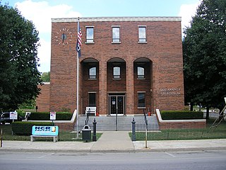
Beattyville is a home rule class city in, and the county seat of, Lee County, Kentucky, United States. The city was formally established by the state assembly as "Beatty" in 1851 and incorporated in 1872. It was named for Samuel Beatty, a pioneer settler. The population was 1,307 at the 2010 census and an estimated 1,206 in 2018.

<span class="mw-page-title-main">Whitesburg, Kentucky</span> City in Kentucky, United States

Whitesburg is a home rule-class city in and the county seat of Letcher County, Kentucky, United States. The population was 2,139 at the 2010 census and an estimated 1,875 in 2018. It was named for John D. White, a state politician.

<span class="mw-page-title-main">Russellville, Kentucky</span> City in Kentucky, United States

Russellville is a home rule-class city in Logan County, Kentucky, in the United States. It is the seat of its county. The population was 6,960 at the time of the 2010 census.

<span class="mw-page-title-main">Richmond, Kentucky</span> City in Kentucky, United States

Richmond is a home class city in KY and the county seat of Madison County, Kentucky, United States. It is named after Richmond, Virginia, and is home to Eastern Kentucky University. With close proximity to Lexington, Richmond is considered by many to be a great place to live. It has an average - high cost of living compared to other areas. The population was 36,826 as of 2023. Richmond is the fourth-largest city in the Bluegrass region and the state's seventh-largest city. It is the ninth largest population center in the state with a Micropolitan population of 106,864. The city serves as the center for work and shopping for south-central Kentucky, with many local and chain options alike. Richmond KY is home to numerous festivals, notably the Millstone Festival. In addition, Richmond is the principal city of the Richmond-Berea, Kentucky Micropolitan Area, which includes all of Madison and Rockcastle counties.

<span class="mw-page-title-main">Hazard, Kentucky</span> City in Kentucky, United States

Hazard is a home rule-class city in, and the county seat of, Perry County, Kentucky, United States. The population was 5,263 at the 2020 Census.

<span class="mw-page-title-main">Georgetown, Kentucky</span> City in Kentucky, United States

Georgetown is a home rule-class city in Scott County, Kentucky, United States. The population was 37,086 at the 2020 census. It is the 6th-largest city by population in the U.S. state of Kentucky. It is the seat of its county. It was originally called Lebanon when founded by Rev. Elijah Craig and was renamed in 1790 in honor of President George Washington. Historically, settlers were drawn to Georgetown for its Royal Spring.

<span class="mw-page-title-main">Kentucky Route 30</span> State highway in Kentucky, United States

Kentucky Route 30 is an east–west state highway in Kentucky managed by the Kentucky Transportation Cabinet.

The Kentucky Mountain Holiness Association (KMHA) is a Christian denomination in eastern Kentucky aligned with Holiness Methodist beliefs. The Association was begun in 1925 by Lela G. McConnell, a deaconess in the Methodist Episcopal Church. The Association maintains a Wesleyan-Holiness doctrine with a strong emphasis on sanctification. The association maintains an elementary school, a high school, a four-year Bible college, two radio stations, a district of churches, and a farm. Philip Speas is the current association president.

Keene is a home rule-class city located in Jessamine County, Kentucky, in the United States. It is home to the Keene Springs Hotel. The U.S. Census Bureau does not record Keene as a city and does not publish a population figure for the community.

<span class="mw-page-title-main">Kentucky Route 205</span> State highway in Kentucky, United States

Kentucky Route 205 (KY 205) is a 29-mile-long (47 km) state highway in the U.S. state of Kentucky. The highway connects mostly rural areas of Breathitt, Wolfe, and Morgan counties with Jackson, Vancleve, and Helechawa.

References

  1. "2020 U.S. Gazetteer Files". United States Census Bureau. Retrieved March 18, 2022.
  2. "Annual Estimates of the Resident Population for Incorporated Places in Kentucky: April 1, 2020 to July 1, 2022". United States Census Bureau. Retrieved May 26, 2023.
  3. "Summary and Reference Guide to House Bill 331 City Classification Reform" (PDF). Kentucky League of Cities. Retrieved December 30, 2014.
  4. 1 2 "Geographic Identifiers: 2010 Demographic Profile Data (G001): Jackson city, Kentucky". U.S. Census Bureau, American Factfinder. Archived from the original on February 12, 2020. Retrieved November 22, 2013.
  5. Commonwealth of Kentucky. Office of the Secretary of State. Land Office. "Jackson, Kentucky". Accessed 1 August 2013.
  6. Rennick, Robert. Kentucky Place Names, p. 151. University Press of Kentucky (Lexington), 1987. Accessed 1 August 2013.
  7. 1 2 3 4 The Kentucky Encyclopedia, p. 459. "Jackson". University Press of Kentucky (Lexington), 1992. Accessed 1 August 2013.
  8. "ShotDown". breathittcounty.com. Archived from the original on May 12, 2019. Retrieved April 13, 2017.
  9. "US Gazetteer files: 2010, 2000, and 1990". United States Census Bureau. February 12, 2011. Retrieved April 23, 2011.
  10. "Jackson, Kentucky Köppen Climate Classification (Weatherbase)". weatherbase.com. Retrieved April 13, 2017.
  11. United States Department of Agriculture. "USDA Plant Hardiness Zone Map". United States National Arboretum. Archived from the original on March 3, 2015. Retrieved February 19, 2015.
  12. 1 2 3 "NowData - NOAA Online Weather Data". National Oceanic and Atmospheric Administration. Retrieved June 13, 2021.
  13. 1 2 3 4 "Station: Jackson, KY". U.S. Climate Normals 2020: U.S. Monthly Climate Normals (1991–2020). National Oceanic and Atmospheric Administration. Retrieved June 13, 2021.
  14. "Annual Estimates of the Resident Population for Incorporated Places in Kentucky: April 1, 2020 to July 1, 2022". United States Census Bureau. Retrieved May 26, 2023.
  15. "Census of Population and Housing". Census.gov. Retrieved June 4, 2015.
  16. "Jackson, KY | Data USA".
  17. "Kentucky Public Library Directory". Kentucky Department for Libraries and Archives. Archived from the original on January 11, 2019. Retrieved June 5, 2019.
  18. "Festivals and Fairs". breathittcounty.org. Retrieved April 13, 2017.
  19. Hesterberg, Tanner. "Vandalism partly to blame for cancellation of Crockettsville concert, trail ride". WYMT. Retrieved April 13, 2017.
  20. Shawn Donnan, "Lunch with the FT," Financial Times, 3-4 Feb. 2018, Life and Arts p. 3
  21. Brandon Kiser, "Author Too Removed from Culture He Criticizes," Lexington Herald-Leader, Aug. 21, 2016, http://www.kentucky.com/opinion/op-ed/article96779312.html (accessed 10 Feb. 2018)
    • The paternal grandfather of Marie Guion-Johnson, PhD, founder of AUM Cardiovascular and serial medical device inventor was from Breathitt