Buckhorn, Kentucky

Last updated

Buckhorn, Kentucky
Buckhorn-Log-Cathedral-ky.jpg
Perry County Kentucky Incorporated and Unincorporated areas Buckhorn Highlighted 2110612.svg
Location of Buckhorn in Perry County, Kentucky.
Coordinates: 37°20′45″N83°28′16″W / 37.34583°N 83.47111°W / 37.34583; -83.47111
Country United States
State Kentucky
County Perry
IncorporatedJanuary 12, 1996
Government
  Type City Commission
  MayorPaul R. Turner
Area
[1]
  Total0.35 sq mi (0.91 km2)
  Land0.34 sq mi (0.87 km2)
  Water0.01 sq mi (0.04 km2)
Elevation
755 ft (230 m)
Population
 (2020)
  Total89
  Density264.09/sq mi (101.91/km2)
Time zone UTC-5 (Eastern (EST))
  Summer (DST) UTC-4 (EDT)
ZIP code
41721
Area code 606
FIPS code 21-10612
GNIS feature ID0511025

Buckhorn is a home rule-class city in Perry County, Kentucky, in the United States. The population was 162 at the 2010 census. It is centered on the Buckhorn Presbyterian Church, a log structure listed on the National Register of Historic Places. The Buckhorn Children's Center and Buckhorn Lake State Resort Park are also located here.

Contents

The post office was established in 1902. [2] Buckhorn was incorporated by the state legislature in 1996. [3]

History

According to local tradition, the name "Buckhorn" comes from an early settler, Jerry Smith, who had killed a large deer and had hung its antlers over an area spring. The name of the stream that flows through the area, Squabble Creek, is believed to have been named after a fight between Smith and his brothers. [2]

Geography

Buckhorn is located at 37°20′45″N83°28′16″W / 37.34583°N 83.47111°W / 37.34583; -83.47111 (37.345879, -83.471060). [4] The city lies in a broad valley along the Middle Fork of the Kentucky River and its tributary, Squabble Creek. Buckhorn Dam and its impoundment, Buckhorn Lake are located a short distance downstream on the river. Kentucky Route 28 passes through the city.

According to the United States Census Bureau, the city has a total area of 0.5 square miles (1.3 km2), all land.

Demographics

Historical population
CensusPop.Note
2000 144
2010 16212.5%
2020 89−45.1%
U.S. Decennial Census [5]

At the 2000 census there were 144 people, 48 households, and 33 families living in the city. The population density was 289.4 inhabitants per square mile (111.7/km2). There were 51 housing units at an average density of 102.5 per square mile (39.6/km2). The racial makeup of the city was 97.92% White and 2.08% African American. [6] Of the 48 households 29.2% had children under the age of 18 living with them, 60.4% were married couples living together, 8.3% had a female householder with no husband present, and 31.3% were non-families. 31.3% of households were one person and 16.7% were one person aged 65 or older. The average household size was 2.38 and the average family size was 2.97.

The age distribution was 34.7% under the age of 18, 9.0% from 18 to 24, 27.8% from 25 to 44, 18.1% from 45 to 64, and 10.4% 65 or older. The median age was 30 years. For every 100 females, there were 100.0 males. For every 100 females age 18 and over, there were 108.9 males.

The median household income was $35,000 and the median family income was $51,250. Males had a median income of $26,250 versus $33,750 for females. The per capita income for the city was $13,742. There were 10.0% of families and 34.2% of the population living below the poverty line, including 5.9% of under eighteens and 55.6% of those over 64.

Related Research Articles

<span class="mw-page-title-main">Powell County, Kentucky</span> County in Kentucky, United States

Powell County is a county located in the U.S. Commonwealth of Kentucky. As of the 2020 census, the population was 13,129. Its county seat is Stanton. The county was formed January 7, 1852, by Kentucky Governor Lazarus W. Powell from parts of Clark, Estill, and Montgomery counties. It is no longer a dry county as of 2018. Powell County is home to Natural Bridge State Resort Park and the Red River Gorge Geologic Area, two of Kentucky's most important natural areas and ecotourism destinations, as well as the Pilot Knob State Nature Preserve.

<span class="mw-page-title-main">Perry County, Kentucky</span> County in Kentucky, United States

Perry County is a county in the U.S. state of Kentucky. As of the 2020 census, the population was 28,473. Its county seat is Hazard. The county was founded in 1820. Both the county and county seat are named for Commodore Oliver Hazard Perry, a naval hero in the War of 1812.

<span class="mw-page-title-main">Morgan County, Kentucky</span> County in Kentucky, United States

Morgan County is a county located in the U.S. state of Kentucky. As of the 2020 census, the population was 13,726. Its county seat is West Liberty. The county is among the dry counties, which means that the sale of alcohol is restricted or prohibited.

<span class="mw-page-title-main">Ty Ty, Georgia</span> City in Georgia, United States

Ty Ty is a city in Tift County, Georgia, United States. The population was 725 at the 2010 census. The community takes its name from nearby Ty Ty Creek.

<span class="mw-page-title-main">Rosiclare, Illinois</span> City in Illinois, United States

Rosiclare is a city in Hardin County, Illinois, along the Ohio River. The population was 1,160 at the 2010 census, down from 1,213 at the 2000 census.

<span class="mw-page-title-main">Irvine, Kentucky</span> City in Kentucky, United States

Irvine is a home rule-class city in Estill County, Kentucky, in the United States. It is the seat of its county. Its population was 2,715 at the time of the 2010 census.

<span class="mw-page-title-main">Vine Grove, Kentucky</span> City in Kentucky, United States

Vine Grove is a home rule-class city in Hardin County, Kentucky, United States. The population was 4,520 at the 2010 census, up from 4,169 at the 2000 census. It is part of the Elizabethtown–Fort Knox Metropolitan Statistical Area.

<span class="mw-page-title-main">Loyall, Kentucky</span> City in Kentucky, United States

Loyall is a home rule-class city in Harlan County, Kentucky, in the United States. The population was 1,461 as of the 2010 census, up from 766 at the time of the 2000 census.

<span class="mw-page-title-main">Brownsboro Village, Kentucky</span> City in Kentucky, United States

Brownsboro Village is a home rule-class city in Jefferson County, Kentucky, United States. The population was 319 at the 2010 census.

<span class="mw-page-title-main">Cambridge, Kentucky</span> City in Kentucky, United States

Cambridge is a home rule-class city in Jefferson County, Kentucky, United States. The population was 175 at the 2010 census.

<span class="mw-page-title-main">Hills and Dales, Kentucky</span> City in Kentucky, United States

Hills and Dales is a home rule-class city in Jefferson County, Kentucky, United States. The population was 142 at the 2010 census.

<span class="mw-page-title-main">Hollyvilla, Kentucky</span> City in Kentucky, United States

Hollyvilla is a home rule-class city in Jefferson County, Kentucky, United States. The population was 537 at the 2010 census.

<span class="mw-page-title-main">Parkway Village, Kentucky</span> City in Kentucky, United States

Parkway Village is a home rule-class city in Jefferson County, Kentucky, United States, and a part of the Louisville Metro government. It was developed in the 1920s and incorporated in 1941. The population was 650 at the 2010 census.

<span class="mw-page-title-main">Windy Hills, Kentucky</span> City in Jefferson County, Kentucky, United States

Windy Hills is a home rule-class city, incorporated in 1952, in eastern Jefferson County, Kentucky, United States. The population was 2,385 at the 2010 census.

<span class="mw-page-title-main">Warfield, Kentucky</span> City in Kentucky, United States

Warfield is a home rule-class city in Martin County, Kentucky, United States. The population was 264 at the 2020 census.

<span class="mw-page-title-main">Camargo, Kentucky</span> City in Kentucky, United States

Camargo is a home rule-class city in Montgomery County, Kentucky, in the United States. The population was 1,020 at the 2020 census. It is part of the Mount Sterling Micropolitan Statistical Area.

<span class="mw-page-title-main">Jeffersonville, Kentucky</span> City in Kentucky, United States

Jeffersonville is a home rule-class city in Montgomery County, Kentucky, in the United States. The population was 1,708 as of the 2020 census, up from 1,506 in 2010. It is part of the Mount Sterling micropolitan area.

<span class="mw-page-title-main">Campton, Kentucky</span> City in Kentucky, United States

Campton is a home rule-class city in and the county seat of Wolfe County, Kentucky, United States. The population was 441 at the 2010 census.

<span class="mw-page-title-main">Osyka, Mississippi</span> Town in Mississippi, United States

Osyka is a town in Pike County, Mississippi, United States. It is located on the Mississippi–Louisiana state line. The population was 440 at the 2010 census. It is part of the McComb, Mississippi Micropolitan Statistical Area. The peak of its population was in 1910.

<span class="mw-page-title-main">Clay City, Kentucky</span> City in Kentucky, United States

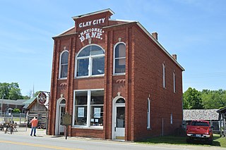
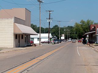
Clay City is a home rule-class city in Powell County, Kentucky, United States. The population was 1,077 at the 2010 census.

References

  1. "2020 U.S. Gazetteer Files". United States Census Bureau. Retrieved March 18, 2022.
  2. 1 2 Rennick, Robert M. Kentucky Place Names . The University Press of Kentucky (Lexington), 1988. ISBN   0-8131-0179-4.
  3. Commonwealth of Kentucky. Office of the Secretary of State: Land Office. "Buckhorn Archived February 19, 2014, at the Wayback Machine ". Accessed 14 July 2013.
  4. "US Gazetteer files: 2010, 2000, and 1990". United States Census Bureau. February 12, 2011. Retrieved April 23, 2011.
  5. "Census of Population and Housing". Census.gov. Retrieved June 4, 2015.
  6. "U.S. Census website". United States Census Bureau . Retrieved January 31, 2008.