Florence, Kentucky

Last updated

Florence, Kentucky
Florence Hotel, Florence Kentucky.JPG
Florence Hotel
Flag of Florence, Kentucky.png
Logo of Florence, Kentucky.png
Boone County Kentucky Incorporated and Unincorporated areas Florence Highlighted 2127982.svg
Location of Florence in Boone County, Kentucky.
Coordinates: 38°59′29″N84°38′46″W / 38.99139°N 84.64611°W / 38.99139; -84.64611
CountryUnited States
State Kentucky
County Boone
Established1830
IncorporatedFebruary 17, 1860
Government
  Type Mayor–council [1]
   Mayor Julie Metzger Aubuchon [2]
Area
[3]
  Total10.73 sq mi (27.78 km2)
  Land10.70 sq mi (27.72 km2)
  Water0.03 sq mi (0.07 km2)
Elevation
[4]
883 ft (269 m)
Population
 (2020)
  Total31,946
  Estimate 
(2022) [5]
32,618
  Density2,985.05/sq mi (1,152.58/km2)
Time zone UTC−5 (Eastern (EST))
  Summer (DST) UTC−4 (EDT)
ZIP codes
41022, 41042
Area code 859
FIPS code 21-27982
GNIS feature ID2403620 [4]
Website www.florence-ky.gov

Florence is a city in Boone County, Kentucky, United States, [6] part of the Cincinnati metropolitan area. The population was 31,946 at the 2020 census, [7] making it the second-largest city in Northern Kentucky, the eighth-largest city in Kentucky and the state's largest that is not a county seat. Like all but the state's two largest cities, Florence is a home rule-class city under Kentucky state law.

Contents

History

The Florence area was originally known as Crossroads, because of the convergence of several roads from Burlington and Union at Ridge Road (now U.S. 25). By 1821, the area was known as Maddentown for Thomas Madden, a Covington attorney who owned a farm on the Burlington Pike. When Madden moved away, the area became known as Connersville in 1828 for Jacob Conner, a settler who assumed responsibility for the growing town. The town was finally renamed Florence because there was another Connersville in Harrison County. The name presumably is for Florence, Italy, but the specific etymology is unclear. [8] [9] It was incorporated on January 27, 1830, and grew quickly after the completion of the Covington-Lexington Turnpike in 1836. [10] Florence was also known as Stringtown at some point earlier than 1900. [8]

Geography

Florence is located in eastern Boone County. U.S. Routes 25, 42, and 127 pass through the center of Florence, leading northeast in a concurrency 11 miles (18 km) to downtown Cincinnati. Interstates 75 and 71 pass through the western part of Florence, with access from exits 178 through 182.

According to the United States Census Bureau, the city has a total area of 10.3 square miles (26.8 km2), of which 10.3 square miles (26.7 km2) is land and 0.04 square miles (0.1 km2), or 0.43%, is water. [11]

Demographics

Historical population
CensusPop.Note
1830 62
1850 251
1870 374
1880 309−17.4%
1900 258
1910 250−3.1%
1920 2687.2%
1930 45067.9%
1940 77672.4%
1950 1,32570.7%
1960 5,837340.5%
1970 11,66199.8%
1980 15,58633.7%
1990 18,62419.5%
2000 23,55126.5%
2010 29,95127.2%
2020 31,9466.7%
2023 (est.)34,510 [12] 8.0%
U.S. Decennial Census [13] [7]

As of the census [14] of 2000, there were 23,551 people, 9,640 households, and 6,073 families residing in the city. The population density was 2,385.6 per square mile (921.1/km2). There were 10,322 housing units at an average density of 1,045.6 per square mile (403.7/km2). Today the racial makeup of the city is 79.9% White, 7.1% African American, 0.3% Native American, 2.9% Asian, 0.2% Pacific Islander, 0.8% from other races, and 3% from two or more races. Hispanic or Latino of any race were 5.6% of the population.

There were 9,640 households, of which 32.1% had children under the age of 18 living with them, 46.2% were married couples living together, 12.8% had a female householder with no husband present, and 37.0% were non-families. 30.2% of all households were made up of individuals, and 11.1% had someone living alone who was 65 years of age or older. The average household size was 2.41 and the average family size was 3.03.

23.7% of the population was under the age of 18, 10.7% from 18 to 24, 33.0% from 25 to 44, 19.6% from 45 to 64, and 16.2% who were 65 years of age or older. The median age was 33 years. For every 100 females, there were 90.4 males. For every 100 females age 18 and over, there were 86.7 males.

The median income for a household in the city was $57,348, and the median income for a family was $52,160. Males had a median income of $36,677 versus $26,323 for females. The per capita income for the city was $31,588. About 8.1% of families and 8.5% of the population were below the poverty line, including 11.5% of those under age 18 and 14.0% of those age 65 or over.

In terms of population, Florence gained 2.2% over one year and gained 14.2% over the course of the decade. As of April 2020, the city's population was 31,946 citizens. It is the seventh largest city in the Cincinnati/Northern Kentucky metropolitan area.

Economy

Major employers in Florence include St. Elizabeth Healthcare, Boone County Schools, Robert Bosch, SWECO, Meritor, Eagle Manufacturing, Walmart, Costco Wholesale, and the City of Florence. [15] Major employers in unincorporated areas with Florence addresses include Celanese, Citigroup, Crane Composites, DRS, Duro Bag Mfg, Givaudan, Kellogg's, Mubea, RR Donnelley, Schwan's, Staples, and Taylor & Francis. [16] Companies based in Florence include Kona Ice.

Arts and culture

Florence Y'all Water Tower Florence-yall.jpg
Florence Y'all Water Tower

Florence is well known in surrounding cities for a water tower visible from I-71/I-75 that reads "Florence Y'all". Built in 1974, the tower originally advertised the up-and-coming Florence Mall, as part of an agreement with the mall developers who donated the land for the tower. But because the mall was not built yet, the tower violated highway regulations, and the city was forced to change it within a short deadline. Rather than repaint the entire tower, they simply painted over the two vertical lines of the "M" to create a "Y". The intent was to change it back when the mall was built, but the local residents liked the tower's new proclamation, so the city decided to leave it as it was.

Sports

The city is home to the Florence Y'alls independent minor league baseball team. The Y'alls have played at Thomas More Stadium in Florence since the venue's completion in 2004. [17]

Education

Florence is served by Boone County Schools. Gateway Community and Technical College has a campus located south of town.

Florence has a public library, a branch of the Boone County Public Library. [18]

Notable people

Related Research Articles

<span class="mw-page-title-main">Boone County, West Virginia</span> County in West Virginia, United States

Boone County is a county in the U.S. state of West Virginia. As of the 2020 census, the population was 21,809. Its county seat is Madison. Boone County is part of the Charleston, WV Metropolitan Statistical Area. Leading industries and chief agricultural products in Boone County include coal, lumber, natural gas, tobacco, and strawberries.

<span class="mw-page-title-main">Powell County, Kentucky</span> County in Kentucky, United States

Powell County is a county located in the U.S. Commonwealth of Kentucky. As of the 2020 census, the population was 13,129. Its county seat is Stanton. The county was formed January 7, 1852, by Kentucky Governor Lazarus W. Powell from parts of Clark, Estill, and Montgomery counties. It is no longer a dry county as of 2018. Powell County is home to Natural Bridge State Resort Park and the Red River Gorge Geologic Area, two of Kentucky's most important natural areas and ecotourism destinations, as well as the Pilot Knob State Nature Preserve.

<span class="mw-page-title-main">Menifee County, Kentucky</span> County in Kentucky, United States

Menifee County is a county located in the U.S. state of Kentucky. As of the 2020 census, the population was 6,113, making it the fifth-least populous county in Kentucky. Its county seat is Frenchburg. The county is named for Richard Hickman Menefee, U.S. Congressman, although the spelling has changed. It is a prohibition or dry county. Menifee County is part of the Mount Sterling, KY Micropolitan Statistical Area, which is also included in the Lexington-Fayette–Richmond–Frankfort, KY combined statistical area. It is located in the foothills of the Cumberland Plateau.

<span class="mw-page-title-main">Madison County, Kentucky</span> County in Kentucky, United States

Madison County is a county located in the central part of the U.S. state of Kentucky. At the 2020 census, its population was 92,701. Its county seat is Richmond. The county is named for Virginia statesman James Madison, who later became the fourth President of the United States.

<span class="mw-page-title-main">Kenton County, Kentucky</span> County in Kentucky, United States

Kenton County is a county located in the northern part of the Commonwealth of Kentucky. As of the 2020 census, the population was 169,064, making it the third most populous county in Kentucky. Its county seats are Covington and Independence. It was, until November 24, 2010, the only county in Kentucky to have two legally recognized county seats. The county was formed in 1840 and is named for Simon Kenton, a frontiersman notable in the early history of the state.

<span class="mw-page-title-main">Clark County, Kentucky</span> County in Kentucky, United States

Clark County is a county located in the U.S. state of Kentucky. As of the 2020 census, the population was 36,972. Its county seat is Winchester. The county was created in 1792 from Bourbon and Fayette counties and is named for Revolutionary War hero George Rogers Clark. Clark County is part of the Lexington-Fayette, KY Metropolitan Statistical Area.

<span class="mw-page-title-main">Bath County, Kentucky</span> County in Kentucky, United States

Bath County is a county located in the U.S. state of Kentucky. As of the 2020 census, the population was 12,750. The county seat is Owingsville. The county was formed in 1811. Bath County is included in the Mount Sterling, KY Micropolitan Statistical Area, which is also included in the Lexington-Fayette–Richmond–Frankfort, KY combined statistical area.

<span class="mw-page-title-main">Burlington, Kentucky</span> Census-designated place in Boone County, Kentucky, United States

Burlington is a census-designated place (CDP) in and the county seat of Boone County, Kentucky, United States. The population was 17,318 at the 2020 census.

<span class="mw-page-title-main">Oakbrook, Kentucky</span> Census-designated place in Kentucky, United States

Oakbrook is a census-designated place (CDP) in Boone County, Kentucky, United States. The population was 9,268 at the 2020 census.

<span class="mw-page-title-main">Bromley, Kentucky</span> City in Kentucky, United States

Bromley is a home rule-class city in Kenton County, Kentucky, United States, along the Ohio River. The population was 724 at the 2020 census. It is part of the Cincinnati metropolitan area.

<span class="mw-page-title-main">Crescent Springs, Kentucky</span> City in Kentucky, United States

Crescent Springs is a home rule-class city in Kenton County, Kentucky, United States. The population was 4,319 at the 2020 census.

<span class="mw-page-title-main">Elsmere, Kentucky</span> City in Kentucky, United States

Elsmere is a home rule-class city in Kenton County, Kentucky, in the United States. The population was 9,159 at the 2020 census.

<span class="mw-page-title-main">Erlanger, Kentucky</span> City in Kentucky, United States

Erlanger is a home rule-class city in Kenton County, Kentucky, United States. It had a 2020 census population of 19,611. Erlanger is part of the Cincinnati-Middletown, OH-KY-IN Metropolitan Statistical Area.

<span class="mw-page-title-main">Independence, Kentucky</span> City in Kentucky, United States

Independence is a home rule-class city in Kenton County, Kentucky, United States. It is one of its county's two seats of government. The population was 28,676 at the time of the 2020 census. It is the third largest city in Northern Kentucky after Covington and Florence, and is part of the Cincinnati metropolitan area.

<span class="mw-page-title-main">Barbourville, Kentucky</span> City in Kentucky, United States

Barbourville is a home rule-class city in Knox County, Kentucky, in the United States. The population was 3,165 at the 2010 census, down from 3,589 at the 2000 census. It is the county seat of Knox County. The city was formally established by the state assembly in 1812. It was incorporated in 1854 and then reincorporated in 1856.

<span class="mw-page-title-main">Tompkinsville, Kentucky</span> City in Kentucky, United States

Tompkinsville is a home rule-class city in and the county seat of Monroe County, Kentucky, United States. The population was 2,309 at the 2020 census. The city was named after Vice President Daniel D. Tompkins who served under President James Monroe, for whom the county was named.

<span class="mw-page-title-main">Albion, Nebraska</span> City in Nebraska, United States

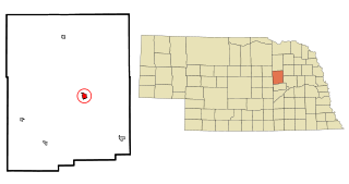
Albion is a city in and the county seat of Boone County, Nebraska, United States. The population was 1,650 at the 2010 census.

<span class="mw-page-title-main">Marthasville, Missouri</span> City in Missouri, United States

Marthasville is a city in Warren County, Missouri, United States. The population was 1,136 at the 2010 census. The Katy Trail, a 240-mile long bike path, passes through Marthasville.

<span class="mw-page-title-main">Walton, Kentucky</span> City in Kentucky, United States

Walton is a home rule-class city in Boone and Kenton counties in the U.S. state of Kentucky. The population was 5,460 at the 2020 census.

<span class="mw-page-title-main">Florence Y'all Water Tower</span> Water tower in Florence, Kentucky, United States

The Florence Y'all Water Tower is a water tower owned by the city of Florence, Kentucky, United States. It stands between the Florence Mall and Interstate 75/Interstate 71, where it is seen by millions of interstate motorists annually. The tower, built in 1974 and initially painted with the words FLORENCE MALL in giant letters, became a regional landmark after the M was changed to Y' to address legal concerns.

References

  1. "City Council Members". City of Florence, Kentucky. Archived from the original on December 19, 2019. Retrieved December 19, 2019.
  2. Tierney, Grace (December 21, 2022). "New Florence Mayor continues family legacy of public service". LINK nky. Archived from the original on January 19, 2023. Retrieved January 19, 2023.
  3. "2020 U.S. Gazetteer Files". United States Census Bureau. Archived from the original on March 19, 2022. Retrieved March 18, 2022.
  4. 1 2 U.S. Geological Survey Geographic Names Information System: Florence, Kentucky
  5. "Annual Estimates of the Resident Population for Incorporated Places in Kentucky: April 1, 2020 to July 1, 2022". United States Census Bureau. Archived from the original on May 20, 2023. Retrieved May 26, 2023.
  6. "Summary and Reference Guide to House Bill 331 City Classification Reform" (PDF). Kentucky League of Cities. Archived (PDF) from the original on March 4, 2016. Retrieved December 30, 2014.
  7. 1 2 "QuickFacts: Florence city, Kentucky". census.gov. Retrieved January 1, 2022.
  8. 1 2 Kleber, John, ed. (1992). "Florence". The Kentucky Encyclopedia. University Press of Kentucky. ISBN   9780813128832.
  9. Rennick, Robert M. (1987). Kentucky Place Names. University Press of Kentucky. p. 104. ISBN   9780813126319 . Retrieved April 28, 2013.
  10. Boone County Historical Society. "Florence, Boone County, Kentucky". B.C.H.S. (Florence), 1958.
  11. "Geographic Identifiers: 2010 Demographic Profile Data (G001): Florence city, Kentucky". U.S. Census Bureau, American Factfinder. Archived from the original on February 12, 2020. Retrieved November 20, 2013.
  12. "Annual Estimates of the Resident Population for Incorporated Places in Kentucky: April 1, 2020 to July 1, 2022". United States Census Bureau. Archived from the original on May 20, 2023. Retrieved May 26, 2023.
  13. "Census of Population and Housing". Census.gov. Archived from the original on July 1, 2021. Retrieved June 4, 2015.
  14. "U.S. Census website". United States Census Bureau. Archived from the original on December 27, 1996. Retrieved January 31, 2008.
  15. "2015 City of Florence CAFR" (PDF). Archived from the original (PDF) on April 18, 2016. Retrieved January 31, 2016.
  16. "2015 NKY 200". Archived from the original on June 23, 2015. Retrieved January 31, 2016.
  17. "TEAM HISTORY - Florence Freedom". Tim's Unofficial Frontier League History Page. Archived from the original on July 4, 2009. Retrieved January 1, 2010.
  18. "Kentucky Public Library Directory". Kentucky Department for Libraries and Archives. Archived from the original on January 11, 2019. Retrieved June 5, 2019.