Columbia, Kentucky

Last updated

Columbia, Kentucky
Columbia kentucky night 2008.jpg
Adair County Courthouse
Adair County Kentucky Incorporated and Unincorporated areas Columbia Highlighted 2116750.svg
Location of Columbia in Adair County, Kentucky.
Coordinates: 37°6′2″N85°18′22″W / 37.10056°N 85.30611°W / 37.10056; -85.30611
Country United States
State Kentucky
County Adair
Government
  Type Mayor-Council
  MayorPamela Hoots
  City AttorneyMarshall Loy
  Governing bodyColumbia Council
Area
[1]
  Total4.91 sq mi (12.72 km2)
  Land4.87 sq mi (12.62 km2)
  Water0.04 sq mi (0.10 km2)
Elevation
748 ft (228 m)
Population
 (2020)
  Total4,845
  Estimate 
(2022) [2]
4,846
  Density994.46/sq mi (383.94/km2)
Time zone UTC-6 (Central (CST))
  Summer (DST) UTC-5 (CDT)
ZIP codes
42715, 42728, 42735
Area code(s) 270 & 364
FIPS code 21-16750
GNIS feature ID0489885
Website www.cityofcolumbiaky.com

Columbia is a home rule-class city [3] just above Russell Creek in Adair County, Kentucky, United States. The population was 4,452 at the 2010 census. Columbia is the seat of its county. [4]

Contents

History

The area was settled c.1802 by Daniel Trabue. The post office was opened on April 1, 1806, by John Field, who also ran the local store.

Camp Boyle, located north of the town square, was an important camp and muster site for the Union Army during the Civil War (1861–1865). [5] [6] The 13th Kentucky Cavalry Regiment (Union) was organized in Columbia. [7]

Geography

According to the United States Census Bureau, the city has a total area of 3.4 square miles (8.9 km2), all land.

Demographics

Historical population
CensusPop.Note
1810 175
1830 423
1840 48614.9%
1860 381
1870 50632.8%
1880 5498.5%
1900 654
1910 1,02256.3%
1920 1,0765.3%
1930 1,19511.1%
1940 1,37214.8%
1950 2,16757.9%
1960 2,2554.1%
1970 3,23443.4%
1980 3,71014.7%
1990 3,8453.6%
2000 4,0144.4%
2010 4,45210.9%
2020 4,8458.8%
2022 (est.)4,846 [8] 0.0%
U.S. Decennial Census [9]

As of the census [10] of 2010, there were 4,014 people, 1,554 households, and 893 families residing in the city. The population density was 1,167.9 per square mile (450.9/km2). There were 1,789 housing units at an average density of 520.5 per square mile (201.0/km2). The racial makeup of the city was 88.77% White, 7.68% African American, 0.25% Native American, 0.52% Asian, 0.07% Pacific Islander, 0.20% from other races, and 1.64% from two or more races. Hispanic or Latino of any race were 1.93% of the population. Some other race alone 1.08%

There were 1,554 households, out of which 24.8% had children under the age of 18 living with them, 39.9% were married couples living together, 14.5% had a female householder with no husband present, and 42.5% were non-families. 40.3% of all households were made up of individuals living alone, and 22.1% had someone living alone who was 65 years of age or older. The average household size was 2.12 and the average family size was 2.84.

In the city, the population was spread out, with 18.0% under the age of 18, 19.1% from 20 to 24, 23.1% from 25 to 44, 19.1% from 45 to 64, and 20.6% who were 65 years of age or older. The median age was 36 years. For every 100 females, there were 83.8 males. For every 100 females age 18 and over, there were 78.6 males.

The median income for a household in the city was $22,861, and the median income for a family was $31,344. Males had a median income of $23,906 versus $21,000 for females. The per capita income for the city was $17,836. About 19.9% of families and 26.6% of the population were below the poverty line, including 39.4% of those under age 18 and 17.9% of those age 65 or over.

Arts and culture

Events

Events held in Columbia, Kentucky:

Education

Public schools

Columbia Public Schools are part of the Adair County Schools School District. [12] Schools in the district include:

Colleges and universities

Lindsey Wilson College, a private four-year college.

Public library

Columbia has a lending library, the Adair County Public Library. [13]

Media

Media in Columbia include:

Infrastructure

The Louie B. Nunn Cumberland Parkway runs through Columbia as it extends from Bowling Green to Somerset. This parkway is a future corridor of Interstate 66. The addition of an interchange with a 2006 reconstruction of Highway 61 South, Columbia now has two exits on the Parkway.

Exit 49, the original exit on the parkway, merges onto Highway 55 South (also known as Jamestown Street) bringing drivers through the middle of Columbia.

Exit 47, the new exit, merges onto Highway 61 South (also known as Burkesville Street/Road) and drivers can choose to go north or go to Burkesville to the south.

The Highway 55 Bypass was officially opened on October 7, 2008, for more information see below.

Columbia Bypass

After years of promises by various governors and other Kentucky officials, construction began early in May 2007, which culminated in an official ground-breaking ceremony by the former Governor himself on May 15, 2007 [14] near the front of the newly constructed Adair County Elementary School, which faces the direction of the bypass.

The Columbia Bypass was opened to the public on October 7, 2008, featuring a traffic light at the intersection of the bypass and North 55 as well as a traffic light at the intersection of South 61. The bypass has relieved a majority of the downtown traffic.

Notable people

Columbia, Kentucky was depicted in the film Resurrection Mary starring Wilford Brimley in 2002. The film was directed by another Columbia native, Matthew Arnold (director) as part of the USC School of Cinematic Arts graduate thesis program and won awards at the Big Bear Lake International Film Festival. The filming was featured on local news stations and in USA Today .

Related Research Articles

<span class="mw-page-title-main">Russell County, Kentucky</span> County in Kentucky, United States

Russell County is a county located in the U.S. Commonwealth of Kentucky. As of the 2020 census, the population was 17,991. Its county seat is Jamestown and its largest city is Russell Springs. The county was formed on December 14, 1825, from portions of Adair, Cumberland and Wayne Counties and is named for William Russell.

<span class="mw-page-title-main">Cumberland County, Kentucky</span> County in Kentucky, United States

Cumberland County is a county located in the Pennyroyal Plateau region of the U.S. state of Kentucky. As of the 2020 census, the population was 5,888. Its county seat is Burkesville. The county was formed in 1798 and named for the Cumberland River, which in turn may have been named after the Duke of Cumberland or the English county of Cumberland.

<span class="mw-page-title-main">Adair County, Kentucky</span> County in Kentucky, United States

Adair County is a county located in the U.S. state of Kentucky. As of the 2020 census, the population was 18,903. Its county seat and only municipality is Columbia. The county was founded in 1801 and named for John Adair, then Speaker of the House in Kentucky and later Governor of Kentucky. Adair County has some of the few surviving American Chestnut trees in the United States.

<span class="mw-page-title-main">Cave City, Kentucky</span> City in Kentucky, United States

Cave City is a home rule-class city in Barren County, Kentucky, in the United States. The population was 2,356 at the 2020 census. It is part of the Glasgow Micropolitan Statistical Area.

<span class="mw-page-title-main">Fox Chase, Kentucky</span> City in Kentucky, United States

Fox Chase is a home rule-class city in Bullitt County, Kentucky, in the United States. It was formally incorporated by the state assembly in 1983. The population was 436 as of the 2020 census, down from 447 in the 2010 census.

<span class="mw-page-title-main">Lebanon Junction, Kentucky</span> City in Kentucky, United States

Lebanon Junction is a home rule-class city in Bullitt County, Kentucky, in the United States. The population was 1,746 as of the 2020 census, down from 1,813 as of the 2010 census.

<span class="mw-page-title-main">Grayson, Kentucky</span> City in Kentucky, United States

Grayson is a home rule-class city in and the county seat of Carter County, Kentucky, United States, on U.S. Route 60 and Interstate 64 in the state's northeastern region. It is approximately 21 miles west of Ashland. Within the city limits, the population was 4,217 at the 2010 census. Along with Carter County, the city is closely associated with the nearby Huntington-Ashland, WV-KY-OH Metropolitan Statistical Area and is often erroneously included in the MSA being just 9 miles west of the M.S.A's western boundary.

<span class="mw-page-title-main">Burkesville, Kentucky</span> City in Kentucky, United States

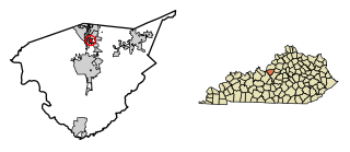
Burkesville is a home rule-class city in Cumberland County, Kentucky, in the United States. Nestled among the rolling foothills of Appalachia and bordered by the Cumberland River to the south and east, it is the seat of its county. The population was 1,521 at the 2010 census.

<span class="mw-page-title-main">Nortonville, Kentucky</span> City in Kentucky, United States

Nortonville is a home rule-class city in Hopkins County, Kentucky, in the United States. The population was 1,204 as of the 2010 census.

<span class="mw-page-title-main">Cambridge, Kentucky</span> City in Kentucky, United States

Cambridge is a home rule-class city in Jefferson County, Kentucky, United States. The population was 175 at the 2010 census.

<span class="mw-page-title-main">Douglass Hills, Kentucky</span> City in Kentucky, United States

Douglass Hills is a home rule-class city in eastern Jefferson County, Kentucky, United States. The population was 5,484 at the 2010 census, down from 5,718 at the 2000 census.

<span class="mw-page-title-main">Forest Hills, Kentucky</span> City in Kentucky, United States

Forest Hills is a home rule-class city in Jefferson County, Kentucky, United States. It was formally incorporated by the state assembly in 1959. The population was 444 at the 2010 census.

<span class="mw-page-title-main">Hurstbourne Acres, Kentucky</span> City in Kentucky, United States

Hurstbourne Acres is a home rule-class city in Jefferson County, Kentucky, United States. The population was 1,811 at the 2010 census, up from 1,504 at the 2000 census.

<span class="mw-page-title-main">Lynnview, Kentucky</span> City in Kentucky, United States

Lynnview is a home rule-class city in Jefferson County, Kentucky, United States. The population was 914 at the 2010 census.

<span class="mw-page-title-main">Parkway Village, Kentucky</span> City in Kentucky, United States

Parkway Village is a home rule-class city in Jefferson County, Kentucky, United States, and a part of the Louisville Metro government. It was developed in the 1920s and incorporated in 1941. The population was 650 at the 2010 census.

<span class="mw-page-title-main">Nicholasville, Kentucky</span> City in Kentucky, United States

Nicholasville is a home rule city in and the county seat of Jessamine County, Kentucky. The population was 31,490 during the 2020 U.S. census, making Nicholasville the 10th-largest settlement in the state.

<span class="mw-page-title-main">Edgewood, Kentucky</span> City in Kentucky, United States

Edgewood is a home rule–class city in Kenton County, Kentucky, United States. The population was 8,435 at the 2020 census. It was named for an early homestead in Walker Estates.

<span class="mw-page-title-main">Richmond, Kentucky</span> City in Kentucky, United States

Richmond is a home rule-class city in and the county seat of Madison County, Kentucky, United States. It is named after Richmond, Virginia, and is home to Eastern Kentucky University. The population was 34,585 at the 2020 census. Richmond is the fourth-largest city in the Bluegrass region and the state's seventh-largest city. It is the ninth largest population center in the state with a Micropolitan population of 106,864. The city serves as the center for work and shopping for south-central Kentucky. In addition, Richmond is the principal city of the Richmond-Berea, Kentucky Micropolitan Area, which includes all of Madison and Rockcastle counties.

<span class="mw-page-title-main">Edmonton, Kentucky</span> City in Kentucky, United States

Edmonton is a home rule-class city in and the county seat of Metcalfe County, Kentucky, United States. It is part of the Glasgow Micropolitan Statistical Area. The population was 1,671 at the 2020 census.

<span class="mw-page-title-main">Hamburg (village), New York</span> Village in New York, United States

Hamburg is a village in Erie County, New York, United States. The population was 9,696 at the 2020 census. The village is named after Hamburg, the second largest city in Germany. It is part of the Buffalo-Niagara Falls metropolitan area.

References

  1. "2020 U.S. Gazetteer Files". United States Census Bureau. Retrieved March 18, 2022.
  2. "Annual Estimates of the Resident Population for Incorporated Places in Kentucky: April 1, 2020 to July 1, 2022". United States Census Bureau. Retrieved May 26, 2023.
  3. "Summary and Reference Guide to House Bill 331 City Classification Reform" (PDF). Kentucky League of Cities. Retrieved December 30, 2014.
  4. "Find a County". National Association of Counties. Archived from the original on May 31, 2011. Retrieved June 6, 2011.
  5. Woodcock, Marcus, and Kenneth W. Noe. A Southern Boy in Blue: The Memoir of Marcus Woodcock, 9th Kentucky Infantry (U.S.A.). Knoxville: University of Tennessee Press, 1996.
  6. Kentucky, and Michael L. Cook. Report of the Adjutant General of the State of Kentucky, 1861-1866. Utica, Kentucky: McDowell Publications, 1984.
  7. Dyer, Frederick H. A Compendium of the War of the Rebellion (Des Moines, IA: Dyer Pub. Co.), 1908.
  8. "Annual Estimates of the Resident Population for Incorporated Places in Kentucky: April 1, 2020 to July 1, 2022". United States Census Bureau. Retrieved May 26, 2023.
  9. "Census of Population and Housing". Census.gov. Retrieved June 4, 2015.
  10. "U.S. Census website". United States Census Bureau . Retrieved January 31, 2008.
  11. "Columbia Downtown Days". Kentucky Department of Travel. October 13, 2017. Retrieved October 18, 2017.
  12. "Adair County Schools". Adair County Schools. Retrieved August 18, 2012.
  13. "Kentucky Public Library Directory". Kentucky Department for Libraries and Archives. Archived from the original on January 11, 2019. Retrieved June 5, 2019.
  14. "That Perfect Day: Gov. Fletcher at Bypass groundbreaking". ColumbiaMagazine.com.