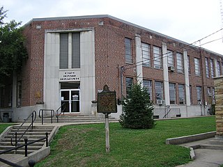
Wayne County is a county in the U.S. state of Kentucky along the southern border with Tennessee. As of the 2020 census, the population was 19,555. Its county seat is Monticello. The county, on the south-central border with Tennessee, was named for Gen. Anthony Wayne, a Revolutionary War hero. As of November 3, 2020, Wayne County is a wet county—a measure allowing the sales and consumption of alcoholic drinks passed by a margin of 4,901 for and 3,966 against.

Hopkins County is a county located in the western part of the U.S. state of Kentucky. As of the 2020 census, the population was 45,423. Its county seat is Madisonville. Hopkins County was created December 9, 1806 from Henderson County. It was named for General Samuel Hopkins, an officer in both the American Revolutionary War and War of 1812, and later a Kentucky legislator and U.S. Congressman.

Hardin County is a county located in the central part of the U.S. state of Kentucky. Its county seat is Elizabethtown. The county was formed in 1792. Hardin County is part of the Elizabethtown-Fort Knox, KY Metropolitan Statistical Area, as well as the Louisville/Jefferson County—Elizabethtown-Bardstown, KY-IN Combined Statistical Area. As of the 2020 census, the population was 110,702.

Shepherdsville is a home rule-class city on the Salt River in Bullitt County, Kentucky, in the United States. It is the second largest city and seat of its county, located just south of Louisville. The population was 14,201 during the 2020 U.S. Census.

Cold Spring is a home rule-class city in Campbell County, Kentucky, in the United States. The population was 6,216 at the 2020 census. It is part of the Cincinnati-Northern Kentucky metropolitan area.

Spring Mill is a home rule-class city in Jefferson County, Kentucky, United States. The population was 287 at the 2010 census, down from 380 at the 2000 census.

Taylor Mill is a home rule-class city in Kenton County, Kentucky, in the United States. The population was 6,873 at the 2020 census.

Somerset is a home rule-class city in Pulaski County, Kentucky, United States. The city population was 11,924 according to the 2020 census. It is the seat of Pulaski County.

Georgetown is a home rule-class city in Scott County, Kentucky, United States. The population was 37,086 at the 2020 census. It is the 6th-largest city by population in the U.S. state of Kentucky. It is the seat of its county. It was originally called Lebanon when founded by Rev. Elijah Craig and was renamed in 1790 in honor of President George Washington. Historically, settlers were drawn to Georgetown for its Royal Spring.

Harold Dallas Rogers is an American lawyer and politician serving his 22nd term as the U.S. representative for Kentucky's 5th congressional district, having served since 1981. He is a member of the Republican Party. Upon Don Young's death in 2022, Rogers became the dean of the House of Representatives.

The Louisville metropolitan area is the 43rd largest metropolitan statistical area (MSA) in the United States. It had a population of 1,395,855 in 2020 according to the latest official census, and its principal city is Louisville, Kentucky.
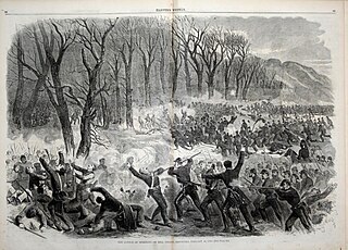
The Battle of Mill Springs, also known as the Battle of Fishing Creek in the Confederacy, and the Battle of Logan's Cross Roads or Battle of Somerset in the Union, was fought in Wayne and Pulaski counties, near current Nancy, Kentucky, on January 19, 1862, as part of the American Civil War. The Union victory concluded an early Confederate offensive campaign in south central Kentucky.

Brent Woods was an African American Buffalo Soldier in the United States Army and a recipient of America's highest military decoration—the Medal of Honor—for his actions in the Indian Wars of the western United States.

Kentucky Route 90 is a major east–west state highway in southern Kentucky. The route is 134.734 miles (216.833 km) long, and it traverses Barren, Metcalfe, Cumberland, Clinton, Wayne, Pulaski, McCreary and Whitley Counties in southern Kentucky. It runs from the KY 70 junction near Interstate 65 in Cave City to US 25W about 8 miles (13 km) from Interstate 75.
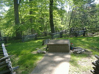
The Confederate Mass Grave Monument in Somerset in Pulaski County, Kentucky, near Nancy, Kentucky, honors the Confederate soldiers who are buried here who died at the Battle of Mill Springs. These soldiers were from Alabama, Mississippi, and Tennessee, and number over one hundred in total.
Keene is a home rule-class city located in Jessamine County, Kentucky, in the United States. It is home to the Keene Springs Hotel. The U.S. Census Bureau does not record Keene as a city and does not publish a population figure for the community.

The Mill Springs Mill, located off Kentucky Route 90 at Mill Springs in Wayne County, Kentucky, is a historic watermill built in 1877. It was listed on the National Register of Historic Places in 1973. It is the centerpiece of Mill Springs Park.

The Mill Springs Battlefield National Monument was the location of the Battle of Mill Springs in January 1862. It was declared to be a U.S. National Historic Landmark in 1993 and authorized as a national monument in 2019. After acquisition of property by the National Park Service it was established as a unit on September 22, 2020.