
Map of ward boundary

The 6th Ward or Sixth Ward is one of the seventeen Wards of New Orleans, located in the Downtown section of the city of New Orleans, Louisiana.
The 6th Ward or Sixth Ward is one of the seventeen Wards of New Orleans, located in the Downtown section of the city of New Orleans, Louisiana.
The 6th Ward is a long narrow ward stretching back from the Mississippi River. The boundary to down-river or "lower" side (to the north east in this case) is Esplanade Avenue, across which is the 7th Ward. The upper limit is Saint Philip Street, across which is the 5th Ward. The back boundary is Bayou St. John, the land across which is also part of the 5th Ward. This geographically small ward is just under 40 blocks from front to back, but only 4 blocks wide.
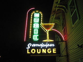
At the Riverfront is the Governor Nicholls Street Wharf. Just back from the wharf is the lower terminus of the Riverfront Streetcar line. Continuing inland, beyond a flood wall is the French Market and the old New Orleans Mint building, now a museum. Beyond a largely commercial section of Decatur Street which includes some of the city's better known music clubs and bars is the still largely residential section of the lower French Quarter. Cabrini Park is a piece of public green space here in the city's oldest urban neighborhood. On the other side of Rampart Street, the 6th Ward includes the heart of the Tremé neighborhood, including Saint Augustine Church and the Backstreet Cultural Museum. The Ward continues back along Esplanade Ridge, developed by the city's Creole communities in the 19th century, including elegant old mansions along Esplanade, one of which was the residence of Edgar Degas during the time he stayed with his relatives in the city. Just back from Broad St. is the former home of jazz musician Paul Mares, where the New Orleans Rhythm Kings rehearsed while they were in town. At the back of the Ward along the Bayou is the historic home of James Pitot, second Mayor of New Orleans, now the Pitot House museum.

The French Quarter, also known as the Vieux Carré, is the oldest neighborhood in the city of New Orleans. After New Orleans was founded in 1718 by Jean-Baptiste Le Moyne de Bienville, the city developed around the Vieux Carré, a central square. The district is more commonly called the French Quarter today, or simply "The Quarter", related to changes in the city with American immigration after the 1803 Louisiana Purchase. Most of the extant historic buildings were constructed either in the late 18th century, during the city's period of Spanish rule, or were built during the first half of the 19th century, after U.S. purchase and statehood.

Streetcars in New Orleans have been an integral part of the city's public transportation network since the first half of the 19th century. The longest of New Orleans' streetcar lines, the St. Charles Avenue line, is the oldest continuously operating street railway system in the world. Today, the streetcars are operated by the New Orleans Regional Transit Authority (RTA).

Tremé is a neighborhood in New Orleans, Louisiana. "Tremé" is often rendered as Treme, and the neighborhood is sometimes called by its more formal French name, Faubourg Tremé; it is listed in the New Orleans City Planning Districts as Tremé / Lafitte when including the Lafitte Projects.

The Faubourg Marigny is a neighborhood of the city of New Orleans, Louisiana, United States.

The Ninth Ward or 9th Ward is a distinctive region of New Orleans, Louisiana, which is located in the easternmost downriver portion of the city. It is geographically the largest of the 17 Wards of New Orleans. On the south, the Ninth Ward is bounded by the Mississippi River. On the western or "upriver" side, the Ninth Ward is bounded by Franklin Avenue, then Almonaster Avenue, then People's Avenue. From the north end of People's Avenue the boundary continues on a straight line north to Lake Pontchartrain; this line is the boundary between the Ninth and the city's Eighth Ward. The Lake forms the north and northeastern end of the ward. St. Bernard Parish is the boundary to the southeast, Lake Borgne farther southeast and east, and the end of Orleans Parish to the east at the Rigolets.

The Industrial Canal is a 5.5 mile (9 km) waterway in New Orleans, Louisiana, United States. The waterway's proper name, as used by the U.S. Army Corps of Engineers and on NOAA nautical charts, is Inner Harbor Navigation Canal (IHNC). The more common "Industrial Canal" name is used locally, both by commercial mariners and by landside residents.

The 8th Ward is a section of New Orleans, Louisiana. It is one of the Downtown Wards of New Orleans, with a Creole history.

The 7th Ward is a section of New Orleans, Louisiana. It is geographically the third largest of the 17 Wards of New Orleans, after the 9th Ward and 15th Ward.

The 17th Ward is one of the 17 Wards of New Orleans, a section of the city of New Orleans, Louisiana. New Orleans Districts and Wards. The 17th Ward, along with the 16th, was formed when the City of New Orleans annexed City of Carrollton in 1870.
The 4th Ward or Fourth Ward is a division of the city of New Orleans, Louisiana, United States, one of the 17 Wards of New Orleans.


The 14th Ward or Fourteenth Ward is a section of the city of New Orleans, Louisiana, one of the 17 Wards of New Orleans. The Ward was formed in 1870 from part of Jefferson City and the town of Greenville, which were annexed by New Orleans.


The 10th Ward is a division of the city of New Orleans, Louisiana. The 10th Ward is one of the 17 wards of New Orleans. The ward is one of the city's Uptown wards, formerly the old Faubourg Lafayette annexed by New Orleans in the 1850s.

Esplanade Avenue is a historic street in New Orleans, Louisiana. It runs northwest from the Mississippi River to Beauregard Circle at the entrance to City Park.

The Canal Streetcar Line is a historic streetcar line in New Orleans, Louisiana. It is operated by the New Orleans Regional Transit Authority (RTA). It originally operated from 1861 to 1964. It was redesigned and rebuilt between 2000 and 2004, and operation was reinstated in 2004 after a 40-year hiatus. Primarily running along its namesake street, Canal Street, it consists of two branches named for their outer terminals, totaling about 5+1⁄2 miles (8.9 km) in length: "Canal–Cemeteries" and "Canal–City Park/Museum". Each branch is denoted with the red and light green colors respectively on most RTA publications.

Mid-City is a neighborhood of the city of New Orleans. A sub-district of the Mid-City District Area, its boundaries as defined by the New Orleans City Planning Commission are: City Park Avenue, Toulouse Street, North Carrollton, Orleans Avenue, Bayou St. John and St. Louis Street to the north, North Broad Street to the east, and the Pontchartrain Expressway to the west. It is a historic district on the National Register of Historic Places. In common usage, a somewhat larger area surrounding these borders is often also referred to as part of Mid-City.
Fairgrounds is a neighborhood of the city of New Orleans. A subdistrict of the Mid-City District Area, its boundaries as defined by the New Orleans City Planning Commission are: Florida Avenue, Dugue, Treasure, Republic and Abundance Streets to the north, North Broad Street to the east, Esplanade Avenue to the south and Bayou St. John to the west.

Faubourg St. John, is a neighborhood in New Orleans, Louisiana, located just north of Broad Street at the intersection of Orleans Avenue. Faubourg St. John is approximately 75 city blocks in area and has an average elevation of about one foot above sea level. It was built along what is known as the Esplanade Ridge. The Esplanade Ridge Historic District was added to the National Register of Historic Places in 1980.
| Topics | |
|---|---|
| Government | |
| Colleges and Universities | |
| Sports |
|
| Festivals | |