Related Research Articles
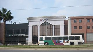
The New Orleans Regional Transit Authority is a public transportation agency based in New Orleans. The agency was established by the Louisiana State Legislature in 1979, and has operated bus and historic streetcar service throughout the city since 1983. In 2022, the system had a ridership of 7,244,700, or about 31,600 per weekday as of the second quarter of 2023, making the Regional Transit Authority the largest public transit agency in the state of Louisiana.

Algiers is a historic neighborhood of New Orleans and is the only Orleans Parish community located on the West Bank of the Mississippi River. Algiers is known as the 15th Ward, one of the 17 Wards of New Orleans. It was once home to many jazz musicians and is also the second oldest neighborhood in the city.

Carrollton is a historic neighborhood of Uptown New Orleans, Louisiana, USA, which includes the Carrollton Historic District, recognized by the Historic District Landmark Commission. It is the part of Uptown New Orleans farthest upriver while still being easily accessible to the French Quarter. It was historically a separate town, laid out in 1833 and incorporated on March 10, 1845. Carrollton was annexed by New Orleans in 1874, but it has long retained some elements of distinct identity.

Tremé is a neighborhood in New Orleans, Louisiana. "Tremé" is often rendered as Treme, and the neighborhood is sometimes called by its more formal French name, Faubourg Tremé; it is listed in the New Orleans City Planning Districts as Tremé / Lafitte when including the Lafitte Projects.

The Faubourg Marigny is a neighborhood of the city of New Orleans, Louisiana, United States.

The New Orleans Public Library (NOPL) is the public library service of the city of New Orleans, Louisiana, United States.

Uptown is a section of New Orleans, Louisiana, United States, on the east bank of the Mississippi River, encompassing a number of neighborhoods between the French Quarter and the Jefferson Parish line. It remains an area of mixed residential and small commercial properties, with a wealth of 19th-century architecture. It includes part or all of Uptown New Orleans Historic District, which is listed on the National Register of Historic Places.

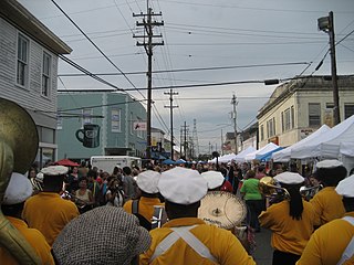
Central City is a neighborhood of the city of New Orleans. It is located in the 11th Ward of New Orleans in Uptown, just above the Garden District, on the "lakeside" of St. Charles Avenue. A subdistrict of the Central City/Garden District Area, its boundaries as defined by the City Planning Commission are: MLK Boulevard, South Claiborne Avenue and the Pontchartrain Expressway to the north, Magazine, Thalia, Prytania and Felicity Streets and St. Charles Avenue to the south and Toledano Street, Louisiana Avenue and Washington Avenue to the west. This old predominantly African-American neighborhood has been important in the city's brass band and Mardi Gras Indian traditions.

The 8th Ward is a section of New Orleans, Louisiana. It is one of the Downtown Wards of New Orleans, with a Creole history.


The 10th Ward is a division of the city of New Orleans, Louisiana. The 10th Ward is one of the 17 wards of New Orleans. The ward is one of the city's Uptown wards, formerly the old Faubourg Lafayette annexed by New Orleans in the 1850s.
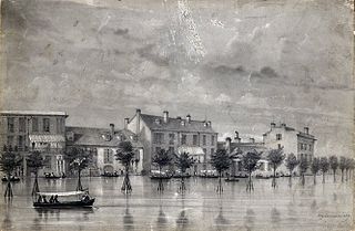
Sauvé's Crevasse was a Mississippi River levee failure in May 1849 that resulted in flooding much of New Orleans, Louisiana.
East Carrollton is a neighborhood of the city of New Orleans. A subdistrict of the Uptown/Carrollton Area, its boundaries as defined by the New Orleans City Planning Commission are: Spruce Street to the northeast, Lowerline Street to the southeast, St. Charles Avenue to the southwest and South Carrollton Avenue to the northwest.

Audubon is a neighborhood of the city of New Orleans. A subdistrict of the Uptown/Carrollton Area, its boundaries as defined by the New Orleans City Planning Commission are: South Claiborne Avenue to the north, Jefferson Avenue to the east, the Mississippi River and Magazine Street to the south, and Lowerline Street to the west. The name Audubon comes from Audubon Park, one of the largest parks in the city, which is located in the southern portion of the district. The area is also known as the "University District," as it is also home of Tulane and Loyola Universities, as well as the former St. Mary’s Dominican College, and Newcomb College. The Audubon neighborhood was also the home of the original campus of Leland University. The section of the neighborhood upriver from Audubon Park incorporates what was the town of Greenville, Louisiana until it was annexed to New Orleans in the 19th century; locals still sometimes call that area "Greenville".

Carrollton Avenue is a major thoroughfare stretching 3.9 miles (6.3 km) across the Uptown/Carrollton and Mid-City districts of New Orleans. South Carrollton Avenue runs from St. Charles Avenue in the Riverbend in a northeast lake-bound direction through Carrollton and into Mid-City. After crossing Canal Street it continues as North Carrollton Avenue until intersecting with Esplanade Avenue and Wisner Boulevard at the entrance to City Park.

Esplanade Avenue is a historic street in New Orleans, Louisiana. It runs northwest from the Mississippi River to Beauregard Circle at the entrance to City Park.

Hollygrove is a neighborhood of the city of New Orleans, Louisiana, located in the city's 17th Ward. A subdistrict of the Uptown/Carrollton area, the boundaries as defined by the New Orleans City Planning Commission are the following: Palmetto Street to the north, Cambronne, Edinburgh, Forshey, Fig and Leonidas Streets to the east, Earhart Boulevard to the south and the Jefferson Parish boundary to the west. Conrad playground, the Cuccia-Byrnes playground and Larry Gilbert baseball stadium are located in Hollygrove. The Hollygrove Market and Farm is also located in Hollygrove. Particularly notable people, including rapper Lil Wayne, have grown up in the neighborhood.

Mid-City is a neighborhood of the city of New Orleans. A sub-district of the Mid-City District Area, its boundaries as defined by the New Orleans City Planning Commission are: City Park Avenue, Toulouse Street, North Carrollton, Orleans Avenue, Bayou St. John and St. Louis Street to the north, North Broad Street to the east, and the Pontchartrain Expressway to the west. It is a historic district on the National Register of Historic Places. In common usage, a somewhat larger area surrounding these borders is often also referred to as part of Mid-City.
Leonidas is a neighborhood designation in the city of New Orleans. A subdistrict of the Uptown/Carrollton Area, its boundaries as defined by the New Orleans City Planning Commission are: South Claiborne Avenue, Leonidas and Fig Streets to the north, South Carrollton Avenue to the east, the Mississippi River and Jefferson Parish to the west. Although an official city planning district name, the name "Leonidas" is not widely used nor has it any historical usage and the area is usually referred to by the larger neighborhood "Uptown, or "Carrollton".
The neighborhood of Faubourg Lafayette is a division in the city of New Orleans, Louisiana. It is a portion of the 10th Ward of New Orleans, and part of Central City, New Orleans. The boundaries are the lake side of St. Charles Avenue from Jackson Avenue to the Pontchartrain Expressway, back to Simon Bolivar Avenue.
References
- 1 2 Campanella, Richard (June 1, 2011). "City neighborhoods: a matter of evolving perception". The Lens. Retrieved July 20, 2022.
- ↑ "Neighborhood Definition". www.datacenterresearch.org. 2013. Retrieved July 20, 2022.
- ↑ Planning District 1a (Map). March 6, 2015. Archived from the original on March 6, 2015. Retrieved October 22, 2021.
- ↑ Planning District 1b (Map). March 6, 2015. Archived from the original on March 6, 2015. Retrieved October 22, 2021.
- 1 2 3 4 "Planning districts and neighborhoods" (PDF).
- ↑ Planning District 2 (Map). March 6, 2015. Archived from the original on March 6, 2015. Retrieved October 22, 2021.
- ↑ Planning District 3 (Map). October 16, 2014. Archived from the original on October 16, 2014. Retrieved October 22, 2021.
- ↑ Planning District 5 (Map). February 22, 2015. Archived from the original on February 22, 2015. Retrieved October 22, 2021.
- ↑ Planning District 6 (Map). July 27, 2015. Archived from the original on July 27, 2015. Retrieved October 22, 2021.
- ↑ Planning District 7 (Map). March 22, 2015. Archived from the original on March 22, 2015. Retrieved October 22, 2021.
- ↑ Planning District 8 (Map). September 14, 2014. Archived from the original on September 14, 2014. Retrieved October 22, 2021.
- ↑ Planning District 9 (Map). December 28, 2014. Archived from the original on December 28, 2014. Retrieved October 22, 2021.
- ↑ Planning District 12 (Map). March 6, 2015. Archived from the original on March 6, 2015. Retrieved October 22, 2021.
- ↑ "old aurora latitude longitude - Google Search". www.google.com. Retrieved July 24, 2022.
- ↑ "New Orleans Ward Boundaries". nutrias.org. Retrieved July 24, 2022.
- ↑ "The Wards of New Orleans |" . Retrieved July 24, 2022.