The Faubourg Marigny is a neighborhood of the city of New Orleans, Louisiana, United States.

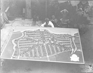
Pontchartrain Park is a historically registered neighborhood of the city of New Orleans. A subdistrict of the Gentilly District Area, its boundaries as defined by the City Planning Commission are: Leon C. Simon Drive to the north, the Industrial Canal to the east, Dreux Avenue to the south and Peoples Avenue to the west.

The 8th Ward is a section of New Orleans, Louisiana. It is one of the Downtown Wards of New Orleans, with a Creole history.

The 7th Ward is a section of New Orleans, Louisiana. It is geographically the third largest of the 17 Wards of New Orleans, after the 9th Ward and 15th Ward.

Navarre is a neighborhood of the city of New Orleans. A subdistrict of the Lakeview District Area, its boundaries as defined by the City Planning Commission are: I-610, Canal Boulevard and Florida Boulevard to the north, Orleans Avenue to the east, City Park Avenue to the south and the Pontchartrain Expressway and Pontchartrain Boulevard to the west.
The city planning commission for New Orleans divided the city into 13 planning districts and 73 distinct neighborhoods in 1980. Although initially in the study 68 neighborhoods were designated, and later increased by the City Planning Commission to 76 in October 2001 based in census data, most planners, neighborhood associations, researchers, and journalists have since widely adopted the 73 as the number and can even trace the number back to the early 1900s. While most of these assigned boundaries match with traditional local designations, some others differ from common traditional use. This is a result of the city planning commission's wish to divide the city into sections for governmental planning and zoning purposes without crossing United States census tract boundaries. While most of the listed names have been in common use by New Orleanians for generations, some designated names are rarely heard outside the planning commission's usage.

Gentilly is a broad, predominantly middle-class and racially diverse section of New Orleans, Louisiana. The Gentilly neighborhood is bounded by Lake Pontchartrain to the north, France Road to the east, Bayou St. John to the west, and CSX Transportation railroad tracks to the south.

Elysian Fields Avenue is a broad, straight avenue in New Orleans named after the Avenue des Champs-Élysées in Paris. It courses south to north from the Lower Mississippi River to Lake Pontchartrain, a distance of approximately 5 miles (8.0 km). The avenue intersects with Interstate 610, Interstate 10, and U.S. Highway 90, Gentilly Boulevard passing by Brother Martin High School. The part between North Claiborne Avenue and Gentilly Boulevard is Louisiana Highway 3021 ; the piece from N. Claiborne Avenue south to St. Claude Avenue carries Louisiana Highway 46.

Pontchartrain Rail-Road was the first railway in New Orleans, Louisiana. Chartered in 1830, the railroad began carrying people and goods between the Mississippi River front and Lake Pontchartrain on 23 April 1831. It closed more than 100 years later.

Gentilly Woods is a neighborhood of the city of New Orleans. A subdistrict of the Gentilly District Area, its boundaries as defined by the City Planning Commission are: Dreux Avenue to the north, Industrial Canal to the east, Gentilly Boulevard to the south and People's Avenue to the west.
City Park is a neighborhood of the city of New Orleans, USA. A subdistrict of the Lakeview District Area, its boundaries as defined by the City Planning Commission are: Allen Toussaint Boulevard to the north, Bayou St. John to the east, Orleans Avenue, North Carrollton Avenue and Toulouse Street to the south and City Park and Orleans Avenues to the west. The neighborhood is named after and dominated by City Park.
Lakeshore/Lake Vista is a neighborhood of the city of New Orleans, Louisiana. A subdistrict of the Lakeview District Area, its boundaries as defined by the City Planning Commission are: Lake Pontchartrain to the north, Bayou St. John to the east, Allen Toussaint Boulevard to the south and Pontchartrain Boulevard and the New Basin Canal to the west. The neighborhood is composed of the Lakeshore and Lake Vista subdivisions, built on land reclaimed from Lake Pontchartrain. The Lakefront is a term sometimes used to name the larger neighborhood created by the Orleans Levee Board's land reclamation initiative in early 20th century New Orleans; it includes Lakeshore and Lake Vista, as well as Lakeshore Drive, the lakefront park system, the University of New Orleans, Lake Terrace, and Lake Oaks.
Dillard is a neighborhood of the city of New Orleans. A subdistrict of the Gentilly District Area, its boundaries as defined by the City Planning Commission are: Mirabeau Avenue to the north, Elysian Fields Avenue to the east, Benefit Street and I-610 to the south and Paris Avenue, Pratt Drive and the London Avenue Canal to the west.

Filmore is a neighborhood of the city of New Orleans. A subdistrict of the Gentilly District Area, its boundaries as defined by the City Planning Commission are: * Allen Toussaint Boulevard to the north, London Avenue Canal to the east, Press Drive, Paris Avenue and Harrison Avenue to the south and Bayou St. John to the west.

Gentilly Terrace is a neighborhood of the city of New Orleans. A subdistrict of the Gentilly District Area, its boundaries as defined by the City Planning Commission are: Filmore Avenue to the north, People's Avenue to the east, Dahlia Walk and Benefit Street to the south and Elysian Fields Avenue to the west. Gentilly Terrace may be further divided into Gentilly Terrace & Gardens, Edgewood Park and Fairmont Park, all three of which possess organized, distinct, and active neighborhood associations.
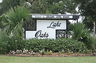
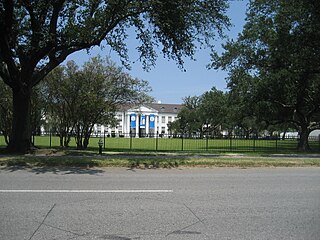
Lake Terrace/Lake Oaks is a neighborhood of the city of New Orleans, Louisiana. A sub-district of the city's Gentilly District, its boundaries as defined by the City Planning Commission are: Lake Pontchartrain to the north; the Industrial Canal to the east; Leon C. Simon Drive, Elysian Fields Avenue, New York Street, the London Avenue Canal, and Allen Toussaint Boulevard to the south; and Bayou St. John to the west. The neighborhood comprises the Lake Terrace and Lake Oaks subdivisions, the principal campus of the University of New Orleans, and the University of New Orleans Research & Technology Park — all built on land reclaimed from Lake Pontchartrain.
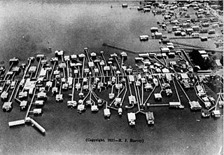
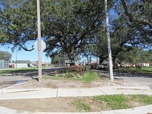
Milneburg was a town on the southern shore of Lake Pontchartrain in Louisiana that was absorbed into the city of New Orleans. A neighborhood to the south of this area is still sometimes known by this name; the former location of Milneburg is now in the Lake Terrace/Lake Oaks, New Orleans section, mostly under the current campus of the University of New Orleans.
St. Anthony is a neighborhood of the city of New Orleans. A subdistrict of the Gentilly District Area, its boundaries as defined by the City Planning Commission are: New York Street to the north, Elysian Fields Avenue to the east, Mirabeau Avenue to the south and the London Avenue Canal to the west.

St. Roch is a neighborhood of the U.S. city of New Orleans. A subdistrict of the Bywater District Area, its boundaries as defined by the City Planning Commission are: Lafreniere Street, Paris Avenue, I-610, Benefit Street, and Dahlia Walk to the north; People's and Almonaster Avenues to the east; St. Claude Avenue to the south; Elysian Fields Avenue, Hope, Frenchmen, Duels, St. Anthony, Industry, Allen, & Agriculture Streets, A.P. Tureaud Avenue, Abundance, Republic, Treasure, & Dugue Streets, and Florida & St. Bernard Avenues to the west.
Pines Village is a neighborhood in the city of New Orleans, Louisiana, United States. A subdistrict of the New Orleans East area, its boundaries as defined by the City Planning Commission are: Downman Road and Interstate 10 to the east, Chef Menteur Highway to the south, Lake Pontchartrain and Morrison Road to the north, and the Industrial Canal to the west.