Gentilly, New Orleans

Last updated

Gentilly
Gentilly Chillin On Sugar Hill.JPG
Gentilly "Sugar Hill" section, New Orleans
Map New Orleans.jpg
Red pog.svg
Gentilly
Location of Gentilly in the New Orleans metro area in New Orleans
Coordinates: 30°00′45″N90°03′37″W / 30.0125°N 90.0603°W / 30.0125; -90.0603
CountryUnited States
StateLouisiana
City New Orleans
Government
  Mayor LaToya Cantrell
Time zone UTC-6 (CST)
  Summer (DST) UTC-5 (CDT)
Area code 504

Gentilly is a broad, predominantly middle-class and racially diverse section of New Orleans, Louisiana. The Gentilly neighborhood is bounded by Lake Pontchartrain to the north, France Road to the east, Bayou St. John to the west, and CSX Transportation railroad tracks to the south.

Contents

The major north-south streets are Franklin Avenue, Elysian Fields Avenue, St. Anthony, St. Bernard, St. Roch, Paris, Wisner, A.P. Tureaud (formerly London) Avenue and Press. The east-west streets are Lakeshore Drive, Leon C. Simon, Allen Toussaint Blvd (a section of which was formerly called Hibernia), Prentiss, Harrison, Filmore, Mirabeau, Hayne, Chef Menteur, and Gentilly.

History

The first part of Gentilly to be developed was along the Gentilly Ridge, a long stretch of high ground along the former banks of Bayou Gentilly. A road, originally "Gentilly Road", was built on the ridge, and formed the eastern path into the oldest part of the city, today's French Quarter to Chef Menteur Pass. The high ground became Gentilly Boulevard and U.S. Highway 90, part of the Old Spanish Trail from St. Augustine, Florida to Los Angeles, California.

Settlement was originally mostly confined to along the long narrow ridge, plus Milneburg, built on elevated piers on the shore of Lake Pontchartrain. Most of the ground between the ridge and the lake was swampy. The first residential section adjacent to the ridge, Gentilly Terrace, dating to the early 20th century, was built by excavating and piling up the earth in the shallow swamp to create blocks of terraced land where houses could be built. With the development of improved drainage pumps (see drainage in New Orleans), land reclamation and higher lakefront levees, the land extending from the ridge to the lake was developed by the mid-20th century, and the entire area popularly came to be known as Gentilly.

Gentilly has traditionally been defined variously. Some definitions include a somewhat wider area, extending the neighborhood into the Upper 9th Ward. Some older New Orleanians extend the definition even further, to include the section of old Gentilly on the east side of the Industrial Canal, now part of Eastern New Orleans. Other definitions diminish the area occupied by Gentilly by placing the western boundary of Gentilly along the London Avenue Canal, not Bayou St. John, and the northern boundary along Leon C. Simon Drive, not the shore of Lake Pontchartrain. By this reckoning, Mirabeau Gardens, [1] Vista Park and Oak Park, lying between the London Avenue Canal and Bayou St. John, fall outside of Gentilly, as do the Lakefront subdivisions of Lake Terrace and Lake Oaks, and the Lakefront campus of the University of New Orleans which doesn’t necessarily imply that these areas are disregarded as a “part” of Gentilly.

Hurricane Katrina

Apart from the natural high ground along the Gentilly Ridge and the Lakefront section, itself raised above sea level on man-made land created by a project of the Orleans Levee Board in the early 20th century, Gentilly was badly damaged following Hurricane Katrina. The London Avenue Canal floodwalls were breached in two places by Katrina's storm surge, flooding most of the area. Gentilly's population has slowly returned, with most homes requiring major gutting and repair work before they could be reoccupied. As of the start of 2007, the area is moderately populated with something less than half of its pre-Katrina residents and businesses having returned.

Archdiocese of New Orleans decided to close Redeemer-Seton High School while building a new campus for Holy Cross High School on Paris Avenue, on the former sites of St. Francis Cabrini Church and School and Redeemer-Seton. Marian Central Catholic Middle School, formerly St. Raphael School, has been demolished, and the parishes of St. Raphael and St. Frances Cabrini have been merged to form Transfiguration parish, currently (as of February 2010) holding services on the campus of the University of New Orleans as well as in the former St. Raphael's church building which has since been restored.

2007 tornado

On February 13, 2007, an EF2 tornado struck the Pontchartrain Park neighborhood in the town, many FEMA trailer created after the storm were heavily damaged or destroyed, including one where an elderly woman was killed. Other structures, homes, trees, and power poles and lines were damaged and 10 other people were injured. [2]

Bus service

Bus service from the New Orleans Regional Transit Authority (NORTA):

Cityscape

Gentilly is bounded by Lake Pontchartrain to the north, Interstate 610 to the south, City Park to the west, and the Industrial Canal to the east. [4]

Neighborhoods

Neighborhoods in the area include:

Government and infrastructure

The Federal Bureau of Investigation operates its New Orleans Field Office in Gentilly. [5]

Education

Primary and secondary schools

Benjamin Franklin High School BenFranklinSchoolNOLA28May07B.jpg
Benjamin Franklin High School

Three universities, the University of New Orleans, Southern University at New Orleans, and Dillard University are located in Gentilly. New Orleans Baptist Theological Seminary's main campus is also located in Gentilly. [4] New Orleans Public Schools operates district schools, while Recovery School District oversees charter schools. Public district and charter schools in Gentilly:

Private schools in Gentilly:

Public libraries

Norman Mayer Branch New Gentilly Library 2012.jpg
Norman Mayer Branch

The Norman Mayer Branch of the New Orleans Public Library is in Gentilly. It was damaged in Hurricane Katrina. The library, in a new $5.7 million facility, [9] reopened on March 20, 2012. The 18,000-square-foot (1,700 m2), two-story facility had 26 computers and about 40,000 volumes of books as of 2012. It had a price tag of $5.7 million. The post-Katrina temporary library, located in a strip center, had 19 computers. [10]

The Federal Emergency Management Agency (FEMA) was to pay for the costs of demolition of the previous library and construction of the new library since the previous facility had been, according to FEMA's estimation, over 50% damaged by Katrina. The features and amenities present in the new facility that were not in the previous facility were financed by other sources, including New Orleans municipal bond sales and funds from the Louisiana Recovery Authority. The "design-build" process, one specially allowed only in parishes affected by Hurricane Katrina under Louisiana law, was used to rebuild this library and four others. [11] Lee Ledbetter & Associates of New Orleans served as the architectural firm, and Gibbs Construction served as the construction company. [12] Lee Ledbetter & Associates worked with Kansas City, Missouri firm Gould Evans & Associates to design this library and four others. [13] Lee Ledbetter of Lee Ledbetter & Associates stated that the libraries his company designed were made to have better access to public transportation and have reduced utility usage, including having electricity and water-saving features, in order to be more cost effective. [11]

Binx Bolling, the protagonist of Walker Percy's National Book Award–winning 1961 novel The Moviegoer , lives in Gentilly. [14]

Related Research Articles

<span class="mw-page-title-main">New Orleans Regional Transit Authority</span> Public transit operator in New Orleans, Louisiana

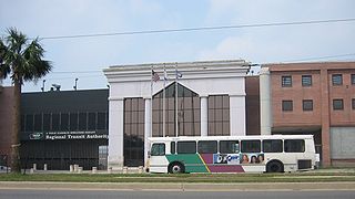
The New Orleans Regional Transit Authority is a public transportation agency based in New Orleans. The agency was established by the Louisiana State Legislature in 1979, and has operated bus and historic streetcar service throughout the city since 1983. In 2023, the system had a ridership of 9,707,300, or about 29,700 per weekday as of the fourth quarter of 2023, making the Regional Transit Authority the largest public transit agency in the state of Louisiana.

<span class="mw-page-title-main">9th Ward of New Orleans</span>

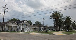
The Ninth Ward or 9th Ward is a distinctive region of New Orleans, Louisiana, which is located in the easternmost downriver portion of the city. It is geographically the largest of the 17 Wards of New Orleans. On the south, the Ninth Ward is bounded by the Mississippi River. On the western or "upriver" side, the Ninth Ward is bounded by Franklin Avenue, then Almonaster Avenue, then People's Avenue. From the north end of People's Avenue the boundary continues on a straight line north to Lake Pontchartrain; this line is the boundary between the Ninth and the city's Eighth Ward. The Lake forms the north and northeastern end of the ward. St. Bernard Parish is the boundary to the southeast, Lake Borgne farther southeast and east, and the end of Orleans Parish to the east at the Rigolets.

<span class="mw-page-title-main">Interstate 610 (Louisiana)</span> Highway in Louisiana

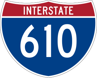
Interstate 610 (I-610) is a 4.52-mile-long (7.27 km) auxiliary route of I-10 that lies almost entirely within the city limits of New Orleans, Louisiana, bypassing its Central Business District.

<span class="mw-page-title-main">London Avenue Canal</span>

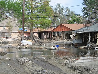
The London Avenue Canal is a drainage canal in New Orleans, Louisiana, used for pumping rain water into Lake Pontchartrain. The canal runs through the 7th Ward of New Orleans from the Gentilly area to the Lakefront. It is one of the three main drainage canals responsible for draining rainwater from the main basin of New Orleans. The London Avenue Canal's flood walls built atop earthen levees breached on both sides during Hurricane Katrina in 2005.

<span class="mw-page-title-main">8th Ward of New Orleans</span>

The 8th Ward is a section of New Orleans, Louisiana. It is one of the Downtown Wards of New Orleans, with a Creole history.

<span class="mw-page-title-main">7th Ward of New Orleans</span> New Orleans neighborhood in Louisiana, United States

The 7th Ward is a legally defined voting ward and a neighborhood of the city of New Orleans. A sub-district of the Mid-City District Area, its boundaries as defined by the New Orleans City Planning Commission are: A.P. Tureaud Avenue, Agriculture, Allen, Industry, St. Anthony, Duels, Frenchmen and Hope Streets to the north, Elysian Fields Avenue to the east, St. Claude and St. Bernard Avenues, North Rampart Street and Esplanade Avenue to the south, and North Broad Street to the west.

<span class="mw-page-title-main">Lakeview, New Orleans</span> New Orleans Neighborhood in Louisiana, United States

Lakeview is a neighborhood of the city of New Orleans. A subdistrict of the Lakeview District Area, its boundaries as defined by the City Planning Commission are: Allen Toussaint Boulevard to the north, Orleans Avenue to the east, Florida Boulevard, Canal Boulevard and I-610 to the south and Pontchartrain Boulevard to the west. Lakeview is sometimes used to describe the entire area bounded by Lake Pontchartrain to the north, the Orleans Avenue Canal to the east, City Park Avenue to the south and the 17th Street Canal to the west. This larger definition includes the West End, Lakewood and Navarre neighborhoods, as well as the Lakefront neighborhoods of Lakeshore and Lake Vista.

<span class="mw-page-title-main">New Orleans East</span> Eastern section of New Orleans

New Orleans East is the eastern section of New Orleans, Louisiana, the newest section of the city. This collection neighborhood sub divisions represents 65% of the city's total land area, but it is geographically isolated from the rest of the city by the Inner Harbor Navigational Canal. It is surrounded by water on all sides, bounded by the Industrial Canal, Gulf Intracoastal Waterway, Lake Pontchartrain, Lake Borgne, and the Rigolets, a long deep-water strait connecting the two lakes. Interstate 10 (I-10) splits the area nearly in half, and Chef Menteur Hwy, Downman Rd, Crowder Blvd, Dwyer Rd, Lake Forest Blvd, Read Blvd, Bullard Ave, Michoud Blvd, Hayne Blvd, Morrison Rd, Bundy Rd, and Almonaster Ave serve as major streets and corridors.

<span class="mw-page-title-main">Elysian Fields Avenue</span> Highway in Louisiana

Elysian Fields Avenue is a broad, straight avenue in New Orleans named after the Avenue des Champs-Élysées in Paris. It courses south to north from the Lower Mississippi River to Lake Pontchartrain, a distance of approximately 5 miles (8.0 km). The avenue intersects with Interstate 610, Interstate 10, and U.S. Highway 90, Gentilly Boulevard passing by Brother Martin High School. The part between North Claiborne Avenue and Gentilly Boulevard is Louisiana Highway 3021 ; the piece from N. Claiborne Avenue south to St. Claude Avenue carries Louisiana Highway 46.

<span class="mw-page-title-main">U.S. Route 90 in Louisiana</span> Highway in Louisiana

U.S. Highway 90 (US 90), one of the major east–west U.S. Highways in the Southern United States, runs through southern Louisiana for 297.6 miles (478.9 km), serving Lake Charles, Lafayette, New Iberia, Morgan City, and New Orleans. Much of it west of Lafayette and east of New Orleans has been supplanted by Interstate 10 (I-10) for all but local traffic, but the section between Lafayette and New Orleans runs a good deal south of I-10.

<span class="mw-page-title-main">Milneburg, New Orleans</span> New Orleans neighborhood in Louisiana, United States

Milneburg is a neighborhood of the city of New Orleans. A subdistrict of the Gentilly District Area, its boundaries as defined by the City Planning Commission are: Leon C. Simon Drive to the north, People's Avenue to the east, Filmore Ave to the south and Elysian Fields Avenue to the west, putting it within the 8th Ward of New Orleans. The Milneburg neighborhood takes its name from Milneburg, a historic town and neighborhood formerly located a short distance north of the modern neighborhood.

<span class="mw-page-title-main">Louisiana Highway 47</span> Highway in Louisiana

Louisiana Highway 47 (LA 47) is a state highway located in southeastern Louisiana. It runs 15.91 miles (25.60 km) in a general southeast to northwest direction from the Mississippi River levee in Chalmette to the intersection of Hayne Boulevard and Downman Road in New Orleans.

<span class="mw-page-title-main">Lakeshore/Lake Vista, New Orleans</span> New Orleans Neighborhood in Louisiana, United States

Lakeshore/Lake Vista is a neighborhood of the city of New Orleans, Louisiana. A subdistrict of the Lakeview District Area, its boundaries as defined by the City Planning Commission are: Lake Pontchartrain to the north, Bayou St. John to the east, Allen Toussaint Boulevard to the south and Pontchartrain Boulevard and the New Basin Canal to the west. The neighborhood is composed of the Lakeshore and Lake Vista subdivisions, built on land reclaimed from Lake Pontchartrain. The Lakefront is a term sometimes used to name the larger neighborhood created by the Orleans Levee Board's land reclamation initiative in early 20th century New Orleans; it includes Lakeshore and Lake Vista, as well as Lakeshore Drive and the lakefront park system, the University of New Orleans, Lake Terrace, and Lake Oaks.

<span class="mw-page-title-main">Dillard, New Orleans</span> New Orleans Neighborhood in Louisiana, United States

Dillard is a neighborhood of the city of New Orleans. A subdistrict of the Gentilly District Area, its boundaries as defined by the City Planning Commission are: Mirabeau Avenue to the north, Elysian Fields Avenue to the east, Benefit Street and I-610 to the south and Paris Avenue, Pratt Drive and the London Avenue Canal to the west.

<span class="mw-page-title-main">Filmore, New Orleans</span> Neighborhood in New Orleans, Louisiana, United States

Filmore is a neighborhood of the city of New Orleans. A subdistrict of the Gentilly District Area, its boundaries as defined by the City Planning Commission are: * Allen Toussaint Boulevard to the north, London Avenue Canal to the east, Press Drive, Paris Avenue and Harrison Avenue to the south and Bayou St. John to the west.

<span class="mw-page-title-main">Gentilly Terrace, New Orleans</span> New Orleans Neighborhood in Louisiana, United States

Gentilly Terrace is a neighborhood of the city of New Orleans. A subdistrict of the Gentilly District Area, its boundaries as defined by the City Planning Commission are: Filmore Avenue to the north, People's Avenue to the east, Gentilly Boulevard to the south and Elysian Fields Avenue to the west. Gentilly Terrace may be further divided into Gentilly Terrace & Gardens, Edgewood Park and Fairmont Park, all three of which possess organized, distinct, and active neighborhood associations.

<span class="mw-page-title-main">Lake Terrace/Lake Oaks, New Orleans</span> New Orleans Neighborhood in Louisiana, United States

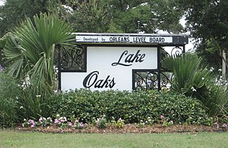
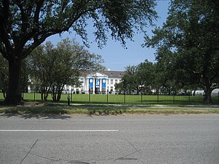
Lake Terrace/Lake Oaks is a neighborhood of the city of New Orleans, Louisiana. A sub-district of the city's Gentilly District, its boundaries as defined by the City Planning Commission are: Lake Pontchartrain to the north; the Industrial Canal to the east; Leon C. Simon Drive, Elysian Fields Avenue, New York Street, the London Avenue Canal, and Allen Toussaint Boulevard to the south; and Bayou St. John to the west. The neighborhood comprises the Lake Terrace and Lake Oaks subdivisions, the principal campus of the University of New Orleans, and the University of New Orleans Research & Technology Park — all built on land reclaimed from Lake Pontchartrain.

<span class="mw-page-title-main">St. Anthony, New Orleans</span> New Orleans Neighborhood in Louisiana, United States

St. Anthony is a neighborhood of the city of New Orleans. A subdistrict of the Gentilly District Area, its boundaries as defined by the City Planning Commission are: New York Street to the north, Elysian Fields Avenue to the east, Mirabeau Avenue to the south and the London Avenue Canal to the west.

<span class="mw-page-title-main">New Orleans Outfall Canals</span> New Orleans drainage canals

There are three outfall canals in New Orleans, Louisiana – the 17th Street, Orleans Avenue and London Avenue canals. These canals are a critical element of New Orleans’ flood control system, serving as drainage conduits for much of the city. There are 13 miles (21 km) of levees and floodwalls that line the sides of the canals. The 17th Street Canal is the largest and most important drainage canal and is capable of conveying more water than the Orleans Avenue and London Avenue Canals combined.

References

Notes

  1. a neighborhood bounded by Mirabeau Ave, London Ave. Canal, Filmore Ave., and Paris Ave.
  2. NCEI. "Storm Events Database".
  3. "New Orleans Regional Transit Authority - Rider Tools". www.norta.com. Retrieved February 1, 2022.
  4. 1 2 3 4 5 6 7 8 9 10 "Gentilly." Rebuilding Together New Orleans.
  5. "New Orleans Division." Federal Bureau of Investigation. Retrieved on June 9, 2015. "2901 Leon C. Simon Boulevard New Orleans, LA 70126"
  6. "Benjamin Franklin High School" (PDF). School Facilities Master Plan for Orleans Parish. New Orleans Public Schools. January 2008. Archived from the original (PDF) on October 12, 2008. Retrieved February 26, 2010.
  7. Chang, Cindy Recovery School District makes long-term building assignments." Times Picayune . Thursday August 5, 2010. Retrieved on August 4, 2012.
  8. "Living with History in New Orleans' Neighborhoods: Gentilly Terrace." (Archived 2011-11-04 at the Wayback Machine ) Preservation Resources Center of New Orleans. p. 2. Retrieved on August 4, 2012.
  9. "Norman Mayer Library re-opens in Gentilly." (Archived 2013-04-12 at archive.today ) WWL-TV . Tuesday March 20, 2012. Retrieved on March 31, 2013.
  10. Sisco, Annette (April 1, 2012). "3 new libraries, destroyed after Katrina, reopen in a week's time". The Times-Picayune . Retrieved December 11, 2016.
  11. 1 2 Krupa, Michelle (August 12, 2009). "Public library rebuilding project set to begin". The Times-Picayune . Retrieved December 11, 2016.
  12. Donze, Frank (March 12, 2012). "New Orleans libraries turn over a new leaf with state-of-the-art buildings". The Times-Picayune . Retrieved December 11, 2016. - See inset image showing the pictures of the libraries that lists the costs and square footage
  13. Bruno, R. Stephanie. "Renovations to New Orleans area libraries bring them into 21st century." The Times-Picayune . June 24, 2011. Retrieved on March 31, 2013.
  14. Percy, Walker (1961). The Moviegoer. New York: Alfred A. Knopf. ISBN   0375701966.

30°00′52″N90°03′38″W / 30.0144°N 90.0605°W / 30.0144; -90.0605