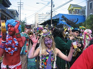
Mardi Gras refers to events of the Carnival celebration, beginning on or after the Christian feasts of the Epiphany and culminating on the day before Ash Wednesday, which is known as Shrove Tuesday. Mardi Gras is French for "Fat Tuesday", reflecting the practice of the last night of eating rich, fatty foods before the ritual Lenten sacrifices and fasting of the Lenten season.

Jefferson Parish is a parish in the U.S. state of Louisiana. As of the 2020 census, the population was 440,781. Its parish seat is Gretna, its largest community is Metairie, and its largest incorporated city is Kenner. Jefferson Parish is included in the Greater New Orleans area.
Gretna is the second-largest city in, and parish seat of, Jefferson Parish in the U.S. state of Louisiana. Gretna lies on the west bank of the Mississippi River, just east and across the river from uptown New Orleans. It is part of the New Orleans–Metairie–Kenner metropolitan statistical area. The population was 17,814 at the 2020 U.S. census.

Harvey is a census-designated place (CDP) in Jefferson Parish, Louisiana, United States. Harvey is on the south side of the Mississippi River, within the New Orleans–Metairie–Kenner metropolitan statistical area. The majority-minority population was 20,348 at the 2010 census, down from 22,226 at the 2000 census. The 2020 census determined 22,236 people lived in the CDP.

The holiday of Mardi Gras is celebrated in southern Louisiana, including the city of New Orleans. Celebrations are concentrated for about two weeks before and through Shrove Tuesday, the day before Ash Wednesday. Mardi Gras is French for Fat Tuesday, the season is known as Carnival and begins on King's Day, January 6(changes yearly with the church calendar), and extends until midnight before Ash Wednesday. Club, or Krewe, balls start soon after, though most are extremely private, with their Kings and Queens coming from wealthy old families and their courts consisting of the season's debutantes. Most of the high society Krewes do not stage parades. As Fat Tuesday gets nearer, the parades start in earnest. Usually there is one major parade each day ; many days have several large parades. The largest and most elaborate parades take place the last five days of the Mardi Gras season. In the final week, many events occur throughout New Orleans and surrounding communities, including parades and balls.

Algiers is a historic neighborhood of New Orleans and is the only Orleans Parish community located on the West Bank of the Mississippi River. Algiers is known as the 15th Ward, one of the 17 Wards of New Orleans. It was once home to many jazz musicians Algiers frequently although dubiously bills itself as the second oldest neighborhood in the city.

Carrollton is a historic neighborhood of Uptown New Orleans, Louisiana, USA, which includes the Carrollton Historic District, recognized by the Historic District Landmark Commission. It is the part of Uptown New Orleans farthest upriver while still being easily accessible to the French Quarter. It was historically a separate town, laid out in 1833 and incorporated on March 10, 1845. Carrollton was annexed by New Orleans in 1874, but it has long retained some elements of distinct identity.

Ernest Nathan "Dutch" Morial, was an American politician and a leading civil rights advocate. He was the first black mayor of New Orleans, serving from 1978 to 1986. He was the father of Marc Morial, who served as Mayor of New Orleans from 1994 to 2002.

Harry Lee was the long-time sheriff of Jefferson Parish, Louisiana. He was first elected in 1979 as the thirtieth sheriff, and was re-elected six times, having served twenty-eight years and six months.

Bywater is a neighborhood of the city of New Orleans. A subdistrict of the Bywater District Area, its boundaries as defined by the City Planning Commission are: Florida Avenue to the north, the Industrial Canal to the east, the Mississippi River to the south, and the railroad tracks along Homer Plessy Way to the west. Bywater is part of the Ninth Ward of New Orleans. It includes part or all of Bywater Historic District, which is listed on the National Register of Historic Places.

John McDonogh was an American entrepreneur whose adult life was spent in south Louisiana and later in Baltimore. He made a fortune in real estate and shipping, and as a slave owner, he supported the American Colonization Society, which organized transportation for freed people of color to Liberia. He had devised a manumission scheme whereby the people he held as enslaved could "buy" their own freedom, which took them some 15 years. In his will he provided large grants for the public education of children of poor whites and freed people of color in New Orleans and Baltimore, and by the 1970s some 20 schools in the New Orleans public school system were named for him.

In New Orleans, Louisiana, United States, downtown has historically referred to neighborhoods along the Mississippi River, downriver from Canal Street – including the French Quarter, Tremé, Faubourg Marigny, Bywater, the 9th Ward, and other neighborhoods. Contrary to the common usage of the term downtown in other cities, this historic application of the term excluded the New Orleans Central Business District. The term continues to be employed as it has been historically, although many younger people and migrants from other parts of the country will use "downtown" as it is used elsewhere; that is, to mean the Central Business District/Warehouse District area.

The Orleans Parish School Board (OPSB) governs the public school system that serves New Orleans, Louisiana. It includes the entirety of Orleans Parish, coterminous with New Orleans.

Uptown is a section of New Orleans, Louisiana, United States, on the east bank of the Mississippi River, encompassing a number of neighborhoods between the French Quarter and the Jefferson Parish line. It remains an area of mixed residential and small commercial properties, with a wealth of 19th-century architecture. It includes part or all of Uptown New Orleans Historic District, which is listed on the National Register of Historic Places.

Jefferson Parish Public Schools is a school district based in Harvey in unincorporated Jefferson Parish, Louisiana, United States. The district operates all district public schools in Jefferson Parish. As of 2019 it had 50,582 students, making it the largest public school system in the state.

U.S. Highway 90 Business is a business route of U.S. Highway 90 located in and near New Orleans, Louisiana. It runs 14.25 miles (22.93 km) in a general east–west direction from US 90 in Avondale to a junction with Interstate 10 (I-10) and US 90 in the New Orleans Central Business District.

Spanish Town is a historic district anchored by Spanish Town Road in Baton Rouge, the capital city of the U.S. state of Louisiana. It is well known for its annual Mardi Gras parade, which is the largest in Baton Rouge.
The Crescent City Connection Division (CCCD) is an agency within the Louisiana Department of Transportation and Development. The purpose of the CCCD is to plan, construct, operate, maintain and police all Mississippi River crossings in Jefferson, Orleans, and St. Bernard Parishes. Prior to the 1989, the CCCD was known as the Mississippi River Bridge Authority (MRBA) and had control of only the Greater New Orleans Bridge (now the Crescent City Connection). The Crescent City Connection Bridge is the fifth busiest bridge in the nation. More than 33 million vehicles traverse the structure annually.

Jean-Bernard Xavier Philippe de Marigny de Mandeville (1785–1868), known as Bernard de Marigny, was a French-Creole American nobleman, playboy, planter, politician, duelist, writer, horse breeder, land developer, and President of the Louisiana State Senate between 1822 and 1823.

Claiborne Avenue is a major thoroughfare in New Orleans, Louisiana. It runs the length of the city, about 9.5 miles (15.3 km), beginning at the Jefferson Parish line and ending at the St. Bernard Parish line; the street continues under different names in both directions. It is called South Claiborne Avenue upriver from Canal Street and North Claiborne Avenue from Canal to St. Bernard Parish.