
Map of ward boundary
The 2nd Ward or Second Ward of New Orleans, Louisiana is one of the 17 Wards of New Orleans. [1]
Contents
The 2nd Ward or Second Ward of New Orleans, Louisiana is one of the 17 Wards of New Orleans. [1]
The Ward fronts the Mississippi River. The down-river or "lower" boundary (in this case, to the northeast) is Julia Street, across which is the 3rd Ward. The boundary continues inland from the end of Julia, originally delineated by the New Basin Canal, now I-10, over the former route of the filled-in canal. The upper boundary is Thalia Street, across which is the 1st Ward, then Martin Luther King Jr. Boulevard (formerly Melpomene Avenue), across from which are portions of the 10th and 11th Wards, then Washington Avenue, across which is the 14th Ward.
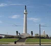
The area along the riverfront was part of the Old Warehouse District. The ward encompasses the upper portion of the New Orleans Central Business District, including Lee Circle, as well as a sliver of the Lower Garden District. Further inland the Ward continues through part of the Central City, including the B.W. Cooper or Calliope housing project.

The Faubourg Marigny is a neighborhood of the city of New Orleans, Louisiana, United States.

The Central Business District (CBD) is a neighborhood of the city of New Orleans, Louisiana, United States.

Bywater is a neighborhood of the city of New Orleans. A subdistrict of the Bywater District Area, its boundaries as defined by the City Planning Commission are: Florida Avenue to the north, the Industrial Canal to the east, the Mississippi River to the south, and the railroad tracks along Homer Plessy Way to the west. Bywater is part of the Ninth Ward of New Orleans. It includes part or all of Bywater Historic District, which is listed on the National Register of Historic Places.

The Ninth Ward or 9th Ward is a distinctive region of New Orleans, Louisiana, which is located in the easternmost downriver portion of the city. It is geographically the largest of the 17 Wards of New Orleans. On the south, the Ninth Ward is bounded by the Mississippi River. On the western or "upriver" side, the Ninth Ward is bounded by Franklin Avenue, then Almonaster Avenue, then People's Avenue. From the north end of People's Avenue the boundary continues on a straight line north to Lake Pontchartrain; this line is the boundary between the Ninth and the city's Eighth Ward. The Lake forms the north and northeastern end of the ward. St. Bernard Parish is the boundary to the southeast, Lake Borgne farther southeast and east, and the end of Orleans Parish to the east at the Rigolets.

The Lower Ninth Ward is a neighborhood in the city of New Orleans, Louisiana. As the name implies, it is part of the 9th Ward of New Orleans. The Lower Ninth Ward is often thought of as the entire area within New Orleans downriver of the Industrial Canal; however, the City Planning Commission divides this area into the Lower Ninth Ward and Holy Cross neighborhoods.

The 8th Ward is a section of New Orleans, Louisiana. It is one of the Downtown Wards of New Orleans, with a Creole history.

The 7th Ward is a section of New Orleans, Louisiana. It is geographically the third largest of the 17 Wards of New Orleans, after the 9th Ward and 15th Ward.

The 17th Ward is one of the 17 Wards of New Orleans, a section of the city of New Orleans, Louisiana. New Orleans Districts and Wards. The 17th Ward, along with the 16th, was formed when the City of New Orleans annexed City of Carrollton in 1870.
The 3rd Ward or Third Ward is one of the 17 Wards of New Orleans, a division of the city of New Orleans, Louisiana.
The 4th Ward or Fourth Ward is a division of the city of New Orleans, Louisiana, United States, one of the 17 Wards of New Orleans.


The 14th Ward or Fourteenth Ward is a section of the city of New Orleans, Louisiana, one of the 17 Wards of New Orleans. The Ward was formed in 1870 from part of Jefferson City and the town of Greenville, which were annexed by New Orleans.


The 10th Ward is a division of the city of New Orleans, Louisiana. The 10th Ward is one of the 17 wards of New Orleans. The ward is one of the city's Uptown wards, formerly the old Faubourg Lafayette annexed by New Orleans in the 1850s.


Rampart Street is a historic avenue located in New Orleans, Louisiana.

St. Charles Avenue is a thoroughfare in New Orleans, Louisiana, U.S. and the route of the St. Charles Streetcar Line. It is also famous for the dozens of mansions that adorn the tree-lined boulevard for much of the uptown section of the boulevard. It is named for St. Charles Borromeo, patron saint of Charles III of Spain, the monarch when France transferred the then-vast territory of Louisiana to Spain at the conclusion of the Seven Years' War in 1763.

Holy Cross is a neighborhood of the city of New Orleans. A subdistrict of the Lower Ninth Ward District Area, its boundaries as defined by the City Planning Commission are: St. Claude Avenue to the north, St. Bernard Parish to the east, the Mississippi River to the south and the Industrial Canal to the west.
| Topics | |
|---|---|
| Government | |
| Colleges and Universities | |
| Sports |
|
| Festivals | |
29°56′46″N90°04′52″W / 29.946°N 90.081°W
| | This New Orleans, Louisiana–related article is a stub. You can help Wikipedia by expanding it. |