
Jefferson Parish is a parish in the U.S. state of Louisiana. As of the 2020 census, the population was 440,781. Its parish seat is Gretna, its largest community is Metairie, and its largest incorporated city is Kenner. Jefferson Parish is included in the Greater New Orleans area.

Central City is a neighborhood of the city of New Orleans. It is located in the 11th Ward of New Orleans in Uptown, just above the Garden District, on the "lakeside" of St. Charles Avenue. A subdistrict of the Central City/Garden District Area, its boundaries as defined by the City Planning Commission are: MLK Boulevard, South Claiborne Avenue and the Pontchartrain Expressway to the north, Magazine, Thalia, Prytania and Felicity Streets and St. Charles Avenue to the south and Toledano Street, Louisiana Avenue and Washington Avenue to the west. This old predominantly African-American neighborhood has been important in the city's brass band and Mardi Gras Indian traditions.

Navarre is a neighborhood of the city of New Orleans. A subdistrict of the Lakeview District Area, its boundaries as defined by the City Planning Commission are: I-610, Canal Boulevard and Florida Boulevard to the north, Orleans Avenue to the east, City Park Avenue to the south and the Pontchartrain Expressway and Pontchartrain Boulevard to the west.
The city planning commission for New Orleans divided the city into 13 planning districts and 73 distinct neighborhoods in 1980. Although initially in the study 68 neighborhoods were designated, and later increased by the City Planning Commission to 76 in October 2001 based in census data, most planners, neighborhood associations, researchers, and journalists have since widely adopted the 73 as the number and can even trace the number back to the early 1900s. While most of these assigned boundaries match with traditional local designations, some others differ from common traditional use. This is a result of the city planning commission's wish to divide the city into sections for governmental planning and zoning purposes without crossing United States census tract boundaries. While most of the listed names have been in common use by New Orleanians for generations, some designated names are rarely heard outside the planning commission's usage.

Lakeview is a neighborhood of the city of New Orleans. A subdistrict of the Lakeview District Area, its boundaries as defined by the City Planning Commission are: Allen Toussaint Boulevard to the north, Orleans Avenue to the east, Florida Boulevard, Canal Boulevard and I-610 to the south and Pontchartrain Boulevard to the west. Lakeview is sometimes used to describe the entire area bounded by Lake Pontchartrain to the north, the Orleans Avenue Canal to the east, City Park Avenue to the south and the 17th Street Canal to the west. This larger definition includes the West End, Lakewood and Navarre neighborhoods, as well as the Lakefront neighborhoods of Lakeshore and Lake Vista.

U.S. Highway 90 Business is a business route of U.S. Highway 90 located in and near New Orleans, Louisiana. It runs 14.25 miles (22.93 km) in a general east–west direction from US 90 in Avondale to a junction with Interstate 10 (I-10) and US 90 in the New Orleans Central Business District.

The Housing Authority of New Orleans is a housing authority in New Orleans, Louisiana, tasked with providing housing to low-income residents.
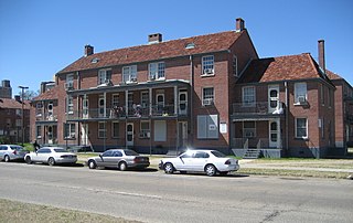
Florida Avenue Projects or Florida Projects is a public housing project in the city of New Orleans. The development was built in 1946 on an 18.5-acre tract of land bounded by Florida Avenue and North Dorgenois, Mazant and Gallier streets in the Upper 9th Ward. It contained 47 two- and three-story brick buildings, arranged around courtyards and largely isolated from the rest of the community, for a total of 734 units housing 1,297 residents. Originally built for whites, it was later desegregated and by the 1970s was becoming predominantly a black project. In the mid-1990s, Florida and nearby Desire Projects were dubbed the most violent housing projects in the nation. In 1994, Florida recorded the highest homicide rate of all HANO developments, with 26 slayings, surpassing the 13 killings in Desire which previous held the highest record a year before. The majority of the Florida killings in 1994 were fueled by drug wars, specifically between the notorious Hardy Boys and the Poonie Crew. The homicide spike in Florida and Desire contributed to New Orleans being dubbed "the nation's murder capital". That year the city's homicide rate reached 424, 47 of those killings occurring in HANO developments.

St. Bernard Projects was a housing project in the city of New Orleans. A subdistrict of the Mid-City District Area, its boundaries as defined by the New Orleans City Planning Commission were: Harrison Avenue to the north, Paris Avenue to the east, Lafreniere Street and Florida Avenue to the south and Bayou St. John to the west.

The Melpomene Projects, officially called the Gustavo Apartments or TheGuste Homes, and colloquially The Melph, are a housing complex located in the Central City neighborhood of New Orleans.
Iberville Projects was a neighborhood in the city of New Orleans and one of the low-income Housing Projects of New Orleans. The Iberville was the last of the New Deal-era public housing remaining in the city. Its boundaries were St. Louis Street, Basin Street, Iberville Street, and North Claiborne Avenue. It is located in the 6th ward of downtown New Orleans, on the former site of the Storyville district. The area has recently been redeveloped into a modernized apartment complex called the Bienville Basin Apartments.

The William J. Fischer Housing Development, better known as the Fischer Projects, was a housing project in Algiers, New Orleans, Louisiana, United States. It was known notoriously for a series of high-profile murders in the 1970s and 1980s. It was the last conventional public housing development constructed in New Orleans, and one of the first to begin demolition. It originally consisted of a 13-floor high-rise and fourteen 3-floor units. The area has been undergoing redevelopment since about 2004 and currently none of the original low-rise buildings remain. The development is located along Whitney Avenue in the Algiers area of the city's west bank, which is part of the 15th Ward and is named for William J. Fischer who served as chairman of HANO in the 1950s. The property is now converted to a small low-income housing development.

Hollygrove is a neighborhood of the city of New Orleans, Louisiana, located in the city's 17th Ward. A subdistrict of the Uptown/Carrollton area, the boundaries as defined by the New Orleans City Planning Commission are the following: Palmetto Street to the north, Cambronne, Edinburgh, Forshey, Fig and Leonidas Streets to the east, Earhart Boulevard to the south and the Jefferson Parish boundary to the west. Conrad playground, the Cuccia-Byrnes playground and Larry Gilbert baseball stadium are located in Hollygrove. The Hollygrove Market and Farm is also located in Hollygrove. Notable people including rapper Lil Wayne have grown up in the neighborhood.

Lower Garden District is a neighborhood of the city of New Orleans. A subdistrict of the Central City/Garden District Area, its boundaries as defined by the New Orleans City Planning Commission are: St. Charles Avenue, Felicity, Prytania, Thalia, Magazine, and Julia Streets to the north; the New Orleans Morial Convention Center, Crescent City Connection, and Mississippi River to the east; Felicity Street, Magazine Street, Constance Street, Jackson Avenue, Chippewa Street, Soraparu Street, and St. Thomas Street to the south; and 1st Street to the west.

Holy Cross is a neighborhood of the city of New Orleans. A subdistrict of the Lower Ninth Ward District Area, its boundaries as defined by the City Planning Commission are: St. Claude Avenue to the north, St. Bernard Parish to the east, the Mississippi River to the south and the Industrial Canal to the west.
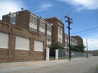
Booker T. Washington High School is a public charter high school in New Orleans, in the U.S. state of Louisiana.
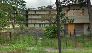
DeGaulle Manor was a federally subsidized public housing complex in the Algiers neighborhood of New Orleans. The apartment complex was known for crime and was one of the oldest and most troubled apartment complexes in the city before being shut down in 2012. It later became a dumping ground for trash and in 2014, became a work of art as it was transformed into a graffiti display.
The D-Block Boys, also known as DBG, was an African-American drug ring operating in Algiers, New Orleans, Louisiana. The gang has been involved in criminal activity including drug trafficking and murder. According to NOPD, The "D-Block Gang" has a history of violations, along with involvement in violent crimes. This gang is not to be confused with the Dumaine Street Gang operating out of the 6th Ward of New Orleans, which is also called D'Block.
The "39ers gang," is a “hybrid” force of the Upper 9th Ward's G-Strip gang and 3-N-G, a notorious Central City drug clan named for its stronghold around Third and Galvez streets. Several of the alleged members also hailed from the Florida housing development. The gangs combined forces in early 2010 to press for control of the heroin trade in both areas, federal prosecutors allege, often through bloodshed against associates of rival gangs, such as "Ride or Die gang" from the 8th Ward of New Orleans and gangs associated with the former Calliope and Desire Projects. The gang is also held accountable for the double 2010 homicide in which the famous rapper Magnolia Shorty was killed. Authorities have connected the 39ers to over 45 murders.
The Metz Gang was a notorious drug ring founded by Glenn Metz and his brother Cordell "Jethro" Metz; Glenn Metz is currently serving life in prison. From 1985 to mid–1992, The Metz Gang distributed approximately 1,000 kilograms of cocaine in the New Orleans metropolitan area and, in furtherance of the conspiracy, committed murders, attempted murders, and other violent crimes. In 1993, Metz, his wife, and several of his henchmen were convicted and charged in a 22 count indictment with various charges arising from a narcotics conspiracy. In 2016, President Barack Obama commuted the life sentence of Danielle Metz, wife of Glenn Metz.


