Interstate 610 (I-610) is a 4.52-mile-long (7.27 km) auxiliary route of I-10 that lies almost entirely within the city limits of New Orleans, Louisiana, bypassing its Central Business District.
The Pontchartrain Expressway is a parallel six-lane section of Interstate 10 (I-10) and U.S. Route 90 Business in New Orleans, Louisiana, USA, with a brief stand-alone section in between junctions with these highways. The designation begins on I-10 near the Orleans–Jefferson parish line at the I-610 Split. The expressway follows I-10 into the Central Business District (CBD) of New Orleans and then follows US 90 Bus. to the Crescent City Connection. The expressway takes its name from Pontchartrain Boulevard, which the expressway replaced in some areas. The Pontchartrain name is derived from Lake Pontchartrain, which New Orleans' northern border traverses.

Central City is a neighborhood of the city of New Orleans. It is located in the 11th Ward of New Orleans in Uptown, just above the Garden District, on the "lakeside" of St. Charles Avenue. A subdistrict of the Central City/Garden District Area, its boundaries as defined by the City Planning Commission are: MLK Boulevard, South Claiborne Avenue and the Pontchartrain Expressway to the north, Magazine, Thalia, Prytania and Felicity Streets and St. Charles Avenue to the south and Toledano Street, Louisiana Avenue and Washington Avenue to the west. This old predominantly African-American neighborhood has been important in the city's brass band and Mardi Gras Indian traditions.

The New Basin Canal, also known as the New Canal and the New Orleans Canal, was a shipping canal in New Orleans, Louisiana, operating from 1830s into the 1940s.

The 17th Ward is one of the 17 Wards of New Orleans, a section of the city of New Orleans, Louisiana. New Orleans Districts and Wards. The 17th Ward, along with the 16th, was formed when the City of New Orleans annexed City of Carrollton in 1870.

Navarre is a neighborhood of the city of New Orleans. A subdistrict of the Lakeview District Area, its boundaries as defined by the City Planning Commission are: I-610, Canal Boulevard and Florida Boulevard to the north, Orleans Avenue to the east, City Park Avenue to the south and the Pontchartrain Expressway and Pontchartrain Boulevard to the west.

Lakeview is a neighborhood of the city of New Orleans. A subdistrict of the Lakeview District Area, its boundaries as defined by the City Planning Commission are: Allen Toussaint Boulevard to the north, Orleans Avenue to the east, Florida Boulevard, Canal Boulevard and I-610 to the south and Pontchartrain Boulevard to the west. Lakeview is sometimes used to describe the entire area bounded by Lake Pontchartrain to the north, the Orleans Avenue Canal to the east, City Park Avenue to the south and the 17th Street Canal to the west. This larger definition includes the West End, Lakewood and Navarre neighborhoods, as well as the Lakefront neighborhoods of Lakeshore and Lake Vista.

U.S. Highway 90 Business is a business route of U.S. Highway 90 located in and near New Orleans, Louisiana. It runs 14.25 miles (22.93 km) in a general east–west direction from US 90 in Avondale to a junction with Interstate 10 (I-10) and US 90 in the New Orleans Central Business District.

The Earhart Expressway, named for former New Orleans Commissioner of Public Utilities, Fred A. Earhart, is a state highway located in both Jefferson Parish and Orleans Parish, Louisiana. It is also designated as Louisiana Highway 3139, spanning a total of 5.2 miles (8.4 km). Although it is an odd-numbered highway and is bannered north/south, it travels in a more east-to-west direction.
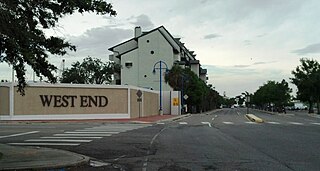
West End is a neighborhood of the city of New Orleans. A subdistrict of the Lakeview District Area, its boundaries as defined by the City Planning Commission are: Lake Pontchartrain to the north, the New Basin Canal and Pontchartrain Boulevard to the east, Veterans Boulevard to the south, and the 17th Street Canal to the west. The area was largely built on land reclaimed from Lake Pontchartrain. It is a commercial seafood and recreational boating hub for the city and has been known for its seafood restaurants. In recent years, the area has seen large condominium-complex developments built which overlook the Lake, marinas, and centrally located 30-acre (120,000 m2) West End Park.

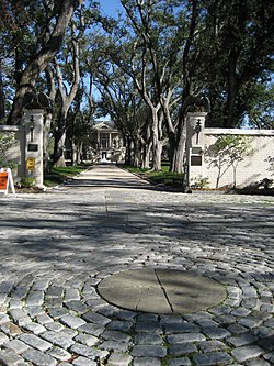
Country Club Gardens is a residential neighborhood in Planning District Five (D5) of New Orleans, Louisiana, in the United States comprising homes along six streets:

Hollygrove is a neighborhood of the city of New Orleans, Louisiana, located in the city's 17th Ward. A subdistrict of the Uptown/Carrollton area, the boundaries as defined by the New Orleans City Planning Commission are the following: Palmetto Street to the north, Cambronne, Edinburgh, Forshey, Fig and Leonidas Streets to the east, Earhart Boulevard to the south and the Jefferson Parish boundary to the west. Conrad playground, the Cuccia-Byrnes playground and Larry Gilbert baseball stadium are located in Hollygrove. The Hollygrove Market and Farm is also located in Hollygrove. Particularly notable people, including rapper Lil Wayne, have grown up in the neighborhood.

Mid-City is a neighborhood of the city of New Orleans. A sub-district of the Mid-City District Area, its boundaries as defined by the New Orleans City Planning Commission are: City Park Avenue, Toulouse Street, North Carrollton, Orleans Avenue, Bayou St. John and St. Louis Street to the north, North Broad Street to the east, and the Pontchartrain Expressway to the west. It is a historic district on the National Register of Historic Places. In common usage, a somewhat larger area surrounding these borders is often also referred to as part of Mid-City.

Louisiana Highway 3046 is a state highway in Louisiana that serves Jefferson Parish. It spans 1.0 mile (1.6 km) in a south to north direction. It is known locally as Causeway Boulevard.

Dixon is a neighborhood of the city of New Orleans. A subdistrict of the Uptown/Carrollton Area, its boundaries as defined by the New Orleans City Planning Commission are: Interstate 10 to the northeast, South Carrollton Avenue to the southeast, Palmetto Street to the southwest and Cherry, Dixon, Mistletoe, Peach, Hamilton, Quince and Last Streets to the northwest.

Tulane/Gravier is a neighborhood of the city of New Orleans, Louisiana, U.S.A. A subdistrict of the Mid-City District Area, its boundaries as defined by the New Orleans City Planning Commission are: St. Louis Street to the north, North Claiborne Avenue, Iberville Street, North and South Derbigny Street, Cleveland Street, South Claiborne Avenue to the east, the Pontchartrain Expressway to the south and South Broad Street to the west.
City Park is a neighborhood of the city of New Orleans, USA. A subdistrict of the Lakeview District Area, its boundaries as defined by the City Planning Commission are: Allen Toussaint Boulevard to the north, Bayou St. John to the east, Orleans Avenue, North Carrollton Avenue and Toulouse Street to the south and City Park and Orleans Avenues to the west. The neighborhood is named after and dominated by City Park.
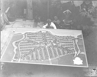
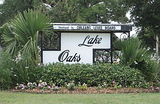
Lakeshore/Lake Vista is a neighborhood of the city of New Orleans, Louisiana. A subdistrict of the Lakeview District Area, its boundaries as defined by the City Planning Commission are: Lake Pontchartrain to the north, Bayou St. John to the east, Allen Toussaint Boulevard to the south and Pontchartrain Boulevard and the New Basin Canal to the west. The neighborhood is composed of the Lakeshore and Lake Vista subdivisions, built on land reclaimed from Lake Pontchartrain. The Lakefront is a term sometimes used to name the larger neighborhood created by the Orleans Levee Board's land reclamation initiative in early 20th century New Orleans; it includes Lakeshore and Lake Vista, as well as Lakeshore Drive and the lakefront park system, the University of New Orleans, Lake Terrace, and Lake Oaks.
Lake Terrace/Lake Oaks is a neighborhood of the city of New Orleans, Louisiana. A sub-district of the city's Gentilly District, its boundaries as defined by the City Planning Commission are: Lake Pontchartrain to the north; the Industrial Canal to the east; Leon C. Simon Drive, Elysian Fields Avenue, New York Street, the London Avenue Canal, and Allen Toussaint Boulevard to the south; and Bayou St. John to the west. The neighborhood comprises the Lake Terrace and Lake Oaks subdivisions, the principal campus of the University of New Orleans, and the University of New Orleans Research & Technology Park — all built on land reclaimed from Lake Pontchartrain.