Lake Pontchartrain is an estuary located in southeastern Louisiana in the United States. It covers an area of 630 square miles (1,600 km2) with an average depth of 12 to 14 feet. Some shipping channels are kept deeper through dredging. It is roughly oval in shape, about 40 miles (64 km) from west to east and 24 miles (39 km) from south to north.
The Pontchartrain Expressway is a parallel six-lane section of Interstate 10 (I-10) and U.S. Route 90 Business in New Orleans, Louisiana, USA, with a brief stand-alone section in between junctions with these highways. The designation begins on I-10 near the Orleans–Jefferson parish line at the I-610 Split. The expressway follows I-10 into the Central Business District (CBD) of New Orleans and then follows US 90 Bus. to the Crescent City Connection. The expressway takes its name from Pontchartrain Boulevard, which the expressway replaced in some areas. The Pontchartrain name is derived from Lake Pontchartrain, which New Orleans' northern border traverses.

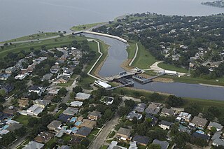
The 17th Street Canal is the largest and most important drainage canal in the city of New Orleans. Operating with Pump Station 6, it moves water into Lake Pontchartrain. The canal, along with the Orleans Canal and the London Avenue Canal, form the New Orleans Outfall Canals. The 17th Street Canal forms a significant portion of the boundary between the city of New Orleans and Metairie, Louisiana. The canal has also been known as the Metairie Outlet Canal and the Upperline Canal.
On Monday, August 29, 2005, there were over 50 failures of the levees and flood walls protecting New Orleans, Louisiana, and its suburbs following passage of Hurricane Katrina. The failures caused flooding in 80% of New Orleans and all of St. Bernard Parish. In New Orleans alone, 134,000 housing units — 70% of all occupied units — suffered damage from Hurricane Katrina and the subsequent flooding.
The Orleans Canal is a drainage canal in New Orleans, Louisiana. The canal, along with the 17th Street Canal and the London Avenue Canal, form the New Orleans Outfall Canals. The current version of the canal is about 2 km long, running along the up-river side of City Park, through the Lakeview and Lakeshore neighborhood, and into Lake Pontchartrain. It is part of the system used to pump rain water out of the streets of the city into the Lake. The Canal has also been known as the Orleans Avenue Canal, the Orleans Outfall Canal, the Orleans Tail Race, and early on, the Girod Canal.

The New Basin Canal, also known as the New Canal and the New Orleans Canal, was a shipping canal in New Orleans, Louisiana, operating from 1830s into the 1940s.

The 17th Ward is one of the 17 Wards of New Orleans, a section of the city of New Orleans, Louisiana. New Orleans Districts and Wards. The 17th Ward, along with the 16th, was formed when the City of New Orleans annexed City of Carrollton in 1870.
The 4th Ward or Fourth Ward is a division of the city of New Orleans, Louisiana, United States, one of the 17 Wards of New Orleans.

Navarre is a neighborhood of the city of New Orleans. A subdistrict of the Lakeview District Area, its boundaries as defined by the City Planning Commission are: I-610, Canal Boulevard and Florida Boulevard to the north, Orleans Avenue to the east, City Park Avenue to the south and the Pontchartrain Expressway and Pontchartrain Boulevard to the west.

Gentilly is a broad, predominantly middle-class and racially diverse section of New Orleans, Louisiana. The Gentilly neighborhood is bounded by Lake Pontchartrain to the north, France Road to the east, Bayou St. John to the west, and CSX Transportation railroad tracks to the south.

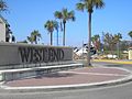
Lakeview is a neighborhood of the city of New Orleans. A subdistrict of the Lakeview District Area, its boundaries as defined by the City Planning Commission are: Allen Toussaint Boulevard to the north, Orleans Avenue to the east, Florida Boulevard, Canal Boulevard and I-610 to the south and Pontchartrain Boulevard to the west. Lakeview is sometimes used to describe the entire area bounded by Lake Pontchartrain to the north, the Orleans Avenue Canal to the east, City Park Avenue to the south and the 17th Street Canal to the west. This larger definition includes the West End, Lakewood and Navarre neighborhoods, as well as the Lakefront neighborhoods of Lakeshore and Lake Vista.
The Southern Yacht Club is located in New Orleans, Louisiana's West End neighborhood, on the shores of Lake Pontchartrain. Established on July 21, 1849, it is the fifth oldest yacht club in the United States and a founding member of the Gulf Yachting Association.

The New Orleans Yacht Club (NOYC) was founded in June 1949 and is dedicated to further the sport of yacht racing, marine safety and seamanship. The club is located at West End's Municipal Yacht Harbor on the south shore of Lake Pontchartrain and is a member of the Gulf Yachting Association since 1953.
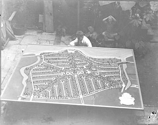
Lakeshore/Lake Vista is a neighborhood of the city of New Orleans, Louisiana. A subdistrict of the Lakeview District Area, its boundaries as defined by the City Planning Commission are: Lake Pontchartrain to the north, Bayou St. John to the east, Allen Toussaint Boulevard to the south and Pontchartrain Boulevard and the New Basin Canal to the west. The neighborhood is composed of the Lakeshore and Lake Vista subdivisions, built on land reclaimed from Lake Pontchartrain. The Lakefront is a term sometimes used to name the larger neighborhood created by the Orleans Levee Board's land reclamation initiative in early 20th century New Orleans; it includes Lakeshore and Lake Vista, as well as Lakeshore Drive and the lakefront park system, the University of New Orleans, Lake Terrace, and Lake Oaks.

Lakewood is a neighborhood of the city of New Orleans. A subdistrict of the Lakeview District Area, its boundaries as defined by the City Planning Commission are: Veterans Memorial Boulevard to the north, Pontchartrain Boulevard and the Pontchartrain Expressway to the east, Last, Quince, Hamilton, Peach, Mistletoe, Dixon, Cherry and Palmetto Streets to the south and the 17th Street Canal to the west.
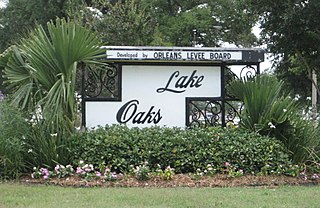
Lake Terrace/Lake Oaks is a neighborhood of the city of New Orleans, Louisiana. A sub-district of the city's Gentilly District, its boundaries as defined by the City Planning Commission are: Lake Pontchartrain to the north; the Industrial Canal to the east; Leon C. Simon Drive, Elysian Fields Avenue, New York Street, the London Avenue Canal, and Allen Toussaint Boulevard to the south; and Bayou St. John to the west. The neighborhood comprises the Lake Terrace and Lake Oaks subdivisions, the principal campus of the University of New Orleans, and the University of New Orleans Research & Technology Park — all built on land reclaimed from Lake Pontchartrain.
The New Canal Light or was first established in 1838 at the north end of the New Basin Canal which ran from Lake Pontchartrain to the Uptown or "American" section of the city which today is known as the New Orleans Central Business District. The canal was filled in about 1950, but the lighthouse remained on a jetty extending into the lake on a half mile long stretch of the canal that was left and is still used as a small boat and yachting harbor.

There are three outfall canals in New Orleans, Louisiana – the 17th Street, Orleans Avenue and London Avenue canals. These canals are a critical element of New Orleans’ flood control system, serving as drainage conduits for much of the city. There are 13 miles (21 km) of levees and floodwalls that line the sides of the canals. The 17th Street Canal is the largest and most important drainage canal and is capable of conveying more water than the Orleans Avenue and London Avenue Canals combined.
The Race to the Coast is the oldest running point-to-point distance sailing regatta and the second oldest regatta in the Western Hemisphere. The first race was held on July 4, 1850, with a course that started on Lake Pontchartrain in New Orleans, Louisiana and finished in Pass Christian, Mississippi. Today the regatta runs from New Orleans to Gulfport, Mississippi and finishes at the Gulfport Yacht Club, where it acts as a feeder regatta for the 100nm Gulport to Pensacola Race and both regattas form the Sawgrass Series. The course has not changed since the inception of the regatta.
Canal Boulevard is located in the Lakeview area of New Orleans, Louisiana. It is a divided roadway that goes from City Park Avenue to Lake Pontchartrain. Canal Boulevard is a prolongation of Canal Street which runs from the Mississippi River to City Park Avenue. As New Orleans expanded, the area of Lakeview was 'reclaimed' cypress swampland. Between 1900 and 1910, the New Orleans Land Company began to drain the area with Canals. These canals are now Milne Street, Canal Boulevard and Argonne Boulevard, as well as Harrison and Florida Avenues. The entire area surrounding Canal Boulevard was inundated with over 10 feet of water during Hurricane Katrina which did not recede for over 3 weeks. Sixteen years later, the boulevard is thriving and has recovered completely.