
A swamp is a forested wetland. Swamps are considered to be transition zones because both land and water play a role in creating this environment. Swamps vary in size and are located all around the world. The water of a swamp may be fresh water, brackish water, or seawater. Freshwater swamps form along large rivers or lakes where they are critically dependent upon rainwater and seasonal flooding to maintain natural water level fluctuations. Saltwater swamps are found along tropical and subtropical coastlines. Some swamps have hammocks, or dry-land protrusions, covered by aquatic vegetation, or vegetation that tolerates periodic inundation or soil saturation. The two main types of swamp are "true" or swamp forests and "transitional" or shrub swamps. In the boreal regions of Canada, the word swamp is colloquially used for what is more formally termed a bog, fen, or muskeg. Some of the world's largest swamps are found along major rivers such as the Amazon, the Mississippi, and the Congo.

Lake Pontchartrain is a brackish estuary located in southeastern Louisiana in the United States. It covers an area of 630 square miles (1,600 km2) with an average depth of 12 to 14 feet. Some shipping channels are kept deeper through dredging. It is roughly oval in shape, about 40 miles (64 km) from west to east and 24 miles (39 km) from south to north.

The Pearl River is a river in the U.S. states of Mississippi and Louisiana. It forms in Neshoba County, Mississippi from the confluence of Nanih Waiya and Tallahaga creeks, and has a meander length of 444 miles (715 km). The lower part of the river forms part of the boundary between Mississippi and Louisiana.

Sabine Lake is a bay on the Gulf coasts of Texas and Louisiana, located approximately 90 miles (140 km) east of Houston and 160 miles (260 km) west of Baton Rouge, adjoining the city of Port Arthur. The lake is formed by the confluence of the Neches and Sabine Rivers and connects to the Gulf of Mexico through Sabine Pass. It forms part of the Texas–Louisiana border, falling within Jefferson and Orange Counties in Texas and Cameron Parish, Louisiana.

The Mississippi River–Gulf Outlet Canal is a 76 mi (122 km) channel constructed by the United States Army Corps of Engineers at the direction of Congress in the mid-20th century that provided a shorter route between the Gulf of Mexico and New Orleans' inner harbor Industrial Canal via the Intracoastal Waterway. In 2005, the MRGO channeled Hurricane Katrina's storm surge into the heart of Greater New Orleans, contributing significantly to the subsequent multiple engineering failures experienced by the region's hurricane protection network. In the aftermath the channel was closed. A permanent storm surge barrier was constructed in the MRGO in 2009, and the channel has been closed to maritime shipping.

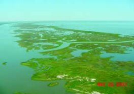
The Mississippi River Delta is the confluence of the Mississippi River with the Gulf of Mexico in Louisiana, southeastern United States. The river delta is a three-million-acre area of land that stretches from Vermilion Bay on the west, to the Chandeleur Islands in the east, on Louisiana's southeastern coast. It is part of the Gulf of Mexico and the Louisiana coastal plain, one of the largest areas of coastal wetlands in the United States. The Mississippi River Delta is the 7th largest river delta on Earth (USGS) and is an important coastal region for the United States, containing more than 2.7 million acres of coastal wetlands and 37% of the estuarine marsh in the conterminous U.S. The coastal area is the nation's largest drainage basin and drains about 41% of the contiguous United States into the Gulf of Mexico at an average rate of 470,000 cubic feet per second.

Lake Maurepas is located in southeastern Louisiana, approximately halfway between New Orleans and Baton Rouge, directly west of Lake Pontchartrain.

Rigolets is a 12.9 kilometer (8 mi) long deepwater strait in Louisiana. "Rigolets" comes from the word rigole, French for 'trench' or 'gutter'. The name is now locally pronounced "RIG-uh-leez".

Hurricane preparedness in New Orleans has been an issue since the city's early settlement because of its location.

The Industrial Canal is a 5.5 mile (9 km) waterway in New Orleans, Louisiana, United States. The waterway's proper name, as used by the U.S. Army Corps of Engineers and on NOAA nautical charts, is Inner Harbor Navigation Canal (IHNC). The more common "Industrial Canal" name is used locally, both by commercial mariners and by landside residents.

The wetlands of Louisiana are water-saturated coastal and swamp regions of southern Louisiana, often called 'Bayou'.
The Atchafalaya Basin, or Atchafalaya Swamp, is the largest wetland and swamp in the United States. Located in south central Louisiana, it is a combination of wetlands and river delta area where the Atchafalaya River and the Gulf of Mexico converge. The river stretches from near Simmesport in the north through parts of eight parishes to the Morgan City southern area.
The Flood Control Act of 1965, Title II of Pub.L. 89–298, was enacted on October 27, 1965, by the 89th Congress and authorized the United States Army Corps of Engineers to design and construct numerous flood control projects including the Lake Pontchartrain and Vicinity, Louisiana Hurricane Protection Project in the New Orleans region of south Louisiana.
Bayou Sauvage National Wildlife Refuge is a 23,000-acre (93 km2) region of fresh and brackish marshes located within the city limits of New Orleans. It is the largest urban wildlife refuge in the United States.

The Coastal Wetlands Planning, Protection and Restoration Act (CWPPRA) was passed by Congress in 1990 to fund wetland enhancement. In cooperation with multiple government agencies, CWPPRA is moving forward to restore the lost wetlands of the Gulf Coast as well as protecting the wetlands from future deterioration. The scope of the mission is not simply for the restoration of Louisiana's Wetlands, but also the research and implementation of preventative measures for wetlands preservation.

There are three outfall canals in New Orleans, Louisiana – the 17th Street, Orleans Avenue and London Avenue canals. These canals are a critical element of New Orleans’ flood control system, serving as drainage conduits for much of the city. There are 13 miles (21 km) of levees and floodwalls that line the sides of the canals. The 17th Street Canal is the largest and most important drainage canal and is capable of conveying more water than the Orleans Avenue and London Avenue Canals combined.
Fritchie Marsh is an area encompassing 6,291 acres of intermediate and brackish marsh located approximately three miles to the southeast of Slidell, Louisiana, USA. This wetland was originally documented as a freshwater marsh but has since been converted to a mixed intermediate and brackish marsh, and it threatens to become open salt water. Through the combined efforts of conservation groups and sponsors, the Fritchie Marsh Restoration Project was created and designed to restore the area to its original state. In the early years, this project showed a positive impact but soon suffered a devastating impact during Hurricane Katrina.

The effects of Hurricane Isaac in Louisiana were more severe than anywhere in the storm's path, and included $611.8615 million in damages and five total deaths. Forming from a tropical wave in the central Atlantic, Isaac traversed across many of the Lesser and Greater Antilles, before reaching peak intensity with winds of 80 mph (130 km/h) on August 28, 2012 while in the Gulf of Mexico. Nearing the coast of Louisiana, the Category 1 hurricane slowly moved towards the west, making two landfalls in the state with little change of intensity prior to moving inland for a final time. The hurricane weakened and later dissipated on September 1 while over Missouri. Before landfall, Governor Bobby Jindal declared a state of emergency to the state, as well as ordering the mandatory evacuation of 60,000 residents in low-lying areas of Louisiana along the Tangipahoa River in Tangipahoa Parish.

Coastal Erosion in Louisiana is the process of steady depletion of wetlands along the state's coastline in marshes, swamps, and barrier islands, particularly affecting the alluvial basin surrounding the mouth of the Mississippi River at the foot of the Gulf of Mexico on the Eastern half of the state's coast. In the last century, Southeast Louisiana has lost a large portion of its wetlands and is expected to lose more in the coming years, with some estimates claiming wetland losses equivalent to up to 1 football field per hour. One consequence of coastal erosion is an increased vulnerability to hurricane storm surges, which affects the New Orleans metropolitan area and other communities in the region. The state has outlined a comprehensive master plan for coastal restoration and has begun to implement various restoration projects such as fresh water diversions, but certain zones will have to be prioritized and targeted for restoration efforts, as it is unlikely that all depleted wetlands can be rehabilitated.
Biloxi Wildlife Management Area, also referred to as Biloxi WMA, is a 42,747 acre privately owned tract of protected marsh land located in St. Bernard Parish, Louisiana, managed by the Louisiana Department of Wildlife and Fisheries (LDWF). The land is owned by Biloxi Marsh Lands Corporation, owning approximately 90,000 acres (36,000 ha) of land in St. Bernard Parish, that started leasing land to the LDWF as early as 1957. Access is limited to boats as there are no roads in the WMA. The nearest road access is LA 46 to Shell Beach or LA 624 to Hopedale.

![Lake Borgne [right center] is southeast of Lake Pontchartrain and east of New Orleans, Louisiana. National Atlas Louisiana east detailed.gif](http://upload.wikimedia.org/wikipedia/commons/thumb/9/9a/National_Atlas_Louisiana_east_detailed.gif/330px-National_Atlas_Louisiana_east_detailed.gif)
