
St. Tammany Parish is a parish located in the U.S. state of Louisiana named after Tamanend, a Principle Lenape Chief considered the "Patron Saint of America." Although not a saint of the Roman Catholic Church, George Washington held him in higher esteem than Roman Catholic Saints. Even qualifying him as divine and possessing moral perfection. As of the 2010 census, the population was 233,740, making it the fifth-most populous parish in Louisiana. The parish seat is Covington. The parish was founded in 1810.

Lake Pontchartrain is a brackish estuary located in southeastern Louisiana in the United States. It covers an area of 630 square miles (1,600 km2) with an average depth of 12 to 14 feet. Some shipping channels are kept deeper through dredging. It is roughly oval in shape, about 40 miles (64 km) from west to east and 24 miles (39 km) from south to north.

U.S. Route 90 or U.S. Highway 90 is an east–west major United States highway in the Southern United States. Despite the "0" in its route number, US 90 never was a full coast-to-coast route. With the exception of a short-lived northward extension to US 62/US 180 near Pine Springs, Texas that existed for less than one year, its western terminus has always been at Van Horn, Texas; currently, this is an intersection with Interstate 10 Business just north of an interchange with Interstate 10. Its eastern terminus is at Florida State Road A1A in Jacksonville Beach, Florida, three blocks from the Atlantic Ocean.

Lake Borgne is a lagoon of the Gulf of Mexico in southeastern Louisiana. Although early maps show it as a lake surrounded by land, coastal erosion has made it an arm of the Gulf of Mexico. Its name comes from the French word borgne, which means "one-eyed."

The Ninth Ward or 9th Ward is a distinctive region of New Orleans, Louisiana, which is located in the easternmost downriver portion of the city. It is geographically the largest of the 17 Wards of New Orleans. On the south, the Ninth Ward is bounded by the Mississippi River. On the western or "upriver" side, the Ninth Ward is bounded by Franklin Avenue, then Almonaster Avenue, then People's Avenue. From the north end of People's Avenue the boundary continues on a straight line north to Lake Pontchartrain; this line is the boundary between the Ninth and the city's Eighth Ward. The Lake forms the north and northeastern end of the ward. St. Bernard Parish is the boundary to the southeast, Lake Borgne farther southeast and east, and the end of Orleans Parish to the east at the Rigolets.

The Rigolets is a 12.9 kilometer (8 mi) long deepwater strait in Louisiana. "Rigolets" comes from the word rigole, French for "trench" or "gutter." The name is now locally pronounced "RIG-uh-leez."
The article covers the Hurricane Katrina effects by region, within the United States and Canada. The effects of Hurricane Katrina, in August 2005, were catastrophic and widespread. It was one of the deadliest natural disasters in U.S. history, leaving at least 1,836 people dead, and a further 135 missing. The storm was large and had an effect on several different areas of North America.

The Industrial Canal is a 5.5 mile (9 km) waterway in New Orleans, Louisiana, United States. The waterway's proper name, as used by the U.S. Army Corps of Engineers and on NOAA nautical charts, is Inner Harbor Navigation Canal (IHNC). The more common "Industrial Canal" name is used locally, both by commercial mariners and by landside residents.
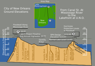
Drainage in New Orleans, Louisiana, has been a major concern since the founding of the city in the early 18th century, remaining an important factor in the history of New Orleans today. The central portion of metropolitan New Orleans is fairly unusual in that it is almost completely surrounded by water: Lake Pontchartrain to the north, Lake Borgne to the east, wetlands to the east and west, and the Mississippi River to the south. Half of the land area between these bodies of water is at or below sea level, and no longer has a natural outlet for flowing surface water. As such, virtually all rainfall occurring within this area must be removed through either evapotranspiration or pumping. Thus, flood threats to metropolitan New Orleans include the Mississippi River, Lake Pontchartrain, and natural rainfall. Artificial levees have been built to keep out rising river and lake waters but have had the negative effect of keeping rainfall in.
"The Lakes of Pontchartrain" is a ballad from the United States about a man who is given shelter by a Louisiana Creole woman. He falls in love with her and asks her to marry him, but she is already promised to a sailor and declines.
The Chef Menteur Pass is a narrow natural waterway which, along with the Rigolets, connects Lake Pontchartrain and Lake Borgne in New Orleans, Louisiana. It begins at 30°5′45″N89°48′52″W and follows a generally southeastward course.

Fort Macomb is a 19th-century United States brick fort in Louisiana, on the western shore of Chef Menteur Pass. It is listed on the National Register of Historic Places. The fort is adjacent to the Venetian Isles community, now legally within the city limits of New Orleans, Louisiana. This community was some miles distant from the city when first built and is still distant from the main developed portion of the city.

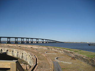
Fort Pike State Historic Site is a decommissioned 19th-century United States fort, named after Brigadier General Zebulon Pike. It was built following the War of 1812 to guard the Rigolets pass in Louisiana, a strait from the Gulf of Mexico, via Lake Borgne, to Lake Pontchartrain bordering New Orleans. It was located near the community of Petite Coquille, now within the city limits of New Orleans.

Gentilly is a broad, predominantly middle-class and racially diverse section of New Orleans, Louisiana. The Gentilly neighborhood is bounded by Lake Pontchartrain to the north, France Road to the east, Bayou St. John to the west, and the Louisville and Nashville Railroad to the south.

The eastern section of New Orleans, colloquially known as "New Orleans East" or simply "The East," is the newest section of the city. Eastern New Orleans is bounded by the Industrial Canal, the Intracoastal Waterway and Lake Pontchartrain. Developed extensively from the 1950s onward, its numerous residential subdivisions and shopping centers offered suburban-style living within the city limits of New Orleans. Its overall character is today decidedly suburban, resembling the archetypal postwar American suburb much more than the compactly-built environment found in the city's historic core.

U.S. Highway 90 (US 90), one of the major east–west U.S. Highways in the Southern United States, runs through southern Louisiana for 297.6 miles (478.9 km), serving Lake Charles, Lafayette, New Iberia, Morgan City, and New Orleans. Much of it west of Lafayette and east of New Orleans has been supplanted by Interstate 10 (I-10) for all but local traffic, but the section between Lafayette and New Orleans runs a good deal south of I-10.
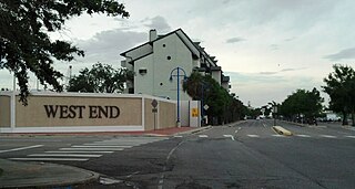
West End is a neighborhood of the city of New Orleans. A subdistrict of the Lakeview District Area, its boundaries as defined by the City Planning Commission are: Lake Pontchartrain to the north, the New Basin Canal and Pontchartrain Boulevard to the east, Veterans Boulevard to the south, and the 17th Street Canal to the west. The area was largely built on land reclaimed from Lake Pontchartrain. It is a commercial seafood and recreational boating hub for the city and has been known for its seafood restaurants. In recent years, the area has seen large condominium-complex developments built which overlook the Lake, marinas, and centrally located 30-acre (120,000 m2) West End Park.
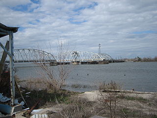
The Fort Pike Bridge carries U.S. Route 90 across the Rigolets on the eastern side of Lake Pontchartrain between New Orleans and Slidell in Louisiana. It is owned and operated by Louisiana Department of Transportation and Development The bridge opened on June 9, 1930, and along with the Chef Menteur Bridge provided a free route between New Orleans and the Mississippi Gulf Coast. This was the site of Jayne Mansfield's death in June 1967. A new span was constructed just to the north of the old span.
The Maestri Bridge carries U.S. Route 11 (US 11) across Lake Pontchartrain between New Orleans and Slidell, Louisiana, in the United States.
SS Alice McGuigin was a two-masted schooner that sank in Lake Borgne off Pearlington, Mississippi, United States in the 1893 Cheniere Caminada hurricane. Under the command of Captain Wm. Delavier with five crewmembers, the schooner was owned by the Poitevent & Favre Lumber Company before lost at sea on October 2, 1893.


