
Madisonville is a town in St. Tammany Parish in the U.S. state of Louisiana. The population was 748 at the 2010 U.S. census, and 857 at the 2020 U.S. population estimates program. It is part of the New Orleans–Metairie–Kenner metropolitan statistical area. The ZIP code is 70447.

Lake Pontchartrain is a brackish estuary located in southeastern Louisiana in the United States. It covers an area of 630 square miles (1,600 km2) with an average depth of 12 to 14 feet. Some shipping channels are kept deeper through dredging. It is roughly oval in shape, about 40 miles (64 km) from west to east and 24 miles (39 km) from south to north.

The Sabine Pass Lighthouse, or Sabine Pass Light as it was referred to by the United States Coast Guard, is a historic lighthouse, as part of a gulf coast light station, on the Louisiana side of the Sabine River, in Cameron Parish, across from the community of Sabine Pass, Texas. It was first lit in 1857 and was deactivated by the Coast Guard in 1952. One of only three built in the United States of similar design, the light was listed on the National Register of Historic Places as "Sabine Pass Lighthouse" on December 17, 1981. It is now abandoned but has long continued to be the subject of preservation efforts.

Rigolets is a 12.9 kilometer (8 mi) long deepwater strait in Louisiana. "Rigolets" comes from the word rigole, French for 'trench' or 'gutter'. The name is now locally pronounced "RIG-uh-leez".

The London Avenue Canal is a drainage canal in New Orleans, Louisiana, used for pumping rain water into Lake Pontchartrain. The canal runs through the 7th Ward of New Orleans from the Gentilly area to the Lakefront. It is one of the three main drainage canals responsible for draining rainwater from the main basin of New Orleans. The London Avenue Canal's flood walls built atop earthen levees breached on both sides during Hurricane Katrina in 2005.

Though Hurricane Katrina did not deal the city of New Orleans a direct hit on August 29, 2005, the associated storm surge precipitated catastrophic failures of the levees and flood walls. The Mississippi River Gulf Outlet ("MR-GO") breached its levees in approximately 15 places. The major levee breaches in the city include the 17th Street Canal levee, the London Avenue Canal, and the wide, navigable Industrial Canal, which left approximately 80% of the city flooded.

The Tchefuncte River drains into Lake Pontchartrain in Louisiana in the United States. It is about 70.0 miles (112.7 km) long.
Drainage in New Orleans, Louisiana, has been a major concern since the founding of the city in the early 18th century, remaining an important factor in the history of New Orleans today. The central portion of metropolitan New Orleans is fairly unusual in that it is almost completely surrounded by water: Lake Pontchartrain to the north, Lake Borgne to the east, wetlands to the east and west, and the Mississippi River to the south. Half of the land area between these bodies of water is at or below sea level, and no longer has a natural outlet for flowing surface water. As such, virtually all rainfall occurring within this area must be removed through either evapotranspiration or pumping. Thus, flood threats to metropolitan New Orleans include the Mississippi River, Lake Pontchartrain, canals throughout the city, and natural rainfall. Artificial levees have been built to keep out rising river and lake waters but have had the negative effect of keeping rainfall in, and have failed on numerous occasions.

The New Basin Canal, also known as the New Canal and the New Orleans Canal, is a shipping canal in New Orleans, Louisiana, operating from 1830s into the 1940s.
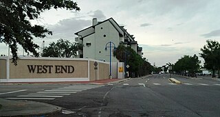
West End is a neighborhood of the city of New Orleans. A subdistrict of the Lakeview District Area, its boundaries as defined by the City Planning Commission are: Lake Pontchartrain to the north, the New Basin Canal and Pontchartrain Boulevard to the east, Veterans Boulevard to the south, and the 17th Street Canal to the west. The area was largely built on land reclaimed from Lake Pontchartrain. It is a commercial seafood and recreational boating hub for the city and has been known for its seafood restaurants. In recent years, the area has seen large condominium-complex developments built which overlook the Lake, marinas, and centrally located 30-acre (120,000 m2) West End Park.

Buffalo (Main) Light is a lighthouse at the mouth of Buffalo River/Erie Canal, directly across from the Erie Basin Marina in Buffalo, New York.
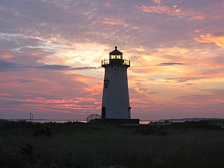
Edgartown Harbor Light is a lighthouse located in Edgartown, Massachusetts, United States, where it marks the entrance to Edgartown Harbor and Katama Bay. It is one of five lighthouses on the island of Martha's Vineyard. The first lighthouse, a two-story wooden structure that also served as the keeper's house, was constructed in 1828. It was demolished, and replaced by the current cast-iron tower, in 1939. Originally located on an artificial island 1/4 miles from shore, the lighthouse is now surrounded by a beach formed, since 1939, by sand accumulating around the stone causeway connecting it to the mainland.

Ship Island Light was a lighthouse in Mississippi near Gulfport.

The Tchefuncte River Range Lights are a range that was first established in 1838 to aid vessels entering the Tchefuncte River from the north side of Lake Pontchartrain, Louisiana. The lighting apparatus was supplied by Winslow Lewis and consisted of nine lamps with several fourteen-inch reflectors. The original rear tower suffered during the Civil War and was replaced with the current tower in 1868. The new tower, ten feet taller than the first, was built on the same foundation, using some of the same brick. It was given a lantern which had been removed from Cat Island Light in Mississippi.

The Chandeleur Island Light was a lighthouse established in 1848 near the northern end of the Chandeleur Islands in the Gulf of Mexico, off the east coast of Louisiana. Hurricane Katrina destroyed the light in 2005.

Pass Manchac Light was a historic lighthouse in Tangipahoa Parish, Louisiana, which was originally established in 1838, to mark the north side of the entrance to Pass Manchac, the channel between Lake Pontchartrain and Lake Maurepas. The fourth and last tower on this particular site was constructed in 1857 and was in service for 130 years. The first three had been built in 1838, 1842, and 1846, in each case requiring replacement due to poor construction and/or encroaching lake waters.

There are three outfall canals in New Orleans, Louisiana – the 17th Street, Orleans Avenue and London Avenue canals. These canals are a critical element of New Orleans’ flood control system, serving as drainage conduits for much of the city. There are 13 miles (21 km) of levees and floodwalls that line the sides of the canals. The 17th Street Canal is the largest and most important drainage canal and is capable of conveying more water than the Orleans Avenue and London Avenue Canals combined.

The Duluth South Breakwater Outer Light is a lighthouse on the south breakwater of the Duluth Ship Canal in Duluth, Minnesota, United States. It forms a range with the Duluth South Breakwater Inner Light to guide ships into the canal from Lake Superior.

The West Rigolets Light was a lighthouse which stood at the west end of the Rigolets where the channel meets Lake Pontchartrain. Built in 1855, it was deactivated sometime around World War II and was destroyed by Hurricane Katrina in 2005.

The Pass A L'Outre Light is a defunct lighthouse in the Birdfoot Delta in Louisiana, United States, located near the mouth of the Mississippi River. Erected to mark the then-active entrance to the river, it was abandoned as that channel silted up. It has been in the path of several noteworthy hurricanes, and was heavily damaged. It is on the Lighthouse Digest Doomsday List, and is critically in danger. The lighthouse is at the center of a nature preserve.
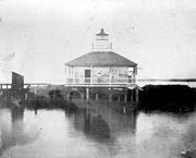 The 1855 Lighthouse
 The 1890/1901 Lighthouse
 Damage after Hurricanes Katrina and Rita - 2005
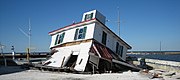 Collapse after Hurricanes Katrina and Rita - 2005


