This article needs additional citations for verification .(August 2023) |

Map of ward boundary
The 4th Ward or Fourth Ward is a division of the city of New Orleans, Louisiana, United States, one of the 17 Wards of New Orleans. [1]
This article needs additional citations for verification .(August 2023) |
The 4th Ward or Fourth Ward is a division of the city of New Orleans, Louisiana, United States, one of the 17 Wards of New Orleans. [1]
The 4th Ward stretches through the city from the Mississippi River to Lake Pontchartrain. [2] From the Mississippi River to Metairie Ridge, the upper boundary is Canal Street, New Orleans, across which is the 3rd Ward, and the lower boundary is St. Louis Street, across which is the 5th Ward. This portion was the original 4th Ward as defined in 1852. [1] [3] In 1880, additional ground (still mostly undeveloped swamp at the time) was added to the Ward from City Park Avenue on Metairie Ridge back to the lake. The upper boundary was the New Basin Canal, now Pontchartrain Boulevard, across which is the 17th Ward. The lower boundary is the Orleans Canal, across which is more of the 5th Ward.

Going roughly from the Mississippi River to Lake Pontchartrain, the Ward has a portion of the riverfront Woldenberg Park, and the old Bienville Street Wharf, formerly a commercial wharf and now a dock for pleasure cruises of tourist steamboats. [4] The Aquarium of the Americas is near the foot of Canal Street. [5] The next blocks back include such notable businesses as the New Orleans House of Blues and the Canal Place skyscraper shopping mall/hotel/theater complex. [6] Across Decatur Street, the Ward includes a 4 by 6 block section of the old French Quarter, including the old U.S. Customs House and some of the most popular businesses on Royal Street and Bourbon Street, some of the blocks most frequented by out-of-town visitors to the city. [7] Across Rampart, near where one of the city's main railroad stations was in the 19th and early 20th century, is the Saenger Theater, a movie & vaudeville palace where touring Broadway shows and other national acts appeared at in the 21st century. In the late 19th and early 20th century Storyville, is the famous red-light district. [8] In the 1940s most of it was torn down to build the Iberville Projects. [8] Continuing back, Mercy Hospital is near the headwaters of Bayou St. John. The Ward includes a narrow strip of Mid-City New Orleans, including some of the neighborhood's best known restaurants. Beyond City Park Avenue (formerly Bayou Metairie Road) the Ward widens out from I-10 to City Park, including Delgado Community College and Greenwood Cemetery, and the Navarre neighborhood, including the studios of PBS television station WYES-12. [9] [10] Farther back is the prosperous Lakeview neighborhood with the commercial strip of Harrison Avenue, and across Allen Toussaint Boulevard the Lakeshore neighborhood, and at the northern end is Lakeshore Park along the lakefront.
Hurricane Katrina heavily impacted much of the Ward. [11] Lakeview is only some dozen blocks from the notorious breach in the 17th Street Canal. [12] [13] Narrow strips of land at the two ends of the Ward, in the French Quarter by the Riverfront and on some of the higher ground of the Lakeshore, were above the flood waters. [14] Some of the narrow strip of Metairie Ridge took on only minimal water. Most of the rest of the ward flooded significantly, often severely. [11] [13]

Metairie is a census-designated place (CDP) in Jefferson Parish, Louisiana, United States, and is part of the New Orleans metropolitan area. With a population of 143,507 in 2020, Metairie is the largest community in Jefferson Parish and was the fifth-largest CDP in the United States. It is an unincorporated area that would have been Louisiana's fourth-largest city behind Shreveport if incorporated.

Lake Pontchartrain is an estuary located in southeastern Louisiana in the United States. It covers an area of 630 square miles (1,600 km2) with an average depth of 12 to 14 feet. Some shipping channels are kept deeper through dredging. It is roughly oval in shape, about 40 miles (64 km) from west to east and 24 miles (39 km) from south to north.

The Ninth Ward or 9th Ward is a distinctive region of New Orleans, Louisiana, which is located in the easternmost downriver portion of the city. It is geographically the largest of the 17 Wards of New Orleans. On the south, the Ninth Ward is bounded by the Mississippi River. On the western or "upriver" side, the Ninth Ward is bounded by Franklin Avenue, then Almonaster Avenue, then People's Avenue. From the north end of People's Avenue the boundary continues on a straight line north to Lake Pontchartrain; this line is the boundary between the Ninth and the city's Eighth Ward. The Lake forms the north and northeastern end of the ward. St. Bernard Parish is the boundary to the southeast, Lake Borgne farther southeast and east, and the end of Orleans Parish to the east at the Rigolets.

The Industrial Canal is a 5.5 mile (9 km) waterway in New Orleans, Louisiana, United States. The waterway's proper name, as used by the U.S. Army Corps of Engineers and on NOAA nautical charts, is Inner Harbor Navigation Canal (IHNC). The more common "Industrial Canal" name is used locally, both by commercial mariners and by landside residents.

The 17th Street Canal is the largest and most important drainage canal in the city of New Orleans. Operating with Pump Station 6, it moves water into Lake Pontchartrain. The canal, along with the Orleans Canal and the London Avenue Canal, form the New Orleans Outfall Canals. The 17th Street Canal forms a significant portion of the boundary between the city of New Orleans and Metairie, Louisiana. The canal has also been known as the Metairie Outlet Canal and the Upperline Canal.

Audubon Aquarium is an aquarium in New Orleans, Louisiana, United States. It reopened with new exhibits and experiences on June 8, 2023.
The Audubon Nature Institute is a family of museums and parks dedicated to nature based in New Orleans, Louisiana.
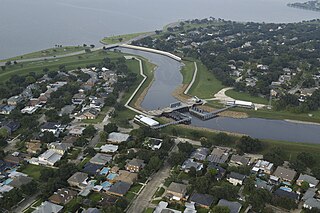
The Orleans Canal is a drainage canal in New Orleans, Louisiana. The canal, along with the 17th Street Canal and the London Avenue Canal, form the New Orleans Outfall Canals. The current version of the canal is about 2 km long, running along the up-river side of City Park, through the Lakeview and Lakeshore neighborhood, and into Lake Pontchartrain. It is part of the system used to pump rain water out of the streets of the city into the Lake. The Canal has also been known as the Orleans Avenue Canal, the Orleans Outfall Canal, the Orleans Tail Race, and early on, the Girod Canal.

The 17th Ward is one of the 17 Wards of New Orleans, a section of the city of New Orleans, Louisiana. New Orleans Districts and Wards. The 17th Ward, along with the 16th, was formed when the City of New Orleans annexed City of Carrollton in 1870.
The 3rd Ward or Third Ward is one of the 17 Wards of New Orleans, a division of the city of New Orleans, Louisiana.

Navarre is a neighborhood of the city of New Orleans. A subdistrict of the Lakeview District Area, its boundaries as defined by the City Planning Commission are: I-610, Canal Boulevard and Florida Boulevard to the north, Orleans Avenue to the east, City Park Avenue to the south and the Pontchartrain Expressway and Pontchartrain Boulevard to the west.


Gentilly is a broad, predominantly middle-class and racially diverse section of New Orleans, Louisiana. The Gentilly neighborhood is bounded by Lake Pontchartrain to the north, France Road to the east, Bayou St. John to the west, and CSX Transportation railroad tracks to the south.

Lakeview is a neighborhood of the city of New Orleans. A subdistrict of the Lakeview District Area, its boundaries as defined by the City Planning Commission are: Allen Toussaint Boulevard to the north, Orleans Avenue to the east, Florida Boulevard, Canal Boulevard and I-610 to the south and Pontchartrain Boulevard to the west. Lakeview is sometimes used to describe the entire area bounded by Lake Pontchartrain to the north, the Orleans Avenue Canal to the east, City Park Avenue to the south and the 17th Street Canal to the west. This larger definition includes the West End, Lakewood and Navarre neighborhoods, as well as the Lakefront neighborhoods of Lakeshore and Lake Vista.

New Orleans East is the eastern section of New Orleans, Louisiana, the newest section of the city. This collection of diverse suburban neighborhoods represents 65% of the city's total land area, but it is geographically isolated from the rest of the city by the Inner Harbor Navigational Canal. It is surrounded by water on all sides, bounded by the Industrial Canal, Gulf Intracoastal Waterway, Lake Pontchartrain, Lake Borgne, and the Rigolets, a long deep-water strait connecting the two lakes. Interstate 10 (I-10) splits the area nearly in half, and Chef Menteur Hwy, Downman Rd, Crowder Blvd, Dwyer Rd, Lake Forest Blvd, Read Blvd, Bullard Ave, Michoud Blvd, Hayne Blvd, Morrison Rd, Bundy Rd, and Almonaster Ave serve as major streets and corridors.

The Canal Streetcar Line is a historic streetcar line in New Orleans, Louisiana. It is operated by the New Orleans Regional Transit Authority (RTA). It originally operated from 1861 to 1964. It was redesigned and rebuilt between 2000 and 2004, and operation was reinstated in 2004 after a 40-year hiatus. Primarily running along its namesake street, Canal Street, it consists of two branches named for their outer terminals, totaling about 5+1⁄2 miles (8.9 km) in length: "Canal–Cemeteries" and "Canal–City Park/Museum". Each branch is denoted with the red and light green colors respectively on most RTA publications.

Mid-City is a neighborhood of the city of New Orleans. A sub-district of the Mid-City District Area, its boundaries as defined by the New Orleans City Planning Commission are: City Park Avenue, Toulouse Street, North Carrollton, Orleans Avenue, Bayou St. John and St. Louis Street to the north, North Broad Street to the east, and the Pontchartrain Expressway to the west. It is a historic district on the National Register of Historic Places. In common usage, a somewhat larger area surrounding these borders is often also referred to as part of Mid-City.
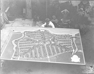
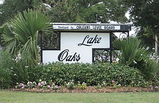
Lakeshore/Lake Vista is a neighborhood of the city of New Orleans, Louisiana. A subdistrict of the Lakeview District Area, its boundaries as defined by the City Planning Commission are: Lake Pontchartrain to the north, Bayou St. John to the east, Allen Toussaint Boulevard to the south and Pontchartrain Boulevard and the New Basin Canal to the west. The neighborhood is composed of the Lakeshore and Lake Vista subdivisions, built on land reclaimed from Lake Pontchartrain. The Lakefront is a term sometimes used to name the larger neighborhood created by the Orleans Levee Board's land reclamation initiative in early 20th century New Orleans; it includes Lakeshore and Lake Vista, as well as Lakeshore Drive and the lakefront park system, the University of New Orleans, Lake Terrace, and Lake Oaks.

Lakewood is a neighborhood of the city of New Orleans. A subdistrict of the Lakeview District Area, its boundaries as defined by the City Planning Commission are: Veterans Memorial Boulevard to the north, Pontchartrain Boulevard and the Pontchartrain Expressway to the east, Last, Quince, Hamilton, Peach, Mistletoe, Dixon, Cherry and Palmetto Streets to the south and the 17th Street Canal to the west.
Lake Terrace/Lake Oaks is a neighborhood of the city of New Orleans, Louisiana. A sub-district of the city's Gentilly District, its boundaries as defined by the City Planning Commission are: Lake Pontchartrain to the north; the Industrial Canal to the east; Leon C. Simon Drive, Elysian Fields Avenue, New York Street, the London Avenue Canal, and Allen Toussaint Boulevard to the south; and Bayou St. John to the west. The neighborhood comprises the Lake Terrace and Lake Oaks subdivisions, the principal campus of the University of New Orleans, and the University of New Orleans Research & Technology Park — all built on land reclaimed from Lake Pontchartrain.
Wards and neighborhoods of Orleans Parish/New Orleans, Louisiana | ||||||||||||||||||||||||||||||||||
|---|---|---|---|---|---|---|---|---|---|---|---|---|---|---|---|---|---|---|---|---|---|---|---|---|---|---|---|---|---|---|---|---|---|---|
| Neighborhoods |
|  | ||||||||||||||||||||||||||||||||
| Wards | ||||||||||||||||||||||||||||||||||
| Footnotes | Orleans Parish and the City of New Orleans are coextensive. ‡This populated place also has portions in an adjacent parish or parishes. | |||||||||||||||||||||||||||||||||