
Lake Pontchartrain is an estuary located in southeastern Louisiana in the United States. It covers an area of 630 square miles (1,600 km2) with an average depth of 12 to 14 feet. Some shipping channels are kept deeper through dredging. It is roughly oval in shape, about 40 miles (64 km) from west to east and 24 miles (39 km) from south to north.

Streetcars in New Orleans have been an integral part of the city's public transportation network since the first half of the 19th century. The longest of New Orleans' streetcar lines, the St. Charles Avenue line, is the oldest continuously operating street railway system in the world. Today, the streetcars are operated by the New Orleans Regional Transit Authority (RTA).

Tremé is a neighborhood in New Orleans, Louisiana. "Tremé" is often rendered as Treme, and the neighborhood is sometimes called by its more formal French name, the Faubourg Tremé; it is listed in the New Orleans City Planning Districts as Tremé / Lafitte when including the Lafitte Projects.

The history of New Orleans, Louisiana traces the city's development from its founding by the French in 1718 through its period of Spanish control, then briefly back to French rule before being acquired by the United States in the Louisiana Purchase in 1803. During the War of 1812, the last major battle was the Battle of New Orleans in 1815. Throughout the 19th century, New Orleans was the largest port in the Southern United States, exporting most of the nation's cotton output and other farm products to Western Europe and New England. As the largest city in the South at the start of the Civil War (1861–1865), it was an early target for capture by Union forces. With its rich and unique cultural and architectural heritage, New Orleans remains a major destination for live music, tourism, conventions, and sporting events and annual Mardi Gras celebrations. After the significant destruction and loss of life resulting from Hurricane Katrina in 2005, the city would bounce back and rebuild in the ensuing years.

The Industrial Canal is a 5.5 mile (9 km) waterway in New Orleans, Louisiana, United States. The waterway's proper name, as used by the U.S. Army Corps of Engineers and on NOAA nautical charts, is Inner Harbor Navigation Canal (IHNC). The more common "Industrial Canal" name is used locally, both by commercial mariners and by landside residents.
Drainage in New Orleans, Louisiana, has been a major concern since the founding of the city in the early 18th century, remaining an important factor in the history of New Orleans today. The central portion of metropolitan New Orleans is fairly unusual in that it is almost completely surrounded by water: Lake Pontchartrain to the north, Lake Borgne to the east, wetlands to the east and west, and the Mississippi River to the south. Half of the land area between these bodies of water is at or below sea level, and no longer has a natural outlet for flowing surface water. As such, virtually all rainfall occurring within this area must be removed through either evapotranspiration or pumping. Thus, flood threats to metropolitan New Orleans include the Mississippi River, Lake Pontchartrain, canals throughout the city, and natural rainfall. Artificial levees have been built to keep out rising river and lake waters but have had the negative effect of keeping rainfall in, and have failed on numerous occasions.

The Carondelet Canal, also known as the Old Basin Canal, was a canal in New Orleans, Louisiana, U.S.A., operating from 1794 into the 1920s – nearly 135 years.
The 4th Ward or Fourth Ward is a division of the city of New Orleans, Louisiana, United States, one of the 17 Wards of New Orleans.

Navarre is a neighborhood of the city of New Orleans. A subdistrict of the Lakeview District Area, its boundaries as defined by the City Planning Commission are: I-610, Canal Boulevard and Florida Boulevard to the north, Orleans Avenue to the east, City Park Avenue to the south and the Pontchartrain Expressway and Pontchartrain Boulevard to the west.

Spanish Fort, also known as Old Spanish Fort, Fort St. Jean, and Fort St. John, is a historic place in New Orleans, Louisiana, formerly the site of a fort and later an amusement park.

The 5th Ward or Fifth Ward is a division of the city of New Orleans, Louisiana, one of the 17 Wards of New Orleans.
The city planning commission for New Orleans divided the city into 13 planning districts and 73 distinct neighborhoods in 1980. Although initially in the study 68 neighborhoods were designated, and later increased by the City Planning Commission to 76 in October 2001 based in census data, most planners, neighborhood associations, researchers, and journalists have since widely adopted the 73 as the number and can even trace the number back to the early 1900s. While most of these assigned boundaries match with traditional local designations, some others differ from common traditional use. This is a result of the city planning commission's wish to divide the city into sections for governmental planning and zoning purposes without crossing United States census tract boundaries. While most of the listed names have been in common use by New Orleanians for generations, some designated names are rarely heard outside the planning commission's usage.

Gentilly is a broad, predominantly middle-class and racially diverse section of New Orleans, Louisiana. The Gentilly neighborhood is bounded by Lake Pontchartrain to the north, France Road to the east, Bayou St. John to the west, and CSX Transportation railroad tracks to the south.

New Orleans East is the eastern section of New Orleans, Louisiana, the newest section of the city. This collection neighborhood sub divisions represents 65% of the city's total land area, but it is geographically isolated from the rest of the city by the Inner Harbor Navigational Canal. It is surrounded by water on all sides, bounded by the Industrial Canal, Gulf Intracoastal Waterway, Lake Pontchartrain, Lake Borgne, and the Rigolets, a long deep-water strait connecting the two lakes. Interstate 10 (I-10) splits the area nearly in half, and Chef Menteur Hwy, Downman Rd, Crowder Blvd, Dwyer Rd, Lake Forest Blvd, Read Blvd, Bullard Ave, Michoud Blvd, Hayne Blvd, Morrison Rd, Bundy Rd, and Almonaster Ave serve as major streets and corridors.
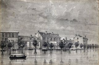
Sauvé's Crevasse was a Mississippi River levee failure in May 1849 that resulted in flooding much of New Orleans, Louisiana.
Lakeshore/Lake Vista is a neighborhood of the city of New Orleans, Louisiana. A subdistrict of the Lakeview District Area, its boundaries as defined by the City Planning Commission are: Lake Pontchartrain to the north, Bayou St. John to the east, Allen Toussaint Boulevard to the south and Pontchartrain Boulevard and the New Basin Canal to the west. The neighborhood is composed of the Lakeshore and Lake Vista subdivisions, built on land reclaimed from Lake Pontchartrain. The Lakefront is a term sometimes used to name the larger neighborhood created by the Orleans Levee Board's land reclamation initiative in early 20th century New Orleans; it includes Lakeshore and Lake Vista, as well as Lakeshore Drive and the lakefront park system, the University of New Orleans, Lake Terrace, and Lake Oaks.

Faubourg St. John, is a neighborhood in New Orleans, Louisiana, located just north of Broad Street at the intersection of Orleans Avenue. Faubourg St. John is approximately 75 city blocks in area and has an average elevation of about one foot above sea level. It was built along what is known as the Esplanade Ridge. The Esplanade Ridge Historic District was added to the National Register of Historic Places in 1980.

The Lafitte Greenway is a trail for pedestrians and bicycles located in New Orleans, Louisiana, extending from Louis Armstrong Park to Bayou St. John and beyond. Opened in 2015, it is the latest reconfiguration of a historic transportation corridor that has been in use for over two centuries.
Norman C. Francis Parkway, formerly named Jefferson Davis Parkway or Jeff Davis Parkway, is a street in New Orleans, Louisiana, United States. It runs southwest from the head of Bayou St. John in the Mid-City neighborhood to Martin Luther King, Jr. Boulevard in the Gert Town neighborhood. Like most streets in New Orleans, the segment of the parkway to the north east of Canal Street is named "North" Norman C. Francis Parkway while the segment to the southwest is denoted as "South". The parkway is wide with a grassy median except for where it crosses over the Pontchartrain Expressway.
CSS Carondelet was a sidewheel steamer that served in the Confederate States Navy during the American Civil War. Construction for the vessel started in 1861, and she was launched on January 25, 1862, and commissioned on March 16. Her sister ship was CSS Bienville. On April 4, Carondelet, along with CSS Oregon and CSS Pamlico, took part in a small naval action near Pass Christian against USS New London, USS John P. Jackson, and the troop transport USS Henry Lewis. Carondelet suffered damage to her wheel during the fight, and likely fired the only two shots that struck John P. Jackson. Later that month, with the Confederates abandoning New Orleans, Louisiana, Carondelet was scuttled by her crew in either Lake Pontchartrain, the Tchefuncte River, or the Bogue Falaya River.


