St. Charles Avenue

Last updated
19th century street-name tiles in sidewalk StChasTilesSidewalk.jpg
19th century street-name tiles in sidewalk

St. Charles Avenue (French : avenue Saint-Charles) is a thoroughfare in New Orleans, Louisiana, U.S. and the route of the St. Charles Streetcar Line. It is also famous for the dozens of mansions that adorn the tree-lined boulevard for much of the uptown section of the boulevard. It is named for St. Charles Borromeo, patron saint of Charles III of Spain, the monarch when France transferred the then-vast territory of Louisiana to Spain at the conclusion of the Seven Years War in 1763. [1]

Contents

The Southern live oak trees, plentiful in the historic Garden District, were planted during the early twentieth century. Similar additions were made on other major New Orleans streets, such as Carrollton Avenue, Napoleon Avenue, and part of Canal Street, becoming one of the city's most memorable features.

St. Charles Avenue is one of the chief Mardi Gras parade routes.

The street

New Orleans streetcar on St. Charles Avenue in the Garden District with Mardi Gras beads on a tree in the foreground. 20080622 St. Charles St. Trolley behind tree with Mardi Gras beads.JPG
New Orleans streetcar on St. Charles Avenue in the Garden District with Mardi Gras beads on a tree in the foreground.
A view of St. Charles in the downtown New Orleans Central Business District StChasUpWhitneyFromPlaceStChas2ndFloorOct07.jpg
A view of St. Charles in the downtown New Orleans Central Business District

The "downriver" end meets Canal Street. On the other side of Canal Street in the French Quarter, the corresponding street is Royal Street. From Canal Street, St. Charles runs up through the New Orleans Central Business District, then the length of Uptown New Orleans, reflecting the crescent curve of the Mississippi River but at a distance inland. It continues to the Carrollton neighborhood, ending one block past Carrollton Avenue where it intersects with Leake Street/River Road at the foot of the Mississippi River levee.

From Canal Street to Lee Circle, St. Charles Avenue is properly called St. Charles Street and is one way in the upriver direction with two lanes of traffic, with the streetcar track sharing right-of-way with one lane of motor vehicle traffic. From Lee Circle to Louisiana Avenue it has two lanes of traffic in each direction with two streetcar rail lines on the grassy tree-lined median ("neutral ground" in local parlance). From Louisiana Avenue to Carrollton Avenue it has one lane of traffic in each direction plus the streetcar neutral ground. The streetcar line turns inland at Carrollton Avenue to follow the thoroughfare, while the final stretch continues the final short block to River Road.

Major intersections, from east to west, include: Canal Street, Poydras Street, Lee Circle/Howard Avenue, Martin Luther King Jr. Boulevard/Melpomene Avenue, Jackson Avenue, Washington Avenue, Louisiana Avenue, Napoleon Avenue, Jefferson Avenue, Nashville Avenue, Broadway Street, Carrollton Avenue, and Leake Avenue.

History

For the first half of the 19th century, the portion of St. Charles above Lee Circle (then "Tivoli Circle") was known as Nyades Street. The lower portion was and is an important corridor in the Central Business District. Historically-significant buildings include Gallier Hall, which was City Hall until the 1950s.

The street was laid out atop a slight rise, the remains of an old natural levee, in connection with the construction of the New Orleans and Carrollton Railroad, which became the St. Charles Streetcar Line. The long traffic avenue originally used for horse-drawn buggies and wagons, with public rail transit running down the center, helped fuel the development of Uptown in the 19th century.

In 1889, writer Martha R. Field observed that "St. Charles Avenue is seven miles long, and is paved with asphalt its entire length" and was lined "with beautiful homes." [2]

St. Charles Avenue was the favored site for construction of mansions by the wealthy from the mid 19th century through the early years of the 20th century. A number of the old mansions were torn down in the mid- and late 20th century, until the area was declared an historic district. Many of the surviving ones have been divided into condominiums or rental apartments; others have been utilized as businesses, small hotels, and a library, while some remain individually-owned residences.

In early 1999, an effort by the New Orleans Police Department was made to clean up the Avenue and the blocks north, which were beginning to show signs of seediness. The illegal drug industry was pushed back into Central City.

During the 2005 flooding of the majority of New Orleans due to levee failures caused by Hurricane Katrina, St. Charles Avenue and the portion of Uptown closer to the Mississippi River escaped significant flooding.

Prominent buildings

The Benjamin Mansion on St. Charles Avenue - Built in 1907 EVBenjaminmansion.png
The Benjamin Mansion on St. Charles Avenue - Built in 1907

Notable buildings along St. Charles Avenue include several hotels, perhaps the most famous still in business being the Pontchartrain Hotel, in business since 1927. The Columns Hotel is a small hotel in a 19th-century mansion; part of the film Pretty Baby was made here.

The St. Charles Hotel, near Canal Street, was one of the city's two most well-known hotels through most of the 19th and early 20th centuries; it was torn down in the 1970s. (The other was the St. Louis Hotel in the French Quarter, which was replaced in the 20th century by the Royal Orleans.) The former Bienville Hotel on Lee Circle is now an apartment building.

The headquarters of the United Fruit Company was on St. Charles Avenue in the Central Business District.

The former mansion of silent-film star Marguerite Clark is now the Milton Latter Memorial branch of the New Orleans Public Library.

The facades of both Tulane University and Loyola University New Orleans are located on St. Charles Avenue, opposite Audubon Park.

See also

Related Research Articles

<span class="mw-page-title-main">New Orleans Regional Transit Authority</span> Public transit operator in New Orleans, Louisiana

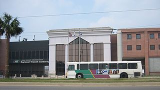
The New Orleans Regional Transit Authority is a public transportation agency based in New Orleans. The agency was established by the Louisiana State Legislature in 1979, and has operated bus and historic streetcar service throughout the city since 1983. With an annual ridership of over 18.6 million riders, the Regional Transit Authority is the largest public transit agency in the state of Louisiana.

<span class="mw-page-title-main">Streetcars in New Orleans</span>

Streetcars in New Orleans have been an integral part of the city's public transportation network since the first half of the 19th century. The longest of New Orleans' streetcar lines, the St. Charles Avenue line, is the oldest continuously operating street railway system in the world. Today, the streetcars are operated by the New Orleans Regional Transit Authority (RTA).

<span class="mw-page-title-main">Carrollton, New Orleans</span> United States historic place

Carrollton is a historic neighborhood of Uptown New Orleans, Louisiana, USA, which includes the Carrollton Historic District, recognized by the Historic District Landmark Commission. It is the part of Uptown New Orleans farthest upriver while still being easily accessible to the French Quarter. It was historically a separate town, laid out in 1833 and incorporated on March 10, 1845. Carrollton was annexed by New Orleans in 1874, but it has long retained some elements of distinct identity.

<span class="mw-page-title-main">Canal Street, New Orleans</span> Street in New Orleans, Louisiana

Canal Street is a major thoroughfare in the city of New Orleans. Forming the upriver boundary of the city's oldest neighborhood, the French Quarter or Vieux Carré, it served historically as the dividing line between the colonial-era (18th-century) city and the newer American Sector, today's Central Business District.

<span class="mw-page-title-main">Interstate 610 (Louisiana)</span> Highway in Louisiana

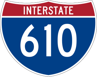
Interstate 610 (I-610) is a 4.92-mile-long (7.92 km) auxiliary route of I-10 that lies almost entirely within the city limits of New Orleans, Louisiana, bypassing its Central Business District.

<span class="mw-page-title-main">Industrial Canal</span>

The Industrial Canal is a 5.5 mile (9 km) waterway in New Orleans, Louisiana, United States. The waterway's proper name, as used by the U.S. Army Corps of Engineers and on NOAA nautical charts, is Inner Harbor Navigation Canal (IHNC). The more common "Industrial Canal" name is used locally, both by commercial mariners and by landside residents.

<span class="mw-page-title-main">17th Street Canal</span> Canal in Louisiana, United States of America

The 17th Street Canal is the largest and most important drainage canal in the city of New Orleans. Operating with Pump Station 6, it moves water into Lake Pontchartrain. The canal, along with the Orleans Canal and the London Avenue Canal, form the New Orleans Outfall Canals. The 17th Street Canal forms a significant portion of the boundary between the city of New Orleans and Metairie, Louisiana. The canal has also been known as the Metairie Outlet Canal and the Upperline Canal.

<span class="mw-page-title-main">St. Charles Streetcar Line</span> Streetcar line in New Orleans, Louisiana

The St. Charles Streetcar line is a historic streetcar line in New Orleans, Louisiana. It is the oldest continuously operating streetcar line in the world, as it has been in operation since 1835. It is operated by the New Orleans Regional Transit Authority (RTA). Officially the St. Charles Streetcar line is internally designated as Route 12, and it runs along its namesake street, St. Charles Avenue. It is the busiest route in the RTA system as it is heavily used by local commuters and tourists. On most RTA maps and publications, it is denoted in green, which is also the color of the streetcars on this line.

<span class="mw-page-title-main">Uptown New Orleans</span> United States historic place

Uptown is a section of New Orleans, Louisiana, United States, on the east bank of the Mississippi River, encompassing a number of neighborhoods between the French Quarter and the Jefferson Parish line. It remains an area of mixed residential and small commercial properties, with a wealth of 19th-century architecture. It includes part or all of Uptown New Orleans Historic District, which is listed on the National Register of Historic Places.

<span class="mw-page-title-main">Central City, New Orleans</span> New Orleans Neighborhood in Louisiana, United States

Central City is a neighborhood of the city of New Orleans. It is located at the lower end of Uptown, just above the New Orleans Central Business District, on the "lakeside" of St. Charles Avenue. A subdistrict of the Central City/Garden District Area, its boundaries as defined by the City Planning Commission are: MLK Boulevard, South Claiborne Avenue and the Pontchartrain Expressway to the north, Magazine, Thalia, Prytania and Felicity Streets and St. Charles Avenue to the south and Toledano Street, Louisiana Avenue and Washington Avenue to the west. This old predominantly African-American neighborhood has been important in the city's brass band and Mardi Gras Indian traditions.

<span class="mw-page-title-main">16th Ward of New Orleans</span>

The 16th Ward or Sixteenth Ward is a division of the city of New Orleans, Louisiana, one of the 17 Wards of New Orleans. It is an Uptown ward, along with the adjacent 17th Ward, formerly part of the city of Carrollton, Louisiana which was annexed by New Orleans in the 1870s.

<span class="mw-page-title-main">Bayou St. John</span> River in Louisiana, United States

Bayou St. John is a bayou within the city of New Orleans, Louisiana.

<span class="mw-page-title-main">U.S. Route 90 Business (New Orleans, Louisiana)</span> Highway in New Orleans, Louisiana

U.S. Highway 90 Business is a business route of U.S. Highway 90 located in and near New Orleans, Louisiana. It runs 14.25 miles (22.93 km) in a general east–west direction from US 90 in Avondale to a junction with Interstate 10 (I-10) and US 90 in the New Orleans Central Business District.

<span class="mw-page-title-main">Sauvé's Crevasse</span>

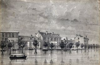
Sauvé's Crevasse was a Mississippi River levee failure in May 1849 that resulted in flooding much of New Orleans, Louisiana.

<span class="mw-page-title-main">U.S. Route 90 in Louisiana</span> Highway in Louisiana

U.S. Highway 90 (US 90), one of the major east–west U.S. Highways in the Southern United States, runs through southern Louisiana for 297.6 miles (478.9 km), serving Lake Charles, Lafayette, New Iberia, Morgan City, and New Orleans. Much of it west of Lafayette and east of New Orleans has been supplanted by Interstate 10 (I-10) for all but local traffic, but the section between Lafayette and New Orleans runs a good deal south of I-10.

<span class="mw-page-title-main">Carrollton Avenue</span>

Carrollton Avenue is a major thoroughfare stretching 3.9 miles (6.3 km) across the Uptown/Carrollton and Mid-City districts of New Orleans. South Carrollton Avenue runs from St. Charles Avenue in the Riverbend in a northeast lake-bound direction through Carrollton and into Mid-City. After crossing Canal Street it continues as North Carrollton Avenue until intersecting with Esplanade Avenue and Wisner Boulevard at the entrance to City Park.

<span class="mw-page-title-main">Esplanade Avenue, New Orleans</span> Historic Street in New Orleans

Esplanade Avenue is a historic street in New Orleans, Louisiana. It runs northwest from the Mississippi River to Beauregard Circle at the entrance to City Park.

<span class="mw-page-title-main">Canal Streetcar Line</span> Historic streetcar line in New Orleans, Louisiana

The Canal Streetcar line is a historic streetcar line in New Orleans, Louisiana. It is operated by the New Orleans Regional Transit Authority (RTA). It originally operated from 1861 to 1964. It was redesigned and rebuilt between 2000 and 2004, and operation was reinstated in 2004 after a 40-year hiatus. Primarily running along its namesake street, Canal Street, it consists of two branches named for their outer terminals, totaling about 5+12 miles (8.9 km) in length: "Canal – Cemeteries" and "Canal – City Park / Museum". Each branch is denoted with the red and light green colors respectively on most RTA publications.

<span class="mw-page-title-main">Louisiana Highway 613</span>

Louisiana Highway 613 was a collection of four state-maintained streets in Metairie and New Orleans established with the 1955 Louisiana Highway renumbering. All four routes have since been deleted from the state highway system.

References

  1. Melinda Morris, "St. Charles Avenue: Vintage Photos from the Times-Picayune Archives," nola.com, 23 August 2017 .
  2. "title". catharinecole.startlogic.com. Archived from the original on 2010-09-14.

Further reading

Coordinates: 29°55′45″N90°06′03″W / 29.9291°N 90.1007°W / 29.9291; -90.1007