Related Research Articles
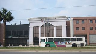
The New Orleans Regional Transit Authority is a public transportation agency based in New Orleans. The agency was established by the Louisiana State Legislature in 1979, and has operated bus and historic streetcar service throughout the city since 1983. With an annual ridership of over 18.6 million riders, the Regional Transit Authority is the largest public transit agency in the state of Louisiana.

Streetcars in New Orleans have been an integral part of the city's public transportation network since the first half of the 19th century. The longest of New Orleans' streetcar lines, the St. Charles Avenue line, is the oldest continuously operating street railway system in the world. Today, the streetcars are operated by the New Orleans Regional Transit Authority (RTA).

The Faubourg Marigny is a neighborhood of the city of New Orleans, Louisiana, United States.

Bywater is a neighborhood of the city of New Orleans. A subdistrict of the Bywater District Area, its boundaries as defined by the City Planning Commission are: Florida Avenue to the north, the Industrial Canal to the east, the Mississippi River to the south, and the railroad tracks along Homer Plessy Way to the west. Bywater is part of the Ninth Ward of New Orleans; but it is located along the natural levee of the Mississippi River, sparing the area from significant flooding. It includes part or all of Bywater Historic District, which is listed on the National Register of Historic Places.
The Pontchartrain Expressway is a parallel six-lane section of Interstate 10 (I-10) and U.S. Route 90 Business in New Orleans, Louisiana, USA, with a brief stand-alone section in between junctions with these highways. The designation begins on I-10 near the Orleans–Jefferson parish line at the I-610 Split. The expressway follows I-10 into the Central Business District (CBD) of New Orleans and then follows US 90 Bus. to the Crescent City Connection. The expressway takes its name from Pontchartrain Boulevard, which the expressway replaced in some areas. The Pontchartrain name is derived from Lake Pontchartrain, which New Orleans' northern border traverses.

Uptown is a section of New Orleans, Louisiana, United States, on the east bank of the Mississippi River, encompassing a number of neighborhoods between the French Quarter and the Jefferson Parish line. It remains an area of mixed residential and small commercial properties, with a wealth of 19th-century architecture. It includes part or all of Uptown New Orleans Historic District, which is listed on the National Register of Historic Places.

Central City is a neighborhood of the city of New Orleans. It is located at the lower end of Uptown, just above the New Orleans Central Business District, on the "lakeside" of St. Charles Avenue. A subdistrict of the Central City/Garden District Area, its boundaries as defined by the City Planning Commission are: MLK Boulevard, South Claiborne Avenue and the Pontchartrain Expressway to the north, Magazine, Thalia, Prytania and Felicity Streets and St. Charles Avenue to the south and Toledano Street, Louisiana Avenue and Washington Avenue to the west. This old predominantly African-American neighborhood has been important in the city's brass band and Mardi Gras Indian traditions.

Elysian Fields Avenue is a broad, straight avenue in New Orleans named after the Avenue des Champs-Élysées in Paris. It courses south to north from the Lower Mississippi River to Lake Pontchartrain, a distance of approximately 5 miles (8.0 km). The avenue intersects with Interstate 610, Interstate 10, and U.S. Highway 90, Gentilly Boulevard passing by Brother Martin High School. The part between North Claiborne Avenue and Gentilly Boulevard is Louisiana Highway 3021 ; the piece from N. Claiborne Avenue south to St. Claude Avenue carries Louisiana Highway 46.
U.S. Highway 90 Business is a business route of U.S. Highway 90 located in and near New Orleans, Louisiana. It runs 14.25 miles (22.93 km) in a general east–west direction from US 90 in Avondale to a junction with Interstate 10 (I-10) and US 90 in the New Orleans Central Business District.

U.S. Highway 90 (US 90), one of the major east–west U.S. Highways in the Southern United States, runs through southern Louisiana for 297.6 miles (478.9 km), serving Lake Charles, Lafayette, New Iberia, Morgan City, and New Orleans. Much of it west of Lafayette and east of New Orleans has been supplanted by Interstate 10 (I-10) for all but local traffic, but the section between Lafayette and New Orleans runs a good deal south of I-10.
Royal Street is a street in the French Quarter of New Orleans, Louisiana, U.S. It is one of the original streets of the city, dating from the early 18th century, and is known today for its antique shops, art galleries, and hotels.

The Earhart Expressway, named for former New Orleans Commissioner of Public Utilities, Fred A. Earhart, is a state highway located in both Jefferson Parish and Orleans Parish, Louisiana. It is also designated as Louisiana Highway 3139, spanning a total of 5.2 miles (8.4 km). Although it is an odd-numbered highway and is bannered north/south, it travels in a more east-to-west direction.

Decatur Street is a street in the French Quarter neighborhood of New Orleans, Louisiana, USA that runs parallel to the Mississippi River. Decatur was formerly known as "Levee Street" or Rue de la Levée, as it was originally the location of the levee. In 1870, when the river had altered its course, it was renamed "Decatur Street" in honor of the naval hero Stephen Decatur Jr.

Carrollton Avenue is a major thoroughfare stretching 3.9 miles (6.3 km) across the Uptown/Carrollton and Mid-City districts of New Orleans. South Carrollton Avenue runs from St. Charles Avenue in the Riverbend in a northeast lake-bound direction through Carrollton and into Mid-City. After crossing Canal Street it continues as North Carrollton Avenue until intersecting with Esplanade Avenue and Wisner Boulevard at the entrance to City Park.

Gert Town is a neighborhood in the city of New Orleans, Louisiana. It is the home to Xavier University of Louisiana and is a part of the Mid-City District. Gert Town played a major role in the industrial development of the New Orleans region. The Blue Plate Mayonnaise Factory, Coca-Cola Bottling Plant, Sealtest Dairy, and Thompson-Hayward Chemical Company were all fundamental manufacturing bases of the working-class neighborhood. Gert Town was also well known for being a center of development for jazz and other music genres. Musicians such as Buddy Bolden, John Robichaux, Merry Clayton, Bunk Johnson and Allen Toussaint all came from the neighborhood and helped shape the musical influence of New Orleans.

Claiborne Avenue is a major thoroughfare in New Orleans, Louisiana. It runs the length of the city, about 9.5 miles (15.3 km), beginning at the Jefferson Parish line and ending at the St. Bernard Parish line; the street continues under different names in both directions. It is called South Claiborne Avenue upriver from Canal Street and North Claiborne Avenue from Canal to St. Bernard Parish.

Frenchmen Street is in the 7th Ward of New Orleans, Louisiana. It is best known for the three-block section in the Faubourg Marigny neighborhood which is home to some of the city's popular live-music venues including Cafe Negril, Favela Chic, Vaso, Apple Barrel, Blue Nile, Snug Harbor, the Spotted Cat, and the Maison in addition to restaurants, bars, a record store, a book shop, and other local businesses such as the R&B Bed and Breakfast, in front of Washington Park.
Louisiana Highway 3046 is a state highway in Louisiana that serves Jefferson Parish. It spans 1.0 mile (1.6 km) in a south to north direction. It is known locally as Causeway Boulevard.
The Seventh Ward is a neighborhood of the city of New Orleans. A sub-district of the Mid-City District Area, its boundaries as defined by the New Orleans City Planning Commission are: A.P. Tureaud Avenue, Agriculture, Allen, Industry, St. Anthony, Duels, Frenchmen and Hope Streets to the north, Elysian Fields Avenue to the east, St. Claude and St. Bernard Avenues, North Rampart Street and Esplanade Avenue to the south, and North Broad Street to the west.
Norman C. Francis Parkway, formerly named Jefferson Davis Parkway or Jeff Davis Parkway, is a street in New Orleans, Louisiana, United States. It runs southwest from the head of Bayou St. John in the Mid-City neighborhood to Martin Luther King, Jr. Boulevard in the Gert Town neighborhood. Like most streets in New Orleans, the segment of the parkway to the north east of Canal Street is named "North" Norman C. Francis Parkway while the segment to the southwest is denoted as "South". The parkway is wide with a grassy median except for where it crosses over the Pontchartrain Expressway.
References
- John Churchill Chase (1st Edition was published in 1949.) (1997). Frenchmen, Desire, Good Children and Other Streets of New Orleans, 3rd Edition. Touchstone. ISBN 0-684-84570-9
- Elaine Lacoste (1997). Street Names & Picayune Histories of New Orleans. Ho'olauna Hawaii, Ltd. ISBN 0-9656409-0-6