Related Research Articles

The French Quarter, also known as the Vieux Carré, is the oldest neighborhood in the city of New Orleans. After New Orleans was founded in 1718 by Jean-Baptiste Le Moyne de Bienville, the city developed around the Vieux Carré, a central square. The district is more commonly called the French Quarter today, or simply "The Quarter," related to changes in the city with American immigration after the 1803 Louisiana Purchase. Most of the extant historic buildings were constructed either in the late 18th century, during the city's period of Spanish rule, or were built during the first half of the 19th century, after U.S. annexation and statehood.

Streetcars in New Orleans have been an integral part of the city's public transportation network since the first half of the 19th century. The longest of New Orleans' streetcar lines, the St. Charles Avenue line, is the oldest continuously operating street railway system in the world. Today, the streetcars are operated by the New Orleans Regional Transit Authority (RTA).

Carrollton is a historic neighborhood of Uptown New Orleans, Louisiana, USA, which includes the Carrollton Historic District, recognized by the Historic District Landmark Commission. It is the part of Uptown New Orleans farthest upriver while still being easily accessible to the French Quarter. It was historically a separate town, laid out in 1833 and incorporated on March 10, 1845. Carrollton was annexed by New Orleans in 1874, but it has long retained some elements of distinct identity.

The Central Business District (CBD) is a neighborhood of the city of New Orleans, Louisiana, United States.

The Garden District is a neighborhood of the city of New Orleans, Louisiana, United States. A subdistrict of the Central City/Garden District Area, its boundaries as defined by the New Orleans City Planning Commission are: St. Charles Avenue to the north, 1st Street to the east, Magazine Street to the south, and Toledano Street to the west. The National Historic Landmark district extends a little farther.

Bywater is a neighborhood of the city of New Orleans. A subdistrict of the Bywater District Area, its boundaries as defined by the City Planning Commission are: Florida Avenue to the north, the Industrial Canal to the east, the Mississippi River to the south, and the railroad tracks along Homer Plessy Way to the west. Bywater is part of the Ninth Ward of New Orleans; but it is located along the natural levee of the Mississippi River, sparing the area from significant flooding. It includes part or all of Bywater Historic District, which is listed on the National Register of Historic Places.
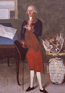
Francisco Luis Héctor de Carondelet y Bosoist, 5th Baron of Carondelet, was a Spanish administrator of partial Burgundian descent in the employ of the Spanish Empire. He was a Knight of Malta.

In New Orleans, Louisiana, United States, downtown has historically referred to neighborhoods along the Mississippi River, downriver from Canal Street – including the French Quarter, Tremé, Faubourg Marigny, Bywater, the 9th Ward, and other neighborhoods. Contrary to the common usage of the term downtown in other cities, this historic application of the term excluded the New Orleans Central Business District. The term continues to be employed as it has been historically, although many younger people and migrants from other parts of the country will use "downtown" as it is used elsewhere; that is, to mean the Central Business District/Warehouse District area.

Basin Street or Rue Bassin in French, is a street in New Orleans, Louisiana. It parallels Rampart Street one block lakeside, or inland, from the boundary of the French Quarter, running from Canal Street down 5 blocks past Saint Louis Cemetery. It currently then turns lakewards, flowing into Orleans Avenue.

The St. Charles Streetcar line is a historic streetcar line in New Orleans, Louisiana. It is the oldest continuously operating streetcar line in the world, as it has been in operation since 1835. It is operated by the New Orleans Regional Transit Authority (RTA). Officially the St. Charles Streetcar line is internally designated as Route 12, and it runs along its namesake street, St. Charles Avenue. It is the busiest route in the RTA system as it is heavily used by local commuters and tourists. On most RTA maps and publications, it is denoted in green, which is also the color of the streetcars on this line.

The Carondelet Canal, also known as the Old Basin Canal, was a canal in New Orleans, Louisiana, U.S.A., operating from 1794 into the 1920s – nearly 135 years.

Broadmoor is a neighborhood of the city of New Orleans. A subdistrict of the Uptown/Carrollton Area, its boundaries as defined by the New Orleans City Planning Commission are: Eve Street to the north, Washington Avenue and Toledano Street to the east, South Claiborne Avenue to the south, and Jefferson Avenue, South Rocheblave Street, Nashville Avenue, and Octavia Street to the west. It includes the Broadmoor Historic District which was listed on the National Register of Historic Places in 2003 and increased in its boundaries in 2007.

Uptown is a section of New Orleans, Louisiana, United States, on the east bank of the Mississippi River, encompassing a number of neighborhoods between the French Quarter and the Jefferson Parish line. It remains an area of mixed residential and small commercial properties, with a wealth of 19th-century architecture. It includes part or all of Uptown New Orleans Historic District, which is listed on the National Register of Historic Places.

The New Basin Canal, also known as the New Canal and the New Orleans Canal, is a shipping canal in New Orleans, Louisiana, operating from 1830s into the 1940s.

Rampart Street is a historic avenue located in New Orleans, Louisiana.
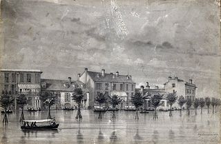
Sauvé's Crevasse was a Mississippi River levee failure in May 1849 that resulted in flooding much of New Orleans, Louisiana.

St. Charles Avenue is a thoroughfare in New Orleans, Louisiana, U.S. and the home of the St. Charles Streetcar Line. It is also famous for the dozens of mansions that adorn the tree-lined boulevard for much of the uptown section of the boulevard.

The Hennen Building, also known as the Canal-Commercial Building,Maritime Building, and briefly the Latter & Blum Building, is an 11-story, 158 feet (48 m)-tall skyscraper in New Orleans, Louisiana USA. A Registered Historic Place, the building is located at 800 Common Street at the uptown lake corner with Carondelet Street, in the New Orleans Central Business District. The building is New Orleans' first and oldest skyscraper, holding the title of the city's tallest building from 1895-1904.

Congregation Beth Israel is a Modern Orthodox synagogue located in Louisiana. Founded in 1903 or 1904, though tracing its roots back to 1857, it is the oldest Orthodox congregation in the New Orleans region. Originally located on Carondelet Street in New Orleans' Central City, it constructed and moved to a building at 7000 Canal Boulevard in Lakeview, New Orleans, in 1971.
Norman C. Francis Parkway, formerly named Jefferson Davis Parkway or Jeff Davis Parkway, is a street in New Orleans, Louisiana, United States. It runs southwest from the head of Bayou St. John in the Mid-City neighborhood to Martin Luther King, Jr. Boulevard in the Gert Town neighborhood. Like most streets in New Orleans, the segment of the parkway to the north east of Canal Street is named "North" Norman C. Francis Parkway while the segment to the southwest is denoted as "South". The parkway is wide with a grassy median except for where it crosses over the Pontchartrain Expressway.
References
- ↑ Zacharie, James S. (1885). New Orleans guide: with descriptions of the routes to New Orleans, sights of the city arranged alphabetically ... also, outlines of the history of Louisiana. New Orleans: The New Orleans News Company. p. 60. OCLC 7706464.
- ↑ Lachoff, Irwin; Kahn, Catherine C. (2005). The Jewish Community of New Orleans. Charleston, SC: Arcadia Publishing. pp. 8+. ISBN 978-0-7385-1835-0.
- ↑ Bruno, R. Stephanie (February 25, 2011). "Three's Company on House-Proud Carondelet Street". Times-Picayune . New Orleans. Retrieved October 13, 2011.
| Wikimedia Commons has media related to Carondelet Street, New Orleans . |
| | This Louisiana road or road transport-related article is a stub. You can help Wikipedia by expanding it. |