Related Research Articles

Tremé is a neighborhood in New Orleans, Louisiana. "Tremé" is often rendered as Treme, and the neighborhood is sometimes called by its more formal French name, Faubourg Tremé; it is listed in the New Orleans City Planning Districts as Tremé / Lafitte, from when including the Lafitte Projects.

Metairie Cemetery is a cemetery in southeastern Louisiana. The name has caused some people to mistakenly presume that the cemetery is located in Metairie, Louisiana, but it is located within the New Orleans city limits, on Metairie Road.

Basin Street or Rue Bassin in French, is a street in New Orleans, Louisiana. It parallels Rampart Street one block lakeside, or inland, from the boundary of the French Quarter, running from Canal Street down 5 blocks past Saint Louis Cemetery. It currently then turns lakewards, flowing into Orleans Avenue.

Uptown is a section of New Orleans, Louisiana, United States, on the east bank of the Mississippi River, encompassing a number of neighborhoods between the French Quarter and the Jefferson Parish line. It remains an area of mixed residential and small commercial properties, with a wealth of 19th-century architecture. It includes part or all of Uptown New Orleans Historic District, which is listed on the National Register of Historic Places.
The 3rd Ward or Third Ward is one of the 17 Wards of New Orleans, a division of the city of New Orleans, Louisiana.
The 10th Ward is a division of the city of New Orleans, Louisiana. The 10th Ward is one of the 17 wards of New Orleans. The ward is one of the city's Uptown wards, formerly the old Faubourg Lafayette annexed by New Orleans in the 1850s.

Mid-City is a neighborhood of the city of New Orleans. A sub-district of the Mid-City District Area, its boundaries as defined by the New Orleans City Planning Commission are: City Park Avenue, Toulouse Street, North Carrollton, Orleans Avenue, Bayou St. John and St. Louis Street to the north, North Broad Street to the east, and the Pontchartrain Expressway to the west. It is a historic district on the National Register of Historic Places. In common usage, a somewhat larger area surrounding these borders is often also referred to as part of Mid-City.

Gert Town is a neighborhood in the city of New Orleans, Louisiana. It is the home to Xavier University of Louisiana and is a part of the Mid-City District. Gert Town played a major role in the industrial development of the New Orleans region. The Blue Plate Mayonnaise Factory, Coca-Cola Bottling Plant, Sealtest Dairy, and Thompson-Hayward Chemical Company were all fundamental manufacturing bases of the working-class neighborhood. Gert Town was also well known for being a center of development for jazz and other music genres. Musicians such as Buddy Bolden, John Robichaux, Merry Clayton, Bunk Johnson and Allen Toussaint all came from the neighborhood and helped shape the musical influence of New Orleans.

The Robert E. Lee Monument, formerly in New Orleans, Louisiana, is a historic statue dedicated to Confederate General Robert E. Lee by noted American sculptor Alexander Doyle. It was removed (intact) by official order and moved to an unknown location on May 19, 2017. Any future display is uncertain. The monument was listed on the National Register of Historic Places in 1991. It was included by New Orleans magazine in June 2011 as one of the city's "11 important statues".
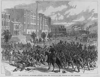
The Battle of Liberty Place, or Battle of Canal Street, was an attempted insurrection and coup d'etat by the Crescent City White League against the Reconstruction Era Louisiana Republican state government on September 14, 1874, in New Orleans, which was the capital of Louisiana at the time. Five thousand members of the White League, a paramilitary terrorist organization made up largely of Confederate veterans, fought against the outnumbered New Orleans Metropolitan Police and state militia. The insurgents held the statehouse, armory, and downtown for three days, retreating before arrival of Federal troops that restored the elected government. No insurgents were charged in the action. This was the last major event of violence stemming from the disputed 1872 gubernatorial election, after which Democrat John McEnery and Republican William Pitt Kellogg both claimed victory.

Lee Circle is a central traffic circle in New Orleans, Louisiana, which featured a monument to Confederate General Robert E. Lee between 1884 and 2017. The monument was a bronze statue by Alexander Doyle, a prominent American sculptor known for statues of Civil War figures. Lee Circle is located at the intersection of St. Charles and Howard Avenues. Prior to the erection of the monument, the location was known as Tivoli Circle or Place du Tivoli. Tivoli Circle was an important, central point in the city, as it linked upriver areas with downriver areas. It was a common local meeting point and the site remains a popular place to gather for Mardi Gras parades.

The General Beauregard Equestrian Statue, honoring P. G. T. Beauregard, was located in New Orleans, Louisiana, United States. The statue, by Alexander Doyle, one of the premier American sculptors, was officially unveiled in 1915.
The neighborhood of Faubourg Lafayette is a division in the city of New Orleans, Louisiana. It is also known as the 10th Ward of New Orleans, and it is one of the city's 17 wards. Faubourg Lafayette was founded with small settlements around steamboat landings in New Orleans. John Poultney acquired the property from Madame Rousseau on May 2, 1818. This was a plantation measuring about ten acres, near the Mississippi River waterfront. The property was bounded by the lower line of the property that was owned by Jacques François Enoul de Livaudais. This property ran through the squares between Soraparu and First streets at Tchoupitoulas Street. St. Andrew Street is the street that bounds the property below.
Athletic Park was a sports stadium in New Orleans, Louisiana which opened in 1901. Some sources say the ballpark was located on the south side of Tulane Avenue between South Carrollton Avenue and South Pierce Street. The Sanborn map from 1908 shows the actual boundaries as Tulane Avenue, Scott Street, the proposed Gravier Street extension, and then railroad tracks and the canal ; and the proposed Pierce Street extension. Carrolton Avenue was a block west of Pierce.

The Jefferson Davis Monument, also known as the Jefferson Davis Memorial, was an outdoor sculpture and memorial to Jefferson Davis, installed at Jeff Davis Parkway and Canal Street in New Orleans, Louisiana, United States from 1911 to 2017.
Since the 1960s, many municipalities in the United States have removed monuments and memorials on public property dedicated to the Confederate States of America, and some, such as Silent Sam in North Carolina, have been torn down by protestors. The momentum to remove Confederate memorials increased dramatically following high-profile incidents including the Charleston church shooting (2015), the Unite the Right rally (2017), and the murder of George Floyd (2020). The removals have been driven by historical analysis that the monuments express and re-enforce white supremacy; memorialize an unrecognized, treasonous government, the Confederacy, whose founding principle was the perpetuation and expansion of slavery; and that the presence of these Confederate memorials over a hundred years after the defeat of the Confederacy continues to disenfranchise and alienate African Americans.
References
- ↑ Hemard, Ned (2017). "New Orleans Nostalgia: Evolution of the Parkway" (PDF).
- ↑ Kailas, M. (2017). "New Orleans Neighborhood Series: Tulane/Gravier".
- ↑ Asher, Sally (2014). Hope & New Orleans: A History of Crescent City Street Names. History Press Library Editions.
- ↑ "See all 4 Confederate monument removals in New Orleans in photos and video". nola.com.
- ↑ "City Council renames Jeff Davis Parkway for Norman Francis; other street, park names could follow".
- ↑ "Rename Jeff Davis Parkway for Dr. Norman Francis, New Orleans mayors say in powerful editorial". The Advocate.
| | This Louisiana road or road transport-related article is a stub. You can help Wikipedia by expanding it. |