
Tremé is a neighborhood in New Orleans, Louisiana. "Tremé" is often rendered as Treme, and the neighborhood is sometimes called by its more formal French name, Faubourg Tremé; it is listed in the New Orleans City Planning Districts as Tremé / Lafitte, from when including the Lafitte Projects.

A rail trail is the conversion of a disused railway track into a multi-use path, typically for walking, cycling and sometimes horse riding and snowmobiling. The characteristics of abandoned railways—flat, long, frequently running through historical areas—are appealing for various developments. The term sometimes also covers trails running alongside working railways; these are called "rails with trails". Some shared trails are segregated, with the segregation achieved with or without separation. Many rail trails are long-distance trails.
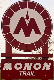
The Monon Trail is a rail trail located entirely within the state of Indiana. The Monon Railroad was a popular railroad line connecting the cities of Chicago and Indianapolis, with stops at major settlements along its route. After the decline of railroad travel and the sale of the company in 1987, the portion of the line between Indianapolis and Delphi, Indiana, was abandoned.

The Bloomingdale Trail is a 2.7-mile (4.3 km) elevated rail trail running east–west on the northwest side of Chicago. It is the longest greenway project of a former rail line in the United States, and the second longest in the world, after the Promenade plantee rail trail in Paris. In 2015, the City of Chicago converted the former Bloomingdale Line into an elevated greenway, which forms the backbone of the linear park and trail network called The 606. The Bloomingdale Trail elevated park touches the neighborhoods of Logan Square, Humboldt Park, and West Town.

The Carondelet Canal, also known as the Old Basin Canal, was a canal in New Orleans, Louisiana, U.S.A., operating from 1794 into the 1920s – nearly 135 years.
The Orleans Canal is a drainage canal in New Orleans, Louisiana. The canal, along with the 17th Street Canal and the London Avenue Canal, form the New Orleans Outfall Canals. The current version of the canal is about 2 km long, running along the up-river side of City Park, through the Lakeview and Lakeshore neighborhood, and into Lake Pontchartrain. It is part of the system used to pump rain water out of the streets of the city into the Lake. The Canal has also been known as the Orleans Avenue Canal, the Orleans Outfall Canal, the Orleans Tail Race, and early on, the Girod Canal.

A greenway is usually a shared-use path along a strip of undeveloped land, in an urban or rural area, set aside for recreational use or environmental protection. Greenways are frequently created out of disused railways, canal towpaths, utility or similar rights of way, or derelict industrial land. Greenways also can also be linear parks, and can serve as wildlife corridors. The path's surface may be paved and often serves multiple users: walkers, runners, bicyclists, skaters and hikers. A characteristic of greenways, as defined by the European Greenways Association, is "ease of passage": that is that they have "either low or zero gradient", so that they can be used by all "types of users, including mobility impaired people".

Navarre is a neighborhood of the city of New Orleans. A subdistrict of the Lakeview District Area, its boundaries as defined by the City Planning Commission are: I-610, Canal Boulevard and Florida Boulevard to the north, Orleans Avenue to the east, City Park Avenue to the south and the Pontchartrain Expressway and Pontchartrain Boulevard to the west.

Bayou St. John is a bayou within the city of New Orleans, Louisiana.
In 1980 the New Orleans City Planning Commission divided the city into 13 planning districts and 72 distinct neighborhoods. See Orleans Parish neighborhood map

Lakeview is a neighborhood of the city of New Orleans. A subdistrict of the Lakeview District Area, its boundaries as defined by the City Planning Commission are: Robert E. Lee Boulevard to the north, Orleans Avenue to the east, Florida Boulevard, Canal Boulevard and I-610 to the south and Pontchartrain Boulevard to the west. Lakeview is sometimes used to describe the entire area bounded by Lake Pontchartrain to the north, the Orleans Avenue Canal to the east, City Park Avenue to the south and the 17th Street Canal to the west. This larger definition includes the West End, Lakewood and Navarre neighborhoods, as well as the Lakefront neighborhoods of Lakeshore and Lake Vista.

The Genesee Valley Greenway is a rail trail in western New York's Genesee River valley.
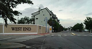
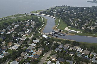
West End is a neighborhood of the city of New Orleans. A subdistrict of the Lakeview District Area, its boundaries as defined by the City Planning Commission are: Lake Pontchartrain to the north, the New Basin Canal and Pontchartrain Boulevard to the east, Veterans Boulevard to the south, and the 17th Street Canal to the west. The area was largely built on land reclaimed from Lake Pontchartrain. It is a commercial seafood and recreational boating hub for the city and has been known for its seafood restaurants. In recent years, the area has seen large condominium-complex developments built which overlook the Lake, marinas, and centrally located 30-acre (120,000 m2) West End Park.

Claiborne Avenue is a major thoroughfare in New Orleans, Louisiana. It runs the length of the city, about 9.5 miles (15.3 km), beginning at the Jefferson Parish line and ending at the St. Bernard Parish line; the street continues under different names in both directions. It is called South Claiborne Avenue upriver from Canal Street and North Claiborne Avenue from Canal to St. Bernard Parish.

The Springwater Corridor Trail is a bicycle and pedestrian rail trail in the Portland metropolitan area in Oregon, United States. It follows a former railway line from Boring through Gresham to Portland, where it ends south of the Eastbank Esplanade. Most of the corridor, about 21 miles (34 km) long, consists of paved, off-street trail, though about 1 mile (1.6 km) overlaps city streets in Portland's Sellwood neighborhood. A large segment roughly follows the course of Johnson Creek and crosses it on bridges many times. Much of the corridor was acquired by the City of Portland in 1990; remaining segments were acquired by Metro thereafter.
Lakeshore/Lake Vista is a neighborhood of the city of New Orleans, Louisiana. A subdistrict of the Lakeview District Area, its boundaries as defined by the City Planning Commission are: Lake Pontchartrain to the north, Bayou St. John to the east, Robert E. Lee Boulevard to the south and Pontchartrain Boulevard and the New Basin Canal to the west. The neighborhood is composed of the Lakeshore and Lake Vista subdivisions, built on land reclaimed from Lake Pontchartrain. The Lakefront is a term sometimes used to name the larger neighborhood created by the Orleans Levee Board's land reclamation initiative in early 20th century New Orleans; it includes Lakeshore and Lake Vista, as well as Lakeshore Drive, the lakefront park system, the University of New Orleans, Lake Terrace, and Lake Oaks.

The Palatka-Lake Butler State Trail (PLB) corridor stretches nearly 47 miles (76 km) from the vicinity of Lake Butler, Florida to Palatka, Florida. The project is located along the former Georgia Southern and Florida Railway right-of-way and the trail is being constructed on top of the existing abandoned railroad bed through Putnam, Clay, Bradford, and Union counties.
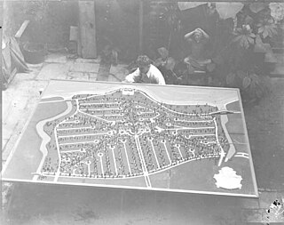
New Faubourg Lafitte is a residential development in New Orleans, Louisiana, U.S.A.. It largely occupies the area formerly filled by the since demolished Lafitte Projects public housing.

The Onondaga Creekwalk is a mostly paved, partly bricked, multi-use trail running 4.8 miles (7.7 km) in Syracuse, New York, which has so far seen more than three decades of planning, construction, and delays, starting in 1988. The trail is designed for bicyclists, skaters, and pedestrians to approximately parallel any desired portion of Onondaga Creek's run connecting Kirk Park on Syracuse's South Side, downstream through downtown at Armory Square, and then on to Onondaga Lake at the creek's ultimate mouth.
Norman C. Francis Parkway, formerly named Jefferson Davis Parkway or Jeff Davis Parkway, is a street in New Orleans, Louisiana. It runs southwest from the head of Bayou St. John in the Mid-City neighborhood to Martin Luther King, Jr. Boulevard in the Gert Town neighborhood. Like most streets in New Orleans, the segment of the parkway to the north east of Canal Street is named "North" Norman C. Francis Parkway while the segment to the southwest is denoted as "South". The parkway is wide with a grassy median except for where it crosses over the Pontchartrain Expressway.

